

Gem Pool along the trail
Mount Washington, located in White Mountain National Forest, has more claims to fame than many mountains on the east coast. For one thing, east of the Mississippi, only North Carolina and Tennessee have higher peaks than the top of Mount Washington (6,288 feet above sea level). Also, in 1934, the highest wind speed outside of a tornado or typhoon was recorded on top of the mountain. Still, the mountain isn’t difficult to access, as a road climbs to the top, the Cog Railway daily ascends the mountain during the summer, and numerous trails take hikers up the peak. We decided to try out the Ammonoosuc Ravine Trail on our trek to the top, since a couple members of my group had done it on their honeymoon, 30 years ago. It isn’t the shortest route, but it’s quite pretty. You’re following a waterfall most of the way, and once you get above the tree line, you get some awesome views of the big mountain, as well as the surrounding area. This trail takes you from the Cog Railway to Lake of the Clouds; you can then take a trail up Mount Washington itself, or you can hike over a ridge via the Appalachian Trail to see some of the other mountains in the Presidential Range. Due to snow on the trail and the 70mph winds that nearly blew us off our feet and the 80mph gusts that did blow us off our feet, we decided that the Presidential Range was a better trail to take than the one up Mount Washington!
Getting to the Ammonoosuc Ravine Trailhead
To get to the parking area for the Ammonoosuc Ravine Trail, take US 302 to the town of Bretton Woods. Actually, if you’re coming from the north, you don’t want to drive all the way to the town. Just before the town, on the north side, US 302 will cross a river (the Ammonoosuc River). Don’t cross the river (or, if you’re coming from the south, cross the river). Follow the signs for the Cog Railway down a road that crosses the railroad tracks. I believe this is called Base Station Road. Drive 5.5 miles down this road to a “Trailhead Parking” parking area on your right. A sign will mark this. As soon as you enter the parking area, you will be faced with a signboard. This is the same parking area as for the Jewel Trail, which follows a ridge and the Cog Railway to the top of Mount Washington. I’ve never done the Jewel trail, but from maps I can see that it doesn’t go to Lake of the Clouds, yet is still longer than taking the Ammonoosuc Ravine Trail to the top of the mountain. There is a $3 fee to park in this area.

A waterfall along the trail
If you don’t want to pay the fee, drive only 4.5 miles down Base Station Road, then make a right turn onto Mt. Clinton Road. Drive down this road for 1.3 miles to a small parking area on your left. You can park here for free. Walk back up the road 1.3 miles to Base Station Road, turn right, and then hike about a mile up to the Ammonoosuc Ravine Trailhead. If you take the ridge hike back across Mount Monroe and Mount Franklin (via the Appalachian Trail), you will eventually hike right back to your vehicle in this parking area. Another alternative place to park—although I’m not sure if a fee is charged here or not—is to drive another 0.2 miles up beyond the Ammonoosuc Ravine Trailhead towards Mansfield Station (the Cog Railway). Park in the dirt parking area. The Cog Railway personnel request that hikers park here instead of in the Mansfield Station parking area. You can either walk the 0.2 miles back to the Ammonoosuc Ravine Trailhead, or you can hike up beyond Mansfield Station to an alternative trail that will bring you to the Ammonoosuc Ravine Trail after a short distance. I’ll describe both the Ammonoosuc Ravine Trail and this alternative trail below.

Snowy Trail
First, let me explain that this is part one of a two-part post. (The other will be available In this post, I’ll take you up to Lake of the Clouds. In another post, I’ll take you across Mount Monroe and Mount Franklin via the Appalachian Trail and down the Edmonds Path to the parking area on Mt. Clinton Road. From here you can hike back to your vehicle if you parked along Base Station Road. Because of the wind and snow we didn’t make it to the top of Mount Washington, but from Lake of the Clouds you could take a side trek up to the top of the mountain (like we had planned) and then come back down and go along the ridge through the Presidential Range.
If you’re starting from the Ammonoosuc Ravine Trailhead, the trail begins from the Mount Washington side of the parking area, near the restrooms. The trail crosses a small brook (which probably would have been dry in less-wet weather, later in the year), and then you will come to a sign with the distances to Lake of the Clouds and Mount Washington. Continue to follow the trail as it makes its way uphill (mostly) and crosses a large stream. When we hiked this in mid-May, this stream was very full, and we had trouble finding a place to cross. At other times of the year, the stepping stones that had water flowing over them when we visited would almost certainly be dry, and therefore crossing the stream would be fairly easy. The trail continues to climb slightly, and connects with the alternate trail after less than half a mile. Turn right to continue to follow the Ammonoosuc Ravine Trail.

Views while climbing up near a waterfall
If you’d rather start at the Cog Railway, park in the hiker’s parking area (dirt) just across the stream from Mansfield Station. Hikers aren’t allowed to park (at least for more than a few minutes) in the paved parking area next to the station. From the dirt parking area, walk uphill. Go behind the station and follow the “road” up the hill between what look like cabins. Eventually, you’ll come to a clearing where the trail begins. There is a sign at the trailhead, but it’s hidden back in the woods a bit, so you won’t see it until you’re on top of it. Follow this trail until it connects with the Ammonoosuc Ravine Trail after 0.3 miles. Keep left at this junction—a sign will mark which way you should go.
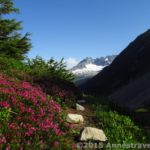
For either trail: Continue along the path as it slowly ascends along with the river. You will be following this river (the Ammonoosuc River) for most of the hike. One of the things to watch out for on the lower sections of the trail is that it is well-laced with tree roots. Watch your footing so that you don’t trip and fall. After a little while, the trail will turn sharply to the left and will cross the stream in front of a very pretty waterfall (Gem Pool). Early in the morning, the sun wasn’t in a good place to get a good picture of the falls, but I snapped a few anyway. The falls would be better in the later afternoon. After the stream crossing, the trail begins to really get steep. You’re also climbing on rocks instead of tree roots. Sometimes there are stairs, but other times you’re just scrambling up and over the rocks. It’s not real hard since you’re not really bouldering, but you will likely have to zigzag from one side of the trail to the other to avoid climbing up over the rocks.

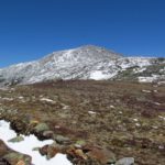
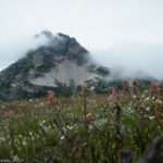
Mount Washington from the trail
All the way up the very steep section, you will be following the stream as it quickly cascades down the mountainside. In a few places, you can see the waterfalls, or take short side trails to the river’s edge. At one point, a sign points down a trail on the right, saying that “The Gorge” is down that trail. Someone has penciled in that it’s 8 miles to the Gorge, but according to another hiker, it’s actually only a few hundred feet, and the view is well worth seeing. We didn’t know this, so we kept going straight on the Ammonoosuc Ravine Trail.
One of the problems we encountered in this section was an increasing amount of snow. Apparently, it had snowed the day before, and the snow hadn’t had a chance to melt yet. So, later in the day, it probably would have been much better, but in the early morning, by the time we reached the tree line, we were walking on a good 2-4 inches of snow. That didn’t make the going any easier! I don’t recommend this trail when it’s snowy, simply because the rocks are so slippery, and the trail is so steep that it’s very difficult to climb, especially in sneakers (we hadn’t anticipated snow—when we left home two days before, there was no snow!) There was even one section where the rocky trail was covered with ice, so the snow and the ice were slippery! Higher up, it was just snow, which was easier to climb than the icy rocks.

Y’think they’ve had some weather???: The sign that points up Mount Monroe
Anyhow, the trail continues to climb up steeply over rocks. The higher you get, the more rocks and less dirt you encounter (in general—remember, the trail above the tree line was covered with snow when I hiked it). You’ve had peek-a-boo views through the trees from time to time, but after you break above the tree line, the views really get great. At about the same time, you’ll pass a series of very pretty little waterfalls. In the snow they were especially nice, although they were facing the wrong direction for good photos at that time of day. You’ll continue to follow the stream for a while, crossing it a couple of times, while you are walking through short pine trees. Then you’ll leave the stream behind, but continue to hike upward through ever-shortening trees. At one point, the trail appears to go left, but actually goes right up a switchback. Here you can watch out for a sign saying you’re entering the Lake of the Clouds area; please don’t camp in here. (So for day hikers, this sign is nice—you’re getting close to the Lake of the Clouds!)
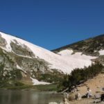
Finally, you’ll break through the trees to be in a place of rocks and grass, but few trees. Keep climbing. After passing through a couple more stands of trees, you’ll come up on the back side of the Lake of the Clouds Hut. Head left around the “hut” (it reminded me more of a lodge than a “hut”) where you’ll encounter a sign pointing towards Mount Washington (1.4 miles away) and Lake of the Clouds. I’d recommend you take the short trail over to Lake of the Clouds, even though it should really be called “Pond of the Clouds” because of its size (or lack of size). It’s pretty, although I suspect it would be crowded in the summer.
 of the Clouds")
Pond (er, Lake) of the Clouds
At this point, we decided that we were too cold and unprepared to climb Mount Washington. The wind was pretty strong, as well, so we headed right across the tundra-like moss and rocks towards a trail that would take us around the back side of Mount Monroe, which we hoped would shield us from the wind. (It did a bit, but we also nearly got blown off our feet a few times—someone told us that there were 80 mph gusts at the weather station on top of Mount Washington). If you’re going to do this and you’ve already seen Lake of the Clouds, go right around Lake of the Clouds Hut instead of left. A sign at the corner of the building will point towards the trail up and the trail around Mount Monroe.
I’ll continue our saga of going around Mount Monroe, Mount Franklin, and over towards Mount Eisenhower and then down the Edmonds Path in the next post. Be on the lookout for it next week!
Stats for the trail thus far:
Round Trip Trail Length: 6.3 miles
Facilities: A map and restrooms at the Ammonoosuc Ravine Trailhead
Fees:$3 a day to park at the Ammonoosuc Ravine Trailhead
Trail 
Road
Signs
Scenery
Would I go 100 miles out of my way for this?
Overall Rating:
This Week’s Featured Product!
Check out this book for so many great hikes in the White Mountains! The book is compiled by the Appalachian Mountain Club.

Pingback: Anne's Travels » Over the Presidential Range
Pingback: The Jewel Trail up Mount Washington: Better than Ammonoosuc Ravine
now in my rss reader
Pingback: Anne's Travels » A Beautiful Waterfall: The Gorge in Ammonoosuc Ravine