
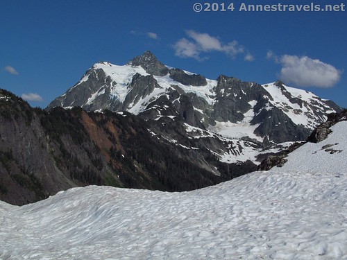
Mt. Shuksan from Artist Point
Artist Point, at the end of the Mount Baker Highway in northwestern Washington, is a very popular place (at least when it’s thawed out – which is about two to four months of the year). Cars drive in and out all day long; some of the owners stay to hike the longer trails or walk the shorter ones, but many stop, get out of their car, take some pictures, and drive away. (Granted, you wouldn’t want to walk – let alone hike – in some of the outfits these drivers are wearing, but you get the point.) The most popular of the trails is the Artist Ridge Trail, a 1.5 mile (2.4 km) (max) RT walk with fabulous views of Mount Baker and Mount Shuksan. Even when it’s snowcovered, plenty of people take the walk or snowshoe along the ridge. It’s well worth the hike, too – the views are incredible the entire way!
Quick Stats
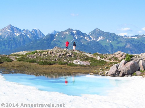
Hikers pause to enjoy the view near a frozen lake on the ridge
We did the Artist Ridge Trail late one afternoon in late July. The snow had melted earlier than usual that year, so the road was clear and so was the parking area (mostly – the snow banks around the restrooms were pretty incredible!) However, from the first, the trail was still snow covered. (A week later, much more of it had melted out – but at the time, all you could see were the footprints leading off along the ridge!) As the trail is popular, though, there were well-defined footprints across the drifts. On a slope near the beginning of the trail, weekend adventurers were sledding. All of us Easterners got a kick out of seeing people sledding in July.
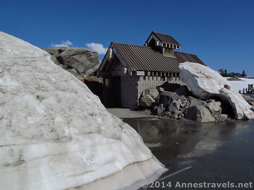
Snow around the restroom
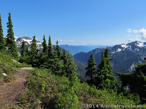
The trail crossed the ridge (passing the observation area that wasn’t visible when I visited), then turned left along the ridgeline. I think sections of the trail were melted, but they were often full of water, and there were large patches of snow between the melted spots, so most hikers found it easier to simply walk on the hard-packed snow along the top of the ridge.
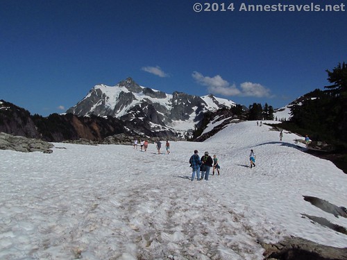
Adventurers on Artist Ridge
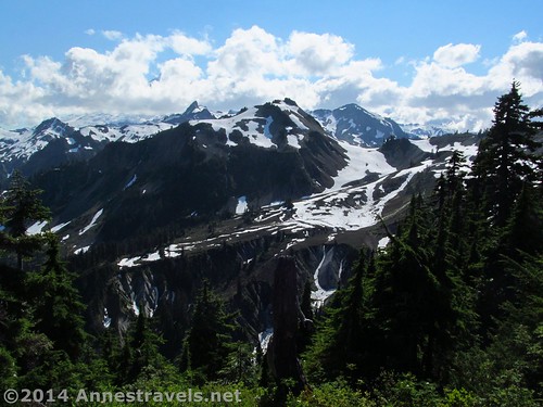
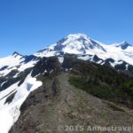
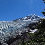
Cresting a small hill, the trail suddenly appeared, with no snow for what seemed like quite a while. How novel! (Ok, not really, but we were beginning to think we were going to hike in snow for the entire hike!) It continued to ascend along the side of the ridge, across several snowfields, through a rock field, and around a small glacial pond, finally topping out on the other side of the ridge. There’s Mt. Shuksan right in front of you: Wow!
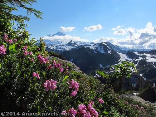
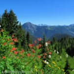
Views along the trail
The trail follows the ridge, almost around its end at 0.6 miles (0.9 km), with fabulous views of Mount Shuksan. From here, the trail gets a bit sketchy. I think it may turn right, with your back now to Shuksan, but there are so many social trails, you can basically take whichever one takes you toward the view of your choice.
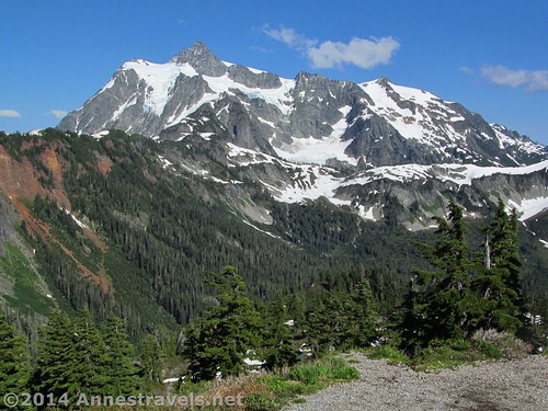
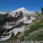
Mt. Shuksan from the end of the ridge
We continued upward, finding a nice view of Mount Baker at 0.75 miles (1.2 km). There are even more social trails up here; we tried to go back the way we’d come, but ended up at another view overlooking a valley at 0.95 miles (1.5 km). Oops. Back to the “trail”.
Mt. Baker views
We did find the trail back (without too much more trouble) and headed back toward the parking area. The Artist Ridge trail may not be very long, but it sure packs a punch when it comes to views!
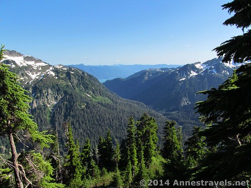
Valley views when we got off the trail
Round Trip Trail Length: Max 1.5 miles (2.4 km). Unless you really feel like hiking lots of social trails.
Lowest Elevation: 5,028 ft. (1,532 m) (parking lot)
Highest Elevation: 5,235 ft. (1,595 m) (Mt. Baker view)
Net Elevation Gain: 207 ft. (63 m)
Facilities: Pit toilets at the parking area. No water is available after the ranger station in Glacier, WA.
Fees: $5/day (must purchase daily pass at the visitor center in Glacier – the machine is open 24 hours). Alternatively, America the Beautiful (Interagency), Senior (Golden Age), Access (Golden Access), Volunteer, Military, and Northwest Forest Service Annual Passes can be displayed. Per the park ranger, leaving your pass number in your windshield is not acceptable and the area is frequented by park rangers who ticket vehicles without passes in their windows (and I’d say frequented isn’t strong enough – there are park rangers even in the middle of the night!) Apparently pass theft isn’t a problem here (we left ours in the window for about a week and never had an issue). Discovery Passes not accepted!

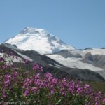
Mt. Shuksan over the frozen lake
Trail 
Road
Signs
Scenery
Would I go 100 miles out of my way for this?
Overall Rating:
Most of the time we were hiking, Mt. Baker looked something like this…
Key GPS Coordinates
Artist Ridge Parking: 48.84643N / -121.69305W (48° 50′ 47.1474″ / -121° 41′ 34.9794″) (5,028ft.; 1,532 m)
Trail beginning: 48.84631N / -121.69494W (48° 50′ 46.716″ / -121° 41′ 41.784″) (5,057ft.; 1,541 m)
Shuksan View: 48.84226N / -121.68549W (48° 50′ 32.136″ / -121° 41′ 7.764″) (5,178ft.; 1,578 m)
Baker View: 48.84255N / -121.68708W (48° 50′ 33.18″ / -121° 41′ 13.4874″) (5,235ft.; 1,595 m)
Valley View: 48.84124N / -121.68643W (48° 50′ 28.4634″ / -121° 41′ 11.148″) (5,164ft.; 1,573 m)
The gpx file for my hike on the Artist Ridge Trail can be downloaded – please note that this and the GPS Coordinates are for reference only and should not be used as a sole resource when hiking this trail.
Download File size: 50.3 KB Downloaded 178 times
(Note: I do my best to ensure that all downloads, the webpage, etc. are virus-free and accurate; however, I cannot be held responsible for any damage that might result, including but not limited to loss of data, damages to hardware, harm to users, from use of files, information, etc. from this website. Thanks!)
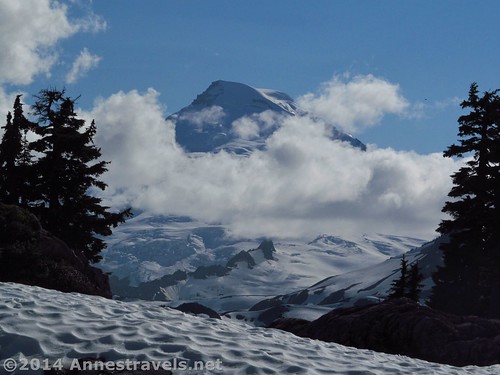
…but sometimes Mt. Baker looked like this!
Getting to the Ptarmigan Ridge Trailhead (Artist Point)
From the Glacier, WA ranger station (the one place you can buy a pass if you need one, get water, and use a flush-toilet restroom – all 24 hours a day), turn right (east) onto WA-542 E (aka the Mount Baker Highway). Drive nearly 24 miles to Artist Point, a large parking lot with a spectacular view at the end of the road. The trail begins on the Mt. Shuksan side of the parking area near the curving stone wall (if it isn’t snow covered). The road is paved the entire way, but it twists and curves through some amazing scenery – and white knuckle experiences – along the way. Also, note that the road is rarely open until July, more often August or sometimes not at all.
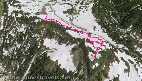
Visual map of the Artist Ridge Trail – up is north
Zoom map out to browse nearby hikes & places of interest
This Week’s Featured Product!
This book covers the area around Mt. Baker in detail as well as other areas of Washington. There’s 30 hikes and descriptions of many more in this book.
Pingback: Anne's Travels » Table Mountain near Mt. Baker
Pingback: 10 of the Best Trails In and Around North Cascades National Park - Anne's Travels
Pingback: 6 Best Hikes on the Mt. Baker Highway - Anne's Travels
Pingback: Pictures of the Lake Ann Trail to Swift Creek