

Some of the switchbacks…!
In the Columbia Gorge is an awesome monolith, considered by some to be the largest in the world next to Gibraltar. Actually, it’s the remains of an old volcanic plug. From most vantage points up and down the Gorge, the rock is visible, a beacon to those navigating the Columbia River, as well as tourists today; thus it’s name, Beacon Rock. However, the coolest thing about this rock is that you can climb to the top without technical gear. Instead of donning ropes and hard helmets, slip on your sneakers and climb the dizzying switchbacking trail up, up, up to the top of the 848-foot high rock. Not for those with a fear of heights, but very cool if you love unique engineering and nice (though not outstanding) views!

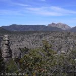
Part of the view from the rock
Getting There
To get to Beacon Rock, you’ll have to go to Beacon Rock State Park. From the east, take WA-14 West 7 miles from the Bridge of the Gods Toll Bridge. If you’re already on the Washington Side, you won’t have to pay the toll; you can just continue on WA-14. However, if you’re coming from Oregon, this is a good place to cross the river (but you will have to pay to go across the bridge—there’s a $1 toll each direction). You will pass the Bonneville Dam (very cool—I’ll cover that in another post) as well as the town of North Bonneville. The parking area for the hike will be on your left near mile post 35.
If you’re coming from the west, you’ll need to cross the river near Portland, or else drive all the way to Bridge of the Gods and come into the park from the east. Near Portland, you can cross the Columbia River into Washington via the Glenn L. Jackson Memorial Bridge (which I don’t believe there’s a toll charged to cross). Take the first exit onto WA-14 East and drive a little over 28 miles to the Rock’s parking area, which is near mile post 35. The parking area is on the river side (right side) of the road. It’s not huge and can fill up quickly—this is a very popular hike!

Near the bottom of the rock
Background
Beacon Rock has been a landmark for travelers for many centuries. The Indians who lived in the area used it for hundreds of years as a marker of the last set of rapids before the ocean, 150 miles to the west. Lewis and Clark also saw it on their trek to the Pacific Ocean, and while camped at its base noted its location in their journal in 1805, calling it “Beacon Rock.” In 1811, Alexander Ross of the John Jacob Astor expedition named the rock “Inshoack Castle”. From then on, locals called it “Castle Rock” until the United States Board of Geographic Names officially renamed the monolith “Beacon Rock” in 1961. Meanwhile, Henry J. Biddle purchased the rock in the early 1900s, intending to build a trail to the top. Between 1916 and 1918, Biddle constructed the trail we still use today, a maze of twisting switchbacks and railings that finally lead travelers to the top of the monolith. The rock was incorporated into a state park in 1935, when Biddle’s heirs turned it over to the state. A map of the state park can be found at
http://www.parks.wa.gov/parks/thumbnailAndmaps/4150042.pdf.

A barge on the Columbia River
The Hike
Today, a small parking area is located on the southern (river) side of WA-14. There is a $10 daily entrance fee charged to do anything in the park, including climb the rock. There are signboards and other information (including a payment kiosk) at the parking area. The trail itself is not hard in the beginning, as it goes through the forest to the south (river) side of Beacon Rock. Then the trail begins to ascend the sheer face of the monolith. Biddle did his job well; it’s not a hard hike for all the climbing you’re doing. The real fun is enjoying all the switchbacks. There are plenty of guardrails which have been changed and reinforced throughout the years. Still, if you’re terribly afraid of heights, this probably isn’t the trail for you. Also, although it’s a fine hike to do with children (we had four under the age of 12), it would be a very good idea to keep the children close to you, since it would be a long way down. The railings themselves are made of Kee Klamp. One member of my group works for a company that sells this railing, so he got the company to put it on their blog: A Railing on the Side of a Mountain – Kee Klamp Railing

Hiking up
Along the way, you’ll get some nice views, especially at the ends of switchbacks. From here you can see the Columbia River, especially up and down the river and the hills in Oregon on the other side. After about a mile of hiking, you will finally reach the summit. I don’t recall there being terrific views (there were a lot of trees), although they were nice enough: the Columbia River and some surrounding mountains. The viewing area at the top is fairly small, so if there are a lot of people, this would get crowded quickly. Return by the way you came…I don’t know, but it seemed like those drops are a lot longer on the way down than on the way up…but maybe I imagined it?

A catwalk about half way up
Beacon Rock is a great short dayhike for those who love heights, enjoy an adventure, or like exploring engineering masterpieces. I’d highly recommend it if you’re in the Columbia Gorge area.
Round Trip Trail Length: 2.2 miles
Facilities: Restrooms and signs at the trailhead
Fees: $10 per day entrance fee to Beacon Rock State Park. Discovery and Beacon Rock Annual passes also accepted.
Trail 
Road
Signs
Scenery
Would I go 100 miles out of my way for this?
Overall Rating:
This Week’s Featured Product!
“Day Hiking Columbia River Gorge” is a great book for those who want to bring a book with them while hiking. It’s also great for those who are planning a trip to the Columbia Gorge area. The book covers Portland/Vancouver metro areas, Silver Star, Scenic Area, Trapper Creek Wilderness, and the entire Columbia Gorge (including The Dalles). I especially like the maps and black-and-white pictures of the different trails.

Hello my friend! I want to say that this post is awesome, nice written and all vital infos. I would like to look more posts like this .
Pingback: Anne's Travels » Link Roundup: My Favorite Hiking Websites
Pingback: Terrifying Trails of the Western US - Anne's Travels