

Along the Peek-a-Boo Loop
I’ve hiked in Bryce Canyon several times, but on our last visit, it had been several years since we’d visited. I’m not sure if it was because we thought we’d done everything Bryce has to offer (far from it—there are still things we’re looking forward to doing for the first time), or if it was just snowed in every time we thought about going there. Anyhow, it had been a while, but we wanted to do a trail we remembered as especially nice: the Peek-a-Boo Loop. We actually ended up only doing half of the loop, in part due to a map we had that had faulty trail mileages, but I’d defiantly do that hike again. We started at the rim, got awe-inspiring views of the canyon, then hiked down in and among the formations. By the time we were on the Peek-a-Boo Loop, there were more great views of ridges of brightly-colored sandstone formations. Then, we climbed back up through Wall Street, with the tallest of the formations right above our heads. At only 3.1 miles in length, it was well worth the effort, and I’m sure we’d all do it again without a second thought.
We parked at Bryce Point. This is also a shuttle stop, so you could alternatively ride the shuttle to this point. We actually arrived before the shuttles were running, so we simply drove up to the point, parked, and got ready to hit the trail. The trail itself starts at the far end of the parking area; if you come by the shuttle, that’s back the way that the shuttle came from. You will want to head towards the Peek-a-Boo Trail, although you won’t be on that for a while. This trail goes right almost immediately after you leave the parking area. Keep following the signs for Peek-a-Boo. I’m sorry that I don’t recall the name of the trail you will be following; I know you will follow the Under-the-Rim Trail for a while, until it goes off towards the Hat Shop (not the way you want to go).

Not far down the trail
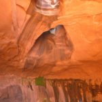
The views along the trail are magnificent, although you may not notice this immediately. In some ways, the farther down you get, the better the views are, and the steeper the trail gets: you will be going downhill right up to the point where this trail intersects the Peek-a-Boo Loop. At one point, you will get to walk through an archway that has been carved in a formation (the trail actually goes through the ridge). Getting a picture of the hoodoos on the other side of the canyon through this arch makes for some very beautiful pictures. Oh, and by the way, in mid-May there was still some snow left on the trail. It was quite passable, but be aware that there can be snow well into May (the day we left, it snowed quite hard, I heard later).
After 1.1 miles, you will come to the junction with the Peek-a-Boo trail. This trail is a loop; you will eventually have to make a choice: do you want to do the entire loop (3 miles) and then hike back up to Bryce Point, or would you rather hike half of the loop, take the Navajo or Queen’s Garden trails back up to the rim, and then take the shuttle back to your vehicle? The choice is up to you, but we decided on the second option. So, we turned right down the Peek-a-Boo Trail, and headed into the heart of the formations.

Through the arch
The reason we turned right is that we’d hiked the entire Peek-a-Boo trail several years earlier, and we remembered the “right” section as being the prettier of the two halves of the loop. I’m sure the other side is quite nice too, and there were certainly some “boring” sections of the “right” side of the loop, but later on we were rewarded with some pretty stunning views.
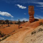
The trail continues to descend for a short while, although it is quite a bit flatter than the trail you were just on, and then becomes rolling, going slightly up and slightly back down again. It’s not a hard hike, and you can go fairly quickly because there aren’t a lot of views in this area. In some places you’re in a pine forest, so of course you can’t see much, but you are at the bottom of some of the towers, which is interesting. Then, quite suddenly, you will come out of the trees and begin to climb uphill. This is where the views start getting really nice. The higher you climb, the more you can see of the hoodoos, spires, and pretty ridges that surround you. It’s almost like being in a fantastic new set of badlands, except that there are as many spires as badlands, in colors of red, orange, and yellow. Beautiful!

Pretty Formations
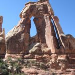
Near the top of this climb is a small arch to walk through. On either side of this arch is, in my opinion, the very best of the views. You can see far away to the canyon rim, as well as ridges of closer hoodoos. You’re even walking right underneath some hoodoos! Keep walking along the trail as it continues to ascend and then descend to a junction with the horse trail. We skipped the horse trail, as well as the rest of the Peek-a-Boo loop, and headed on towards the Navajo and Queen’s Garden trails.
At a nearby junction, you can choose whether you want to take the south side of the Navajo Trail, the north side of the Navajo Trail, or the Queen’s Garden Trail. If you’ve never done any of these, I’d recommend the Queen’s Garden Trail, simply because of the terrific views (the mileages are quite similar no matter which you decide to take, although the Queen’s Garden is a little longer—I think the south Navajo is 0.7 miles, the north Navajo, 0.6 miles, and the Queen’s Garden, 1.5 miles). I also enjoy going to the Queen’s Garden and seeing the formation called “Queen Victoria”—it really looks like a queen! We’d done the Queen’s Garden Trail the last time we’d gone to Bryce (in April—they’d just gotten a couple inches of snow!), and the north side of the Navajo Trail was closed, so we went up the south side of the Navajo Trail.

Beautiful view of the canyon
This trail is nice enough, although nowhere near as nice as the Peek-a-Boo. However, after a few tenths of a mile, you will come to the exciting part: Wall Street. Here the hoodoo spires are very, very tall, and loom up above the trail, almost touching each other a hundred feet or more above you head. Because of the chance of falling rocks, the trail may be closed at any time, and the park service has signs up reminding you that you are taking all of the liability for yourself if a rock falls on you. However, this shouldn’t dissuade you. Keep walking up the steps, and then start ascending the switchbacks. These go almost straight up the side of the canyon, and seem almost like they’ll never end. However, they aren’t terribly steep, so we made it up without too much trouble.
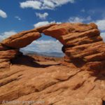
Not long after this, you will come up to the parking area (Sunset Point). From here, you can catch a shuttle bus back to the visitor center, from which you can catch a different shuttle back to Bryce Point. Alternatively, you could walk the Rim Trail for about 2 miles back to Bryce Point. We opted for the shuttle, and then walked out to Bryce Point before getting into our vehicle. The views from here are also incredibly beautiful, so I highly recommend that you do this, either when you start or when you come back to your vehicle.

The view from Bryce Point
I highly recommend that you download the map of this area from the national park website at: http://www.nps.gov/brca/planyourvisit/upload/Bryce_Amp_summer-web.pdf
Fees: $25 per private vehicle; good 7 days. Bryce Canyon National Park Annual, Interagency, Golden Age (Senior), and Golden Access (Access) Passes are also accepted
Trail 
Road
Signs
Scenery
Would I go 100 miles out of my way for this?
Overall Rating:
This Week’s Featured Product!
There’s more than 50 hikes in this guide, which covers Bryce Canyon and the surrounding region. It’s a great resource when you’re hiking in the area.


Hi there. I enjoyed this article . It was informative.
best of luck to you
Pingback: Anne's Travels » Fairyland Trail Loop: A Long, Lovely Bryce Hike
Pingback: Anne's Travels » Queens Garden Trail & Navajo Loop: So Many Hoodoos!
Pingback: Anne's Travels » Link Roundup: My Favorite Hiking Websites
Pingback: Angel’s Landing: Best Views in Zion National Park - Anne's Travels
Pingback: 15 of the Best Day Hikes in Southern Utah - Anne's Travels