
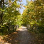
Bicycling the Genesee Valley Greenway just north of Mount Morris, New York
This summer we’ve been doing daytrips closer to home. That’s not to say we won’t be taking a longer trip, as well, but it’s been a lot of fun to travel in our own neighborhood. One highlight was definitely biking the Genesee Valley Greenway from Mt. Morris to the Brookdale Preserve (south of Rochester, NY). It was almost exactly a 30 mile ride, which is very long for us, but I think we all enjoyed it. The trail is quite well-groomed and flat, sometimes shaded, sometimes passing through agricultural New York. The only negatives were the bugs (where were fine as long as we didn’t stop too long) and one section of the trail which was closed. However, the later rerouted us through some lovely scenery, so I can’t complain. On the positive side, we got to follow the remains of an old canal, ride across the Genesee River, see an old canal lock, stand on a train trestle, ride under I-90, follow the Genesee about 30 ft. above the river, see the site of an old Indian village…all in a peaceful setting. Pretty good by me!
Quick Stats
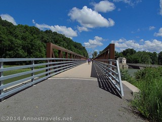
The bridge over the Genesee River in Mount Morris
We didn’t exactly get an early start one day in July. We’d all been up very late a couple nights before and I guess we were still catching up on sleep. Add to that we were trying to print out one last map for the ride, and it simply wouldn’t go through the mail system…you get the idea. Then we had to drive 1.5 hours down to Mt. Morris. So we didn’t even begin until after 11am. The good news was that there was a nice parking area for us to unload the bicycles (I’ve included the GPS coordinates for all the parking areas along the route at the bottom of this post). Two members of the group weren’t real excited about biking, so they agreed to follow us in the van, park wherever they could, and then walk to meet us along the way. It worked pretty well, except in the closed section…but more on that later 🙂
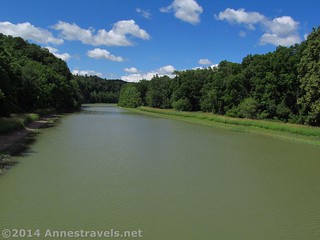
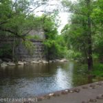
The Genesee River in Mount Morris
The trail through Mt. Morris (starting at State Street) is quite rough (bumpy) and has the only real hill on the route (other than a few hills to cross roads). It passes behind some old buildings (probably left over from the railroad days), then climbs a hill to the sidewalk, then fairly quickly crosses a busy road (Rt. 36). There are definitely some nice things about New Jersey that you don’t see in New York: In New Jersey, cars stop for bicycles waiting by a crosswalk, but in New York, you can wait 5 minutes for all the cars to stop streaking by (or hope a non-local stops for you!) If you’re not sure where to go, watch for the green hiking signs and the “Genesee Valley Greenway” sings (which seem to be everywhere).
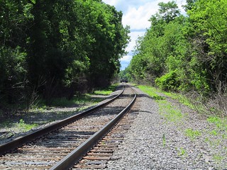
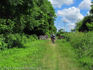
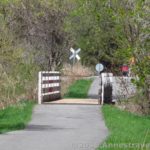
The real train tracks we had to cross just north of Mount Morris
From here, the trail enters the forest for a short distance, then crosses the Genesee River. A parking area is located on the other side; near the parking area, you will need to cross Rt. 36 again. Be patient; you probably won’t ever have to wait that long to cross any other road on the route, at least not for quite some time. The trail on the other side of Rt. 36 doesn’t go far before it comes to a set of real railroad tracks. Look both ways, then pick up your bicycle and walk it across the tracks.
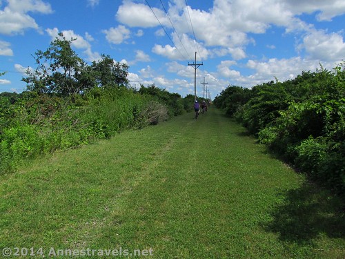
Then the excitement calms down a bit. The trail is wide and grassy; in some places, three or four bicycles could ride abreast (for most of the trail, two could comfortably ride abreast, although we usually went single-file). On either side of the trail are hills and fields, although there isn’t much in the line of views due to the bushes. We crossed several roads without incident (these roads are so small they don’t even have a center stripe…or they’re farm driveways). Signs usually indicate when a road is coming with “stop ahead” and then the name of the road painted on the gates that keep motorized vehicles off the rail trail.
North of Mount Morris
The next bit of excitement (if you can call it that) came at 7.0 miles when we crossed Chandler Road. Here we found the site of an old Indian village, or at least a marker stating that the village was once here. There was also a picnic table, so even though there wasn’t any real parking, everyone (including the drivers – who had most of the food) gathered around for lunch, since it was almost 12:30pm.
We started again about 1pm. Since the next road (Rt. 63) wasn’t too far away (though it does have a parking area), the drivers decided they’d meet us at the next parking area – at the end of York Landing. The trail was good, shady, and cool, but after crossing Rt. 63, we found orange fencing completely blocking the trail. Trail closed? What for? Now what to do?
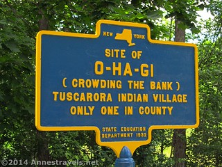
The sign for the O-Ha-Gi Tuscarora Indian Village Site
Now was when I was thankful we had taken the time to print the maps that morning. We turned west on Rt. 63, then, after almost half a mile, took a right onto River Road. This was the most beautiful section we bicycled that day, through fields, by an abbey and generally feeling as close to touching the puffy clouds in the sky as you can get in New York. Rt. 63 had a pretty good shoulder lane, and River Road was very lightly traveled, so we didn’t run into any trouble that way (which was a good thing since for some of our younger riders this was their first trek bicycling on a road!)
Fields along River Road
After another 2.7 miles, we turned down York Landing (apparently there was a dirt road we could have turned down (so said the drivers, who had walked past it on the trail), but we weren’t sure if it would take us to the trail or if it was private property, so we opted to go down to the paved York Landing). This was fun, as the dead end road is simply one long hill to a parking area with an interesting sign kiosk next to the Genesee Valley Greenway. Biking down, I was happy to later discovered I’d gotten up to an unprecedented 25mph 🙂
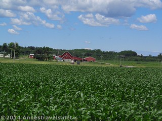
A rural farm from York Landing Road
Now we were in another quandary. There sat the van, empty, and our drivers nowhere to be seen. We knew they’d be ok without us, but we also knew they’d worry if we didn’t show up. This side also had the “trail closed” sign and fence, but someone had cut the fence making it possible to enter the trail from this end. The other direction was open for recreationalists. We all refilled our water bottles from the supply we’d left in the van, then decided to leave a note under the windshield wiper saying where we’d gone (continuing up the trail). However, before I could finish writing, a group member finally was able to make contact through our walkie-talkies with the drivers (they were out of range when we first arrived). They’d walked up the closed trail figuring they might find us…
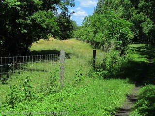
Fence along the trail. Not long after this, the canal began to follow the old railroad line.
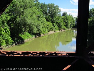
We continued northward through one of the most interesting sections of the Genesee Valley Greenway (to me). On the left side of the trail, from now nearly up to Rochester, are the remains of an old canal (probably the Genesee Valley Canal). However, as we kept riding, the land sloped away on our right until I could see the Genesee River some 20-30 ft. below us. Wow! It’s peek-a-boo, through the trees, but it’s amazing to be riding that high above the gully. The trail through this section was slightly wet, but since we’d had rain the day before, I suppose it was to be expected.
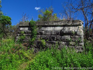
Old railroad abutment along the trail (this was the first one, maybe 0.25 miles before the Lehigh Valley Trail)
We met up with the drivers at Fowlerville Road (where there was a parking area and a portable rustic restroom) and continued north. From here, there really isn’t anything too exciting – just forests, fields, and streams, with the canal on the left most of the time – until the section just south of the Lehigh Valley Trail (north of Rt. 5). Here the trail passes by a marsh (yes, the bugs are terrible) then past an abutment that probably once held train tracks over the Genesee Valley Railway. A short distance further, there is a second abutment. This second stone structure once carried the Lehigh Valley Line; the Lehigh Valley Trail crosses directly after the abutment. At the crossing are a few picnic tables and an informational sign. I highly recommend that you turn right here to the trestle spanning the Genesee River. It’s just plain cool.
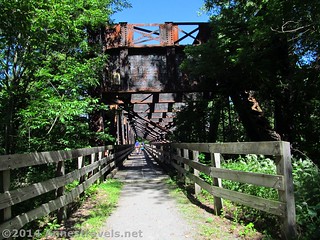
The trestle on the Lehigh Valley Trail
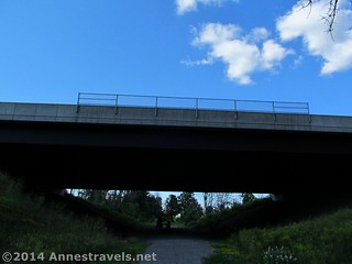
Returning to the Genesee Valley Greenway, we had only 5 miles more to go to reach I-90. The trail passes among fields, with occasional good views, before entering Canawaugus Park at mile 25.8. Shortly after the park (which has an old train bridge across an old canal filled with water), the trail crosses North Road, another tricky crossing due to the number of cars. From the park, it’s only another 2 miles to the I-90 crossing. I had been led to believe that the crossing was an old tunnel; however, it’s just an overpass. Still, walking under an interstate – let alone an interstate from coast to coast that I’ve driven every part of – doesn’t happen every day, and we all enjoyed a few minutes listening to the trucks and cars zoom over our heads.
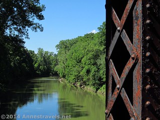
The Genesee River from the Trestle
It was then a final push toward the van. Some of us were getting tired (which wasn’t surprising, given we’d been on the trail over 6 hours). Still, I wanted to make it an even 30 miles, so when we came to Morgan Road, I convinced the drivers to pick us up at the next road (which turned out to be at the Brookdale Preserve). I’m so glad we did those extra two miles. Not only were there fields all around us, but at 29.8 miles we came across an old lock (Lock #2). That was interesting, and so was the informational sign nearby (which starts out something like, “All the locks on the canal should have been built like Lock #2…”)
Brookdale Preserve is just off the trail; you can either take the not-very-busy road or take one of the mown trails to the parking area. This parking area is quite large; it would be a great place to start from if you didn’t have a shuttle vehicle (like we did) because there is plenty of space to unload your bicycles and other gear. There are also a few picnic tables in the Brookdale Preserve.
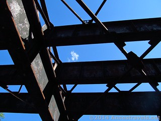
Looking up at the girders where the trains used to go over the Genesee River (we were on the “lower deck”)
Overall, I’m so glad we did it! We enjoyed ourselves, and the scenery was serene if not stunning. If I did it again, I’d probably start slightly closer to Rochester, but, hay, crossing the Genesee the first time was fun, too!
Round Trip Trail Length: As long as you make it. We did 30 miles with a shuttle vehicle.
Starting Elevation: 600 ft.
Ending Elevation: 523 ft.
Net Elevation Gain / Loss: About 25 ft. (total would be closer to 100 ft.)
Facilities: Very few on the trail itself; there are restaurants in the towns and one port-a-potti in one of the parking lots.
Fees: None
Trail 
Road
Signs
Scenery
Would I go 100 miles out of my way for this?
Overall Rating:
Key GPS Coordinates for the Genesee Valley Greenway
Looking upriver at the Genesee River from the train trestle
Mount Morris Parking off of State Street: 42.72614N / -077.87244W (42° 43′ 34.104″ / -77° 52′ 20.7834″) (750 ft.) – Shared parking area with apartments. Would have felt bad unloading too early in the morning, but since it was 11am, I just tried to keep the noise down for the residents’ sakes. (0.0)
Mount Morris Parking #2 (near Genesee River): 42.73951N / -077.88235W (42° 44′ 22.236″ / -77° 52′ 56.46″) (598 ft.) – Medium-size parking area located just after the trail crosses the Genesee River on a substantial bridge. (1.25)
US-20A parking 42.77721N / -077.87035W (42° 46′ 37.9554″ / -77° 52′ 13.26″) (574 ft.) – Medium-size parking area. (3.9)
Chandler Road / O Ha Gi Indian Village Site: 42.81823N / -077.85181W (42° 49′ 5.6274″ / -77° 51′ 6.516″) (602 ft.) – no dedicated parking, but a picnic table was next to the historical marker sign. (7.0)
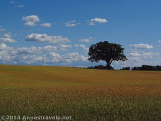
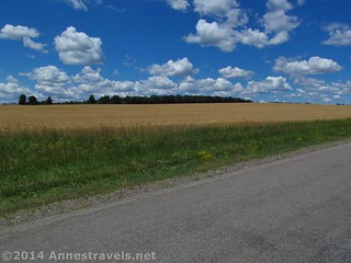
One of my favorite pictures I took that day: Wheat Fields south of Rochester
State Route 63: 42.82820N / -077.85086W (42° 49′ 41.52″ / -77° 51′ 3.0954″) (573 ft.) – parking shared with a restaurant. Here the trail was closed, so we had to skirt the closure via the road to York Landing. Comparing the map to my GPS reading, taking the road added about 1.5 miles to my mileage from here to the end. (6.8)
York Landing: 42.86452N / -077.85101W (42° 51′ 52.2714″ / -77° 51′ 3.636″) (568 ft.) – large parking area at the end of a small road. Informational kiosk with interesting info about the area. (11.3)
Parking at Fowlerville Road: 42.89148N / -077.82372W (42° 53′ 29.328″ / -77° 49′ 25.3914″) (582 ft.) – small parking area with a port-a-potty. (13.9)
Telephone Road parking: 42.91816N / -077.78402W (42° 55′ 5.376″ / -77° 47′ 2.4714″) (579 ft.) – large parking area. Busier than normal road crossing, but not bad. (17.3)
The I-90 overpass
Lehigh Valley Trail trestle: 42.98449N / -077.73176W (42° 59′ 4.164″ / -77° 43′ 54.3354″) (585 ft.) – Very cool train bridge. You are actually on the lower deck; the train would have passed across the bridge on the girders above you. (23.0)
Canawaugus Park: 43.01901N / -077.74683W (43° 1′ 8.436″ / 77° 44′ 48.588″) (556 ft.) – Nice parking area, picnic tables, etc. (25.8)
I-90 underpass: 43.04385N / -077.73261W (43° 2′ 37.8594″ / -77° 43′ 57.3954″) (562 ft.) – Just an every-day, typical underpass such as you’d see on any given interstate. Still cool to know that there might be a truck from Seattle rumbling over your head. (27.8)
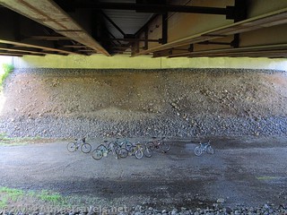
Our bicycles under the I-90 overpass
Morgan Road: 43.05023N / -077.72854W (43° 3′ 0.8274″ / -77° 43′ 42.7434″) (530 ft.) – No real parking area, but there is a place to pull off the road. (28.4)
Lock #2: 43.06754N / -077.71814W (43° 4′ 3.144″ / -77° 43′ 5.304″) (527 ft.) – Genesee Valley Canal lock & interpretive sign. (29.8)
Brookdale Preserve Parking: 43.07719N / -077.70943W (43° 4′ 37.884″ / -77° 42′ 33.9474″) (523 ft.) – Large parking area with picnic tables. (30.8)
The gpx file for the Genesee Valley Greenway can be downloaded – please note that this and the GPS Coordinates are for reference only and should not be used as a sole resource when hiking this trail.
Download File size: 230.3 KB Downloaded 140 times
(Note: I do my best to ensure that all downloads, the webpage, etc. are virus-free and accurate; however, I cannot be held responsible for any damage that might result, including but not limited to loss of data, damages to hardware, harm to users, from use of files, information, etc. from this website. Thanks!)
Getting to the Genesee Valley Greenway:
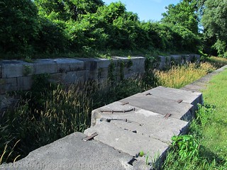
Lock #2 on the old Genesee Valley Canal
We parked at the State Street Parking in Mount Morris, NY. To get there, take Exit 7 off of I-390 and head toward the town of Mount Morris, following the signs for the Mount Morris Dam and Letchworth State Park (if you’re coming from I-90, you’ll want to go south on I-390 at Exit 46 to get here). Drive 1.7 miles; the parking area will be on the left just before Genesee Street just before entering the middle of town. The trail crosses the road and then continues behind the buildings.
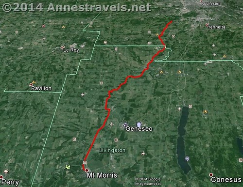
Visual map of the Genesee Valley Greenway from Mount Morris to the Brookdale Preserve, just south of Rochester, New York.
Helpful Downloads
This map was invaluable to me (it’s also semi-official with mile markers and some of the parking areas marked). It says GPS file, but it’s really a pdf.
DownloadZoom map out to browse nearby hikes & places of interest
This Week’s Featured Product!
If you’re looking for rail trails in New York, Pennsylvania, or New Jersey, this is the book to get. With descriptions of the routes, mileages, and decent maps, it’s a real help when deciding which trail to take, as well as on the trail.
[forecast location=”Avon, NY” caption=”Weather for the Genesee Valley Greenway” measurement=’F’ todaylabel=”Today” datelabel=”date(‘D M d’)” highlow=’%%high%%°/%%low%%°’ numdays=”5″ iconset=”Default”]
Pingback: Genesee Riverway and Erie Canal Path: History via Bikes
Pingback: Anne's Travels » Biking the Auburn Trail / Lehigh Valley Trail
Pingback: The Glory of the Lord Covers the Earth - Anne's Travels