
The monument marking the highest point in Oklahoma
Some “highest points” are impressive, and others are not. Some seem to have nothing interesting to recommend them, and some have very nice scenery around them. Black Mesa, the highest point in the state of Oklahoma, isn’t exactly impressive, but it does have nice scenery. Black cliffs and buttes can be seen for quite a bit of the hike, reminding me of Palo Duro State Park. You are fairly high above the surrounding area, so the views are nice from that angle, too. The hike itself is not quite 9 miles (about 14 km) (RT), but it’s not a difficult hike (I did it in about 4 hours, and that included about an hour of lounging around/exploring on top of the mesa). I highly recommend it if you’re in the area on a nice day (you wouldn’t want to be on top of the mesa during a thunderstorm!)

Near the beginning of the trail
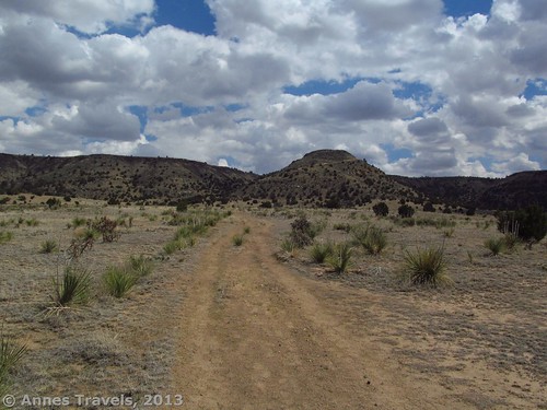
It was a lovely day when we arrived at the Black Mesa parking area, if later than we’d wanted to arrive (that’s what I get for making sure the GPS doesn’t take us on dirt roads – lesson learned!). There were clouds in the sky, but the thunderstorms predicted didn’t seem to be likely. So, we loaded up our gear (snacks, sunscreen, binoculars, and plenty of water) and started down the trail, which begins behind the signboard. A green, metal arrow on the top of a post showed the way.
The trail suddenly turns at the 2-mile mark toward Black Mesa – note the “scar” on the hill you’ll soon be climbing!
The trail begins fairly flat and sandy. Before long, you will pass what looks like what was once a windmill (my guess – you really can’t tell what it is). According to my GPS, this is a spring of some sort – this is also where I began my GPS track. Keep walking along the track, following the arrows if necessary. However, the trial is well-defined and is not difficult to follow. The trail itself used to be a road, so it is fairly wide with two (or more) ruts that are easy to walk in. Actually, the trail is so wide that two or three (and sometimes four or even five) can walk abreast – this is nice for having a conversation while walking. The trail is quite straight for the first two miles (3.2 km). The miles along the trail are marked by benches with “Mile 1”, “Mile 2”, etc. carved on the benches; this helps keep track of how far you’ve walked.
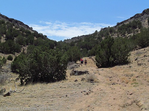
Starting up the switchbacks
At the two-mile mark, the trail suddenly turns left sharply. Ahead of you will now be a hill (or a butte sticking off of the mesa you’ve been following on your left for the entire trail). You can see a “scar” on the hillside where the trail will be in another mile (1.6 km) or so – but don’t get discouraged yet! The next mile (1.6 km) is uphill, but it’s not horrible (and you’re not even at 5,000ft (1,500 m) above sea level)!
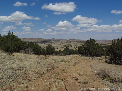
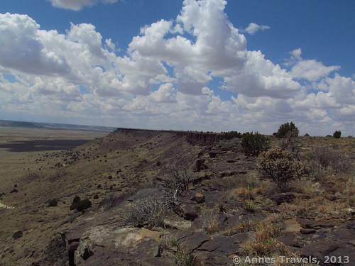
Looking back at the scenery from the switchbacks
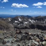
The trail soon begins to climb upward and then to ascend the hill via a switchback. The trail here is rougher and doesn’t have the wheel ruts of the earlier trail. Watch your step and you should be fine – we found it much more difficult to go down (because of slipping on the stones) than to go up. However, as you’re climbing, don’t forget to catch your breath for a minute and look at the view. Although you could see pretty buttes, etc., from the lower part of the trail, here you can begin to a nice overall view, and the views get better as you climb. When you reach the “scar” you will find the Mile 3 bench; keep walking as the trail goes around the hill, up another steep section, and then through a gate and onto the top of the mesa. Congratulations! You’ve ascended Black Mesa!
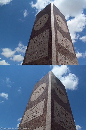
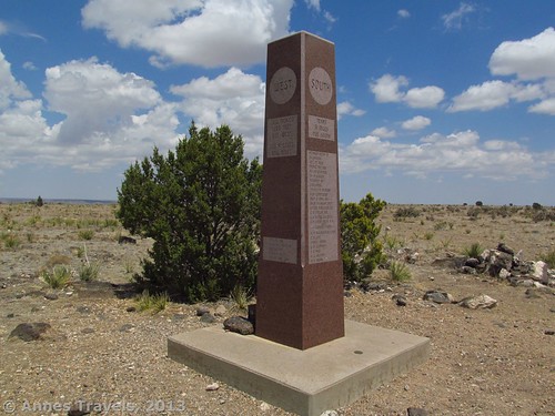
The monument on the Oklahoma High Point
Keep walking along the well-defined trail through the sage brush and then a teddy-bear cholla forest. After another mile (1.6 km) or so you will suddenly come upon an obelisk sticking up next to a tree. This marks the official highest point in Oklahoma, 4,972 feet (1,424 m) above sea level!
The obelisk has been carved with the distances to each state north, south, east, and west of the High Point, as well as some other interesting information. One of my favorite engravings showed the highest point in Oklahoma and the lowest point in the state – on diagonally opposite ends of the state from each other! A bench sits near the obelisk, and a register box is on one side of the monument.
I’d read on the trail map at the trailhead that there was an overlook near the highest point. Three trails go off from the obelisk area: the one you came on, one that heads toward New Mexico (which is only a couple thousand feet away (600 m)) and one that goes south and begins next to the stone bench. We took the one near the bench, which (after a hundred feet (30 m) or so) led us to a view overlooking some of the nearby farmland. It was a good place to have a snack (and much more impressive than the area around the obelisk). There are also some nice, black rocks to sit on. The following video was taken on these rocks.
If you’re in the mood for another nice view, head right along the edge of the mesa (not too close!) and you’ll come to a great view of the black cliffs that give Black Mesa its name. This is fairly impressive, and made a good “turn around” point for us. As we wandered back toward the obelisk, I think we walked just slightly into New Mexico – but I’m not sure 🙂
Return by the way you came. Although not a place you’d probably want to spend a lot of time, it was a nice way to spend a few hours – and now I can say I’ve been on the highest point of another state!
Key GPS Coordinates for Black Mesa
Cliffs along Black Mesa
Black Mesa Parking Area: 36.957203N / -102.957111W (36N 57’ 25.9302” / -102W 57’ 25.599”)
Beginning of switchbacks: 36.94672N / 102.98884W
Top of switchbacks: 36.94225N / 102.98873W
Highest point in Oklahoma: 36.93190N / 102.99784W
Black Mesa south viewpoint: 36.92959N / 102.99754W
Cliff views: 36.92995N / 102.99952W
The gpx file for the Black Mesa Highpoint Trail can be downloaded (out and back) – please note that this is for reference only and should not be used as a sole resource when hiking this trail.
Download GPS File File size: 62.7 KB Downloaded 150 times
Download GPS File File size: 86.5 KB Downloaded 158 times
(Note: I do my best to ensure that all downloads, the webpage, etc. are virus-free and accurate; however, I cannot be held responsible for any damage that might result, including but not limited to loss of data, damages to hardware, harm to users, from use of files, information, etc. from this website. Thanks!)
Getting to Black Mesa
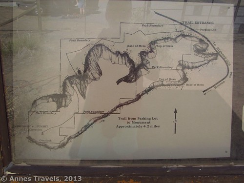
Map of Black Mesa State Park and the trail to the Highest Point in Oklahoma
From the town of Kenton, Oklahoma drive 0.5 miles (0.8 km) east to a road on the left (right if you’re coming from the east) that is marked for Colorado, Black Mesa Preserve, and Black Mesa Summit. Take this road 4.9 miles (7.8 km) to the parking area on your left. A sign states that the Black Mesa Preserve is in the parking lot. There is an ornate gate here and a signboard. One of the nice things about the road to the trailhead is that it’s very scenic (if a bit rough). A motorcycle rally was happening in Kenton the day we hiked Black Mesa, and many of them took this road just because it was so pretty.
Round Trip Trail Length: 8.8 miles (14.1 km)
Facilities: Primitive restrooms at the trailhead (no overnight camping allowed)
Fees: None
Trail 
Road
Signs
Scenery
Would I go 100 miles out of my way for this?
Overall Rating:
This Week’s Featured Product!
Looking to hike in Oklahoma? This is one of the few state-wide hiking books available. It’s a good resource, though: even native Okies say they enjoy the book because it has more hikes in it than they’d heard about.

Pingback: 9 Reasons I Wear Hiking Boots instead of Sneakers