
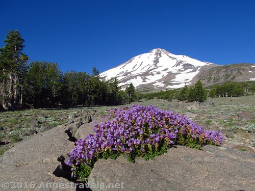
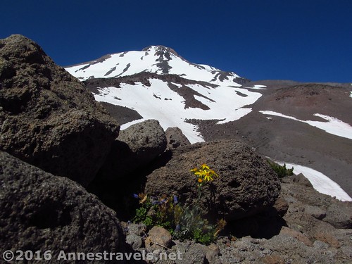
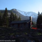
Wildflowers in a rock along the Brewer Creek Trail below Mt. Shasta
I’m convinced that most of Mt. Shasta’s trails aren’t trails at all, but rather routes that more or less might take you to someplace that might be exciting to be. Maybe it was just the directions I had, but they’d talk about landmarks definitely, and I’d miss the landmarks all together, because they looked just like the rest of the landscape. But then again, I think the directions did the best they could considering the situation.
Quick Stats
Views from Butte 9000 of Mt. Shasta’s cone
At any rate, our trek along the Brewer Creek Trail ended us up someplace I don’t think the author ever intended, yet was so strikingly awe-inspiring I can’t imagine why anyone wouldn’t want to do it (assuming they had a spirit of adventure, were in good condition, and had a good GPS or map to get them back to the parking area if they got lost). Think Shasta’s peak soaring high above rugged rock-filled valleys, ridges, and buttes; wildflowers in season; views over lower mountains even to Mt. Lassen (if it’s clear – it wasn’t when I visited); artistically stunted trees; and long stretches of nothing but rocks to get in the way of the views.
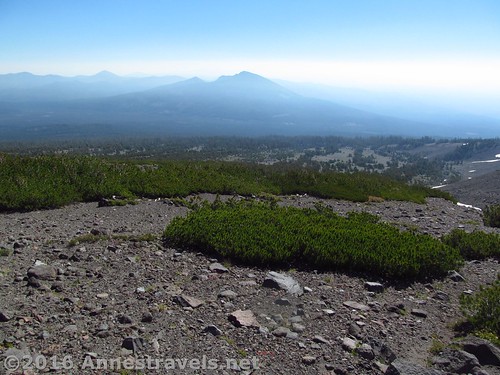
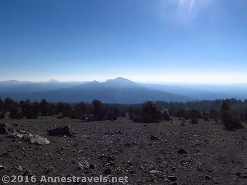
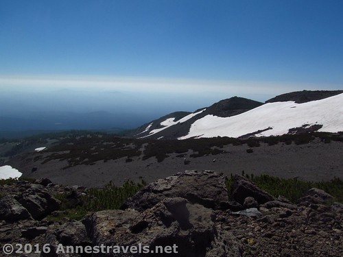
Views of other nearby peaks from part way up the social trail
Really, it’s a View Junkie’s Paradise.
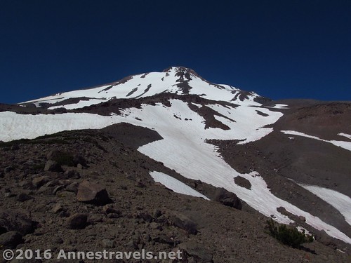
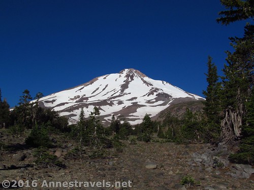
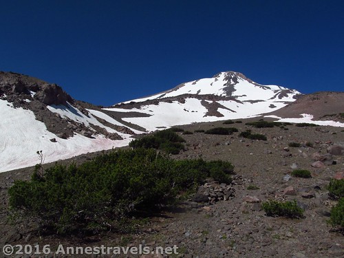
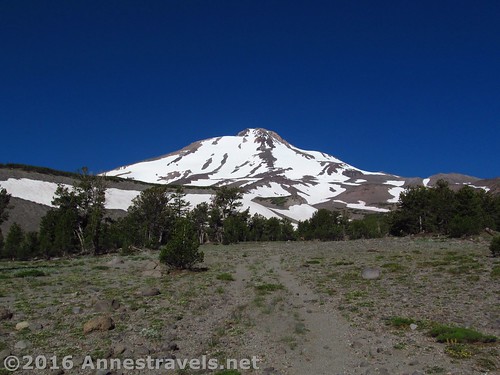
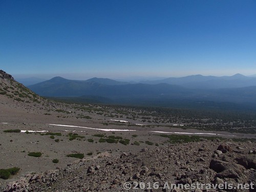
Above the Brewer Creek Trail but not yet to the scree, with Mt. Shasta dominating the view
The trail begins from the small parking area for Brewer Creek – be sure to fill out the free wilderness permit at the signboard. The trail heads uphill a little steeply at first, but soon begins a more moderate climb. Enter the Mt. Shasta Wilderness at 0.1 miles, and continue switchbacking upward along the dusty trail through the pines (no views here!) About a mile from the trailhead, the trees begin to thin a bit for peek-a-boo views of Mt. Shasta’s cone.
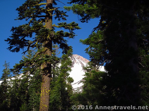
Peek-a-boo views of Mt. Shasta through the trees
At 1.75 miles, come out of the trees and cross Brewer Creek. Or, as it was in August, cross the rocky gully that must sometimes have water in it and is known on my GPS as “Intermittent Stream”. Follow the trail across the meadow.
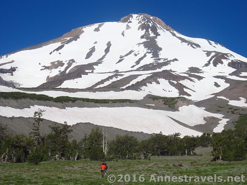
The further you go, the better the views of Mt. Shasta
From here, there are two routes to Butte 9000. I’ll take you up the social trail this week, and next week we can come down via an old jeep road. Both have great views but different flavors, so they make a great loop.
Once on the social trail, the views back down the mountainside get better, as well
For now, follow the trail as it turns to the right to begin ascending the slopes of the mountain. For the next mile, you’ll be climbing a steep trail through thinning trees and ever-more-glorious views of Mt. Shasta and the surrounding mountains and hills. The trail becomes more vague as it climbs, but still should be followable, at least for the first 0.75 miles when it enters confirmed scree slopes – still, the going isn’t too difficult.
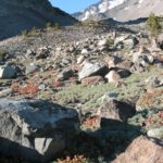
The social trail peters out after a while, but it’s still not hard to tell which way to go… up!
All this time, you’ve been walking along with a valley and large, dark ridge to your left. By this point you should be able to pick out the butte on the ridgeline, to your left. This is your destination. About 1.1 miles beyond Brewer Creek, turn left, off the trail, to come to the crest of the valley that separates you from the ridge.
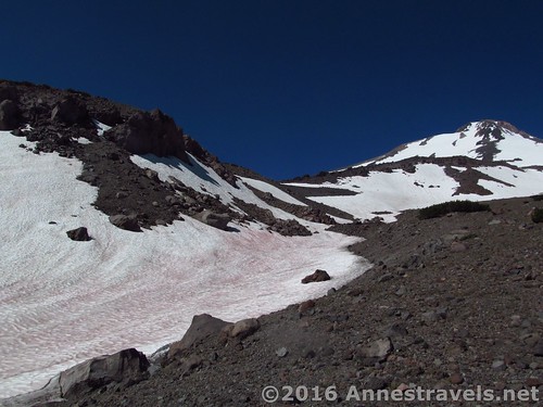
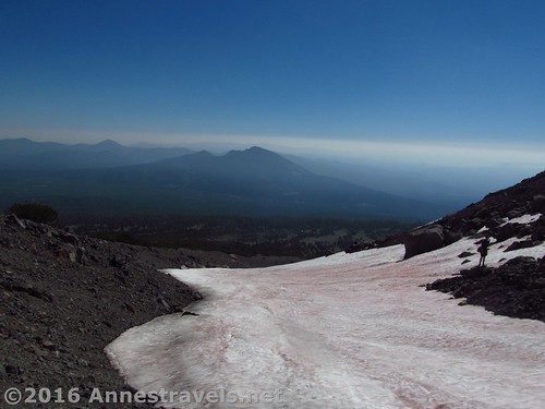
This is the view about the time you’ll want to be heading over to the edge of the gully on the left (you can just see Butte 9000 on the left of this picture)
There are two general routes to ascend Butte 9000 from here. Most of my group members crossed the gully and went up the snowfield on the other side to come up just below the butte, then circled around to its southeastern side to scramble up to the top of the butte. I helped a few members up, so I can say that this works.
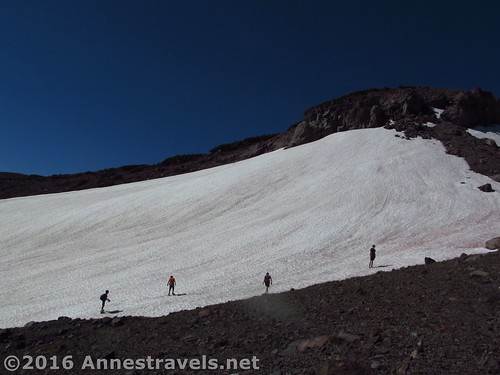
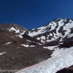
This is the route my hiking companions took – up this snowfield, then left around Butte 9000, then up the other side (dodging bushes and scree)
However, I headed up the side of the gully for a short distance, then descended and crossed it, scrambling up the snowfield on the other side to arrive just west (above) Butte 9000. From here, it was a simple matter of walking down the ridge to the top of the butte. My route was certainly more steep, but I think it was also easier in the long run (just be careful on the snow whichever route you take).
My route was to skirt to the right of the snowfield, then cross it and ascend the snow on the side of the ridge to come up above Butte 9000, then walk down the ridgeline to the Butte proper
Officially, this butte isn’t named and is just a little line on the map. So I’ve taken the liberty of calling it Butte 9000 because, well, I have to call it something, and it’s a lot more impressive to tell your coworkers that you hiked to Butte 9000 over the weekend than that you walked up the side of Mount Shasta to an unnamed ridge, right? (The 9000 bit is based on its elevation – it’s very near the 9,000ft. line on topo maps.)
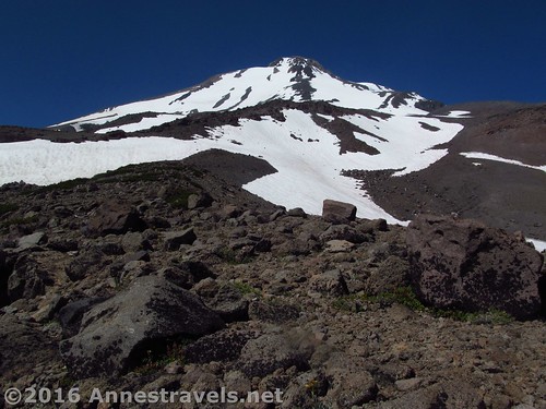
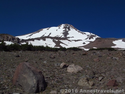
Mt. Shasta from Butte 9000
The view from here is awe-striking: Mt. Shasta’s cone, the valleys around you, the forested hills down below. Mt. Lassen should be visible to the southeast, but it was hazy enough I couldn’t see it.
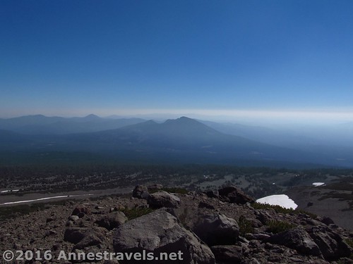
Mt. Lassen is out there somewhere!
We ate lunch, then decided to take a slightly different route back. But I think that’s the topic for another post… because if I thought our outward journey was striking, it pales a bit in comparison to the views from our route down…
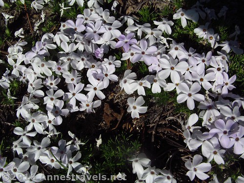
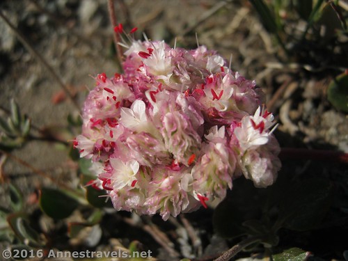
Spreading Plox – the wildflowers weren’t abundant, but there were some around the treeline
Round Trip Trail Distance: About 7.0 miles if you do the loop; it might be slightly (0.8 miles) shorter to return the way you came.
Lowest Elevation: 7,275ft. (trailhead)
Highest Elevation: 8,998ft. (Butte 9000)
Net Elevation Change: 1,723ft.
Facilities: Restrooms at the trailhead
Fees: None (unless you plan on going above 10,000ft., at which point you’ll need to fill out and pay for a $25 per person summit pass)
Trail Notes: There is a lot of off-trail hiking on this route – be prepared! (And there aren’t any reliable water sources, so bring plenty of water – it gets pretty warm even this high in the summer!)
A wildflower finds a place to grow atop Butte 9000
Trail 
Road
Signs
Scenery
Would I go 100 miles out of my way for this?
Overall Rating:
The view down the mountain from Butte 9000
Key GPS Coordinates for the Brewer Creek Trail & Butte 9000
Parking: 41.43506N / -122.13295W (41° 26′ 6.216″ / -122° 7′ 58.6194″) (7,269ft.)
Trail Beginning: 41.43507N / -122.13314W (41° 26′ 6.252″ / -122° 7′ 59.3034″) (7,275ft.) (0.0; ended 7.75)
Enter Mt. Shasta Wilderness: 41.43321N / -122.13321W (41° 25′ 59.556″ / -122° 7′ 59.556″) (7,348ft.) (0.1)
Brewer Creek: 41.42110N / -122.14034W (41° 25′ 15.96″ / -122° 8′ 25.2234″) (7,861ft.) (1.75)
Left Trail to head toward Butte 9000: 41.41877N / -122.15556W (41° 25′ 7.572″ / -122° 9′ 20.0154″) (8,714ft.) (2.8)
Top of Butte 9000: 41.41714N / -122.15715W (41° 25′ 1.704″ / -122° 9′ 25.74″) (8,998ft.) (3.1)
Down the gully with the snowfield
The gpx file for the Brewer Creek Trail / Butte 9000 Loop can be downloaded – please note that this and the GPS Coordinates are for reference only and should not be used as a sole resource when hiking this trail.
Download GPX File size: 214.0 KB Downloaded 97 times
(Note: I do my best to ensure that all downloads, the webpage, etc. are virus-free and accurate; however, I cannot be held responsible for any damage that might result, including but not limited to loss of data, damages to hardware, harm to users, from use of files, information, etc. from this website. Thanks!)
Social trail heading up toward Mt. Shasta
Getting to the Brewer Creek Trailhead
From the North (US-97): From the town of Macdoel, take US-97S 23 miles. Turn left onto Forest Route 19 / Deer Mountain Road / Forest Route 42N12 and drive 15.7 miles. There are signs for Brewer Creek; keep following the signs for this or the signs to stay on Forest Route 19. Turn left for 0.4 miles, then continue straight for 1.5 miles. After this, you simply want to stay on the best-maintained, most main road. Here’s the more complicated directions: Turn left for 0.1 miles, then turn left for 2.9 miles; turn right for 1.1 miles, turn right for 1.9 miles, and you’ll be in the somewhat small parking area for the Brewer Creek Trailhead, with an outhouse and a sign kiosk.
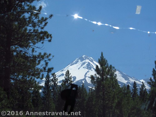
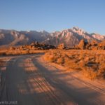
Views of Mt. Shasta (and Shastina, behind the pine tree) from Forest Road 19 en route from US-97. Don’t you love the windshield ornaments?
From the North (I-5): Take Exit 766 toward Grenade / Gazelle. After 0.3 miles, turn left onto 99-97 Cutoff. Continue 18.6 miles, then turn left onto US-97 for 4.4 miles. Turn right onto Forest Route 19 / Deer Mountain Road / Forest Route 42N12, and follow the directions above to the trailhead. (Note: if you’d rather, you can take Exit 748 toward Weed / Klamath Falls for 0.3 miles, then turn left onto Chaparral Drive for 0.1 miles; turn right onto US-99 / N Weed Blvd for 0.5 miles. Turn left at the first cross street onto US-97N for 16.4 miles; turn right onto Forest Route 19 / Deer Mountain Road / Forest Route 42N12, and follow the directions above to the trailhead.)
Pussy Paws along the social trail
From the South (I-5): Take Exit 736 to merge onto CA-89S toward McCloud. After 13.2 miles, turn left onto Pilgrim Creek Road and drive 5.3 miles. Continue onto Forest Route 13 for 2.0 miles, then turn left onto Forest Route 19 for 9.5 miles. Turn left, following the signs for Brewer Creek. From here you’ll want to more or less follow the most used, most main-looking road, but the specific directions are this: After 1.9 miles, continue straight for 0.2 miles, then straight for 0.8 miles; turn left for 1.1 miles, then turn right for 1.9 miles to the trailhead.
Looking back the way we came from Butte 9000
From the South (Lassen National Park): Take CA-44E / CA-89N 78 miles. Turn right onto Pilgrim Creek Road, and follow the directions (above – From the South (I-5)) to the Brewer Creek Trailhead.
The dirt roads should be passable to most vehicles in the summer; however, in the spring, 4×4 may be required. The trailhead is popular with skiers, who tackle the trail even before the road fully thaws.
I highly recommend a GPS to get you through the route to the trailhead – there is a honeycomb of dirt roads out here.
Zoom map out to browse nearby hikes & places of interest
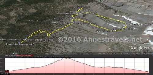
Visual trail map of the Brewer Creek Trailhead (left) to Butte 9000 (right) and then a loop down via an old jeep road (plus a little jaunt to try and find a waterfall – more on that next week!)
This Week’s Featured Product!
Looking for even more hikes in the Mt. Shasta area? Check out this book, with both known and lesser-visited trail options.


Pingback: Sneak Peak: A Land of Volcanos and Oceans - Anne's Travels
Pingback: Out of the Creativity of God's Heart - Anne's Travels
Pingback: Isaiah 40 - Anne's Travels
Pingback: Finishing the Butte 9000 Loop High on Mt. Shasta - Anne's Travels
Pingback: Ooooh… Aaaah…Woooww! - Anne's Travels