

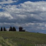
The view from Cement Ridge in October
I’ve heard that Cement Ridge in western Wyoming is the best place in the Black Hills to see the aspen if they’re turning color. After visiting the ridge in early October, I’d have to say that if it’s not the best place, it’s got to be the second best. The views are absolutely stunning when the aspens are turning, and the rest of the year the views would also be very nice. I’ve heard that in mid-summer the wildflowers are fantastic, and are well worth seeing. It’s the kind of view that you look at and say, “Wow.” Then you turn around and look in the next direction and say, “Wow.” And again, “Wow.”

Geological Survey Marker we found on top of the ridge
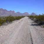
To get to Cement Ridge from Sundance, take I-90 east to exit 191. From here on out, the roads are dirt, although most of them are passable by a low-clearance vehicle, at least in dry weather. Go south on Moskee Road (known by some as Road 141—I never saw a number on it) for about 10 miles and then turn left on Road 875, Grand Canyon Road (again, I don’t recall seeing a number on this road). Follow this road until the road forks, with Grand Canyon Road going right, and Road 804 going left (here I did see a number!). Take the left fork, and drive until you see a brown sign on the right pointing towards Cement Ridge, 2 miles. Turn left at this junction onto Road 850. At this point, if you are driving a low clearance vehicle, you may want to hike up the road to the peak and fire tower. The road from this point on is quite steep and rocky.

The road up to Cement Ridge (it’s actually worse than it looks)
To get to the ridge from Spearfish, take Highway 14A towards Savoy. At the lodge/visitor center, turn right on Road 222, and follow this road to Road 105. As I recall, you will come to a T in the road, and you will want to turn left. Continue to follow Road 105 straight (there are several roads named 105 in this section :-z) until you reach Road 804. Turn west (I believe that’s right) on Road 804 and follow it until you see a brown sign on your left indicating that Cement Ridge is 2 miles to the right. Turn right to follow Road 850 to the top, or park your low-clearance vehicle at the bottom of the road, and hike to the top. All of the roads are closed in winter, and are part of the Black Hills Snowmobile Trail System.

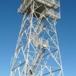
The fire lookout
Near the top of the road is a visitor parking area next to the primitive toilets. From here you can get out and look at the view down across the meadow and into the forests below, or you can walk up to the fire tower itself. Built by the CCCs in the early 1940s, the tower replaced the original wooden structure that was built on the site in the 1920s. Signboards inside the door marked “Wind Shelter” tell about the two fire towers, and other information about the Black Hills National Forest. Don’t let the stiffness of the door deter you; if the top is sticking, push a little harder. It can lock, but that’s in the middle of the door, not at the top.

The view from behind the fire lookout
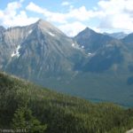
The day we visited, a ranger was in the tower, looking out for forest fires. It would be a great place to look from, because Cement Ridge is higher than just about anything else in that area. You can see for miles and miles in just about every direction. The view encompasses most of the Black Hills, including Crow Peak, Inyan Kara Mountain, Terry Peak, Custer Peak, Spearfish Peak, Rattlesnake Canyon, Wyoming’s Grand Canyon, Wagonwheel Canyon, and Old Baldy Mountain, which we had hiked to the top of several years earlier while visiting the Black Hills of South Dakota. Speaking of South Dakota, Cement Ridge is located just less than 5 miles from the Wyoming/South Dakota border, so most of what you can see to the east is a different state than the one you are standing in.

Overlooking the road up to the lookout
Cement Ridge is on Wyoming’s list of 100 Most Remote Peaks, so it’s worth considering getting a good map if you plan to visit the region (I found that Microsoft Streets & Maps did a good job with the roads in South Dakota, but in Wyoming it was extremely hard to follow, with different road numbers/names etc., especially when coming from Sundance). Be sure to stock up on gas and other supplies before setting out.
Fees: None
Trail 
Road
Signs
Scenery
This Week’s Featured Product!
Find more than 50 hikes in this book to the Black Hills! With hikes in both South Dakota and Wyoming, this is a great resource.

I like it! Your post is really good providing good information. I liked it and enjoyed reading it. Keep sharing such important posts. I am very much pleased with the contents you have mentioned. I wanted to thank you for this great article. I enjoyed every little bit part of it and I will be waiting for the new updates. I really appreciated this post. Just want to say thank you for the information you have shared. Just continue writing this kind of post. Thanks.
Thank you a bunch for sharing this with all of us you actually understand what you are talking about! Bookmarked!
Pingback: Changing Seasons - Anne's Travels
Pingback: Rare History at Aladdin Tipple - Anne's Travels