
Climbing Mount Chiquita, the views are outstanding!
Ever since I read about the Mount Chapin, Mount Chiquita, Ypsilon Mountain loop trail in Rocky Mountain National Park in 2006, I’ve wanted to hike it. I had it all planned, too: We’d go in September, before the snow fell, and we’d have a lovely (if longish for us then) hike (total length is about 8 miles (12.8 km) RT). However, an early snowfall kept us far away from RMNP altogether, and after a few snowy hikes near Colorado Springs (including Raspberry Mountain and the Manitou Railroad Grade) we left Colorado behind for the warmer temperatures of Canyonlands National Park. Still, I never really forgot about the hike.
Quick Stats
Looking back down the trail up Chapin
So imagine my surprise last year when I realized we’d hiked part of the loop – up to Mount Chapin – in 2011. (That’s a story in itself, so I won’t go into it here.) I was looking into visiting RMNP again and thought I’d finally realize the dream of doing the three-summit loop hike. We did it, too, and it was just as gorgeous and I thought it would be. Hoorah!
***Important Note***
The trail begins from the Fall River Road, which was closed for the 2014 season following the extensive flood damage sustained during the fall of 2013. It is being repaired, but will likely not be open until at least 2015. Because of this, the trail probably will not be open to hikers this summer, unless the park allows hikers to walk down from the Alpine Visitor Center to the trailhead – adding 2 miles(3.2 km) each direction to the hike. Recent research leads me to believe that Fall River Road is open to hikers, but not to bikers or motorized vehicles; check with the visitor center before attempting to walk the road.
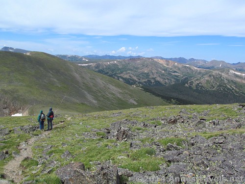
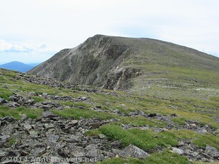
Climbing up Mount Chapin, Mount Chiquita (right) and Ypsilon Mountain are quite visible for planning routes
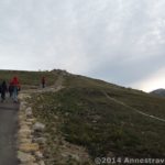
We started the hike very early in the morning because we knew enough about Colorado to know we’d better get up onto the peaks and then down again before the thunderstorms come in every afternoon. (As it turned out, we were on or near Ypsilon Peak when the storms came, so I guess we should have started a little earlier.) The parking area was already crowded, but from the number of people we didn’t see on the trail, I’m going to guess that many of them were overnight backpackers. The trail is easy to follow from the first, climbing uphill through the forest along a trail so worn it is laced with the roots of trees. Watch your footing here; these are serious trip-hazards!
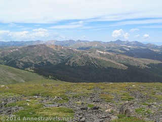
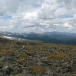
The view from Mount Chapin
After only 0.1 miles (0.2 km), a trail will T off on the right, with the main trail continuing straight. We wanted to go right, following the sign for “Chapin, Chiquita & Ypsilon Summits”. This trail appears to be much more lightly used, but is still heavily enough used to still be a very obvious trail. We continued hiking as the trail passed through forest and meadows, then climbed steeply up rocks to more forest. At 0.5 miles (0.8 km), the trail comes to Chapin Pass; we didn’t know, though, because no sign marks this feature. Instead, we continued on the constantly climbing trail another 0.1 miles (0.2 km) to the tree line and a trail split and a sign: “All Summits, right. Trail Not Maintained Beyond This Point.”
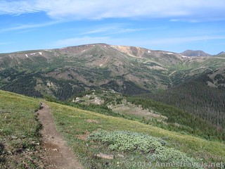
The view while climbing Mount Chiquita
Well, after that encouraging news, we turned right, expecting the trail to peter out or to find ourselves in the middle of a boulder-strewn rock slide or something. Instead, the well-maintained trail continues to climb through the grassy tundra and then across several rock slides (with very nice trails worked into the slides – watch your footing, though). If anything, I think the trail improves after this sign! (Actually, you could take the left fork if you wanted to bypass Mount Chapin. The left fork stays lower longer, then climbs to the saddle between Mount Chapin and Mount Chiquita. I highly recommend it on the way down, as you’ll likely want to lose as much elevation as quickly as possible if afternoon storms are closing in.)
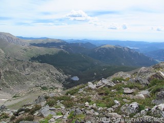
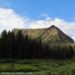
The Mummy Range from Chiquita
By now, you’re really gaining the elevation, and by the time you reach the Chapin / Chiquita saddle, 1.75 miles (2.8 km) from the trailhead, you’re over 12,000ft. (3,500 m). Just before reaching the saddle, however, you have a choice to make: you can bypass Chapin, which is the lowest of the three summits, continue to the saddle, and then turn left up Mount Chiquita, or you can turn right up one of the many social trails just before the saddle and ascend Mount Chapin, 12,454ft. (3,795 m) above sea level. We opted for the later, even though we’d already climbed it once. I guess I figured we hadn’t gotten our hikes’ worth if we didn’t do all three peaks, and secondly, I think everyone in the group wanted to see the view in the semi-sunshine instead of in the rain like we’d seen it the first time. Looking back, I can say that Chapin also has the worst view of the three; you’ll get nearly the same view from Chiquita, only better, so if you want to cut a mile (2 km) off the hike, you can always leave Chapin for another day.
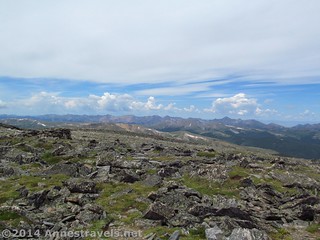
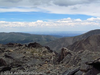
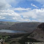
The Rawah Range from the top of Mount Chiquita
I won’t go into detail about Chapin, since I’ve already posted about that here, except to say that you’ll have to follow the social trail up to the peak and the view is excellent. We didn’t spend much time on Chapin except to snap some pictures. The clouds were already not really in our favor and we still had two mountain peaks to go!
From the Chapin / Chiquita saddle, the trail heads left up Mount Chiquita. However, the trail has been getting vaguer ever since Mount Chapin, and fairly quickly it disappears altogether. (Maybe that’s what the sign about the trails’ not being maintained meant!) From here, we followed social trails, erratic cairns, and generally scree-hopped toward the highest point on the mountain. It’s not a super difficult hike, but knowing how to hike without a trail is a must; if you don’t know this, don’t try the hike at all.
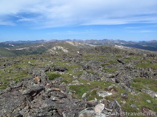
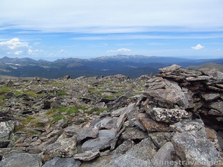
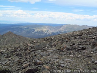
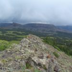
The peaks on the continental divide from Chiquita
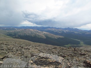
It’s about 1 mile (1.6 km) from the saddle to the top of Mount Chiquita (13,069ft.; 3,983 m). All the while, the view improves, especially of the Never Summer Range and the peaks along the Continental Divide over toward Longs Peak. From the top is one of the most stunning views I’ve seen in the park (the other being from Hallett Peak). I can’t even describe it; I’ll have to let the pictures not do it justice. There is a windbreak at the top if you want to locate the actual peak.
We ate lunch (a mid-morning snack if you’re on Mountain Time) at the top of Mount Chapin, then discussed what we were going to do next. It was late enough in the morning that some of the members of my party were pretty sure they couldn’t make it to the top of Ypsilon before it began to thunder. (Mind you, it was still sunny at this point, but we all know summer Colorado weather, right?) So they graciously suggested that those of us who could hike faster go to the top of Ypsilon and they’d watch us from the Chiquita / Ypsilon Saddle, then start back toward the trailhead if they lost sight of us or a storm started brewing. Usually I don’t like dividing and conquering, but this seemed the best thing to do at that moment – and for once it actually worked out pretty well!
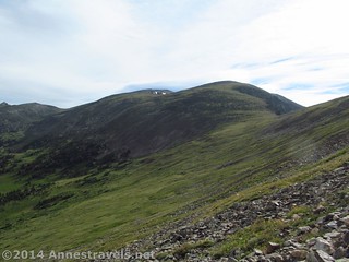
Looking back at Mount Chiquita from the saddle / lower slopes of Ypsilon Mountain
We made our way quickly down from Chiquita and toward Ypsilon Peak. Still, there was no trail, but again it was fairly easy walking (as off-trail hiking goes) so it was just sort of choose-your-own-trail. The Chiquita / Ypsilon saddle is long, but before terribly long we were scrambling up the side of Ypsilon Peak.
The hiking up Ypsilon was a bit more difficult than Chiquita, with even less of a trail and even more erratically placed cairns. We finally decided we’d just pick our own way; it would be faster and easier than trying to follow one social trail after another while constantly stopping to look for the next cairn. The one thing we had to watch out for when shooting for the top was to avoid the false summit on the right. We did end up passing below this to reach the summit and another windbreak right about the time the clouds rolled in for the afternoon thundershower. Pity the clouds; the view would have been tremendous, but as it was the view was still pretty jaw-dropping. You’re so high up here (13,515ft.; 4,119 m) that everything is tiny and far away. I suppose this is why I preferred the Chiquita view to the Ypsilon view, but it was still so worth the hike!

Ascending Ypsilon
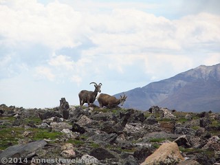
We descended the peak with a roaring wind and occasional sprinkles of rain, but no real thunder to speak of (yay!) Along the way we caught sight of some pronghorns feeding on the mountain slopes. Talk about fun!
At the Chiquita / Ypsilon saddle, instead of re-crossing Chiquita in a brewing thundershower, we opted to hike along the side of the mountain, hoping to maintain enough elevation to descend the trail from the Chapin / Chiquita saddle back toward Chapin Pass (the left fork we didn’t take in the morning). This wasn’t as easy as it sounds. The other parts of the mountains see many hikers every years; this sees very few and thus there is no trail at all. You will be alternately rock-hopping and crossing slippery grass slopes. You’re also walking at a pretty serious angle, which just makes the hike all the more “fun”. Still, it’s a pretty good option if you don’t mind serious off-trail hiking and want to stay off the summits.
View from Ypsilon
We met up with the rest of the group not long before hitting the Mount Chapin Trail. It turned out that they’d had a wonderful time tracking our progress along Ypsilon Peak, so they weren’t bored, at least. We helped them the last mile or so to the trail, then headed down (on a real trail again – I know some of us were pretty happy about that!) toward the “maintained” part of the trail.
We arrived back at the Chapin Creek Trailhead 8 miles (12.8 km) after we’d begun. We were all tired, but I was so happy…my dream of walking the summits had finally come true, 7 years after I’d first envisioned it.
Another view from Ypsilon
Round Trip Trail Length: About 8 miles (12.8 km), including Chapin, Chiquita, and Ypsilon Peaks
Starting Elevation: 10,973 ft. (3,344 m)
Highest Elevation: 13,515 ft. (4,119 m) atop Ypsilon Peak
Net Elevation Gain: 2,542ft. (774 m)
Facilities: None. There aren’t even private bushes above the treeline.
Fees: $20 per vehicle, valid 7 consecutive days, to enter Rocky Mountain National Park. America the Beautiful (Interagency), Senior (Golden Age), Access (Golden Access), Volunteer, Military, and Rocky Mountain Annual Passes also accepted.
Trail 
Road
Signs
Scenery
Would I go 100 miles out of my way for this?
Overall Rating:
Key GPS Coordinates for the Chapin / Chiquita / Ypsilon Loop
Yet another view from Ypsilon
Trailhead: 40.43474N / -105.73055W (40° 26′ 5.0634″ / -105° 43′ 49.9794″) (10,973ft.; 3,344 m)
Chapin / Chiquita / Ypsilon Trail Junction: 40.43665N / -105.72942W (40° 26′ 11.94″ / -105° 43′ 45.912″) (11,158ft.; 3,400 m)
All Summits Junction 2: 40.43541N / -105.72079W (40° 26′ 7.4754″ / -105° 43′ 14.8434″) (11,442ft.; 3,487 m)
Trail up to Mount Chapin: 40.43767N / -105.70330W (40° 26′ 15.6114″ / -105° 42′ 11.8794″) (12,074ft.; 3,680 m)
Chapin Peak: 40.43354N / -105.70187W (40° 26′ 0.744″ / -105° 42′ 6.7314″) (12,435ft.; 3,790 m)
Chiquita Peak: 40.44426N / -105.68927W (40° 26′ 39.3354″ / -105° 41′ 21.3714″) (13,042ft.; 3,975m)
Ypsilon Peak: 40.45737N / -105.68121W (40° 27′ 26.5314″ / -105° 40′ 52.3554″) (13,495ft.; 4,113 m)
Met up with trail back to the parking area: 40.43816N / -105.70528W (40° 26′ 17.376″ / -105° 42′ 19.008″) (11,884ft.; 3,622 m)
The gpx file for the Mount Chapin, Mount Chiquita, and Ypsilon Peak Loop can be downloaded – please note that this and the GPS Coordinates are for reference only and should not be used as a sole resource when hiking this trail.
Download GPX File size: 238.9 KB Downloaded 99 times
(Note: I do my best to ensure that all downloads, the webpage, etc. are virus-free and accurate; however, I cannot be held responsible for any damage that might result, including but not limited to loss of data, damages to hardware, harm to users, from use of files, information, etc. from this website. Thanks!)
Getting to the Chapin / Chiquita / Ypsilon Peaks Trailhead
Pronghorns on the slopes of Ypsilon Mountain
From the Beaver Meadows Entrance Station (main entrance on the East (Estes Park) Side of Rocky Mountain National Park), continue straight on US-36 and US-34 (Trail Ridge Road) for 3.1 miles. Turn right on US-34 E/Fall River Road (this is a well-marked turn). Drive 1.8 miles, then turn left onto the Fall River Road. After 8.5 miles, park on the edge of the road across from the Chapin Creek Trailhead. This is fairly easy to see, especially since there are usually quite a few cars parked near the trailhead. Be sure to park well off the road, but not so far off the road that you go over the edge – the road is right on the brink of a pretty steep drop-off!
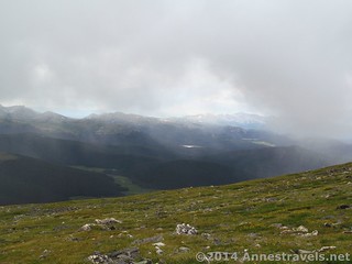
A storm moves in over the Chapin Creek Valley
From the Grand Lake Entrance Station (West Side entrance to Rocky Mountain National Park), drive 37.2 miles on US-34 (Trail Ridge Road). Turn left onto US-34 E/Fall River Road (well-marked in the other direction; likely also well-marked coming from this direction). Drive 1.8 miles, then turn left onto the Fall River Road. After 8.5 miles, park on the edge of the road across from the Chapin Creek Trailhead. This is fairly easy to see, especially since there are usually quite a few cars parked near the trailhead. Be sure to park well off the road, but not so far off the road that you go over the edge – the road is right on the brink of a pretty steep drop-off!
The Fall River Road is graded gravel, suitable for both high-clearance and low-clearance vehicles (it’s quite the thing to take your old-fashioned cars up it…or so it appears from the number of open-topped old cars I’ve seen on the road!)
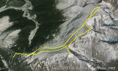
Visual map of the Chapin / Chiquita / Ypsilon Loop
Zoom map out to browse nearby hikes & places of interest
This Week’s Featured Product!
There are so many hikes in this guide, from Rocky Mountain National Park to places you might not have heard of. All are incredibly scenic!
Pingback: The Best of Anne's Travels in 2015 - Anne's Travels
Pingback: Remote Rocky Mountain: Chapin Peak - Anne's Travels
Pingback: 11 of the Best Dayhikes for Mountain Views of Colorado - Anne's Travels