
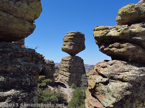
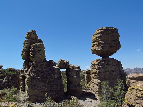
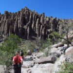
The Big Balanced Rock, framed by two other rock spires
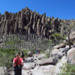
There is no place in the US that is quite like Chiricahua National Monument. Rocky spires shoot straight up out of the hillsides in fantastic formations and an awesome display of uniqueness. Because of this, I’d like to spend a few weeks detailing the trails we hiked there last spring. We did the best hike as a loop, but since this loop ended up being 9.5 miles (15.3 km) long, and there was so much to see along the way, I thought I’d break it up across several posts. In this post, I’ll talk about the first leg of our hike (mostly downhill!) from the Echo Canyon parking area to the Big Balanced Rock, the first of the really cool rock formations along the route. This section of the trail is mostly forested, but there are some nice views of the formations along the way. The views of the surrounding area are also quite good at the moment because of the recent fire (yes, you’ll be walking through charred tree trunks at some points; the views make up for this, however). And, at the end of this leg (4.1 miles (6.6 km) from the parking area), there is the reward of the Big Balancing Rock – and who doesn’t like to see a water-cooler-shaped natural rock formation?
Quick Stats
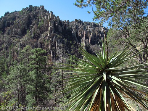
Yucca and spires on the Ed Riggs Trail
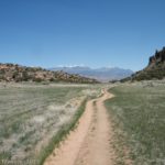
The trail begins by the signboard at the far end of the parking area and quickly drops below the parking area elevation to a trail junction. Turn left toward the Ed Riggs Trail, which begins 0.2 miles (0.3 km) away. The walk through this section can be hot in the warmer months, as bushes block any breeze that might be blowing. There are also very few views. After 0.2 miles (0.3 km), continue straight (right) to follow the Ed Riggs Trail. If you parked at Massai Point, this is where you’ll come into the trail. One of the nice things about Chiricahua is that there are plenty of signs with mileages, etc., on them, so it’s not difficult to know where to go at most trail junctions.
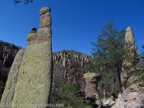
Tall spires on the Ed Riggs Trail
Continue walking as the trail descends toward the bottom of a side valley. I certainly wouldn’t want to have to hike back up this; it’s extremely steep in places to say the least! The fire spared this section of the trail, so you’re very much in the forest as you walk 0.7 miles (1.1 km) to the next trail junction (and the end of the Ed Riggs Trail). As you near the bottom of the valley, there are peek-a-boo views of rock formations around you; this is a wonderful taste of what is to come later on.
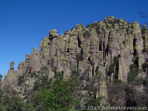
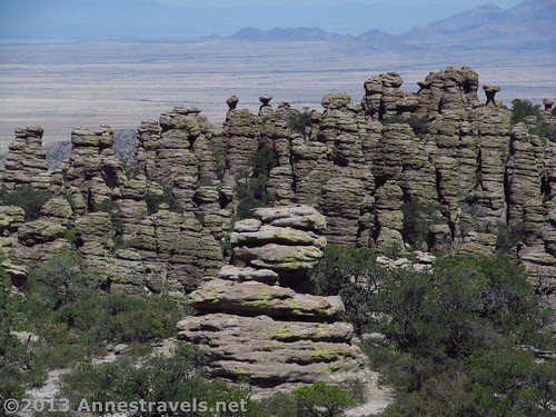
Spires along the Mushroom Rock Trail
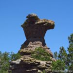
After reaching the valley bottom, turn left onto the Mushroom Rock Trail (instead of turning right onto the Echo Canyon Loop Trail). The trail here begins to climb with more views of wacky rock formations above and around you. However, this section is still fairly forested. A highlight rock formation is the Mushroom Rock, denoted by a sign on the left side of the trail (however, the best place to view the mushroom rock is before you reach the sign – so if you come to the sign, you might want to back up a little for a better photo-angle).
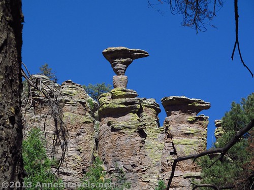
The Mushroom Rock
Before reaching the next trail junction, 1.2 miles (1.9 km) from the Mushroom Rock Trail Junction, you will enter a severely burned out section. Since you’re mostly walking between low hills at this point, it doesn’t do much for your view, but it is a little weird to be walking among the blackened tree trunks with the low foliage beginning to rise again from the gravelly soil. At the end of the Mushroom Rock Trail, there is another trail split. Right goes to Inspiration Point, 0.5 miles (0.8 km) away. The viewpoint is nice, but not nice enough for me to want to waste time and energy on it during this particular hike. So, I turned left onto the Big Balanced Rock Trail.
Mountains from the burned section
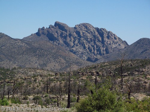
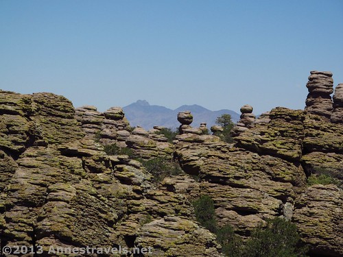
The trail continues through the burned-out forest, finally topping out at a very nice view. Yes, there are the skeletons of burned trees around, but looking beyond there are low mountains, craggy hills, the plains, and the nearby bulk of Sugarloaf Mountain (7,210ft.; 2,197 m). Below Sugarloaf are some rock formations, as well (you’ll be seeing these better later, but these are still interesting). Continuing down the trail, there are peek-a-boo views of rock formations (especially on your right) as you walk through the foliage. One view in particular was especially nice, with the spires looking more like oddly-stacked works of art than rock formations.
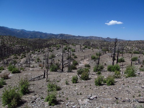
More views in the burned section
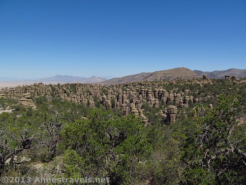
Then, 1 mile (1.6 km) from the Inspiration Point Trail Junction, and 4.1 miles (6.6 km) from the trailhead, the Big Balanced Rock suddenly appears on the left side of the trail. It certainly is odd-looking, but it’s well worth the hike to see it in all its glory. But while you’re looking at it, don’t forget to also take a look around. You’re entering the Heart of Rocks area, so there are more formations all around you than previously on the trail. We paused here for lunch (EDT again!) before going to the actual trail junction just down the trail. I also scrambled my way around to the back side of the Big Balanced Rock; not something I really recommend, but very interesting none-the-less.
Views along the Big Balanced Rock Trail
So…now I’ll keep you in suspense…because (now that we’ve gotten there) I’ll post next week about the very best part of Chiricahua National Monument: The Heart of Rocks!!!
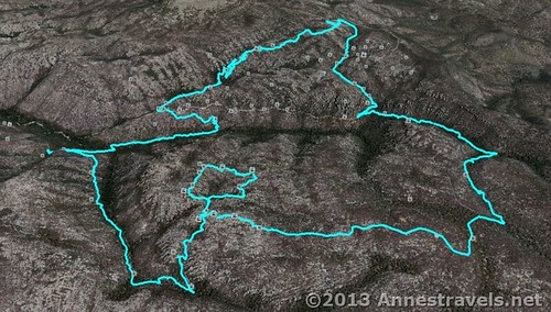
Round Trip Trail Length: To the Big Balanced Rock, the shortest RT trail is 8.2 miles (13.2 km). RT loop (including the Heart of Rocks Trail) is 9.5 miles (15.3 km) (though my GPS came out saying 8.7 miles (14 km))
More spires/views along the Big Balanced Rock Trial
Highest Elevation: 7,480 ft. (2,280 m) (Echo Canyon Parking Area)
Lowest Elevation (on loop): 5,900 ft. (1,798 m) (Sarah Deming Trail / Rhyolite Trail Junction)
Net Elevation Gain/Loss: 1,680 ft. (512 m)
Facilities: Primitive restrooms at the Echo Canyon Trailhead – otherwise, none.
Fees: $5 per person fee (age 16 and older) to enter Chiricahua National Monument, valid 7 days. America the Beautiful (Interagency), Senior (Golden Age), Access (Golden Access), Volunteer, Military, and Chiricahua Annual Passes also accepted – however, note that these only cover the pass holder and three other individuals (we ended up having to pay for one extra person; unlike some parks, these staff members seem serious about enforcing this (but they were very nice, all the same!)). Update: The entrance fees to Chiricahua have been eliminated, so you can now visit for free!
Trail 
Road
Signs
Scenery
Would I go 100 miles out of my way for this?
Overall Rating:
Key GPS Coordinates for the trail to the Big Balanced Rock
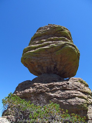
The Big Balanced Rock
Echo Canyon Trailhead: 32.01181N / -109.31577W (32° 0′ 42.5154″ / -109° 18′ 56.772″) (6,778 ft.; 2,066 m)
Ed Riggs Trail Junction: 32.01019N / -109.31374W (32° 0′ 36.684″ / -109° 18′ 49.4634″) (6,666 ft.; 2,031 m)
Mushroom Rock View 1: 32.00026N / -109.30862W (32° 0′ 0.9354″ / -109° 18′ 31.032″) (6,620 ft.; 2,017 m)
Mushroom Rock View 2: 31.99979N / -109.30823W (31° 59′ 59.244″ / -109° 18′ 29.6274″) (6,652 ft.; 2,027 m)
Inspiration Point Trail Junction: 31.99691N / -109.32099W (31° 59′ 48.8754″ / -109° 19′ 15.5634″) (6,906 ft.; 2,105 m)
Big Balanced Rock (1st view): 31.99434N / -109.32160W (31° 59′ 39.624″ / -109° 19′ 17.76″) (6,849 ft.; 2,087 m)
Heart of Rocks Trail Junction: 31.99459N / -109.32260W (31° 59′ 40.5234″ / -109° 19′ 21.3594″) (6,792 ft.; 2,070 m)
The gpx file for the Chiricahua Heart of Rocks Loop can be downloaded – please note that this and the GPS Coordinates are for reference only and should not be used as a sole resource when hiking this trail.
Download GPS File File size: 208.5 KB Downloaded 340 times
(Note: I do my best to ensure that all downloads, the webpage, etc. are virus-free and accurate; however, I cannot be held responsible for any damage that might result, including but not limited to loss of data, damages to hardware, harm to users, from use of files, information, etc. from this website. Thanks!)
Getting to the Echo Canyon Parking Area
The Big Balanced Rock from behind
From I-10 in Arizona, take Exit 340 in Willcox. Head southeast (left if you’re coming from the east, right if you’re coming from the west) on Fort Grant Road/W Rex Allen Drive for 1.1 miles (1.7 km). Turn right onto AZ-186 E (signs will point toward Interstate 10 Business). After 0.7 miles (1.1 km), turn left to continue on AZ-186 E; drive 31.4 miles (50.5 km). Turn left onto AZ-181 for 3 miles (4.8 km), then continue on E Bonita Canyon Road for 7.3 miles (11.7 km). Turn right, following the signs for Sugarloaf and Echo Canyon; take an almost immediate left into the Echo Canyon Parking Area.
If you’re coming from the visitor center, turn right out of the parking area and drive 5.3 miles (8.5 km) to the turnoff for Sugarloaf. Turn right here, then take an almost immediately left into the Echo Canyon Parking Area.
Rock formations behind the Big Balanced Rock
Although the Echo Canyon Parking Area is quite large, the trail is extremely popular. So, if you find the parking area full, you can go back to the main road, turn right, and continue to the end of the road at Massai Point, then take the trail for 0.3 miles to connect with the Ed Riggs Trail.
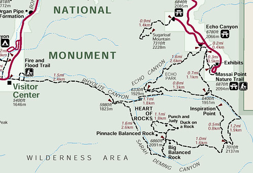
A trail map of the Heart of Rocks area
A visual map of the Heart of Rocks Loop Trail – Echo Canyon Trail to the Ed Rigs Trail to the Mushroom Rock Trail to the Big Balanced Rock Trail to the Heart of Rocks Trail to the Sarah Deming Trail to the Upper Rhyolite Trail to the Echo Canyon Trail – 9.5 miles total.
This Week’s Featured Product!
This newly-revised guide offers hikers a generous number of trails across the state of Arizona, including the trails in Chiricahua National Monument.


Pretty kewl, thanks.
Pingback: Views of Chiricahua Spires: Sarah Deming and Upper Rhyolite Trails
Pingback: Anne's Travels » Finishing the Chiricahua Loop: The Echo Canyon Trail
Pingback: Anne's Travels » Chiricahua Formations: The Heart of Rocks
Nice post. It is an amazing place. Makes me want to go back and spend a few more days exploring it.
Pingback: Anne's Travels » Fantastic Rock Formations at Chiricahua
Pingback: The 12 Most Popular Pictures on Anne's Travels
Pingback: Wonder, Childlikeness, and the Wilderness - Anne's Travels