

Clouds float by the peak of Mt Hood and Cooper Reach along the Cooper Spur Trail
Have you ever seen Mt. Hood? It is a well-known landmark, especially in its home state of Oregon. Many people come every year to climb it, and thousands of others to admire its shapely appearance. One of the best ways to experience the mountain up close is to hike the 7 mile (RT) Cooper Spur Trail. Beyond the fact that you get absolutely awesome views of Mt. Hood, it is the highest constructed trail on the mountain. In fact, the trail takes hikers up to the point where there is no more trail, and those who wish to climb the mountain must cross a snow field and then do some rock climbing to get to the top. In case I haven’t already given it away, the way to get to the top of Mt. Hood is a technical climb, and there are no real trails to the summit, only routes that can be used by those who brave the climb. So, for those of us who aren’t rock climbers, this is the closest we can get to the top.
To get to the trailhead, take Highway 35 south of Hood River (or North from US-26 and Government Camp) and turn onto a road with a sign pointing towards the Cooper Spur Ski Resort. From here you will drive the road for 9 miles up to the Cloud Cap Trailhead (just below the historic Cloud Cap Lodge, which is now closed to the public except when tours of the facility are given). The road is paved for the first 3 miles, and after that it’s a dirt road, although it would not be impassible for low clearance vehicles (as long as they took it carefully). Along the way, you will cross a total of 21 “waterbars”; gravel that has been put in drainages along the road. These require caution, as they could do a real number on a vehicle that was going too fast. After 18 of the waterbars, you will see a turn-off for Tilly Jane Canyon. This is another way to hike up to the Cooper Spur Trail, but my directions will take you from the Cloud Cap trailhead, another mile or so (and several thousand feet higher) up the road.

Sunrise over Mt. Hood
The parking area for the trailhead also serves as a campground, which allows you to get a nice early start on the trail the next morning if you stay overnight. If you do stay overnight, I would suggest getting up around sunrise and climbing to the top of the hill above the campground (towards the historic lodge). From here you get a terrific view of the mountain in the rising sun—totally awesome! The historic lodge itself is 0.2 miles farther up the road beyond the parking for the trailhead.
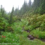
Trail begins next to the sign board beyond the camping area on the right side of the parking lot (as you are driving in). This is the Timberline Trail, which you will follow until you get to its junction with the Cooper Spur Trail. You want to go left up the trail, and sign in at the registration box not far from the signboard. Basically, they want to know who’s using the trail, make sure you’re not violating any number-of-people and/or stock-in-a-group regulations (limited to 12 people per group; check for stock regulations), and know where you are if you don’t come back. Beyond this, the sandy trail climbs steeply through a forest, and then suddenly breaks out of the trees and into glorious views of the mountain. But, wait! Don’t use up all of your film (ok, space on your memory card) yet, as the views really do get batter farther along. That may be hard to believe when you see it, but it’s true. Now you begin to climb up a rocky area near a rock slide. This is still steep, but at least the trail isn’t as sandy, which makes for easier walking.

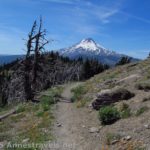
First view of Mt. Hood after you leave the parking lot
Eventually, the trail comes to a junction with the trail up from Tilly Jane Canyon. You could have walked up from this parking area, but it is at a lower elevation, which means you will have to climb up more elevation before reaching this point than you would if you took the Timberline Trail from the Cloud Cap Trailhead. At this point, a sign points up Cooper Spur (going in the opposite direction from the Tilly Jane Trail). After you’ve walked a little way on the Cooper Spur Trail, you will come to the warming hut built by the CCCs. A short spur trail leads to the hut, and it is well-worth looking at, and trying to get a picture of both the hut and the mountain together. Inside, people have left all kinds of food, a lantern, a deck of playing cards, and even bug spray, so it would be a great place to get out of a storm, although I’ve heard that people sleep there on backpacking trips.
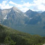
After the side trail to the hut, the trail begins to switchback, and here it is also quite sandy. However, we didn’t figure that out until we came back down, because we actually lost our way in the fog that was lifting out of the valley below us and took a social trail along the edge of the ridge. From there we could see down onto Elliot Glacier, and look at the devastation from a flood down the valley. It looked like pictures I’ve seen from Mt. St. Helens’ eruption in 1980. Speaking of famous mountains, most of the way up this section and from the top you can see Mt. Adams as well as Mt. Rainer. We never saw Mt. St. Helens, but that could just have been due to the fact that the valley was entirely filled with clouds for part of the hike, and even after many of them had risen past us (sometimes obscuring out view of Mt. Hood for a few minutes), there were still plenty of clouds around. You can also see the Colombia River and the town of Hood River.

CCC warming hut
The social trail continues to climb along the edge of the ridge. Most of the way up we decided to get back on the trail (at the end of each switchback the trail connects with the social trail), but that was a mistake: not very far down the trail, it came to a dead end in a snowfield! Don’t worry, people have made many different social trails up to the ridge. By now you can see where you are going (Tie-in Rock), so it’s pretty easy to shoot for as you scramble up the rocks. In terms of which trail you should take, I’d personally recommend taking the social trail along the ridge…unless it challenges you ethically. It’s much prettier than the real trail, although it is also steeper.
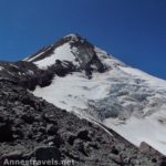
When you get to the top of the ridge (Tie-in Rock) there are a couple of small rock shelters where you can get out of the wind. There is also an inscription on a rock from some early Japanese climbers. From here you can stop (the views of Hood are outstanding), or you can continue up to the snowline. Some of us decided that we hadn’t climbed Cooper Spur if we didn’t go to the end of the trail, so we headed up to the snowline.

Looking down Elliot Glacier from the snowline
The trail continues along the ridge for a short way, then descends down a pile of rocks towards the snow. How far you can go will depend on the time of year. I would not recommend climbing on the snow itself, as it is very slippery, and you never know what sort of stream or hole might be underneath it. This area is a great place to get away from other hikers (at least on weekdays), and you can get great shots of Elliot Glacier, which is now below you.
Return by the way you came. It’s all downhill from here!
One thing to keep in mind is that this is a very exposed trail, and you wouldn’t want to be caught on it during a thunder storm. So, especially in the summer months, you should probably get an early start so as to be off of the mountain by afternoon.
Fees: $5 Northwest Forest Service Pass (per day). Interagency, Golden Age, and Golden Access passes also accepted.
Trail 
Road
Signs
Scenery
Overall Rating:
This Week’s Featured Product!
It doesn’t matter the season with this guidebook to Mt. Hood. There are 85 hikes within its covers that are sure to please.


Pingback: Cooper Spur: Snow, Ice, and Rocks - Anne's Travels
Pingback: Celebrating 20 Years of Family Vacation - Anne's Travels