
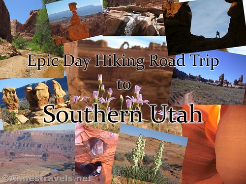
Epic Day Hiking Road Trip to Southern Utah. Clockwise from upper left: Coyote Gulch, rock formation from the Navajo Trail, waterfalls near Broken Bow Arch, Double Arch, the trail through Chesler Park, Spooky Slot, Coyote Gulch wildflowers, Golden Cathedral double pothole in Neon Canyon, Colorado River from Anticline Overlook, and rock formations in Devil’s Garden (GSENM). Center photo: Upper Delicate Arch Overlook.
Southern Utah packs so much beauty into a small area. Arches, rock formations, turrets, towers, spires, mountains, canyons, cliffs, meadows – there’s so much to see, and often so little time to do it.
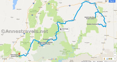
Road map of our day hiking southern Utah road trip: 524 miles (or something like that)
So here are some of the best-of-the-best of Southern Utah, in one epic road trip, with two fast-paced variations – an 8 day trip and an 18 day trip (times do not include travel time to the initial destination or travel time back home). The focus is day hiking (about 7 miles a day, more or less) to some of Utah’s most inspiring natural wonders. Enjoy!
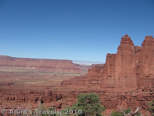
Views from Fisher Towers outside of Moab, Utah
8 Day Itinerary – Epic Day Hiking Road Trip to Southern Utah
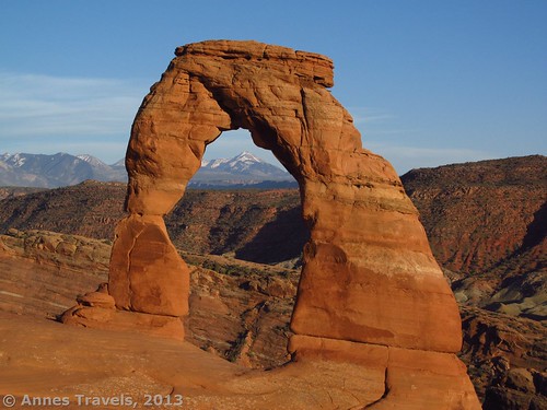
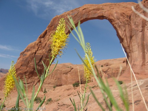
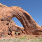
Delicate Arch about an hour before sunset
Day 1 – Arches National Park
Check out the visitor center & walk around the Windows & Double Arch (1.8 miles RT). Climb to Delicate Arch (3 miles RT). Stick around until about an hour before sunset for terrific photo opportunities.
Feeling your Wheaties, even if it is your first day out? Hike to the Upper Delicate Arch Viewpoint (about 1.5 miles RT) or Park Avenue (2 miles RT).
Total miles of hiking: 4.8-8.3
Stay in Moab or Arches National Park vicinity.
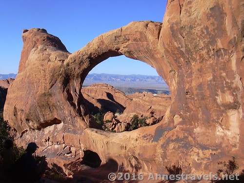
Double O Arch in Devil’s Garden
Day 2 – Arches National Park
Hike the Devil’s Garden Trail (7.2 miles RT; can be shortened) for epic arch encounters.
Total miles of hiking: Up to 7.2
Stay in Moab, Arches National Park vicinity, or Canyonlands National Park, Island in the sky District.
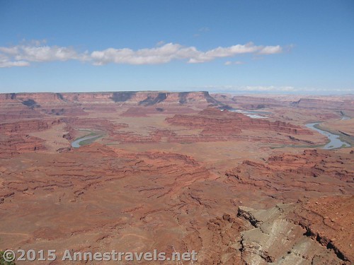
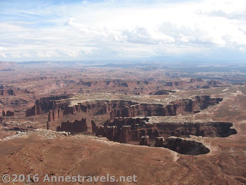
Oxbow Bend in the Colorado River near Canyonlands Overlook, Canyon Rims Special Management Area
Day 3 – Canyonlands National Park, Island in the Sky District / Canyon Rims Special Management Area
Drive 45 minutes to Canyonlands National Park, Island in the Sky District. Stroll to Mesa Arch (0.7 mile loop), then take the steps out to Grand View Point (2 miles RT). Drive 2 hours down to Canyon Rims Special Management Area. Enjoy views of Utah Canyon Country and the Canyonlands from the Needles Overlook, Miner Overlook, and Anticline Overlook.
Total miles of hiking: 2.7 + however much you explore at the overlooks
Drive south to stay in Monticello or Canyonlands National Park, Needles District (an hour south of Canyon Rims).
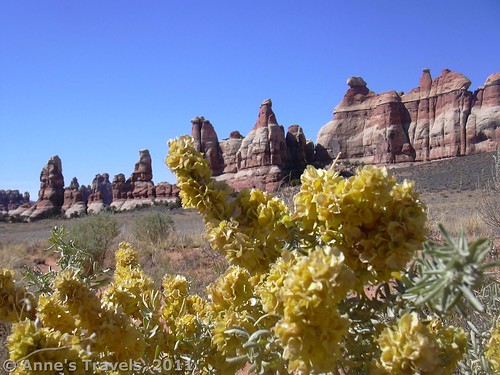
Wildflowers in Chesler Park
Day 4 – Canyonlands National Park, Needles District
Hike to Chesler Park and the Joints (about 9 miles RT – can be shortened to 6 miles RT). The hoodoos in a desert meadow won’t disappoint on scenery, and the slot canyons are a cool little feature! (If you really want a challenge, hike to Druid Arch, looping back through Chesler Park and The Joint, for a 14 mile trek.)
Total miles of hiking: 9.0; more if you explore The Joint in depth.
Stay in Monticello or Canyonlands National Park, Needles District.
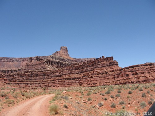
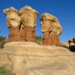
Rock formations in Devil’s Garden
Day 5 – Travel Day
Drive to Escalante, Utah, area (about 6 hours). We’ll be exploring Hole in the Rock Road tomorrow.
Total miles of hiking: 0.0. Unless you decide to stop and take in a few viewpoints in Capitol Reef National Park (you’ll be driving right through).
Stay in Escalante, Calf Creek Falls Recreation Area, Escalante State Park, or free-range camp along the Hole in the Rock Road.
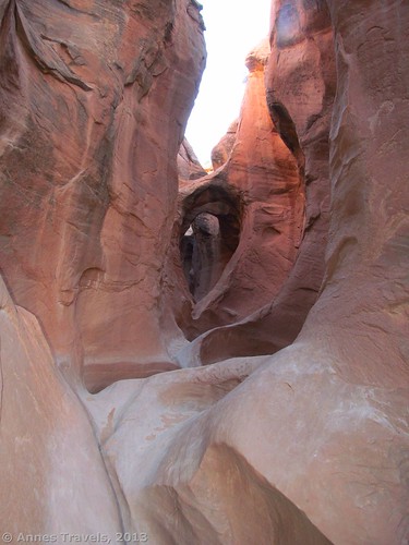
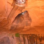
Arches and curves in Peek-a-boo Slot
Day 6 – Hole in the Rock Road
Drive down the road to Devil’s Garden. Spend 30 minutes to an hour exploring the rock garden (via the social trail or without a trail). Continue down the road to Peek-a-boo and Spooky slot canyons (3.5-4 miles RT).
Total miles of hiking: 4+ depending on exploration ambitions.
Stay in Escalante, Calf Creek Falls Recreation Area, Escalante State Park, or free-range camp along the Hole in the Rock Road.
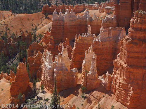
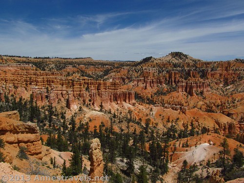
Hoodoos from the Queen’s Garden Trail
Day 7 – Bryce Canyon National Park
Drive to Bryce Canyon (about 1 hour).
Hike down the Queen’s Garden Trail from Sunrise Point to access the Peek-a-boo Trail. Hike the Peek-a-boo Loop, then return to the rim at Sunset Point via the Navajo Trail. Take the free park shuttle back to Sunrise Point, or hike a half mile along the Rim Trail. Total hiking distance is 5.4-5.9 miles RT through fantastic spires and formations.
Total miles of hiking: 5.4-5.9
Stay in or near Bryce Canyon National Park, or along US-89.
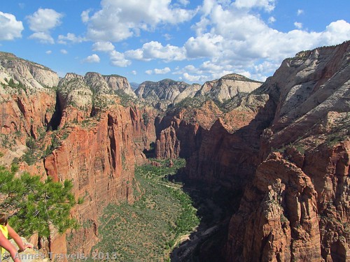
Views up Zion Canyon from Angel’s Landing
Day 8 – Zion National Park
Drive 2-3 hours to Zion National Park. Climb Angel’s Landing (5 miles RT) for terrific views of Zion Canyon. If you don’t like heights, stop at the beginning of the Landing (4 miles RT).
Total miles of hiking: 4.0-5.0
Stay in Zion National Park or Springdale.
18 Day Itinerary – Epic Day Hiking Road Trip to Southern Utah
Delicate Arch about an hour before sunset
Day 1 – Arches National Park
Check out the visitor center & walk around the Windows & Double Arch (1.8 miles RT). Climb to Delicate Arch (3 miles RT). Stick around until about an hour before sunset for terrific photo opportunities.
Feeling your Wheaties, even if it is your first day out? Hike to the Upper Delicate Arch Viewpoint (about 1.5 miles RT) or Park Avenue (2 miles RT).
Total miles of hiking: 4.8-8.3
Stay in Moab or Arches National Park vicinity.
Double O Arch in Devil’s Garden
Day 2 – Arches National Park
Hike the Devil’s Garden Trail (7.2 miles RT; can be shortened) for epic arch encounters.
Total miles of hiking: Up to 7.2
Stay in Moab, Arches National Park vicinity, or Canyonlands National Park, Island in the sky District.
Views from Hidden Valley
Day 3 – Hidden Valley & Corona Arch
Morning – Hike to Hidden Valley (4 miles RT) for views of the La Sal Mountains in a high desert meadow. OR hike to Fisher Towers (4.4 miles RT) for views of unique rock formations, rock climbers, Onion Creek Road, and the Colorado River Valley.
Afternoon – Take the trail to Corona Arch (3 miles RT).
Total miles of hiking: 7.0-7.4
Stay in Moab, Arches National Park vicinity, or free-range camp in the public land beyond Potash along the Potash Road.
The Potash Road
Day 4 – Potash Road & Shafer Trail
Drive from the “town” of potash along the Potash Road, then up the Shafer Trail into Canyonlands National Park, Island in the Sky District. The views of Utah canyon country are beyond epic.
Total miles of hiking: 0.0, unless you decide to stop and explore
Stay in Canyonlands National Park, Island in the Sky District, or in Moab
Note: High clearance (and possibly 4×4) is required to drive the Potash Road and incredibly rough Shafer Trail. Neither road is accessible in wet or snowy conditions. If you don’t have 4×4, drive up to Island in the Sky District via the highway (about 45 minutes) and be a day ahead 🙂
Views from Grand View Point
Day 5 – Canyonlands National Park, Island in the Sky District
Stroll to Mesa Arch (0.7 mile loop), then trek to the top of Whale Rock (1 mile RT) and take the steps out to Grand View Point (2 miles RT) for terrific views over The Maze and Canyonlands.
Finish off the day by hiking to White Rim Overlook (1.8 miles RT) and Upheaval Dome (1.7 miles RT). (If you want to shorten the hikes, skip Upheaval Dome and either Whale Rock or White Rim Overlook, depending on interests.)
Total miles of hiking: 7.2
Stay in Canyonlands National Park, Island in the Sky District, Moab, Arches National Park, Wind Whistle Campground or Hatch Point Campground (Canyon Rims Special Management Area), or free-range camp on the public land around Canyon Rims Special Management Area.
Oxbow Bend in the Colorado River near Canyonlands Overlook, Canyon Rims Special Management Area
Day 6 – Canyon Rims Special Management Area
Drive 2 hours down to Canyon Rims Special Management Area. Enjoy views of Utah Canyon Country and the Canyonlands from the Needles Overlook, Miner Overlook, and Anticline Overlook. If you have 4×4, drive out to Canyonlands Overlook.
Total miles of hiking: Varies. 0.0+ depending on how much you explore
Drive south to stay in Monticello or Canyonlands National Park, Needles District. If you still have time, take part of the Big Spring Canyon Trail in the Needles District as you have time and energy.
Wildflowers in Chesler Park
Day 7 – Canyonlands National Park, Needles District
Hike to Chesler Park and the Joints (about 9 miles RT). The hoodoos in a desert meadow won’t disappoint on scenery, and the slot canyons are a cool little feature!
Total miles of hiking: 9.0, more if you explore the Joints in depth
Stay in Monticello or Canyonlands National Park, Needles District.
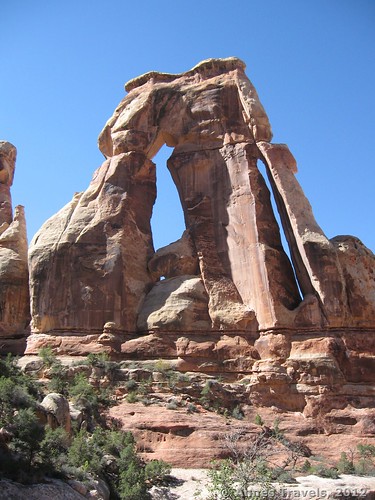
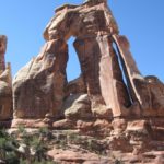
Druid Arch
Day 8 – Canyonlands National Park, Needles District
If you really want a challenge, hike to Druid Arch (10.2 miles) in a spectacularly crazy canyon.
For less of a challenge, hike the Confluence Trail (11 miles RT, but not as sandy) through the desert to a view over the confluence of the Green and Colorado Rivers deep in a red canyon.
Total miles of hiking: 10.2-11 miles
Stay in Monticello or Canyonlands National Park, Needles District.
Rock formations in Devil’s Garden
Day 9 – Travel Day
Drive to Escalante, Utah, area (about 6 hours). We’ll be exploring Hole in the Rock Road tomorrow.
Total miles of hiking: 0.0. Unless you decide to stop and take in a few viewpoints in Capitol Reef National Park (you’ll be driving right through).
Stay in Escalante, Calf Creek Falls Recreation Area, Escalante State Park, or free-range camp along the Hole in the Rock Road.
Arches and curves in Peek-a-boo Slot
Day 10 – Hole in the Rock Road
Drive down the road to Devil’s Garden. Spend 30 minutes to an hour exploring the rock garden (via the social trail or without a trail).
Continue down the road to Peek-a-boo and Spooky slot canyons (3.5-4 miles RT)
Total miles of hiking: 4+ depending on exploration ambitions.
Stay in Escalante, Calf Creek Falls Recreation Area, Escalante State Park, or free-range camp along the Hole in the Rock Road – if you are free-range camping, drive toward the Egypt Trailhead to be in position for tomorrow’s hike.
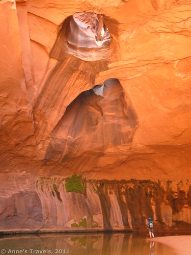
Golden Cathedral in Neon Canyon
Day 11 – Hole in the Rock Road
Take the Beeline Route (about 8 miles RT) or the Fence Canyon Route (about 12 miles RT) to Neon Canyon and the Golden Cathedral with brightly colored walls and pothole arches.
Total miles of hiking: 8.0-12.0, depending on route
Stay in Escalante, Calf Creek Falls Recreation Area, Escalante State Park, or free-range camp along the Hole in the Rock Road – if you are free-range camping, drive toward Willow Gulch to be in position for tomorrow’s hike.
Note: High clearance may be required on the Egypt road. The road is impassable in inclement weather.
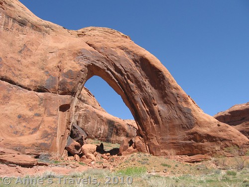
Broken Bow Arch
Day 12 – Hole in the Rock Road
Drive to & hike Broken Bow Arch (6 miles RT). If desired, walk through the stream beyond the arch for a canyon experience and small slickrock waterfalls.
Total miles of hiking: 6.0+ depending on exploration
Stay in Escalante, Calf Creek Falls Recreation Area, Escalante State Park, or free-range camp along the Hole in the Rock Road – if you are free-range camping, drive toward the end of the road to be in position for tomorrow’s hike.
Note: High clearance may be required to reach the Willow Gulch Road. The road is impassable in inclement weather.
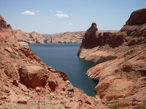
Lake Powell below Hole in the Rock
Day 13 – Hole in the Rock Road
Drive to Hole in the Rock at the end of the road. Scramble down the narrow, rocky Hole in the Rock (about 0.5 miles RT) to Lake Powell, then back up to your vehicle. Drive back up the road to 40 Mile Ridge Road.
Total miles of hiking: 0.5, assuming the road is passable and you don’t decide to explore further
I highly recommend free-range camping along 40 Mile Ridge Road to be in position for tomorrow’s hike. However, you could stay in Escalante, Calf Creek Falls Recreation Area, Escalante State Park, or free-range camp elsewhere along the Hole in the Rock Road.
Note: High clearance is required, and 4×4 may be required, to reach Hole in the Rock (if it’s too crazy, you may be able to walk or bike the last mile or so to the end of the road). The road is impassable in inclement weather.

Coyote Gulch near Jacob Hamblin Arch
Day 14 – Hole in the Rock Road
Hike Coyote Gulch (about 8 miles RT) for canyon views, slickrock, arches, and waterfalls – don’t confuse this with the slots of the Dry Fork of Coyote Gulch, aka Peek-a-boo and Spooky Slots. Afterward, drive back out to or toward Escalante.
Total miles of hiking: About 8 miles. The gulch can be explored as far or short as you desire.
Stay in Escalante, Calf Creek Falls Recreation Area, Escalante State Park, or free-range camp along the Hole in the Rock Road.
Note: High clearance may be required to reach Coyote Gulch. Just after the water tank, a large sand pit makes further progress impossible without 4×4. The road is impassable in inclement weather.
Hoodoos from the Queen’s Garden Trail
Day 15 – Bryce Canyon National Park
Drive to Bryce Canyon (about 1 hour). Hike down the Queen’s Garden Trail from Sunrise Point to access the Peek-a-boo Trail. Hike the Peek-a-boo Loop, then return to the rim at Sunset Point via the Navajo Trail. Take the free park shuttle back to Sunrise Point, or hike a half mile along the Rim Trail. Total hiking distance is 5.4-5.9 miles RT through fantastic spires and formations.
Total miles of hiking: 5.4-5.9
Stay in or near Bryce Canyon National Park, or along US-89.
Some of the views from the Fairyland Trail
Day 16 – Bryce Canyon National Park
Hike the Fairyland Trail (8.25 miles) through the fantastically shaped, colorful spires of Bryce Canyon.
Total miles of hiking: 8.25
Stay in or near Bryce Canyon National Park, or along US-89.
Views up Zion Canyon from Angel’s Landing
Day 17 – Zion National Park
Drive to Zion National Park (about 2-3 hours).
Hike Angel’s Landing (5 miles RT) for terrific aerial views of Zion Canyon (if heights aren’t your thing, hike only to the beginning of the Landing (4 miles RT with some nice views).)
Total miles of hiking: 4.0-5.0
Stay in Zion National Park or Springdale
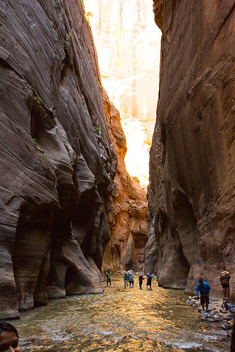
The Narrows in Zion National Park
Day 18 – Zion National Park
If it’s the right time of year (summer before monsoon season, or a warm fall day) and if you have close-toed shoes and clothes you don’t mind getting wet, hike the Zion Narrows. This classic hike up the Virgin River is flexible with however far you want to go (most people do not go more than 8 miles RT).
If it’s not the right time of year / you don’t have the equipment / you simply don’t want to do the Narrows, check out Hidden Canyon (3.3 miles RT), Weeping Rock (0.4 miles RT) and / or part of the West Rim Trail (total of 36 miles RT) for views of Zion Canyon.
Total miles of hiking: Varies – up to 36 miles RT
Stay in Zion National Park or Springdale
Corona Arch near Moab
Notes and Warnings
Days do not include time to get to Moab, or return from Zion.
Time does not include going to a restaurant for meals – I’m assuming you’ll be roughing it.
If you need to stock up on supplies / gas along the way, Moab, Monticello, Escalante, and Springdale are good options.
Do not hike in slot canyons if rain is in the forecast. Be constantly wary of flash floods.
Always take plenty of water when hiking in the desert – and drink it!
Take and eat protein and calorie rich foods while hiking to stay energized.
Don’t try this itinerary in the summer, when temperatures over 100F are to be expected. Fall is the best time (after monsoon season, but the snow has melted off of higher elevation parks like Bryce Canyon), but spring is also lovely, with fresh wild flowers and new growth.
Zoom map out to browse nearby hikes & places of interest
This Week’s Featured Product!
Looking for more road trips? Check out this book, renowned for its road trip itineraries.


Great list! I did something almost identical to your 8-day road trip itinerary through southern Utah last October (but in ten days). I didn’t do Escalante but added Capitol Reef NP – I’ll have to check out Escalante next time!
Sounds like fun, John. I haven’t done it all in one trip (yet!), but I think it would be fun to do the Narrows in Zion again…