

Wildflowers bloom on top of Fitzpatrick Peak, Colorado
At the end of a recent trip to Colorado, we suddenly realized that we’d climbed mountains that were 10,000, 11,000, 12,000, and 14,000 ft high. We decided that we definitely needed to climb a 13er just to complete our record. And, oh, did we find the perfect 13er to climb. Situated above the historic Tincup Pass near Buena Vista Colorado, Fitzpatrick Peak had one of the most awesome views we saw on the entire trip. And the best part of it was that the “trail” was only 3 miles RT!

Looking up at Fitzpatrick Peak from the road leading up to Tincup Pass
There appear to be two ways to get to Fitzpatrick Peak. We followed the directions in a tourism book I had, but to do this you really need high clearance and 4×4. We did it with just high clearance, but it’s not something I’d recommend. The road is quite rough in places, and can be slippery when wet. To get in this way, from the town of Buena Vista take US-24 East to Rt 285. Take US-285 South for about 5.5 miles; then turn right onto Chalk Creek Road (Co Road 162). (If you’re coming from the south, you can take US-285 North to Chalk Creek Road; if you’re coming from the east, take US-24/US-285 West and stay on US-285 when US-24 goes north toward Buena Vista.) The “ghost town” (it was pretty alive on 4th of July weekend!) of St. Elmo is about 16 miles up this road. On the way, you will pass the parking area for Angus Falls, so you can stop and see the falls if you want. In the town, you will need to turn right onto Co Road 267. After crossing the small bridge, the road turns sharply to the left. Not too long after this, the road will split into a Y. You want to take the road that is straight ahead and goes steeply uphill next to the sign that points towards Tincup Pass.

Along the road near the mud hole
There are many good camping spots in this area. We went about a mile further and found a nice one that didn’t have anyone in it. (Just after the big hill is a sign saying that you are now entering the national forest and can free-range camp, which is something you can’t do before St. Elmo.) We were glad we found it, too, because later many people came by looking for sites. Still, there are so many that even on 4th of July weekend there were still a few untaken spots. The next morning we continued up the road toward Tincup Pass. However, at 21.5 miles from the beginning of the road, there was a huge mud hole that went across the entire road. We might have been able to cross it, but we didn’t want to try it. We were glad we hadn’t later when we came back from our hike. Many ATVs and dirt bikes had gone through the hole, and it would have been virtually impossible for us to do it later in the day. It was only another mile or so up the road to the pass, so we hiked it. I believe that in the winter this road is marked by orange spikes so that snowmobilers can use it.

A ptarmigan we saw along the hike
From what we could see, it appears that we could have gotten to Tincup Pass from the west. From US-50, head east on Co Road 76 toward Earl Lane and the town of Parlin for 15 miles. Then, continue on Main Street for 1 mile; turn left at State Street for 0.3 miles and continue onto Co Road 76 for ½ a mile. Although you are just continuing on down the road, it keeps changing names: it becomes Forest Service Road 765 for 0.4 miles, then Forest Service Road for 2.6 miles, Co Road 765 for 0.9 miles, Forest Service Road 765 for 6.2 miles, and Co Road 765 for the next 2.2 miles. You have now come down the road approximately 28 miles. Turn left to stay on Co Road 765 for 6.3 miles, then turn right at Co Road 267/Washington St and travel 0.2 miles. Turn right at Co Road 267 and travel approximately 6.5 miles to Tincup Pass. There may be a better way to do this from the west; if so, comment and tell me about it!

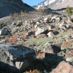
The “trail” up towards Fitzpatrick Peak
The trail begins at the top of Tincup Pass, next to the sign that that says, “Continental Divide”. Actually, there really isn’t a trail, but a vague track starts here, and goes uphill. The other side of the road looked like it would also have had a nice view (there’s a “trail” going up that mountain too), but we took the trail on the side of the road with the continental divide sign, because that’s what a topo map I had with me said was the right way to go. There are no signs marking Fitzpatrick Peak, which may contribute to its non-popularity.
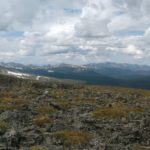
The “trail” ascends steeply, but that’s not a bad thing, as when you have to stop and rest you can look at the view. And what a view. You can see valleys and snow-capped mountains, the road leading to and out of Tincup Pass and pretty little Mirror Lake near the town of Tincup (you can’t see the town of Tincup, though). There were also the prettiest wildflowers all over the hillside. I got some really good shots of some little sunflowers with the mountain scenery in the background.

The view while climbing up to Fitzpatrick Peak
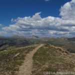
Not too far up the hill the trail all but disappears, but don’t worry. Just keep following the ridge over 2-3 false summits and you will eventually reach the top of Fitzpatrick Peak. The summits are rocky and have many loose stones, so care should be taken on this section of the trail. You know you have reached the top of Fitzpatrick Peak when you are higher than just about any peak around you (expect for one a long way to the left) and the ridge divides, with one ridge going right and the other left. There is a pile of rocks in the middle of the peak, which is a great vantage point from which to view the surrounding countryside.
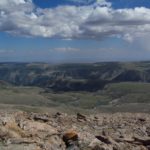
How should I describe the view? Well, it’s amazingly beautiful. Awe-inspiring. Spectacular! You are surrounded by mountains of many different heights, so you can have green hills, rocky ridges, and snow-capped peaks all in one picture. There are also pine forests, stands of aspen (this would be a great hike when the aspen are in color), a lake, tundra, and just about everything in between. But before you leave, don’t forget to look down at your feet, as up here there are some more great wildflowers poking up through the rocks and gravel on top of the mountain.

Walking along the ridge
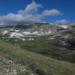
From here, you can return the way you came. However, we decided to go down the right (if your back is to Tincup Pass) ridge for a ways and see what other views we could get. We scrambled down the loose rock, and then found ourselves on a kind of turf/tundra. It wasn’t too hard hiking, and we could move fairly easily along the ridge. The views from here were also gorgeous, with a better look onto the side of the ridge away from the road. The thing that most impressed me was that, unlike so many of the other views we’d had from the top of mountains, there weren’t any ski slopes, towns, real roads, etc. All you could see was wilderness, and that to me made it worth climbing the peak.

The view from the ridge
One of the great things about this place is that it’s not very well visited—we were there on a big holiday, and although the road had jeeps, golf carts, ATV’s, and other off-road vehicles on it, no one else came up the peak. If you turn you back on the road, or come at a time when less people use the road, you get the feeling that you are totally alone in the wilderness. That’s the feeling that I go to the wilderness for!
Trail 
Road
Signs
Scenery
Overall Rating:
This Week’s Featured Product!
If you love great views, you’ll love this guide to Colorado! Check it out free with KindleUnlimited!

Pingback: 12 Places Worth Visiting at least 10 Miles Down a Dirt Road
Pingback: 10 Places to Go Exploring in the Western US - Anne's Travels
Pingback: Celebrating 20 Years of Family Vacation - Anne's Travels
Pingback: 11 of the Best Dayhikes for Mountain Views of Colorado - Anne's Travels