

The Big Balancing Rock
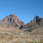
In Big Bend National Park is a valley that seems full of rocks. Unlike the Chisos Basin, this part of the park is defiantly desert, but with rocks and boulders strewn everywhere, up the hillsides, in the valley, and my favorite, across each other to create a unique balancing rock arch. This is the Grapevine Hills section of Big Bend, and it’s defiantly one I like to explore when I visit the park. At the end of a 1.1 mile (one way) trail through these rocks and boulders is the arch, which in itself is a phenomenon worth seeing.
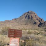
From the Panther Junction Visitor Center, drive west for just over 3 miles to a dirt road on your right. Not long before the turn, the road up to the Chisos Basin will go off on your left. A sign at the dirt road should point the way towards Grapevine Hills. The trail itself is known as the Grapevine Hills Trail, but we usually refer to it by the trail’s destination—Balancing Rock (Arch) Trail—so that’s why I keep referring to “the arch”, but am directing you towards Grapevine Hills. Down this road are several backcountry campsites, some of which are accessible by two-wheel-drive, low-clearance vehicles (backcountry permits are available at the visitor center). To get to the trailhead, I would recommend high clearance, although depending on road conditions—and your respect for your vehicle—this may not be an issue. Check at the visitor center for current road conditions. Continue driving down this dirt road for 7 miles. It starts out quite good, but gradually gets worse, until you finally arrive at the trailhead/parking area on your right (the road gets quite a bit worse after the trailhead). I’ll always remember this road as the first dirt road I drove on after I got my driving permit…I almost handed over the wheel to a more experienced driver at one point, but it got better again, and I made it to the trailhead!

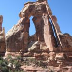
Boulders around the arch
From the parking area, the trail begins near the signs that talk about the trail. The trail itself is not hard to follow, although there are plenty of “bunny trails” that go off of it. I gather that families come out here to let the children scramble around on the boulders, so the number of social trails is quite amazing! In general, stay on the well-traveled path and you’ll be ok. The trail winds its way up the valley, between sage bushes, around boulders, through sand, and generally in a fairly straight line away from the parking area. The trail is very sandy, so although it’s only a little more than a mile, it feels twice that when you’re hiking it. Eventually you will have to climb up some steep, uneven rock stairs, but this means that you are getting close to the arch.

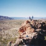
Looking back down the valley from above the arch
After about a mile you will reach the arch itself. It always surprises me how small the arch is, and how large the boulders are that make it. You can hike right up inside it if you want, although some might not enjoy the thought of having a multi-ton boulder hanging over their head! For the best views, go around to the back side of the arch, which also makes the arch look bigger. This is not on the trail, but the views from here are better both of the arch and the surrounding country. The view is best in the morning, because by mid-afternoon the arch is in the shadow of the hill beside it, and there’s no way to get a good picture of it. The arch is also known as the Big Balancing Rock.
However, the country surrounding the arch is worth pictures, no matter the time of day. You can see some of the rock-studded valley from the arch, but the more adventurous may want to climb up the hillside near the arch for a better view across the valley. Especially in the sunshine, the view of the rocks and boulders leveling off into plains is stunning. The national park service calls this area as “one of the most picturesque spots in Big Bend”. I can see why: it’s totally awe-inspiring!

Looking up the valley from the hillside above the arch
Return by the way you came. The good thing about hiking this in the afternoon is that you will be in shadow for most if not all of the hike. However, as I said, the arch will probably also be in shadow, so plan accordingly. Other than the shadow of the hill, the trail is quite exposed, and would be a very hot hike in the summer.
Round Trip Trail Length: 2.2 miles (3.5 km)
Facilities: None
Fees: $20 per vehicle; good 7 days. America the Beautiful (Interagency), Senior (Golden Age), Access (Golden Access), Volunteer, Military, and Big Bend Annual Passes also accepted
Trail 
Road
Signs
Scenery
Overall Rating:
This Week’s Featured Product!
Discover over 50 other hikes in Big Bend in this book!


Pingback: Anne's Travels » Backcountry Car Camping in Big Bend pt 1
Pingback: The Best Hikes in Big Bend National Park