

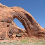
Looking down through a fallen arch
In Southern Utah there is a fin—or a butte—or a mesa—whatever you want to call it—that sticks up almost out of nowhere just north of the Lake Powell Dam. We visited the fin while searching for Skylight Arch, which I had read about on internet sites. We never did hike to the arch (my directions were sketchy at best, and misleading at worst), but instead ended up having an awesome hike up to the mesa top, with gorgeous views of Lake Powell and the surrounding area. We also found out what arches look like after they fall: there are probably at least half a dozen fallen arches in this area. However, if you can look beyond what the arches are now to the beauty around it, it’s well worth a 2+ hour jaunt up to see the view. (Guess what?!? A few years later, I finally found a way to visit Skylight Arch that doesn’t require 4×4!)
To get to this area, take US 89 8 miles north of the Lake Powell Dam and Page, AZ to a dirt road on your left. (You will be in Utah at his point). The dirt road is located directly across from a highway sign that says, “Kanab, 64”. This dirt road is also approximately 7 miles south of Big Water, Utah. Turn onto the dirt road, and follow it as it parallels the fin on your right. At some point on this road, you will cross back into Arizona—I didn’t realize that until I looked at a map later! At the cattle guard, go left, then turn right just beyond the corral. A network of roads snake through this area, but it’s not too difficult to get to the parking area from here. When you get to the fence, turn right (the left fork won’t take you too far; it’s more of a parking area than a real road), then go left at the Y. Going right wouldn’t be bad, as you could get up to the mesa from either parking area, but we decided to go left. Not long after this there will be a small clear sandy area where you can park your vehicle (GPS coordinate: 36°59’39” N 111°36’03” W). The road to the corral is fairly good (enough so that we saw a small camper parked there), but after that the road gets somewhat sandy. You could probably do it with 2-wheel-drive (we did!), but only if you don’t mind pushing your vehicle should it get stuck. Don’t stop, and you probably won’t get stuck. This would probably be an easy road with 4×4.

The fallen arch from underneath
While researching how to get to Skylight Arch, the first thing that I found out is that there are a lot of really misleading directions on the internet, and a lot of sites that say, “Hey, Skylight Arch exists”, and then leave you with no more information than your started with. Probably one of the most helpful sites explained that you can get a great view of the arch at milepost 1.7 on US 89, just north of Page, AZ and the Lake Powell Dam. The misleading information was how we got to the area we did. You would have to be closer to US 89 if you actually wanted to get to Skylight Arch.
However, if you just want to see the view, head north from the parking area, and start hiking up the slickrock towards the mesa top. You can see what was once an arch above you a little to the left. At first we thought this might be Skylight, but were happy to discover Skylight still very much in tact closer to the highway. If you turn around on the slickrock, you can see Lake Powell and the surrounding country. The views keep getting better the higher you climb.

Blooming prickly pear cactus on the mesa top
After we’d gotten part way up the slickrock, we veered to the right towards a canyon over in that direction. There is some scrambling required in this section, but the worst in yet to come. Eventually, you will come to a steep hillside that must be climbed, either by scrambling up a steep, sandy wash, or by scaling an almost vertical wall of slickrock. I don’t recommend either way; both will get you there, and both require caution. If you’re unused to hiking in this type of terrain, definitely go for the wash. The rock is this area is very soft sandstone, and hand- and footholds can break without a moment’s notice. This could be hazardous to your health!

On top of the mesa
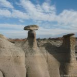
After you have scaled the steep hillside, you will need to climb up to get to the mesa top. There is no good or easy way to do this. We ended up scrambling up some boulders and through a narrow “slot” in the canyon wall, then took a round-about route to the left, scrambling up some more boulders to get to the top of the mesa. You will have to use your good sense to get you through this, as I can’t really direct you on how to do this best. Once you have reached the mesa top, stroll south over the somewhat flat ground to where you can get terrific views of Lake Powell and the area surrounding you. It’s so pretty! You can also stroll right along the mesa for a ways, which, although you probably won’t get that much different a view, can be fun. Be careful, though: there aren’t any guard rails, and it’s a very long way down! Another interesting feature is the number of geodes we found in the area. They are all over the ground on the top of the mesa, broken in little pieces, in slices (my favorite), and even a few that haven’t broken open at all yet. We found these fascinating. Return by the way you came. A little farther to the north from the mesa top is a canyon with some more fallen arches if you’re interested in such things.
 from (or to) the mesa top")
Climbing down (or up) from (or to) the mesa top
So now I’ve made this sound like a really difficult hike up to a nice view. Well, it certainly isn’t for the faint of heart, but if you’re in good shape you should be able to do it (provided you have a good dose of common sense). Like every other hike in the wilderness, you need to use your experience from other hikes like this to get up the difficult sections. For example…always test your handholds and footholds before you use them. As I mentioned above, the sandstone is very soft and breaks easily. By testing your hand- and footholds, you will have less of a chance of falling.
Fees: None
Trail 
Road
Signs
Scenery
Would I go 100 miles out of my way for this?
Overall Rating:
This Week’s Featured Product!
The area around Grand Staircase-Escalante and Glen Canyon is beautiful, with so much to discover. This book covers almost 60 hikes through the area.


Greetings! This is my first visit to your blog! We are a team of volunteers and starting a new initiative in a community in the same niche. Your blog provided us valuable information to work on. You have done a extraordinary job!
Very nice article. I certainly appreciate this site. Keep writing!
Hi, and thank you for the useful info . Keep me updated through email when you have new posts.
Thank you
Cheers from rainy Vancouver, Canada
Pingback: Anne's Travels » 10 Reasons I Choose Dayhiking over Backpacking
Pingback: The Best of Anne's Travels in 2015 - Anne's Travels