
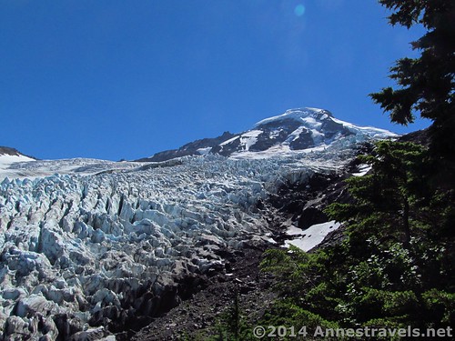
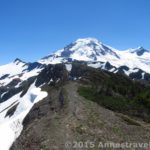
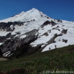
Mount Baker and the Coleman Glacier from the “end” of the Heliotrope Divide Trail
If you want a jaw-dropping view you don’t get most other places, try the Heliotrope Divide Trail on the side of Mount Baker in Washington. Seriously. The trail itself may not be that exciting (save for the four stream crossings), but at the end is a view you won’t easily forget. A huge glacier spreads upward, beautiful yet ugly blue crevasses pitting the surface in neat yet natural streaks up the side of the snow. After the shock of the glacier, look up to the cone of Mount Baker, or ‘way across the valley to the waterfalls that roar out from beneath the ice and snow. Really: you don’t want to miss this one (especially at 6.5 miles (10.4 km) RT).
Quick Stats
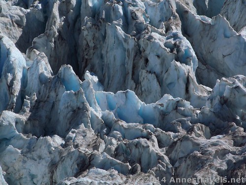
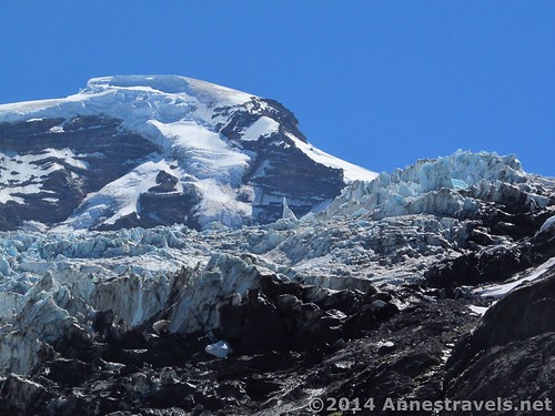
Close-up on some of the ice and crevasses
I hadn’t actually planned to hike Heliotrope Divide on my last visit to the Mt. Baker area (early August 2014), but two things pushed me over the edge. #1, it was listed on the “Stunning hikes near Mount Baker” page on the WTA site (http://www.wta.org/go-hiking/seasonal-hikes/summer-destinations/stunning-hikes-near-mount-baker). #2, a very nice man we met on the trail recommended it to us. He also said that the river crossings were waste deep, but we found we could generally get across without getting our feet wet. After those two recommendations, and with another day in the area, I knew we could do it – and I’m so glad we did!
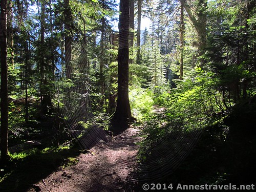
Interesting spider web along the trail. Because we were the first hikers of the day, the people in front would end up with tons of spider webs in their hair by the end of the trail!
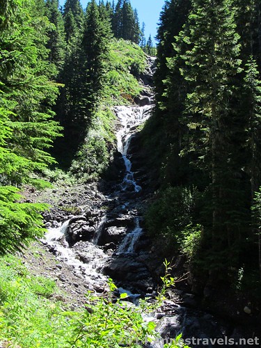
The parking area is the same as for the trail to the summit, so you’ll likely see the outfitter vans in the parking lot. The trail quickly descends into the forest, enters the Mt. Baker Wilderness about 0.1 miles (0.1 km) later, then crosses a stream via a very impressive bridge. It then winds slowly upward, heading generally toward Mt. Baker (which is out of view). The first exciting part of the trail is at 1.4 miles (2.25 km), where it crosses a small creek under a lovely waterfall. Don’t get your hopes up too quickly, though: this is an easy stepping-stone crossing, nothing like the ones ahead!
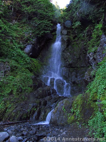
Waterfall at the creek crossing
At 1.6 miles (2.5 km) we came to the first stream crossing. This is actually one of the easier crossings; we did it ok hopping from stone to stone and crossing on logs. I won’t say it was easy, but it wasn’t too bad either – we got everyone across, and considering the age/agility of some of our members, I think that’s quite the feat! Hiking poles are helpful!
First stream crossing. This hiker is trying to decide if it’s easier to cross further up (which, he decided, it’s not).
After the first stream crossing, the trail headed upward, passing a very nice waterfall view at mile 2.25 (3.6 km). About 0.05 miles (0.05 km) beyond this, a trail to a wilderness toilet goes off on the left. 0.2 miles (0.3 km) beyond the toilet trail came stream crossing #2: a bit more difficult, but still not so bad. Everyone got across just fine, and we continued up the trail.
The waterfalls
Only 0.3 miles (0.4 km) beyond the second stream crossing, we came to the only real trail junction: that of the Climber’s Camp Trail and the Glacier Trail. Turn left, following the sign (if you can find it) for the Glacier Trail.
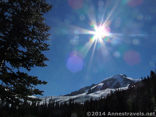
Playing around with the camera and taking pictures of the sun (an Mount Baker) near the Glacier Trail / Climber’s Trail Junction.
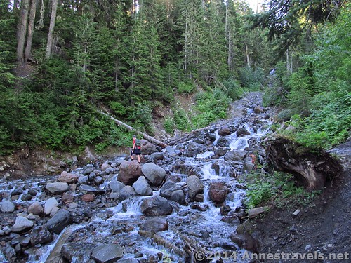
Fairly quickly after this (0.1 miles and 0.3 miles (0.1 km and 0.4 km), respectively) are the last two stream crossings, which are definitely the most exciting. We hung around for a while, trying to find a way that everyone could cross without getting their feet wet. We made it ok, but it wasn’t easy. According to the rangers in the visitor center, none of the stream crossings are really dangerous (like, sweep you away-type dangerous), but it can be difficult to see where you’re putting your feet if you walk right through, which makes it easy to twist and ankle. I didn’t try walking through, but I will say that the water is swift and foamy enough to make it difficult to see how deep it is.
Near one of the final stream crossings – doesn’t look too hard, does it?
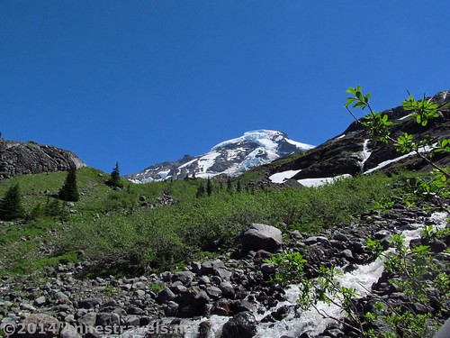
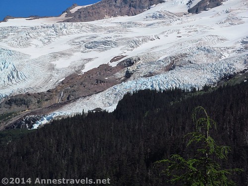
With the last of the stream crossings finally behind us, we joyfully ascended the final ridge (there are a large number of social trails here; take what you deem is the best one) and stopped, staring at the glacier suddenly laid out below us. WoW! I didn’t know the US even had a glacier like this (outside of Alaska) and certainly not on a trail I could dayhike. Double WoW!
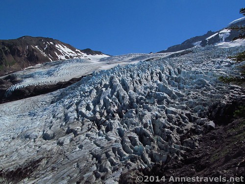
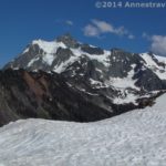
Coleman Glacier
We paused long enough to eat lunch, then continued on the trail up the ridge (really, the trail ends here, but we didn’t know that and probably would have continued even if we had known.) You can get closer to the glacier, although the trail deteriorates the further it goes. Watch your step along the edge of the ridge, too, as it’s fairly eroded.
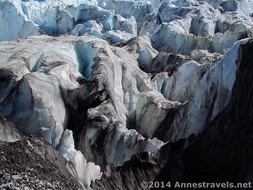
Crevasses near the edge of the glacier
Then we did something I don’t at all recommend you do, and I will likely never do again: several of us descended to the edge of the glacier. Why don’t I recommend it? First, it’s super, super dangerous. At the edge, we found ourselves looking down into crevasses on either side of us – once false move and we’d have been sunk. Secondly, it’s not easy to get to; the route is almost as dangerous as the glacier itself. We found ourselves zigzagging across a steep hillside covered with loose rocks and boulders, sending showers of small rocks down the hillside (can you say “loose footing?!?”) then scrambling over clanking rocks that would bruise your ankles if you as much as touched them. Not fun.
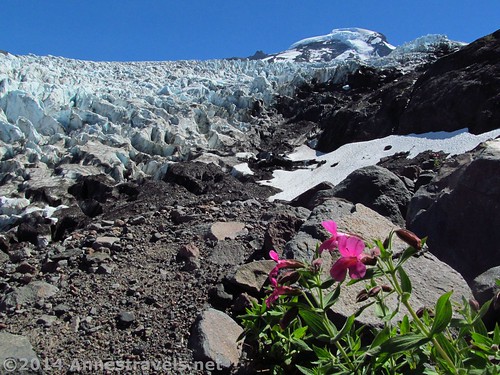
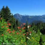
Scrambling down to the glacier – Wildflowers
Finally, at the edge of the glacier, we took a few pictures (to prove we’d been there), looked at each other, and said, “Let’s get out of here!” Usually an adventurous 5-sum, we all realized the danger of the situation and weren’t anxious to stay any longer than necessary. Meanwhile, back on the “trail” (such as it was) the rest of the group was having panic attacks: it looked twice as dangerous from above, apparently!
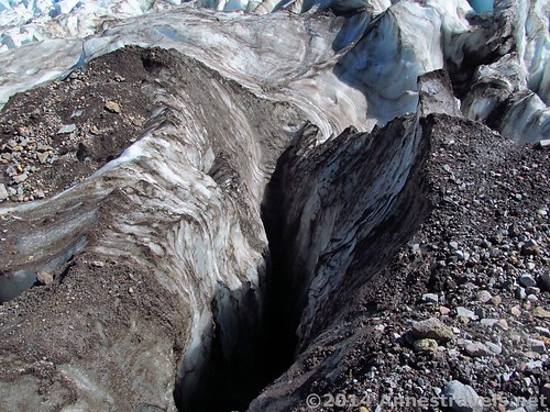
On the very edge of a crevasse
Happily reunited, we still had to cross the streams to get back to the parking area. They were definitely a bit higher (the snowmelt having increased the flow as the day wore on), but we still managed to get across with no more than the bottoms of our feet getting wet on the third and fourth crossings (the ones nearest the Coleman Glacier).
Ice formations on the glacier
Overall? Highly recommended! If you can do the stream crossings, the views of Coleman Glacier are outstanding. I think they’re the favorite pictures we took, too – in some ways, the pictures turned out better than even real life, even if they can’t quite capture the feeling of grandeur!
Round Trip Trail Length: 6.5 miles (10.4 km) to the Coleman Glacier overlook; to the glacier and back ended up being around 7.5 miles (12.0 km)
Lowest Elevation: 3,437 ft. (1,047 m)
Highest Elevation: 5,274 ft. (1,607 m)
Net elevation Gain: 1,837 ft. (560 m)
Fees: $5 per day fee. Northwest Forest Service Pass, America the Beautiful (Interagency), Senior (Golden Age), Access (Golden Access), Volunteer, and Military passes also accepted. Discovery pass is not accepted.
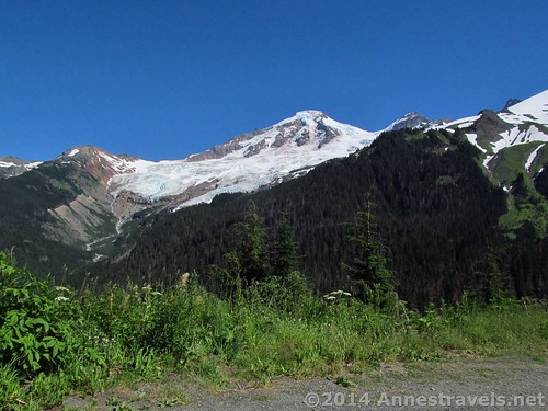
Mount Baker from the road above the Heliotrope Trailhead
Key GPS Coordinates
Heliotrope Divide / Glacier Parking: 48.80201N / -121.89597W (48° 48′ 7.236″ / -121° 53′ 45.492″) (3,437ft.; 5,531 m)
Trail Beginning: 48.80222N / -121.89569W (48° 48′ 7.9914″ / -121° 53′ 44.484″) (3,672ft. 5,909 m)
Enter Mount Baker Wilderness: 48.80135N / -121.89492W (48° 48′ 4.8594″ / -121° 53′ 41.7114″) (3,662ft.; 5,893 m)
Creek Crossing with Waterfall: 48.79804N / -121.87823W (48° 47′ 52.944″ / -121° 52′ 41.628″) (4,360ft.; 7,016 m)
Stream Crossing #1: 48.79832N / -121.87627W (48° 47′ 53.9514″ / -121° 52′ 34.572″) (4,361ft.; 7,018 m)
Waterfall View: 48.79723N / -121.87345W (48° 47′ 50.0274″ / -121° 52′ 24.42″) (4,636ft.; 7,460 m)
Toilet Trail Junction: 48.79698N / -121.87241W (48° 47′ 49.1274″ / -121° 52′ 20.676″) (4,696ft.; 7,557 m)
Stream Crossing #2: 48.79600N / -121.87076W (48° 47′ 45.5994″ / -121° 52′ 14.736″) (4,804ft.; 7,731 m)
Climber’s Camp Trail / Glacier Trail Junction: 48.79527N / -121.86783W (48° 47′ 42.972″ / -121° 52′ 4.1874″) (4,975ft.; 8,006 m)
Stream Crossing #3: 48.79454N / -121.86578W (48° 47′ 40.3434″ / -121° 51′ 56.808″) (5,061ft.; 8,144 m)
Stream Crossing #4: 48.79431N / -121.86381W (48° 47′ 39.516″ / -121° 51′ 49.716″) (5,127ft.; 8,251 m)
Glacier Overlook: 48.79465N / -121.86256W (48° 47′ 40.7394″ / -121° 51′ 45.216″) (5,190ft.; 8,352 m)
On Glacier: 48.79362N / -121.85995W (48° 47′ 37.0314″ / -121° 51′ 35.8194″) (5,274ft.; 8,487 m)
The gpx file for Heliotrope Divide can be downloaded – please note that this and the GPS Coordinates are for reference only and should not be used as a sole resource when hiking this trail.
Download File size: 137.7 KB Downloaded 628 times
(Note: I do my best to ensure that all downloads, the webpage, etc. are virus-free and accurate; however, I cannot be held responsible for any damage that might result, including but not limited to loss of data, damages to hardware, harm to users, from use of files, information, etc. from this website. Thanks!)
Yes, we was on that thar glacier! From the road above the trailhead.
Zoom map out to browse nearby hikes & places of interest
Getting to Heliotrope Divide
From the Glacier, WA ranger station, drive 0.7 miles east on the Mount Baker Highway. Turn right onto Glacier Creek Road (National Forest Road 39). Drive 7.8 miles on NF-39; turn left onto a side-road to the parking area after 0.3 miles. Actually, if you continue up the road you can get to “Baker View” (at the end of the road) which doesn’t have good views of Baker at all, but the views from the road are fabulous!
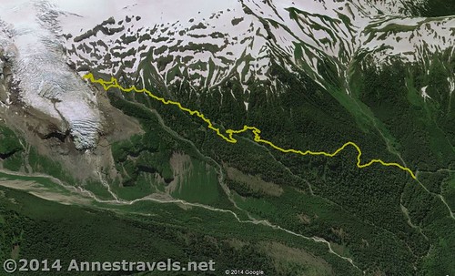
Visual map of the Heliotrope Divide Trail – note that north is down (the maps worked better that way!)
This Week’s Featured Product!
There are so many great hikes in this book, including in the Mt. Baker area.
Pingback: 6 Best Hikes on the Mt. Baker Highway - Anne's Travels
Pingback: 10 of the Best Trails In and Around North Cascades National Park - Anne's Travels
Pingback: 15 Must Do Waterfall Hikes Across the US - Anne's Travels
Pingback: A Foretaste… - Anne's Travels
Pingback: Welcome to Anne’s Travels’ New Look! - Anne's Travels