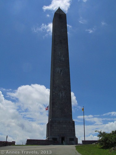
The entrance to the NJ Highpoint Monument
After hiking to the highest point in Oklahoma in May, we all decided that the highest point in the state of New Jersey was “high” on our must-do list when we visited that state in July. High Point State Park is almost not in New Jersey; it’s just across the New York boarder and is close to Pennsylvania, as well! There is also a $20 fee to enter the park – unless you like to hike. Walk-ins are not charged a cent, and since the Appalachian Trail goes nearly to the high point monument, it’s a nice little stroll (ok, hike) on a famous trail. In this post, I’ll detail our trek up to the monument, which really is impressive and fun – if you’re not afraid of heights! Viewing areas allow you to see the monument from far away as well as close-up as you climb the 291 steps to the top.
The place the AT reenters the woods across the road from the ranger station
We set out on a hot day in July, hoping for a nice hike and then to take a swim in Buttermilk Falls when we got back. (We spent more time than planned hiking, so we ran through the sprinkler instead, which still felt good.) On the first try, we missed the trailhead, but it didn’t take us long to realize our mistake and backtrack. The parking area was large, so we didn’t have any trouble finding a shaded parking place, even though it was Independence Day. The trail begins near the signboard, which should have a map of the area. This trail is actually a connector trail that will take you to a State Park trail, which will take you to the AT.
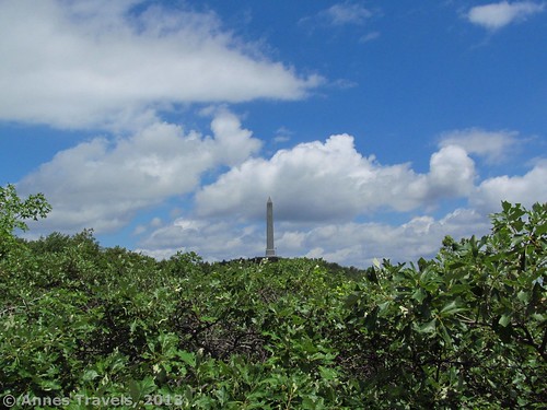
The High Point Monument rises above the trees
At first, the trail was great, and we made good progress. However, the further we went (and especially after we turned right when we reached the State Park trail – aka the Iris Trail) the trail became muddier and muddier; in places there was standing water. I’m assuming this was because of the amount of recent rain, but it was still annoying. On the way back, we skipped this section all together and walked along the road for a short distance back to the parking area. You’ll want to turn right again at the junction with the AT (white blazes).
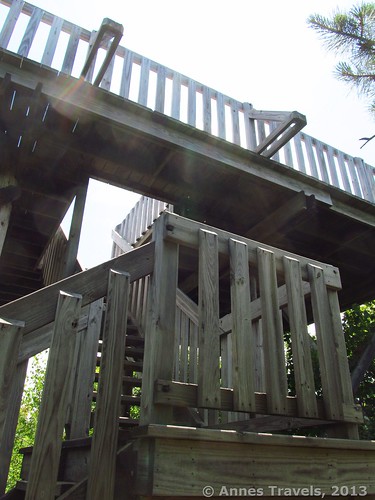
The Lookout Tower
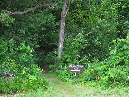
Finally, we left the mud behind as the trail emerged from the trees behind a signboard. On your left will be the High Point State Park ranger station. Cross the grassy section near the ranger station’s driveway; then cross the road. Keep heading straight toward the woods on the other side of the grassy field, staying well right of the High Point State Park sign. About half way across the field, you will be able to spot the place where the AT reenters the woods. A sign does mark this junction, but it’s not easy to see from far away.
From here, the trail is very typical AT: rocky, through the woods, some scrambling up large rocks but never having to use your hands. It was a very pleasant hike; I deeply enjoyed the peacefulness of the woods and the naturalness of the rocks and trees. We met a few other hikers (mostly dayhiking) although we did see a few through-hikers.
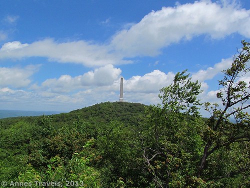
The view of High Point from the Lookout Tower
Finally, when we thought we must be getting someplace-or-another, the trail broke out of the trees. On the right was a nice view, and as we continued hiking we caught glimpses of the high point monument between the trees. Then, as we rounded a corner, a large, wooden structure appeared beside the trail. Climbing the stairs to the top, we discovered a viewing platform with a wonderful view of the surrounding area. The high point monument was in full view now, as well as the hills and valleys surrounding High Point State Park. I highly recommend that you climb to the top of the viewing tower.
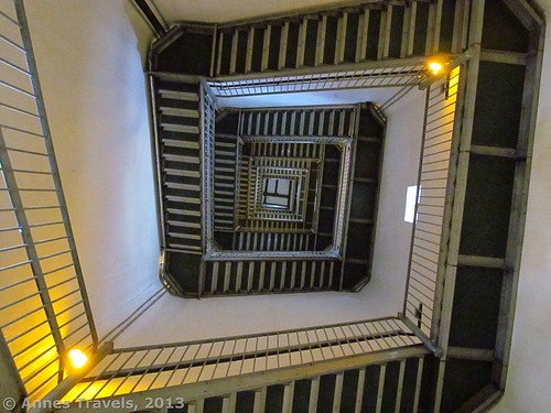
The stairs spiral upward
Continuing down the trail, we soon encountered a trail junction. Here the AT (and its white blazes) takes a sharp turn to the right while a blue/aqua blazed trail turns slightly to the left. Take this left fork; it is the Monument Trail, a side trail that will take you to the highest point in New Jersey (the AT does not cross the high point).
The Monument Trail continues to climb upward, crosses the road, and then keeps climbing steadily around the hill. The trail dramatically improves after the road crossing; instead of a rough-hewn trail similar to the AT, it has a gravel tread and is wider. As you walk, you will pass the lights that illuminate the high point monument at night.
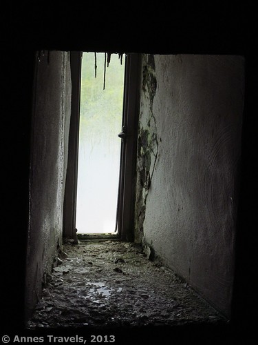
Some of the windows inside the monument have stalactites from the dampness
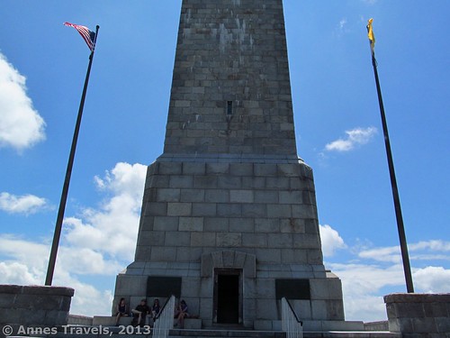
Then, sooner than we thought was possible, we stepped out of the trees and found ourselves only steps away from the monument itself. However, as you’re coming out on the side, you will need to circle around toward the front of the monument to access the steps and enter the monument itself. As much as there is handicap parking, the monument has no ramps and is pathetically not equipped for handicapped visitors.
We quickly ascended the steps and entered the cool of the monument. A state parks ranger on duty smiled at us and then went back to what she was doing at her desk. On the walls hung signboards about the park, the family that once owned and land, and the monument. However, we skipped these and quickly walked over to the spiral staircase the wound upward.
The room at the top of the monument
The first set of stairs is less than 20 steps; the spiral staircase leads to a landing. From here, look up. Above you is over 250 concrete stairs rising skyward around the walls of the monument. It’s amazing, and a photographer’s dream. We kept walking upward, upward, upward, pausing only to take pictures and rest a second before starting up another flight. One warning: the air inside the monument is very damp, and in July it was also fairly warm. We were all sweating before we were halfway up, and by the time we reached the top, water was literally dripping down our arms, legs, and faces.
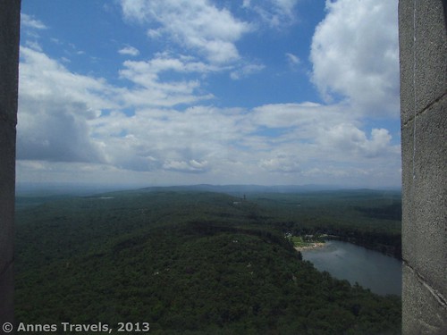
But the top was not an anticlimax. The windows were a bit fogged (or dirty; not sure which), but they also offered those tall enough to see out of them views of New York, Pennsylvania, and far into New Jersey. Port Jervis, New York is visible, as is the Delaware River. I say “tall enough” because those shorter than about 5 feet (1.5 m) needed a helping boost to see out the windows, which are set high into the walls. There isn’t a ton of space at the top, but 10 of us seemed to fit all right as long as we didn’t all want to look out the same windows at once (though the closeness of the air made it seem more crowded than it actually was).
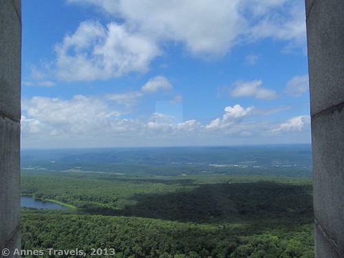
A view out one of the windows at the top
We climbed back down the stairs and ate lunch on the benches outside the monument. Restrooms are located down in the lower parking area. There are also picnic tables with nice views near this parking area. We decided to take the road back to the trail down, then retraced our steps from the road crossing mentioned earlier back to the ranger station along Rt. 23. There, instead of slogging through the mud again, we turned left down the road, followed the guardrail to its end, and then hiked along the road back to the entrance to the AT parking area. This was much simpler than taking the trail, although for those who want a real hike, the trail would be better.
It was a nice hike and an exciting accomplishment: our second state high point in a year!
Round Trip Trail Length: About 4 miles (6.4 km), depending of if you take Rt. 23 back to your vehicle (a little longer) vs. the Iris Trail, and other factors
Facilities: Restrooms at the ranger station and at the High Point parking area
Fees: None. If you decide to drive to the top of High Point State Park, you’ll be charged $10 on weekdays ($5 for NJ residents) and $20 on weekends/holidays ($10 for NJ residents). Fees are only charged Memorial Day weekend through Labor Day.
Trail 
Road
Signs
Scenery
Would I go 100 miles out of my way for this?
Overall Rating:
Getting to High Point State Park Free Parking Area:
Another window view from the top
From I-84, take Exit 1. If you’re on I-84 W, take the exit, turn left on State Hill Road; then (0.2 miles (0.3 km) later) turn left on State Route 23 S and drive 4.7 miles (7.5 km) to the AT parking area on your right (you will pass the High Point Ranger Station just before this gravel road). If you’re on I-84 E, take the exit and turn left on State Route 23 S. From here, drive 4.5 miles (7.2 km )past the High Point Ranger Station to a road on your right that should be marked with a sign about AT parking. This gravel road is just before the large stone “gates” on either side of Route 23 and just before Milepost 48.
If you’re coming from Sussex, drive about 8 miles (12.8 km) north on State Route 23. The parking area (at the end of a gravel road) will be on your left just after passing between two stone “gateways” on either side of the road, just beyond Milepost 48. If you come to the ranger station on your left, you’ve gone too far.
Key GPS Coordinates for Hiking to the Highest Point in New Jersey:
The High Point Monument from the lower parking area
Entrance to AT parking area on Route 23: 41.30341N / 074.66674W
Appalachian Trail Parking (parking area for this hike): 41.30260N / 074.66774W
Beginning of connector trail: 41.30260N / 074.66774W
Connecting Trail/Iris Trail junction: 41.30203N / 074.67071W
Iris Trail/AT junction: 41.30340N / 074.67182W
AT leaves the woods near ranger station: 41.30577N / 074.66943W
AT reenters the woods across the road from the ranger station: 41.30579N / 074.66943W
Viewing platform: 41.31679N / 074.66454W
AT/Monument Trail junction: 41.31857N / 074.66355W
Road crossing: 41.31943N / 074.66345W
High Point Tower Entrance: 41.32100N / 074.66157W
High Point: 41.32104N / 074.66158W
The gpx file for the New Jersey Monument Trail can be downloaded (out and back) – please note that this is for reference only and should not be used as a sole resource when hiking this trail.
Download GPS File File size: 39.9 KB Downloaded 158 times
Download GPS File File size: 52.0 KB Downloaded 180 times
(Note: I do my best to ensure that all downloads, the webpage, etc. are virus-free and accurate; however, I cannot be held responsible for any damage that might result, including but not limited to loss of data, damages to hardware, harm to users, from use of files, information, etc. from this website. Thanks!)
This Week’s Featured Product!
If you want to know more about finding your own food in swamps, fields, and other natural areas, this is an excellent resource. Full-color photographs are supplemented with engaging text for an enjoyable and informative read.