
Standing under the span of Indian Rock Arch
On our recent visit to Yosemite, there were a few “must do” hikes on my list along the Tioga Road, namely, Cloud’s Rest and North Dome. Actually, the dome didn’t interest me as much as a photo I had seen of a little arch of white-and-colored-lichen rock, apparently called “Indian Rock”. (It’s actually a lot larger than the photos make it look, but that’s another story.) Since the arch was technically on the way to the dome, it seemed like a great little dayhike… and hopefully the crowds and snow wouldn’t be as bad as the valley (crowds) and higher on the Tioga Road (Mono Pass didn’t look so promising).
Quick Stats for the Trail to Indian Rock
That looks like a pretty cool arch!
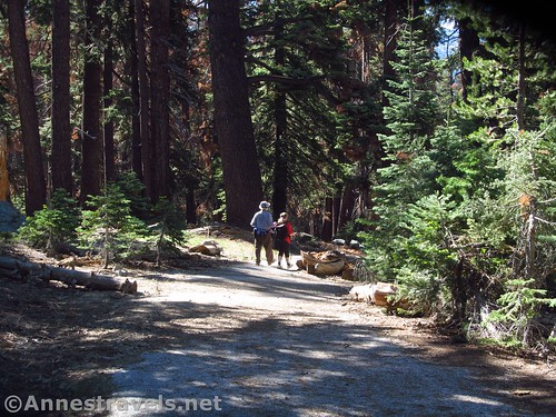
So we started off down the trail – really, an old road – late in the morning (EDT it was late), having driven in from the Virginia Lakes before starting the hike. The road is steep for a road, though not too bad for a trail, as it descends 0.75 miles to the site of an old campground. When I hiked the trail, there were a few trees across the road. I’m guessing these will have been care of by the park service once the snow melted out.
Descending the old road
Turn right to find the double stream crossing, then continue along the trail.
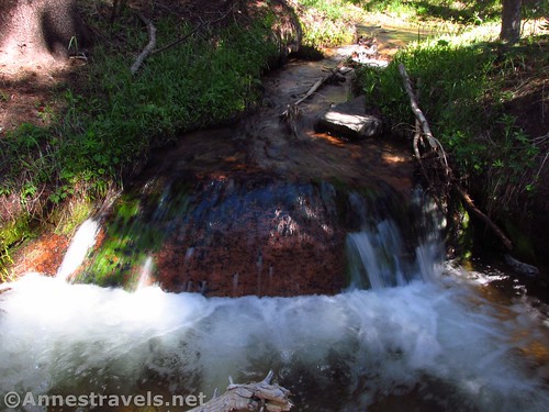
Waterfall at the stream crossing
Now, the trail goes up a north-facing slope, so this next section was the only one with snow on the hike (the Tioga Road had opened two days before). It wasn’t hard to find the trail, even if it was a bit of up-and-down over snow piles as the trail goes through a pine forest.
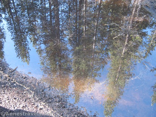
Reflection of the pines in a snow-made puddle along the trail
The next point of interest was at mile 2.0. Here the trail junctions with the trail to Mirror Lake. Turn right, following signs for North Dome. Only 0.05 miles later, turn left toward North Dome at a junction with trails heading toward Yosemite Valley. Really, these trails are just a bit confusing; everything seems to lead to the Valley sooner or later!
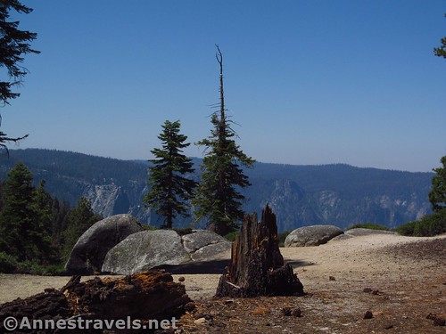
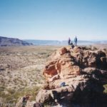
Part of the viewpoint along the North Dome Trail
Shortly after the trail junctions, a well-trampled trail / campsite appears on right (you won’t miss it). Go this direction, around some rocks, and then up on other rocks for a nice view out toward the Valley.

Views from the rocky viewpoint
Continue on the trail through the thinning pine forest. It now heads uphill fairly steeply. Don’t worry, this is the last real push before North Dome, though Indian Rock has one more steep ascent.
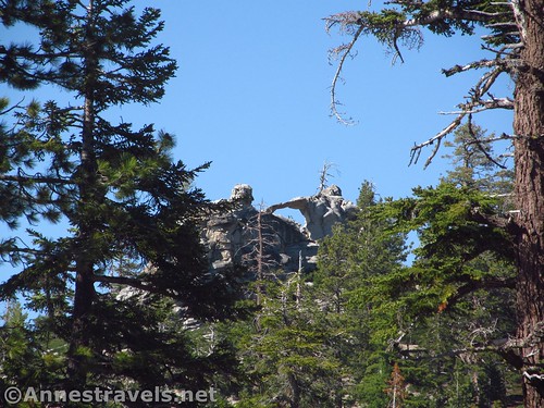
Indian Rock looks pretty good from the North Dome Trail, too
At 3.3 miles from the trailhead, the unassuming trail junction indicates Indian Rock, 0.3. (I’ve never personally been a fan of these cut metal signs, but whatever.) Turn left here up the nowhere-near-as-traveled trail.
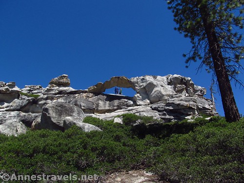
First glimpse of the arch – that’s what you’re heading for!
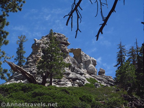
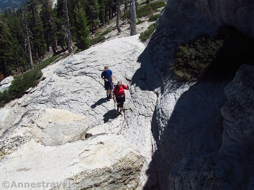
The trail wanders for a very short distance, then begins to climb in earnest. It looks like people have either lost the trail and made their own, or the trail isn’t very well defined. Either way, it’s a very steep 0.25 miles up 200ft. of elevation gain. The good news is that the arch fairly quickly comes into view on the left and above you, so at least you know what you’re heading for!
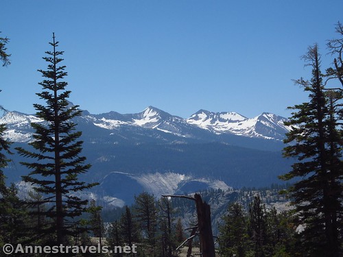
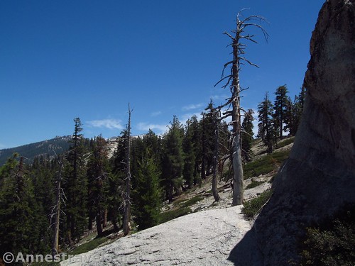
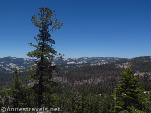
The snowy Sierras from the trail to the arch
Below the arch, plenty of people have headed up to Indian Rock via a number of social trails. I did it, and it’s not a bad scramble. But for an easier trek, continue on the trail behind the arch, then turn left. It’s not quite a stroll in the park, but much easier than scrambling up the front.
You actually can scramble up the front of the arch if you want…
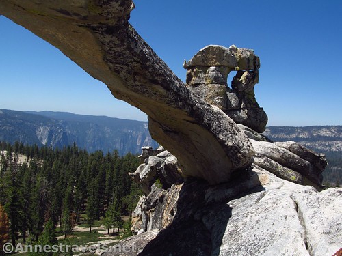
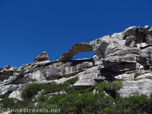
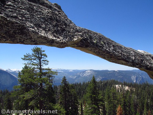
Indian Rock is like no other arch I’ve ever seen, especially outside of Utah. It’s amazing that this span could stay up, it’s so thin, and to sit beneath it and look out to the snowcovered Sierras and the cliffs of Half Dome is just incredible.
…but it might be easier to go around the back
We were the only visitors to Indian Rock when we arrived, although I think we might have met one or two people coming up as we were heading back down. And that compared to the crowds of backpackers (nothing like the Valley, but still plenty of people) along the North Dome Trail.
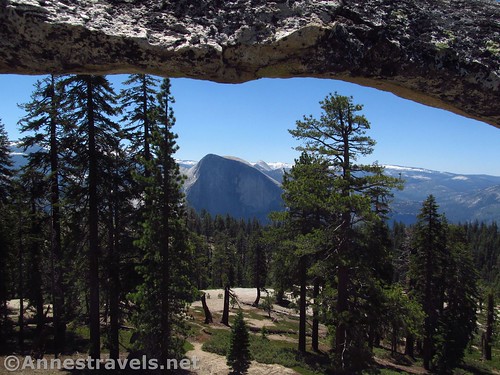
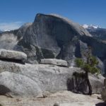
Half dome from under the arch
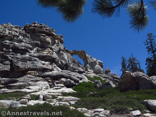
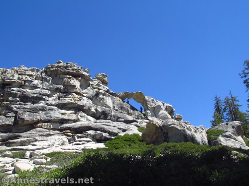
Technically, Indian Rock is the only arch in Yosemite. Which spurred my group to point out every arch they discovered the entire time they were in the park (there were lots; there’s even a second arch right next to Indian Rock!) So maybe it’s safer to say that it’s Yosemite’s only named, marked-on-the-map arch…
See? There’s another arch just to the right of Indian Rock!
We enjoyed the view and the shade of the rocks while we had our first lunch (too many years of forgetting lunch has prompted jokes about packing two lunches), then headed back down, carefully avoiding the rattlesnake we had seen earlier, sunning itself on a nearby rock.
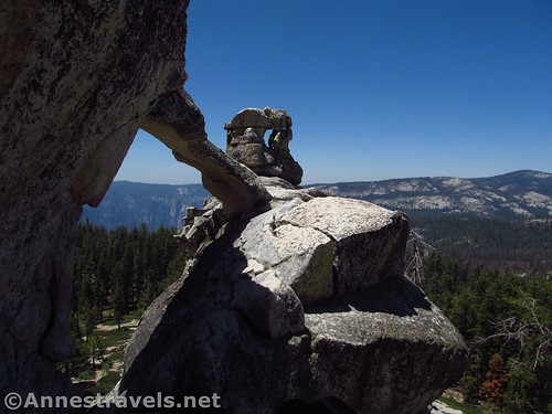
Views to the north, toward the actual summit of Indian Rock
At the trail junction, we turned left to go over to North Dome, and even if you don’t want to go to the Dome itself, it’s worth hiking another half mile or so to the first really good viewpoint. But North Dome is a post under its own…
To give some perspective… three people in the arch
Round Trip Trail Length: About 6.6 miles to Indian Rock. North Dome for me was about 11 miles RT
Net Elevation Change: 489ft. (7,810ft. at Porcupine Creek to 8,299ft. at Indian Rock)
Facilities: Primitive restrooms at the trailhead
Fees: $30 per vehicle, valid 7 days. Yosemite Annual and America the Beautiful Interagency Passes (Annual, Access, Senior, Military, 4th Grader, Volunteer) also accepted.
Trail Notes: Apparently the one north-facing slope (just after the Porcupine Creek crossing) melts slower than the rest of the trail. There are plenty of backpackers on this trail in season, along with a good number of day hikers, though it’s nothing like the valley and you will get a decent amount of privacy (especially after the Indian Rock Trail junction). The last 0.25 miles of the trail can be a bit of a find-the-trail game, but not so much that you can’t figure it out if you can see where the arch is.
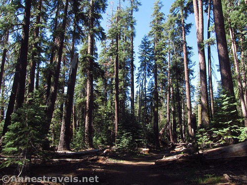
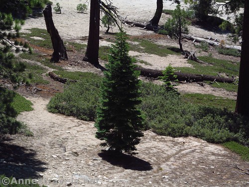
The trail through the pines
Trail 
Road
Signs
Scenery
Would I go 100 miles out of my way for this?
Overall Rating:
Indian Rock Span
Key GPS Coordinates for Indian Rock
Porcupine Creek Trailhead: 37.8065056°N, -119.5451722°W (37°48’23.42″N, -119°32’42.62″W / 37°48.39033’N, -119°32.71033’W) (8,133ft.) (0.0; ended 8.27, but that’s wrong)
Enter Wilderness: 37.7993778°N, -119.5482667°W (37°47’57.76″N, -119°32’53.76″W / 37°47.96267’N, -119°32.89600’W) (7,836ft.) (0.71)
Mirror Lake Junction: 37.7869000°N, -119.5586861°W (37°47’12.84″N, -119°33’31.27″W / 37°47.21400’N, -119°33.52117’W) (7,881ft.) (2.05) (Go right)
Yosemite Falls Junction: 37.7866056°N, -119.5589028°W (37°47’11.78″N, -119°33’32.05″W / 37°47.19633’N, -119°33.53417’W) (7,877ft.) (2.10) (Go left)
Viewpoint: 37.7820417°N, -119.5604417°W (37°46’55.35″N, -119°33’37.59″W / 37°46.92250’N, -119°33.62650’W) (7,916ft.) (2.46)
Indian Rock Trail Junction: 37.7755778°, -119.5565000°W (37°46’32.08″N, -119°33’23.40″W / 37°46.53467’N, -119°33.39000’W) (8,108ft.) (3.31; return 3.97) (Left to Indian Rock)
Indian Rock: 37.7763500°N, -119.5536083°W (37°46’34.86″N, -119°33’12.99″W / 37°46.58100’N, -119°33.21650’W) (8,299ft.) (3.5)
A lone pine grows in the rock below Indian Rock
The gpx file for Indian Rock and North Dome can be downloaded – please note that this and the GPS Coordinates are for reference only and should not be used as a sole resource when hiking this trail.
Download GPX File size: 234.0 KB Downloaded 155 times
(Note: I do my best to ensure that all downloads, the webpage, etc. are virus-free and accurate; however, I cannot be held responsible for any damage that might result, including but not limited to loss of data, damages to hardware, harm to users, from use of files, information, etc. from this website. Thanks!)
People in Indian Rock Arch
Getting to the Indian Rock Trailhead
From Lee Vining (US-395 on the east side of the park), turn west onto the road into Yosemite, more technically known as the Tioga Pass Road. Signs should point toward Tioga Pass and Yosemite National Park. Drive 33.7 miles to the trailhead for Porcupine Creek, on left.
Looking west from the arch
From the El Portal Road in the Valley or coming from El Portal, turn onto Big Flat Road toward CA-120 and Tioga Pass. After 9.5 miles, turn right in Crain Flat, following signs for Tuolumne Meadows and Tioga Pass. Drive 24.9 miles to the Porcupine Creek Trailhead, on right.
The parking area is none too large. I recommend getting their fairly early during the summer months (I think we pulled in about 8am on a Saturday of a holiday weekend, and there were still parking spaces, which there weren’t when we returned about 5pm).
Zoom map out to browse nearby hikes & places of interest
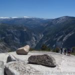
Visual trail map and elevation profile of my hike to Indian Rock Arch
This Week’s Featured Product!
If you need even more inspiration for day hikes in Yosemite, check out this book with up to 80 day hikes, ranging from easy strolls to all-day hikes.
[forecast location=”Lee Vining, CA” caption=”Weather for Indian Rock” measurement=’F’ todaylabel=”Today” datelabel=”date(‘D M d’)” highlow=’%%high%%°/%%low%%°’ numdays=”5″ iconset=”Default”]


Pingback: Sneak Peak: A California Trip through Desert and Snow - Anne's Travels
Pingback: Spectacular Views from Yosemite's North Dome - Anne's Travels
Pingback: When I Fell in Love with the Mountains - Anne's Travels