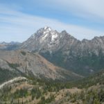
Mt. Stewart from off the trail at Ingalls Pass
The Teanaway region of Washington is beautiful (I think I said that in another post, but I’ll say it again here because it’s true…it’s lovely!). However, almost any region has its trails that are really hyped up, but actually don’t give you what you were expecting. Ingalls Pass fits this description nicely. There are views from the pass, but they’re not the incredible scenery you can get elsewhere. It is actually just a point where those continuing on to Ingalls Lake can cheer, “Hurray! It’s all downhill from here to the lake” or on the way back, “Yippee! It’s all downhill from here to the parking lot!” Still, you can get some pretty good views of Mt. Ingalls, so if you’re looking for a day hike and have done everything else in the area, read on. The trail to the pass and back down is about 6 miles round trip.
The parking area for this hike is the same as for Longs Pass and several other trails that make their way up the Teanaway Valley. To get to this trailhead, from I-90 take exit 85 (South Cle Elum) and head east (north) on Hwy 970. Alternatively, from Hwy 97 south, turn right onto Hwy 970. Either way, you will want to turn north (that’s left if you’re coming from I-90; right if you’re coming from Hwy 97) onto Teanaway Road. Drive approximately 10 miles to the 29 Pines Campground, at which point the road will become gravel. I didn’t see any sign that said “29 Pines Campground”, but there is a campground at this point. Here the road changes names to Forest Road 9737. Keep driving on this road to its end. At the end of the road you will find a good-sized parking area, a primitive restroom, a couple of picnic tables, and a signboard. The parking area can fill up very quickly on weekends. We arrived Friday night, and the place was already packed (we were very thankful to get a parking place when another hiker pulled out). By the end of the next day, when we came back from the hike, the parking lot was full, with several cars parked in the middle where there are no parking spots, and more than 50 cars parked down the sides of the road. All that to say, come early on weekends, or be prepared to walk!

The trail as seen from the pass
Even though the road is gravel, it is passable by low-clearance vehicles. There are many spots to camp along the way, as well as several primitive campgrounds. (In other words, the campgrounds have primitive restrooms (but no water), so you have to pay for them.) The road follows a stream, so many people come out on the weekends (and on weekdays) to camp, fish, hang out, have family reunions, etc. Some areas are closed to camping, so if you’re planning on camping in a non-developed (free) campsite, watch for the signs on trees that say things like, “No camping next 2 miles”. On weekdays, the road is also used by a logging company. Be aware that the logging trucks are active, so watch out for them as you drive down the road. The road is also very dusty, so keep your windows closed and try not to get behind other cars (if you can help it). Numbers on trees sometimes mark the miles and half miles along the road.
Before I begin telling you about the hike, let me start out by saying that if you’ve only got so much time to take a hike here, you’d be better off going up the Longs Pass Trail instead of up to Ingalls Pass. It feels like a shorter hike, even if the mileages are actually the same, and the view is much more rewarding. Still, if you’re up to it, Ingalls pass is nice enough, and doing both passes can be rewarding. I did Longs Pass and then continued up to Ingalls Pass. If you’re really up to it, you can continue down over the other side of Ingalls Pass over to Ingalls Lake (a popular destination for day hikers and backpackers alike). By the time we made it up to the pass, it was too late to go down to the lake, so we turned around. Maybe we’ll actually make it to the lake on another trip.

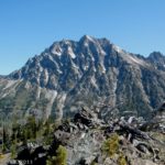
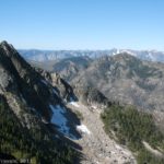
Mt. Ingalls from Ingalls Pass
The trail begins near the signboard at the edge of the parking area, and it immediately begins to climb upward through a pine forest. Part of the trail is an old mining road; this will become more obvious after you take the turnoff for Ingalls Pass. After 0.25 miles, the trail will split. You want to turn right towards Longs and Ingalls Passes. Be aware that dogs are not allowed on this trail, for whatever reason. There are some large signs that explain this at the trail junction. Dogs are allowed of you go straight, down the trail to Esmeralda Basin and Fortune Creek Pass.
From the trail split, the trail continues to ascend, often quite steeply, across what appears to be an old moraine. There are few trees here, so it’s a pretty exposed trail. The trail is very dusty because you are walking across rocks and dirt. It’s not a hard hike except that it’s pretty steep. The day we hiked the trail, it was an unusually hot day in August. By noon the sun was scorching down on the trail. If the day is supposed to be hot, start out very early in the morning. We were on the trail by 6:00, and the trail was still in the shadow of the mountains. This made it much more comfortable walking until the sun got high enough to shine on the trail.

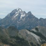
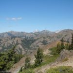
Looking back into the Teanaway Valley
After 2 miles, the trail will split again. The left trail heads up towards Ingalls Pass, while the right trail goes to Longs Pass. A sign marks the junction. Keep going straight (left) up towards Ingalls Pass. From here the trail really begins to climb, continuing across the old moraine. It switchbacks its way up, occasionally crossing small streams that tumble down the moraine. Eventually you will enter some scrub trees, which offer a little shelter from the sun. The last 0.3 miles up to the pass are probably the steepest, as the trail takes short, steep switchbacks as it zigzags up to the pass. This is about 3 miles from the trailhead. However, to me, it felt longer. It only took us a couple of hours to get from the parking area to the top of Longs Pass, but to get back down to the Ingalls Pass/Longs Pass trail junction and then up to Ingalls Pass took us at least three hours. There were plenty of people on the trail, most of them headed over the pass to Ingalls Lake or to set up an overnight camp on the other side of the pass (backcountry camping pass required).
")
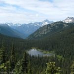
The approximate location of Lake Ingalls (in a cup in the light-colored rock)
When you get up to the top, you will be surrounded by boulders. The trail heads over to the left along the top of the ridge towards a signboard nailed to a tree. If you’re looking for a view, either keep going straight across the rocks that surround you when you first come up into the pass, or head along the trail for a short while along the top of the pass and then climb up onto the rocks on your left. From here you get a very nice view of Mt. Ingalls, over on the left if you’re facing the way you were when you first came up into the pass. You can also see Stewart Pass directly ahead of you. Mt. Stewart is obscured at this angle, but you can see it if you scramble over rocks to the other side of the pass.
From here, you can either go all the way down the other side of the pass to Ingalls Lake, or you can return the way you came. I didn’t do it, but pictures I’ve seen of the lake are very beautiful, with Mt. Stewart reflected in the still water. So if you’re really into mountain lakes, this would be a great option. If you opt not to do it, go ahead and retrace your steps back to the parking area.

Trail map for Ingalls Pass
So, now you have my opinion of Ingalls Pass: nice, but not as nice as other hikes in the area. However, if you’ve hiked it and really like the pass, please let me know in the comments section below this post!
Round Trip Trail Length: 6 miles (felt like more)
Facilities: Signboard, primitive restrooms, and a couple of picnic tables at the parking area
Fees: $5 per day fee (make sure you pay, as they check this parking area!). Northwest Forest Service, Interagency, Senior (Golden Age), and Access (Golden Access) Passes also accepted (leave in hanger (proved when you bought the pass) on rearview mirror).
Trail 
Road
Signs
Scenery
Would I go 100 miles out of my way for this?
Overall Rating:
This Week’s Featured Product!
I put several hikes in the Teanaway Region into this book about day hiking in Washington! The book focuses on trails with views, so be sure to check it out.