
Linkins Lake, CO
Independence Pass in Colorado is a beautiful area. Many 13ers and 14ers stand straight and massive around it, and alpine meadows and lakes set off the mountains’ craggy slopes. So, when we had a few hours to kill while traveling between Leadville and Aspen, a hike near Independence Pass seemed perfect. The trouble was, where do we want to hike? We finally pulled into a parking area on the west side of the pass and decided to try out the trail. Turns out, Linkins Lake is only 0.7 miles (1.1 km) from the trailhead. This fairly large (by alpine standards) lake is in a lovely setting, while the hike up offers gorgeous views of the valley below and the Lost Man Trail. I’d recommend it for someone in a similar situation like us, or someone who wants some lovely scenery and an alpine lake but who doesn’t want to hike far…note how I didn’t say “an easy hike”; the trail to Linkins Lake is quite steep!
Quick Stats
Near the Linkins Lake Trailhead
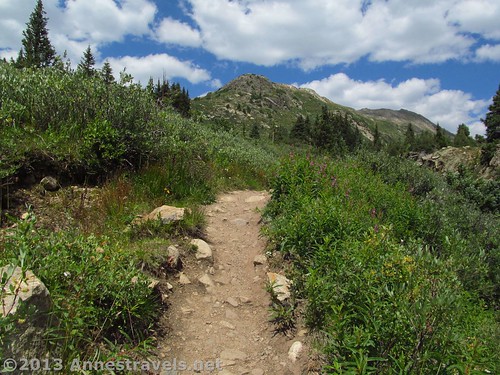
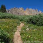
The trail begins in the middle of the parking area just to the left of the stream, known as the Roaring Fork River. From the beginning it’s a fairly steep, rocky trail, with plenty of bushes growing on either side. However, after the first real ascent, the trail flattens out some for the first 0.1 mile (0.1 km) or so. At this point, the trail splits. Go left here, following the sign for Linkins Lake instead of the Lost Man Trail. (The Lost Man Trail also looks gorgeous – it’s not my list of things to do next time we’re in the area). After the trail split, the Linkins Lake Trail begins to climb in earnest, switchbacking upward along the side of the valley, fairly quickly entering the Hunter-Fryingpan Wilderness Area of the White River National Forest.
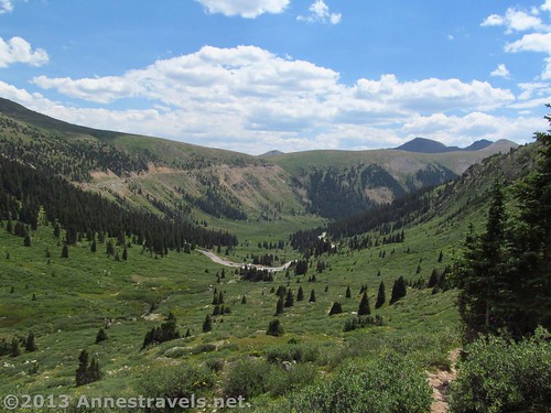
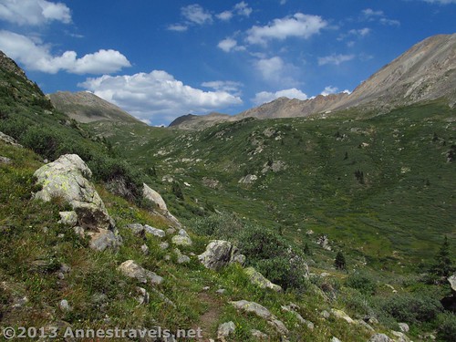
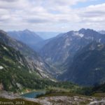
Looking back toward Independence Pass
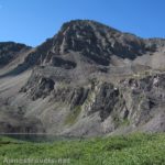
The nice thing about this part of the trail is the views – it seemed like every time I turned around, the views of the valley got better. Below me, I could see the Lost Man Trail, as well as the Roaring Fork River. Cliffs and mountains rise all around the valley, giving it an almost Cascade Range appearance. Across the valley is Twining Peak; on this side of the valley are Geissler Mountain West and Geissler Mountain East. Independence Lake is out of sight over the ridge – this is where the Roaring Fork River begins. Independence Pass is also visible back toward the way you came, along with the peaks surrounding it.
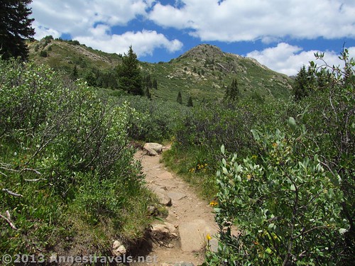
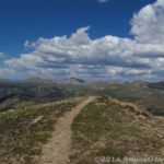
Keep climbing, looking down and up now and then to enjoy the view. You’re well over 11,000 feet (3,000 m) above sea level here, so don’t be surprised if you find yourself out of breath. Suddenly, after climbing for what seems like a very long time, the trail will flatten out and – there before you – is Linkins Lake! You’ve now hiked about 0.7 miles (1.1 km) from the parking area.
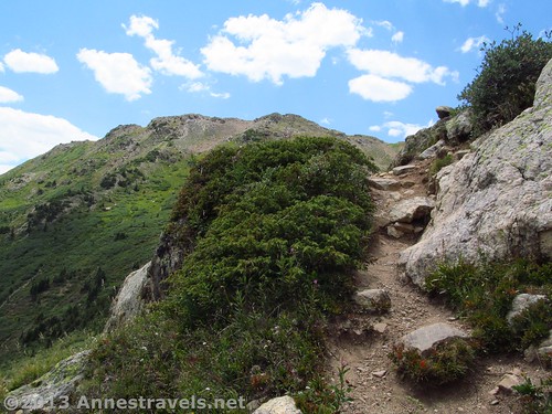
The beginning of the Linkins Lake Trail
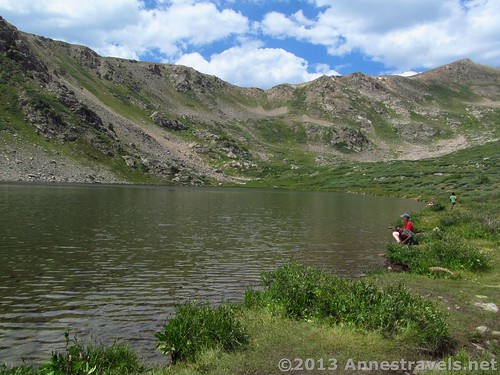
Enjoy the lake for a bit before returning to your vehicle. We waded a bit; the water doesn’t get deep too fast so we could just take off our socks and shoes since we were all in shorts. Across the lake, someone was swimming – I would have thought it was too cold for that, but, hey, he looked like he was having fun. Some clouds blew in (it was afternoon, after all!), but they weren’t stormy, so we didn’t have to make a hasty exit. If you go around the lake (either direction) you can probably find some rocks to sit on; there really aren’t any rocks near the outlet, which is near where the trail brings you to the lake.
Return by the way you came. This isn’t an all-day hike by any means; I think we did it (including a long stay at Linkins Lake) in less than 3 hours. However, if you’re looking for a pretty little hike that might not have as many crowds as Independence Pass…this may be perfect for you!
Views up the valley toward Independence Lake (well over the ridge seen here)
Round Trip Trail Length: 1.4 miles (2.25 km)
Net Elevation Gain/Loss: 460 ft. (140 m) from trailhead (11,530 ft.; 3,514 m) to Linkins Lake (11,988 ft.; 3,654 m)
Starting Elevation (Parking Lot): 11,417 ft. (3,480 m)
Ending Elevation (Linkins Lake): 11,988 ft. (3,654 m)
Facilities: None
Fees: None
Trail 
Road
Signs
Scenery
Would I go 100 miles out of my way for this?
Overall Rating:
Key GPS Coordinates for Linkins Lake
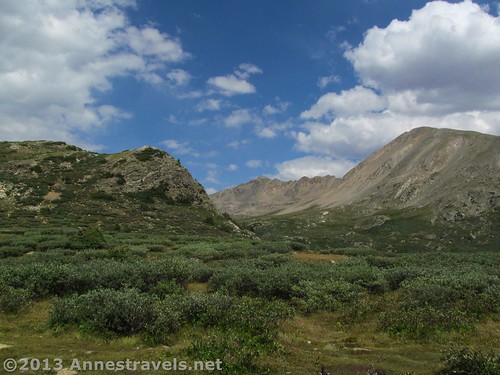
Nearing the top of the Linkins Lake Trail
Linkins Lake Parking (more parking across the road): 39.12462N / 106.58162W (11,417ft.; 3,480 m)
Linkins Lake Trailhead: 39.12473N / 106.58186W (11,530ft.; 3,514 m)
Linkins Lake Trail/Lost Man Trail Junction: 39.12626N / 106.58330W (11,639ft.; 3,547 m)
Linkins Lake: 39.12798N / 106.58732W (11,988ft.; 3,654 m)
The gpx file for Linkins Lake can be downloaded – please note that this and the GPS Coordinates are for reference only and should not be used as a sole resource when hiking this trail.
Download GPS File File size: 49.7 KB Downloaded 165 times
(Note: I do my best to ensure that all downloads, the webpage, etc. are virus-free and accurate; however, I cannot be held responsible for any damage that might result, including but not limited to loss of data, damages to hardware, harm to users, from use of files, information, etc. from this website. Thanks!)
Getting to Linkins Lake
View from Linkins Lake
From Leadville, CO, drive south on US-24 E for about 14 miles (22 km) to CO-82 W. Turn right toward the town of Twin Lakes. Drive 25.5 miles (41 km) on CO-82 W. After crossing Independence Pass, descend the first switchback. At the end of this switchback is a parking area next to a culvert that goes under the road. Park here; the trail begins near the culvert.
From Aspen, CO, drive about 17 miles (27 km) east on CO-82 E. The Linkins Lake Trailhead is 4 miles (6.4 km) east of the Lost Man Campground and Trailhead.
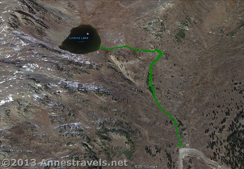
Linkins Lake Trail Map
This Week’s Featured Product!
A guide to Colorado’s mountain passes that can be accessed by 4×4 vehicles or on foot – no paved roads to the passes in this book. For those who love views or adventure, this is a good guide.

Excellent weblog here! Additionally your web site loads up fast! What host are you using? Can I am getting your affiliate link to your host? I want my website loaded up as quickly as yours lol
Hi chwilowki,
I use BlueHost; scroll up to the bottom of the post and click on the ad to use my affiliate id.
Thanks!
Anne