
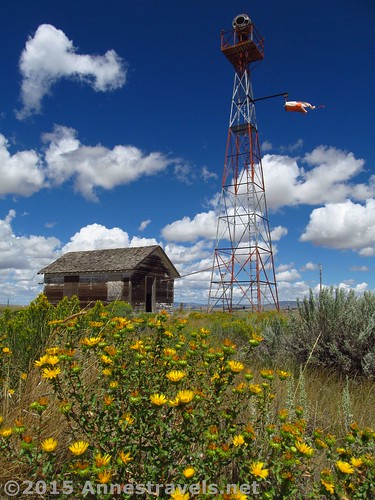
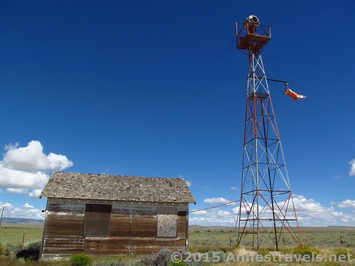
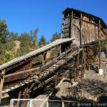
The beacon tower and generator shed at the Medicine Bow Aircraft Arrow (out of sight)
A couple weeks ago, I mentioned I’d soon post about a much more exciting aircraft arrow than the one on Pilot Hill. Well, I got sort of carried away with fall posts, but here’s the rest of the story – the Medicine Bow Aircraft Arrow, which is exciting because it still has the beacon tower, beacon, and generation station! Oh, and did I mention it was simply terrifically photogenic?
So what were the aircraft arrows used for?
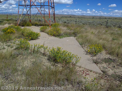
The concrete arrow
In the early days of Aviation, there wasn’t radar, radios were finicky, aerial photography didn’t exist, and pilots had little choice but to know landmarks as best as they could from the sky. Thus, when transcontinental flight began to “take off” in the 1920s, it became necessary for some kind of landmark to be put into place to allow pilots to know where they were at any given moment, or at least which way to turn to stay on course. The solution was to make a string of concrete arrows, visible from the sky, with beacon lights on them at night.
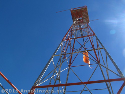
Looking up at the beacon tower
Although many of these arrows have been destroyed or crumbled into nothing, some still exist in many states across the US (this is a great site about finding various arrows). I had the opportunity recently of visiting two of the arrows in Wyoming, both fairly close to I-80. I talked about the first arrow (#37 Pilot Hill) in a previous post, and today I’ll be focusing on the second arrow (#32 Medicine Bow). This arrow was on the San Francisco, CA – Chicago, IL route, established in the 1920s.
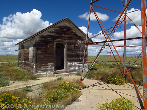
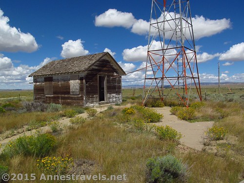
The generator shed
The second facility (#32 Medicine Bow – aka the Medicine Bow Arrow) was in much better condition than the one on Pilot Hill. (Interestingly, though, the area was much more overgrown than the pictures I’ve seen elsewhere.) The beacon tower – and beacon – and generator building are still very much intact, although the interior of the generator building has been vandalized. Having the tower – let alone the beacon – is very rare, making this site all the more exciting! (I read in a British newspaper that the beacon towers were scrapped during WWII for the war effort…) The arrow itself is also in good shape, and points generally S-SE.
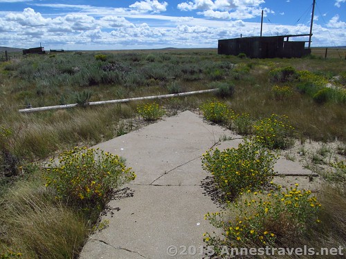
The arrow is in good shape, if slightly cracked, and points S-SE
The route to the arrow is more or less car-friendly to get to if on a detour off of I-80. It’s on the dirt road leading to the Medicine Bow Regional Airport (not that I saw any planes), but it’s also a little more questionable whether or not you (or I) really belong there. A gate closed off the road, but it wasn’t locked, and there weren’t any “no trespassing” signs, so I suppose it’s ok. At any rate, we walked around a bit, and didn’t touch anything.
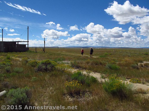
Walking around the Medicine Bow Airport
The arrow is similar to Pilot Hill (if in slightly better condition), but the beacon tower and generator building are more interesting. It’s also very photogenic, especially on a morning in early August, with the wildflowers blooming and puffy white clouds in the clear blue sky.
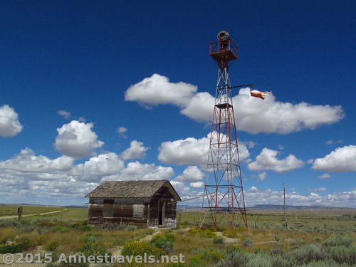
The beacon tower and generator shed
On the way back, we stopped at the Medicine Bow Museum, which was really quite enjoyable (post coming soon!)
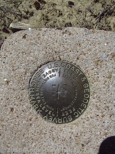
We even found a geological survey marker at the airport!
Required walking distance: None, although if you really want to see the arrow, you’ll need to get out of your car and walk maybe 50 feet RT.
Facilities: None; you can get water, information, restrooms, etc. at the Medicine Bow Museum.
Notes: Don’t vandalize – keep the area clean and open to the public. And don’t trespass – if there are signs up, throw your hands in the air, bemoan your fate, and drive away. I had picked up a brochure at the Lincoln Rest Stop (high point on I-80) about the Lincoln Highway. As this section of US-287 was once part of the Lincoln Highway, it really made the drive more interesting. For example, you’ll pass a bluff where tons of dinosaur fossils were found. I forget the exact percentage, but if you’ve seen dinosaur fossils in a major museum, you’ve almost certainly seen something that was found in that bluff.
Fees: None.
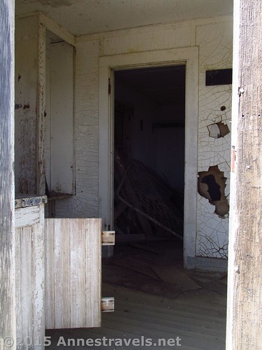
Sadly, the interior of the generator shed has been vandalized
Walking difficulty 
Road
Signs
Scenery
Would I go 100 miles out of my way for this?
Overall Rating:
An early look while approaching the arrow
Key GPS Coordinates for the Medicine Bow Arrow
Parking: 41.88696N / -106.19018W (41° 53′ 13.056″ / -106° 11′ 24.6474″) (6,621ft.)
Arrow: 41.88707N / -106.18989W (41° 53′ 13.452″ / -106° 11′ 23.604″) (6,629ft.)
Looking up at the beacon tower
Getting to the Medicine Bow Arrow
In Laramie, WY, take Exit 313 to US-287 / 3rd St; turn right on US-287 for 57.5 miles. Turn left onto Medicine Bow McFadden Road for 0.4 miles; turn left again on the road to the airport and the arrow. To return to I-80, go back to US-287; turn left. After 36.2 miles, turn right onto the ramp for I-80 W (at Exit 235 – if coming from the west, take Exit 235, turn north on US-287, and follow the good paved road 36.2 miles. In the town of Medicine Bow, across the street from the Virginian Hotel, turn right onto Medicine Bow McFadden Road for 0.4 miles; turn left onto the road to the airport and the arrow). After leaving US-287, the roads are dirt; however, they are in good condition (if you can live with a little washboard) and should be accessible by most vehicles.
Zoom map out to browse nearby hikes & places of interest
The arrow and generator shed
This Week’s Featured Product!
Love the dirt roads of Wyoming? This book covers 145 different routes, some for 4×4 enthusiasts, and others suitable for those with low clearance, through beautiful landscapes, historical sites, and more.

Pingback: Blog Sneak Peak: The Wyoming You Never Knew
Pingback: Medicine Bow Museum: Quite the Collection! - Anne's Travels
Pingback: 10 of the Best Free Historical Sites in America - Anne's Travels