
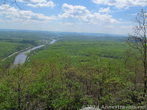
View from the top of Mount Minsi
This week we’ve been visiting family in New Jersey. However, no one in our family likes to sit around doing nothing (which I guess is why we take cross-country trips, right?) so we’ve been visiting various destinations across the state while we’re here. One day, we decided to do Mount Minsi (which is just across the Delaware River into Pennsylvania), a peak we always pass as we drive toward the relatives’ house but have never climbed. It was a perfectly lovely hike for a semi-warm day in late May, peaceful on a weekday, and the views definitely rivaled those from Mount Tammany across the river. At only 5.5 miles (8.8 km) RT, it also gave us time to visit family as well as hike a mountain.
Quick Stats
One of the less-impressive “rhododendron tunnels” along the trail
We parked at the end of the Mount Minsi Fire Road. You could also park at Resort Point and access the Appalachian Trail (AT) from there, but we had our eye on hiking down the AT to the bridge that spans the Delaware River (the I-80 bridge) and walking across via the pedestrian lane, and this is easier from the former parking area. (We did actually walk down to the bridge, but that’s a story for another post!) The trail begins to descend fairly quickly on the wide path (it is an old road, after all) arriving quite quickly at Lake Lenapi. I’ve heard that the lake is often low, but after the recent rains it was about ready to run over its rim! A stream runs under the path and falls in a waterfall.
From here, the trail climbs quite steadily. After 0.3 miles (0.5 km), the fire road and the Appalachian Trail – which follows the fire road until this point – split in a fairly impressive Y (i.e., you can’t miss it). Either will take you up to the top, but we opted to take the left fork – the AT – on the way up and take the fire road on the way down. This turned out to be a very good way to do it, so I’d recommend it unless you’re willing to sacrifice views for the sake of a wider, smoother trail (the fire road is a nicer trail, but the AT has all the views – and believe me, those views are worth seeing).
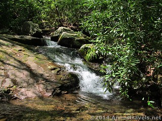
The waterfall on Eureka Creek
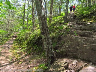
The trail mostly climbed, dipping a few times to cross creeks (Eureka Creek has a lovely little waterfall right next to the “trail”). Even after the recent rains, the creeks were easily crossed on stepping stones. We noted that there are many social trails that go off of the main trail early on in the hike; the higher we went, the less there were. We passed Council Rock at mile 0.5, but as there isn’t a view, we just passed it by. There are some peek-a-boo views, especially of I-80 and the Delaware River. Then, at 1.2 miles (1.9 km), we came to a place where the AT turned up a rock staircase (which in AT terms means you have to scramble up some rocks that are just short enough to be considered stairs instead of a boulder pile) and a very well-traveled social trail continues straight. We’d been warned about this junction, but since half of us missed it, and the other half decided it was a good idea to follow the social trail, we all continued straight for 0.1 miles (0.2 km) to the viewpoint at the end of the social trail.
The tricky trail junction – left to the viewpoint, right for the AT
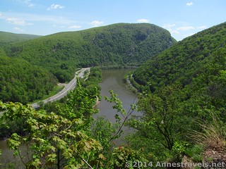
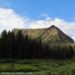
And oh, what a view! It would be worth hiking up Mount Minsi just for this viewpoint, even though there are others that are also extremely nice (in Eastern US terms). We were standing on the edge of a cliff, with the Delaware River right below us, with I-80 winding along by the river, and Mount Tammany beyond. We could also see far into Pennsylvania and quite a ways into New Jersey. Since you’re right on the edge of a cliff, and there is nothing to keep you away from the edge, you’ll want to exercise caution and stay up on the rocks of the viewpoint (the rocks remind me a bit of Artist Point in Yosemite, but the view is vastly different!)
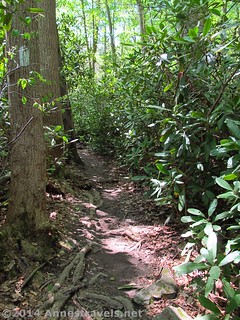
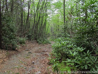
From here on out, the trail is rockier and steeper. The steepness is somewhat made up for by several “rhododendron tunnels” where the trail passes through forests of rhododendron bushes that surround the trail to the point of closing in over your head. They really are nice, and I would love to see them when they’re in bloom.
The view from the first good viewpoint toward the Delaware Water Gap
Only 0.6 miles (1 km) later, the trail crosses the fire road. We stopped for a snack here (thanks Aunt S!), as some of the little ones were lagging. We then opted to follow the AT (diagonally across the road), but you could follow the road; it’s no longer and is certainly easier walking. After only 0.1 miles (0.2 km), the trail comes out to the fire road; turn right and follow the road (or “road” in some places) to the top of Mount Minsi, 0.4 miles (0.6 km) later (5.5 miles (8.8 km) from the trailhead). Along the way, the trail comes to another break in the trees, this time right along the main trail. This time the view is a bit more restricted, but it’s still very nice. Mount Tammany stars, and since you’re much closer to the top here, it’s more spectacular (especially the cliffs).
At top of the mountain are the remains of a fire tower, an old building, and, slightly further down the trail, a stack of logs with a sign on it that says, “Mount Minsi”. There is absolutely no view here. None. A little disappointed, we took some pictures of the sign. But one of our group was walking ahead, and less than 0.1 miles (0.2 km) from the sign, he’d discovered a side trail that led to a place where the trees had been cleared out to reveal a view.
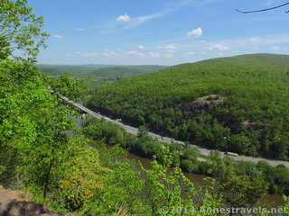
View from the first good viewpoint, looking toward the I-80 bridge
I followed him to the viewpoint, and I thought the view really was nice. The Water Gap isn’t visible, like the other views; this viewpoint looks out over the Poconos and Kittatinnies (the Pocono Mountains in New Jersey). The Delaware River is very visible, and I like the multi-arched train bridge (no longer in use) that stretches across the river. The one ugly thing is some smokestacks, but I guess we have to take the ugly with the beautiful!
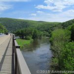
After lunch at the viewpoint, we headed back down the trail. We retraced our steps to the place where we’d crossed the road earlier, then turned down the fire road instead of following the AT back down to the first good view. The road was a very pleasant walk between rhododendrons and beach trees. The road was once gravel, but it’s fairly rocky now. It’s still wide, though, so you can choose which rocks you want to step on and which you’d rather avoid. There aren’t any views to speak off (not even peek-a-boo), but the peacefulness of the forest is nice (especially on the early part of the AT, I-80 can be heard through the forest along with birdsong and forest noises).
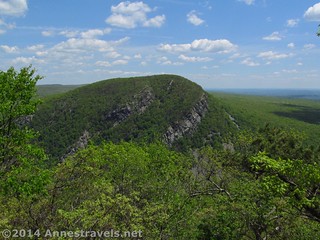
Mount Tammany from the second good viewpoint
The closer we got to the parking area, the more social trails going off of the trail we found. We didn’t follow any of them, though I guess a lake must be down one or more of the ones on the left. The only confusing junction is at 4.8 miles (7.7 km), when a side road (also gravel) joins the fire road; continue straight rather than turning left. Also remember to go straight (rather than right) when the AT rejoins the fire road at 5.1 miles (8.2 km).
We returned to the parking area at 5.5 miles (8.8 km), a little tired, but very happy…the hike was definitely worth it!
Round Trip Trail Length: 5.5 miles (8.8 km)
Starting Elevation: 513 ft. (156 m)
Highest Elevation: 1,477 ft. (450 m)
Net Elevation Gain: 964 ft. (294 m)
Facilities: None
Fees: None
Trail 
Road
Signs
Scenery
Would I go 100 miles out of my way for this?
Overall Rating:
Key GPS Coordinates for Mount Minsi
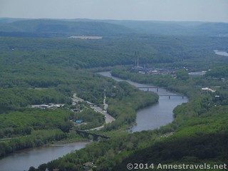
Zoomed in on the old trail bridge and smokestacks from the top of Mount Minsi
Parking: 40.97982N / -075.14203W (40° 58′ 47.3514″ / -75° 8′ 31.308″) (520 ft.; 158 m)
Beginning: 40.97972N / -075.14151W (40° 58′ 46.992″ / -75° 8′ 29.4354″) (513 ft.; 156 m)
At leaves fire road: 40.97600N / -075.13972W (40° 58′ 33.5994″ / -75° 8′ 22.9914″) (592 ft.; 180 m)
Council Rock: 40.97403N / -075.13827W (40° 58′ 26.5074″ / -75° 8′ 17.772″) (540 ft.; 165 m)
First viewpoint junction (left to viewpoint; AT goes right): 40.96859N / -075.13516W (40° 58′ 6.9234″ / -75° 8′ 6.5754″) (796 ft.; 242 m)
Viewpoint #1: 40.96857N / -075.13483W (40° 58′ 6.8514″ / -75° 8′ 5.3874″) (796 ft.; 242 m)
Cross fire road: 40.96397N / -075.12915W (40° 57′ 50.292″ / -75° 7′ 44.9394″) (1,311 ft.; 399 m)
Walking down the fire road
Cross fire road again: 40.96353N / -075.12831W (40° 57′ 48.7074″ / -75° 7′ 41.9154″) (1,316 ft.; 4.1 m)
View #2 (Mount Tammany View): 40.96271N / -075.12675W (40° 57′ 45.756″ / -75° 7′ 36.3″) (1,367 ft.; 416 m)
Summit: 40.95964N / -075.12856W (40° 57′ 34.704″ / -75° 7′ 42.8154″) (1,477 ft.; 450 m)
Summit view trail junction: 40.95906N / -075.12885W (40° 57′ 32.616″ / -75° 7′ 43.8594″) (1,471 ft.; 448 m)
Summit view: 40.95889N / -075.12862W (40° 57′ 32.0034″ / -75° 7′ 43.0314″) (1,465 ft.; 446 m)
Go straight, not left on another gravel road: 40.97237N / -075.14262W (40° 58′ 20.5314″ / -75° 8′ 33.4314″) (665 ft.; 202 m)
The gpx file for Linkins Lake can be downloaded – please note that this and the GPS Coordinates are for reference only and should not be used as a sole resource when hiking this trail.
Download File size: 114.8 KB Downloaded 124 times
(Note: I do my best to ensure that all downloads, the webpage, etc. are virus-free and accurate; however, I cannot be held responsible for any damage that might result, including but not limited to loss of data, damages to hardware, harm to users, from use of files, information, etc. from this website. Thanks!)
Getting to Mount Minsi
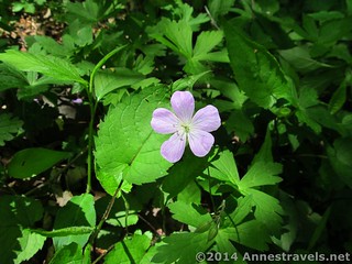
Wildflower along the trail
From I-80, take Exit 310 onto Broad Street. Drive 0.4 miles to a T intersection; turn left onto Main Street / PA-611 S. After 0.3 miles, turn right onto Mountain Road. After only 0.1 miles, take a slight left onto Lake Road, following the Appalachian Trail signs and white blazes. Drive 0.1 miles to the end of the road, which is the trailhead.
Alternatively, from Portland, PA, drive 5.5 miles north on PA-611 N. Turn left onto Mountain Road, then take a slight left onto Lake Road after 0.1 miles, following the signs for the Appalachian Trail. Drive 0.1 miles to the end of the road, which is the trailhead.
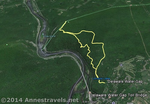
Visual map of the Mount Minsi Loop – trailhead is at the bottom; north is down
Zoom map out to browse nearby hikes & places of interest
This Week’s Featured Product!
The authors of this week’s featured book say they have a “love affair” with the Appalachian Trail. Due to this, they’ve attempted to take the AT and tell you which sections are worth hiking, what you’ll see along the way, and other useful information. Filled with detail, users love this comprehensive book.
[forecast location=”Delaware Water Gap, PA” caption=”Weather for Mount Minsi” measurement=’F’ todaylabel=”Today” datelabel=”date(‘D M d’)” highlow=’%%high%%°/%%low%%°’ numdays=”5″ iconset=”Default”]


Pingback: Anne's Travels » Hiking the Bridge to the NJ/PA State Line on the AT