

A view along the trail
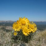
Ah…Top of the world views! I recently found a new place that offers them! A place I’ve never been before and—because of the road—I may never visit again. However, the views were spectacular: snowcapped peaks, mountain lakes, snowfields, rocks, and even alpine flowers. And you’re on the tundra with nothing (sometimes not even a trail) to get in the way of your views. I took a little hike along an old mining road, and ended up on top of a little hill with sweeping views in every direction. There was even a windblock which made the hilltop even more enjoyable. This hike can be lengthened to see more mountain lakes, or even to climb Mount Rearguard, a massive nearby mountain. I highly recommend the hike to people with high clearance vehicles who love sweeping views and top-of-the-world experiences.
Key GPS Coordinates for the Little Mountain Near Mount Rearguard:
Mount Rearguard Parking Area: 45.038002N / -109.452125W (45N 2′ 16.0866″ / -109W 27′ 7.6494″)
Little Mountain (approximate): 45.025882N / -109.489644W (45N 1′ 33.1752″ / -109W 29′ 22.7178″)
Getting to the Mount Rearguard Parking Area:
From the east, drive between 11 and 12 miles (17 to 19 km) from Red Lodge (depending on where you’re measuring from). The road up to the parking area is on your right and well-marked for the several National Forest Campgrounds that are also on the road. This turn is between the sign for “National Forest Campgrounds” and the “Adopt a Highway” sign. If you’re coming from the west (Beartooth Pass), this road is about 3 miles (4.8 km) from the last switchback, on your left. The road will be paved for a short while, then cross a bridge. A short time later, the road will fork; go straight (right). This road is marked 2004. Here it begins as a bone-jarring assent, and gets only marginally better.

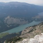
Mount Rearguard peaks up over the tundra
Most of the way up, the road is very narrow (barely one-car wide) and very, very rough. It’s passible by 2-wheel-drive vehicles (I did it!), but you wouldn’t want to try it without high clearance. In fact, unless you like rough roads, you might want to think twice about driving the road at all—I’m not sure I’d do it again. It’s also not passible by vehicles with trailers. The road winds upwards, always upwards, usually quite steeply. I’m not really trying to get you to not drive the road, but I also don’t want you to think this is a stroll in the park. After 6.5 miles (10.5 km), you will suddenly break through the tree line and enter a small parking area. We opted to camp just below the parking area in a grove of low-lying trees. It was very nice and peaceful there. Park your vehicle, and then head over towards the sign board on the left side of the parking lot. (Some people opt to spend the night in the parking area and then set out early the next day By the way, a party camped next to us, and they seemed very surprised that there was anyone else staying here, so it must be deserted most of the time.)

Walking along the old mining road
From the parking area, the trail is easy to follow over the tundra. Before long, you will see Mt. Rearguard appear over the hill. Continue to follow the trail (or the old mining road; either works) to the top of the hill and as it continues across the ridge. It may look easier to get to Mt. Rearguard by scrambling down the side of the ridge and then crossing the valley, but this isn’t the case. The sides of the ridge are very steep. So, keep following the mining road. You’ll go uphill for a while, then come to a pretty view near a post. It looks like there was a sign on this post at one time, but there’s nothing on it now. After another short uphill section, the road will flatten out (i.e., you might even be going a bit downhill!). This is a great part of the hike because you have views all around you and you feel as if you’re on the top of the world. You can still see Mount Rearguard looming up across the valley from you—I think they named it “Rearguard” because you can see it from just about everywhere.

Walking along the tundra
After about 2 miles (3.2 km) from the trailhead, you’ll come to another parking area. You’re not actually allowed to drive to it; you can just see where a parking area used to be (note the rocks in a semi-square around an area of trampled tundra). From here, the trail really begins to climb. Several trails lead up the hill from the second parking area; you want the one that heads up towards an outcropping of rock sort of straight ahead and to your left. This outcropping isn’t huge, but it’s very noticeable. Climb up the trail as it steeply ascends the hill. The views get better as you climb, so when you stop to catch your breath, be sure to look around you. Remember, you’re between 10,000 and 11,000 feet here, so the air is quite a bit thinner than in the valley. I made the mistake of making this the first hike on a trip—I live at 400 feet above sea level, so this was quite the change in elevation for me!

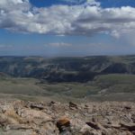
Looking back towards the trailhead from the hilltop
Eventually, you’ll come to a place where the path flattens out and heads to the right over the tundra. Instead of following the road, go left up the side of the mountain towards the top of the hill. I highly recommend this as a destination, or as a detour if you want to climb Mount Rearguard (which I’ll talk about in my next post). The climb to the top is steep, but very doable. One of the nicest things about the top is that there’s a windbreak. So, you can get out of the unrelenting wind if it’s chilly. (We were very thankful for this!) From the top of this peak, the view is extremely pretty. There are cliffs which, at least when I hiked it in mid-July, where flecked with snow, the area around the Beartooth Highway, and of course Mount Rearguard. It’s breathtaking. We ate lunch here, and then headed over towards Mount Rearguard. I’ll talk about the second stage of the journey in the next post.

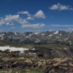
One of the views from the hilltop, towards the Beartooth Mountains
The bottom line: This is a beautiful area, and a great day hike. Even if you don’t want to go all the way to Mount Rearguard, this hike is one that everyone who loves top-of-the-world experiences will enjoy.
Round Trip Trail Length: About 6 miles (9.6 km) (maybe a little less)
Facilities: None
Fees: None
Trail 
Road
Signs
Scenery
Would I go 100 miles out of my way for this?
Overall Rating:
This Week’s Featured Product!
Looking for even more hikes near the Hellroaring Plateau? Try these!


I located you’re blog via Yahoo and I have to say an Enormous Thank you very much, I believed that the article was very enlightening I’ll revisit to see what additional great information I can recieve here.
Awesome info over again! Thumbs up.
Pingback: Vista Point on the Beartooth Highway
Pingback: Top of the World Views on the Beartooth Highway