

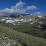
Part of the view from Mount Rearguard
Want a little adventure? A hiking adventure that has little or no trail through top-of-the-world scenery to the top of a craggy peak in the middle of nowhere? If this sounds like fun, than Mount Rearguard may be the hike you’re looking for. At 12,209 feet (3,372 m) above sea level and situated on the Hellroaring Plateau of Montana, the mountain overlooks Beartooth Pass and many mountains in the area, including Spirit Mountain, as well as several lakes. The view from the top is spectacular, but so is the hike to it: you’ll be walking across a grassy plateau most of the way, first following an old mining road and then trekking cross-country across the grass and rocks (not too difficult going and you can’t get too badly lost if you have a sense of direction or a compass and topo map). All around you are mountain peaks, pretty lakes, and, at some times of the year, flowers carpeting the ground. And you get that wonderful feeling that you’re on the top of the world. Sound exciting? Let’s go!
Key GPS Coordinates for Mount Rearguard:
Mount Rearguard Parking Area: 45.038002N / -109.452125W (45N 2′ 16.0866″ / -109W 27′ 7.6494″)
Where you start the ascent (approximate): 45.039677N / -109.527512W (45N 2′ 22.8366″ / -109W 31′ 39.0432″)
Top of Mount Rearguard: 45.048278N / -109.526276W (45N 2′ 53.8008″ / -109W 31′ 34.593″)

Hiking along the ridge toward Mount Rearguard
Getting to Mount Rearguard:
From the east, drive between 11 and 12 miles (17 to 19 km) from Red Lodge (depending on where you’re measuring from). The road up to the parking area is on your right and well-marked for the several National Forest Campgrounds that are also on the road. The road is between the sign for “National Forest Campgrounds” and the “Adopt a Highway” sign. If you’re coming from the west (Beartooth Pass), this road is about 3 miles (4.8 km) from the last switchback, on your left. The road will be paved for a short while, then cross a bridge. A short time later, the road will fork; go straight (right). This road is marked 2004. Here it begins as a bone-jarring assent, and gets only marginally better.

Another view from the top
Most of the way up, the road is very narrow (barely one-car wide) and very, very rough. It’s passible by 2-wheel-drive vehicles (I did it!), but you wouldn’t want to try it without high clearance. In fact, unless you like rough roads, you might want to think twice about driving the road at all—I’m not sure I’d do it again. It’s also not passible by vehicles with trailers. The road winds upwards, always upwards, usually quite steeply. I’m not really trying to get you to not drive the road, but I also don’t want you to think this is a stroll in the park. After 6.5 miles (10.5 km), you will suddenly break through the tree line and enter a small parking area. We opted to camp just below the parking area in a grove of low-lying trees. It was very nice and peaceful there. Park your vehicle, and then head over towards the sign board on the left side of the parking lot. (Some people opt to spend the night in the parking area and then set out early the next day. Because it’s a 12-mile (19 km) out-and-back hike up Mount Rearguard, it’s best to get a very early start so you can be down before the afternoon thunderstorms roll in).

Map of my route up Mount Rearguard
In my previous post, I talked about how to get to a little mountain with a great view. From here, you can keep walking across the tundra—if you’re up to some off-trail hiking, I highly recommend it because of the views at the base of Mount Rearguard. Actually, you can also climb Mount Rearguard from this approach; I did it. However, that makes for a 12+ mile (19+ km) hike, with the last part being a rock scramble. So you’d better be in really, really good shape before you attempt Mount Rearguard as a day hike. (Realize, though, that I did it as the first hike on a trip…a very bad idea. Those of us who had been biking and hiking all over the place for weeks before we left home made it to the top of the mountain, but half the group didn’t make it up…so make sure you’re well and in good shape before you attempt it.) The diagram shows the general route I took up the mountain.

Overlooking Moon Lake
From the hilltop, head north along the “bench” of tundra. You’ll go down a bit, then begin to climb again, flattening out as you walk along the side of the hill. This area looks quite flat and smooth from the hilltop, but it actually has many smaller rocks all over it. This doesn’t make for difficult going, but do watch your step. Keep walking along the “bench” as it approaches Mount Rearguard. As you get closer to the mountain, the ground gets rockier and rockier. Also watch out for the wet areas; there are many small springs in this area. After an especially rocky section (you may actually have to scramble a little), you will come to Mount Rearguard proper, an imposing hill suddenly rises straight up (or so it looks) just on your right. If you’re looking for a great view, head over to the left across (or around) the large pile of rocks. On the other side, you will find an incredible view: below you is a pristine mountain lake, rising into a sheer rock wall. Amazing! This is Moon Lake, quite the destination unto itself if you approach from a different angle (up the valley you’re looking down into).

The overlook above Sliderock Lake
If you’re doing a day hike, this is a great place to turn around and make it a 10 mile (16 km) or so round trip hike. But, of course, we couldn’t leave well enough alone, and I was determined to get to the top of the mountain. If you’re in the same boat as me, and there are no thunderstorms rolling in, start up the steep hill to the right of the “bench” you just crossed. This is a very steep ascent; you may find yourself using your hands occasionally. There are a number of small trails in this area, but don’t be misled. There is no trail to the top of Mount Rearguard. You can also follow the streams that run down the mountain. Any way you decide to go, you’ll be climbing over small rocks and through grass, very similar to what was on the “bench” except that now you’re climbing a 70 degree angle upwards (ok, maybe it’s not quite that steep).

The top of Mount Rearguard
Keep climbing upward until you come to a flatter section. (Note: in the diagram, it says, “The route goes behind the mountain.” This simply means that the route I took went behind an outcropping in the picture.) If you strayed too far to the north (left), you may miss this section. However, if you find the flatter section, head straight and maybe a little bit right to a lookout over Sliderock Lake. We had a very nice snack here. You can see just about everywhere you’ve walked to get here—except now you’re above it. When you’re done looking, start heading straight up the mountain whatever way seems best to you. We ended up going a bit right and then up. Beyond this point is completely scrambling; there is no trail and you will be climbing up, around, and over small and large boulders. It’s very doable, but it’s not a stroll in the park. Eventually, you’ll be able to see the top, or at least seems to be the top (this may be a false summit; I’m not sure). Scramble up the last of the boulders, and there you are! Congratulations! You did it!

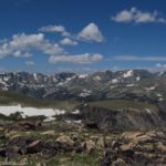
A view from the top
From the top, the views are simply sublime. You can see the cliffs above Moon Lake (these are very impressive), as well as numerous other snowcapped peaks in the Beartooth and Absaroka Ranges. You can also see several summits to Mount Rearguard; I’m not exactly sure which summit is the true one and which are false summits, but I’m pretty sure the one you’re on is the highest one (from looking at maps; it’s impossible to tell from on top of it).

Another view from the top
Return by the way you came. This is a great top-of-the-world hike, if you’re up to it. It would also make a great overnight trip if you backpack.
Round Trip Trail Length: About 12 miles (19 km)
Facilities: None
Fees: None
Trail 
Road
Signs
Scenery
Would I go 100 miles out of my way for this?
Overall Rating:
This Week’s Featured Product!
Find even more hikes in the Beartooth Mountains in this guide. There are more than 60 trails to choose from.


Magnificent web site. Lots of helpful information here. I am sending it to some pals and additionally sharing in delicious. And of course, thanks!
I am amazed by the information in this blog I found it to be more than very fascinating however it also made me reflect. It is hard now a days to find relevant information to ones search, so I am pleased that I found this blog post
Pingback: Vista Point on the Beartooth Highway
Pingback: Top of the World Views on the Beartooth Highway
Pingback: Lookout Mountain - Fabulous Views of Mt. Hood!
Pingback: 12 Trails that Require Hands & Knees, River Crossings, and Other Adventures