
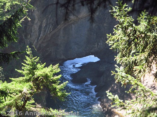
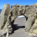
An over-and-under exposed picture of a sea arch or natural bridge we saw on our way to a headland viewpoint near Thunder Rock Cove
Perhaps one of the most scenic areas of the Oregon Coast (which is pretty nice anywhere you end up) is the Samuel H. Boardman State Scenic Corridor, just north of Brookings, and about 10 miles north of the California boarder. I recently traveled the length of US-101 through Oregon (all the way from California to Astoria, which is nearly in Washington), and this was definitely one of the gems. There are tons of sea stacks, beaches, headlands, sea arches, and so much more. It’s actually more scenic (to me at least) than the more northerly sand beaches with their occasional massive sea stack. And one of the good things is that you can explore the corridor by car or on foot, so you really can tailor your trek to your fancies!
Quick Stats
We were sort of low on time (we’d done a few trails in Redwood National Park in the morning), so I thought we’d just see the Natural Bridges, maybe Thunder Rock Cove, and then have dinner at the Arch Rock Picnic Area (which I’ll talk about in another post – it’s worth one of its own!)
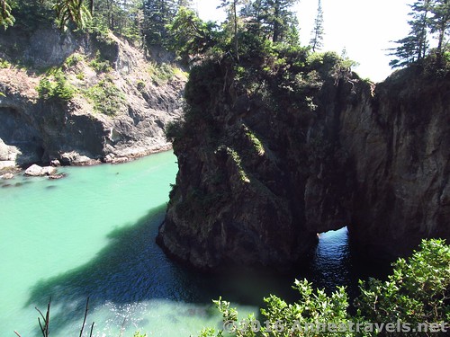
We pulled into the Natural Bridges Overlook parking area (just a gravel pull off along US-101 about mile 346.0). Now, what we should have done to see the natural bridges was to go to the left (south) end of the parking area and follow the Oregan Coast Trail 150ft. to a wooden overlook of the natural bridge. It’s really a great view.
The view from the Natural Bridge Overlook
However, I didn’t know what I was doing, so we went to the north (right) end of the parking area and followed the somewhat dubious-looking Oregon Coast Trail into the rain forest. This ended up being a really great adventure, so I’ll tell you how you can enjoy it, too.
Oh, and I forgot to say: if you love rain forests (or just lush forests in general) you’ll love this trail. There are ferns, mosses, (fairly) tall trees, and more all along the trail.
Coastal views
Follow the trail 0.1 miles to a place where the trail splits, with the Oregon Coast Trail goes right and a social trail goes left, steeply uphill. There aren’t any signs (there just plain aren’t many signs in this park!), but if you like views of sea stacks, headlands, beaches, and/or sea arches, you really should take the social trail left up to the top of the hill and see the view.
Now, if you really like sea arches (like I do), and you aren’t afraid of very treacherous trails (i.e., steep and slippery), the social trail continues another 0.1 miles to a place where you can see about 7 sea arches, one of them acting as the entrance to the nearly inaccessible cove below you. (Always keep heading south, downhill; don’t bother following the social trails that go north around the headland – there are more views of sea arches, etc., but that’s not where we’re headed today). I didn’t go all the way down the trail (too steep and treacherous too near the edge for me) but the view was fabulous!
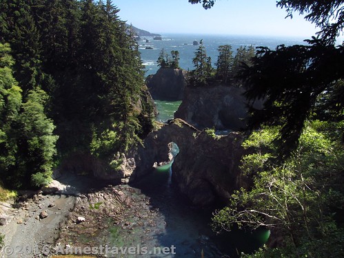
The view from where I saw 7 sea arches. Not sure if they were all arches or not, but the view took my breath away!
Just be super careful near those sheer drops down to the beach!
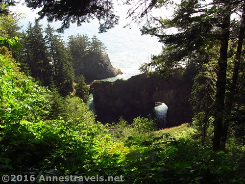
Continuing along the Oregon Coast Trail, come out in the parking area for Thunder Rock Cove at mile 0.4. You could just drive or walk along the road – it would be faster – but the rainforest is nice. You also get a view toward a natural bridge at mile 0.38.
The view is a bit through-the-trees
In the Thunder Rock Cove Parking Area, cross the parking lot and continue past the sign about Thunder Rock Cove on the Oregon Coast Trail.
After another 0.1 miles, come to a sign, marking the beach & falls or the loop trail. (What, a sign? You must be kidding!) I think you can go either way, but you should probably go left, which is what I did.
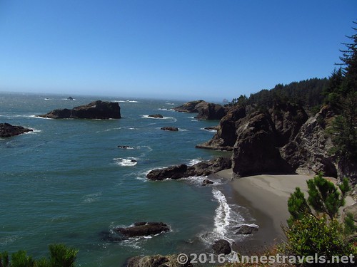
Views of a cove along the way
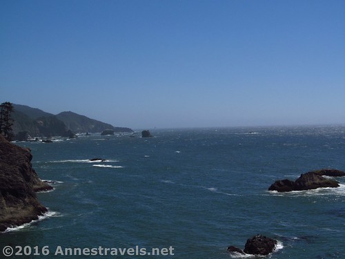
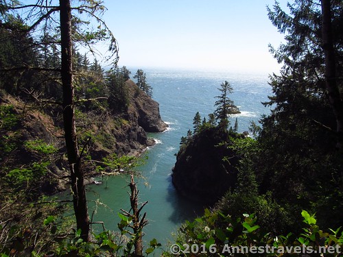
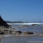
After 0.2 more miles walking through the forest, come to another social trail leading off out on a headland. Follow this trail 0.1 miles to a simply glorious view in both directions, up and down the coast – it’s worth the hike to see this! There are sea arches, sea stacks, headlands, beaches, and the oh-so-pretty ocean.
Views north from the headland viewpoint
Enjoy the view for a bit, then return the way you came. We walked back along the road between the Thunder Rock Cove and Natural Bridges pullouts – and found that the road was about a tenth of a mile shorter!
If you wanted to extend the hike, I wouldn’t necessarily recommend going beyond the natural bridges overlook, but continuing along the trail beyond the Thunder Rock Cove area there are more overlooks and a trail down to the beach. Most of the Oregon Coast Trail is in the trees, but there are always those social trails to find Adventure and Views…
Another natural bridge (can you spot it, sort of to the left?)
Round Trip Trail Length: To the Natural Bridges Overlook: 352ft.; To the social overlook of 7 sea arches: 0.5, To the overlook from Thunder Rock Cove Pullout: 0.8 (starting at the pullout) to 1.3 (starting from the Natural Bridges Pullout).
Elevation Change: About 211ft.
Facilities: None, not even restrooms or picnic tables (both are available at the Arch Rock Picnic Area, the Whaleshead Picnic Area, and the Lone Ranch Picnic Area)
Fees: None
Trail Notes: Be extremely careful on the headlands, a simple slip could be fatal. And don’t rely on signs to tell you where to go – I’m not sure the park believes in trail signs, lol.
Trail 
Road
Signs
Scenery
Would I go 100 miles out of my way for this?
Overall Rating:
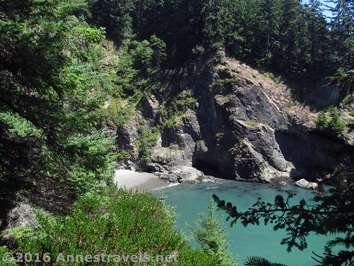
Another view into a cove
Key GPS Coordinates for the Samuel H. Boardman Natural Bridges / Thunder Rock Cove:
Natural Bridges Parking: 42.19003N / -124.36595W (42° 11′ 24.108″ / -124° 21′ 57.4194″) (336ft.)
Beginning (right side of parking area): 42.19004N / -124.36586W (42° 11′ 24.144″ / -124° 21′ 57.0954″) (338ft.) (0.0)
Trail Junction to Viewpoint: 42.19010N / -124.36607W (42° 11′ 24.36″ / -124° 21′ 57.8514″) (348ft.) (0.1)
Natural Bridge Overlook (down the steep trail): 42.18941N / -124.36716W (42° 11′ 21.876″ / -124° 22′ 1.7754″) (320ft.) (0.2)
Viewpoint of a natural bridge: 42.19102N / -124.36734W (42° 11′ 27.672″ / -124° 22′ 2.4234″) (303ft.) (0.38)
Thunder Rock Cove Parking Area: 42.19172N / -124.36694W (42° 11′ 30.1914″ / -124° 22′ 0.9834″) (298ft.) (0.45)
Trail Junction (Loop vs. Beach): 42.19230N / -124.36780W (42° 11′ 32.28″ / -124° 22′ 4.08″) (288ft.) (0.53)
Viewpoint of Another Arch: 42.19150N / -124.36962W (42° 11′ 29.3994″ / -124° 22′ 10.6314″) (145ft.) (0.7)
Thunder Rock Cove Viewpoint: 42.19120N / -124.37018W (42° 11′ 28.32″ / -124° 22′ 12.648″) (127ft.) (0.85)
Trail End: 42.19018N / -124.36607W (42° 11′ 24.6474″ / -124° 21′ 57.8514″) (310ft.) (1.3 total hike)
Key GPS Coordinates for the Samuel H. Boardman Natural Bridges Overlook:
Natural Bridges Parking: 42.19003N / -124.36595W (42° 11′ 24.108″ / -124° 21′ 57.4194″) (336ft.)
Beginning (left side of parking area): 42.18978N / -124.36590W (42° 11′ 23.2074″ / -124° 21′ 57.2394″) (286ft.) (0.0)
Natural bridge Real Viewpoint: 42.18939N / -124.36597W (42° 11′ 21.804″ / -124° 21′ 57.492″) (280ft.) (150ft. from parking lot)
Trail End: 42.18974N / -124.36594W (42° 11′ 23.064″ / -124° 21′ 57.3834″) (288ft.) (350ft. total hike)
The gpx file for my adventures around the Natural Bridges can be downloaded – please note that this and the GPS Coordinates are for reference only and should not be used as a sole resource when hiking this trail.
Trail to Natural Bridge Overlook:
GPX Download File size: 4.6 KB Downloaded 180 times
Social Trail to the overlook of the natural bridges and sea arches:
GPX Download File size: 9.4 KB Downloaded 168 times
Trek from the Natural Bridge Parking Area to Thunder Rock Cove Headland Overlook:
GPX Download File size: 31.1 KB Downloaded 213 times
(Note: I do my best to ensure that all downloads, the webpage, etc. are virus-free and accurate; however, I cannot be held responsible for any damage that might result, including but not limited to loss of data, damages to hardware, harm to users, from use of files, information, etc. from this website. Thanks!)
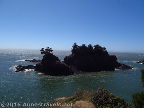
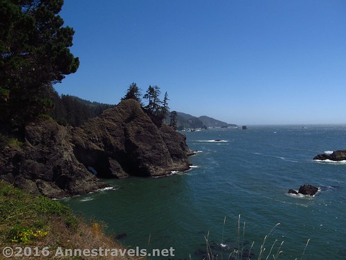
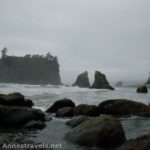
Sea stacks from the headland
Getting to the Samuel H. Boardman Natural Bridges / Thunder Rock Cove:
From Brookings, OR, drive north on US-101 11 miles to the gravel parking area for the Natural Bridges, on left (it’s signed along the road, so just look for the brown signs that say “Natural Bridge Viewpoint”). To get to the Thunder Rock Cove parking area, continue down the road a few hundred feet and follow the sign left into the gravel parking area.
Alternatively, from the north, from Gold Beach drive south on US-101 16 miles to the parking area for the Natural Bridge Viewpoint, on right. The Thunder Rock Cove parking area is a few hundred feet before the Natural Bridge Viewpoint parking area (both parking areas are gravel and right on the road, so they’re hard to miss).
Zoom map out to browse nearby hikes & places of interest
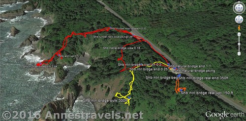
Visual trail map of my adventures around the Natural Bridges and Thunder Rock Cove – Red is my route to the headland viewpoint near Thunder Rock Cove, Yellow is the social trail to the 7 arches viewpoint, and Orange is the trail to the Natural Bridges Overlook.
This Week’s Featured Product!
If you’re looking for more day hikes on the Oregon Coast, this is a great book to check out!
More Related Posts:
 Floras Lake Beach – An Sand Beach with English Cliffs
 Sea Stacks, Sea Arches, & Wilderness on Ruby Beach
 Cape Perpetua: Where the Volcanos Met the Ocean
 Hug Point: Wayside Beach with a Waterfall & Sea Cave
 Exploring the Punchbowl: Above and Within
 Beverly Beach Hike: Lighthouses, Volcanic Rocks, and More
Pingback: Sneak Peak: A Land of Volcanos and Oceans - Anne's Travels
Pingback: Taste and See that the Lord is Good - Anne's Travels