

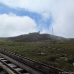
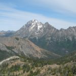
Looking back at Mount Washington from the trail around Mount Monroe
In the last post, I talked about hiking up to Lake of the Clouds via the Ammonoosuc Ravine Trail. We’d planned on hiking from here up Mount Washington. However, we’d made the mistake of sitting still for too long behind the Lake of the Clouds Hut. This was a mistake because even though it was more out of the wind than in front of the hut, it was still quite windy and we all got very cold. So, after seeing the lake and learning that the weather station on top of the mountain said it was experiencing 70 mph winds (later we heard that these had risen to 80mph), we decided that we couldn’t climb Mount Washington in that much snow; we’d just have to come back and do it again some other day. We decided the fastest, safest way down would be to go right, towards Mount Monroe, Mount Franklin, and Mount Eisenhower, and then take the Edwards Path back to the base of the mountains. I’m so glad we did: it was so lovely, especially in the snow, and so much of a top-of-the-world feeling. It was awesome! I’d highly recommend it to anyone who had already climbed Mount Washington, or who had the energy to do the entire loop (if you do Mount Washington, as well, it’s a total of 13 miles; if you skip Mount Washington, it’s only 10 miles).
From the Lake of the Clouds Hut, follow the sign towards Mount Monroe. However, instead of hiking over the top (which I hear is very nice, but which I’ve never hiked), we hiked straight past that trail, and headed over the saddle. The trail will eventually turn right to go along the back of Mount Monroe and then over Mount Franklin. Actually, I think there’s a trail that goes around the back of Mount Franklin as well, but we missed it in the snow. Whatever way you go, it’s beautiful, so it doesn’t really matter; do what suits your tastes! The trail that will take you around the back of Mount Monroe is fairly rocky at this point, but not like the Ammonoosuc Ravine Trail. These rocks are made of shale, and therefore are fairly easy to walk on. Remember to look behind you as you’re walking; for a while you’ll be able to see Mount Washington. Once you get behind Mount Monroe, the trail becomes more dirt and larger rocks, so watch your footing. This part of the trail was a stream when I visited because of the melting snow. Later in the season, it would probably be quite dry.

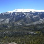
Mount Monroe from the trail around the back side
Continue on around the back side of Mount Monroe. The views from here are really pretty; you’re walking along a kind of tundra above the treeline, with mountains and valleys stretching as far as the eye can see ahead of you and on your left. Supposedly, after a little while, you should connect with a trail between Mount Monroe and Mount Franklin. However, I only saw one trail, so I took it and ended up going over the top of Mount Franklin. It’s not too steep; nothing like the trail I saw ascending Mount Monroe! I actually recommend going over the top of this mountain, because on top of Mount Franklin you feel like you’re on the top of the world. You’re walking on a shallow trail (most of the trail thus far has been worn deep by hikers’ feet) over shale-like rocks with moss and larger rocks all around you, not to mention gorse bushes and views in all directions. It’s so pretty! It made the hike worthwhile, to me, even with all the snow.

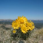
Views from the trail around Mount Monroe
After a while, you will descend towards a saddle that separates Mount Franklin from Mount Eisenhower. This is a fairly steep trail, and it was a stream with many puddles when I hiked it. The trail itself is fairly easy going, however, because it doesn’t have the large rocks in it that some parts of the trail have. The trail goes down and down until it reaches the saddle, passing a couple of signs along the way. At the first sign, you want to follow the Webster Cliff Trail. Actually, you’ll be continuing along the Appalachian Trail, which you’ve been following ever since you came across the top of Mount Monroe or the top of Mount Franklin (if you took the trails along the back sides of these mountains, this was not the AT). However, follow the sign. At the second sign, follow the arrow for Edmonds Path. This trail will take you back to the foot of the mountains. You could also take a detour up to the top of Mount Eisenhower and then retrace your steps back to this signpost. One of the interesting things we found in this area was that the wind was much stronger in the saddle than it was on top of Mount Franklin. I’m not sure why, but this was the place we nearly got blown off our feet—well, here and in the saddle that separates Mount Monroe from Mount Washington. It must be something about saddles that funnels all the wind into one place!

Looking back at Mount Monroe while ascending Mount Franklin
The Edmonds Path is fairly flat for a while, crossing flat rocks. The views in this area are quite nice. Take your pictures now; you’ll soon enter the trees and not be able to see outside the forest. After the trail enters the trees, it begins to descend more steeply over dirt and rocks. It’s not as rough a trail as the Ammonoosuc Ravine Trail, but it’s still quite steep. You will have to cross at least one stream that doesn’t have a bridge, as well as several that do have bridges. However, none of the stream crossings are too difficult. After a couple miles of going downhill, you will come to a flatter section. You’re not quite to the parking lot yet, but the last mile or half mile of the trail are much flatter than what you’ve been coming down—be thankful! This trail had virtually no snow on it, which was very nice. I don’t even think it would have had snow on it in the morning.

Crossing Mount Franklin–that’s Mount Washington in the background
At last you will arrive at a parking lot. If you parked for free, this is where you would have parked; congratulations, you’re back to your vehicle! Otherwise, you can take a look at the map on the signboard and then walk to the paved road and turn right out of the parking area. Walk down this road for 1.3 miles until you come to the main road (Base Station Road). This is the first road you will cross. Turn right and walk about a mile back to your vehicle at the Ammonoosuc Ravine Trailhead or the hiker parking area below Mansfield Station. This is all uphill, I’m afraid. So, if you’d rather do all the uphill first, you might want to park at the parking area for Edmonds Path. However, if you’re afraid you might not be back before dark, definitely park up by the Cog Railway or the Ammonoosuc Ravine Trailhead (see this post to learn how to do this) so that you can be off the trail and onto the road before dark.

Heading down into the saddle between Mount Franklin and Mount Eisenhower
Bottom line on this loop: If you’re up to it, do it! The scenery along the peaks in the presidential range is spectacular, and it makes a very nice (although long) dayhike. It’s not often that you get top-of-the-world feelings at less than 6,000 feet above sea level!
Round Trip Trail Length: 10 miles (13 if you do a side trip to Mount Washington; longer if you take a side trip to Mount Eisenhower)
Facilities: A map and restrooms at the Ammonoosuc Ravine Trailhead; a map at the Edmonds Path Trailhead
Fees: $3 a day to park at the Ammonoosuc Ravine Trailhead
Trail 
Road
Signs
Scenery
Would I go 100 miles out of my way for this?
Overall Rating:
This Week’s Featured Product!
For even more hikes around Mt. Washington, check out this guide by the Appalachian Mountain Club.

Pingback: Anne's Travels » Ammonoosuc Ravine--In the Snow
I discovered you’re blog via Bing and I have to say. A Huge Thank you very much, I believed that the article was extremely enlightening I’ll revisit to see what extra great information I can recieve here.
Pingback: Up the Cleft in the Rock: Table Rock - Anne's Travels
Pingback: Celebrating 20 Years of Family Vacation - Anne's Travels