

Huckleberries in color along the Timberline Trail
In late September of this year, I found a description of Owl Point in northern Oregon that looked like a great hike to take. Pictures taken from the point offered awesome views of Mt. Hood, and the trail was only 4 miles round trip. However, things didn’t go quite as we’d planned, so I’ll tell you how to get there, and then explain why I don’t have any pictures from the point itself.
The parking area for the trail is known as the Vista Ridge Trailhead. From I-84 in Hood River (exit 62), turn right on Westcliff Drive, and immediately take a right onto Country Club Road. This will follow I-84 for a short while, and then turn south. When you reach at T with Barrett Drive, turn left and drive for about a mile. Turn right onto Tucker Road. At this intersection, there should be a gas station and a grocery store. Keep on Tucker Road as it crosses a bridge and passes a fruit market. Soon after this, you will need to turn right onto Dee Highway, and follow this road about 7 miles to the abandoned mill site in the “town” of Dee. Take the right fork onto Lost Lake Highway and follow the signs for Lost Lake as the road twists and turns its way through orchards. At several points you will have to turn instead of going straight, even though you are staying on Lost Lake Highway (there are road signs). When the road enters the national forest, it becomes Forest Road 13. Several miles later, you will come to a well-signed junction with Lolo Pass Road (Forest Road 18); turn left and drive 3.2 miles to the connection with Forest Road 16. I believe there is a sign at this intersection for the Vista Ridge Trail. Turn left, and go 5.4 miles up the curvy, paved, nearly one-lane road. At this point there will be a huge (I mean very, very big—we thought for a second that it was a parking lot) intersection with Forest Road 1650 (the sign is missing some of the numbers, so you may have to get out of your vehicle to read it). Turn right, and follow this gravel/dirt road to its end at the Vista Ridge Trail Trailhead. There are no services in the parking area.

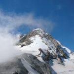
Mt Hood finally “peaks” its head through the trees after we’d turned down the Timberline Trail
If you want to come in from the town of Zigzag, from the Zigzag store go north on Lolo Pass Road for 10.7 miles and take the second right at Lolo Pass onto Forest Road 18, following the signs for Lost Lake. You’ll be driving on gravel for 5.5 miles, and then on pavement for the next 5 miles. Turn right onto Forest Road 16, and follow the directions above to the trailhead.
The trail is located at the far end of the parking area. Follow this trail for about ¼ mile to its junction with the Vista Ridge Trail. Be sure to turn left before you reach the signboard. In other words, if you kept going straight instead of turning onto the Vista Ridge Trail, you’d run into the tree that has the sign “Vista Ridge Trail” on it. Turn left here.
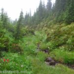
The trail climbs up through a pine forest, ascending the hillside. There are no views here, and for most of the hike you will be in a forest, although there should be some peek-a-boo views along the trail. However, you are on a ridge, so the trail looks fairly level most of the way out to Owl Point (except for the first part, where it climbs up to the ridge). I did not hike all the way out, but the views are supposed to be outstanding from Owl Point, as well as from the spur trail to The Rockpile and descending to Perry Lake (if you want a longer hike).
 and Mt Rainier as seen from the Timberline Trail")
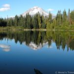
Mt Adams (right) and Mt Rainier as seen from the Timberline Trail
Unfortunately for us, when we got to the Vista Ridge Trail, we turned right instead of left. The reason for this is that someone had removed the signs for everything going left. Even the Vista Ridge Trail sign only pointed right instead of in both directions. The person had also tossed a few sticks across the trail to the left. I don’t know why; maybe there’s a good explanation for it. If someone knows what it is, please comment and tell me.
So, we turned right and went to the signboard and wilderness registration kiosk. Then we continued hiking through the pine forest (towards the Timberline Trail and Elk Cove). For being called the Vista Ridge Trail, it certainly didn’t have any vistas. In fact, the entire time we were hiking this trail, we never came out of the trees! We finally reached the Timberline Trail after about 3 miles. By this point we were running out of time, and needed to turn back, but we did turn left (towards Elk Cove) and walked down the Timberline Trail for a short distance. Here we got some really awesome views of Mt. Hood, as well as Mt. Adams, Mt. Rainier, and Mt. St. Helens. It was especially nice because the huckleberry bushes were in color, and the flaming red bushes and the mountain were very pretty.

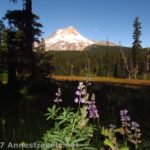
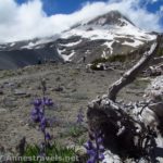
Mt Hood from the Timberline Trail
Both of these hikes are better in the afternoon (because of where the sun is), but if you have to do it in the morning like we did, do it early before the sun gets high and washes everything out. That’s my photography tip for this post 🙂
Trail 
Road
Signs
Scenery
Overall Rating:
This Week’s Featured Product!
Explore 85 different hikes in this book! It’s a year-round guide, so you can go hiking any time of year with this one.

Pingback: Epic Hiking Fail to Epic Hiking Success - Anne's Travels
Pingback: Owl Point in the Clouds - Anne's Travels