

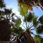
The Palm Bowl, as seen from above
In a previous post, I told about the Borrego Palm Canyon Nature Trail in Anza Borrego Desert State Park. However, you really haven’t seen a large oasis in the middle of the desert in this park unless you’ve climbed above the Palm Bowl in the southern part of the park. Here, more than 100 palm trees have grown over what must be an underground stream, and the views from above are truly worthy of a desert movie flick!
To get to the Palm Bowl, take S-2 16 miles northwest of the town of Ocotillo, or take S-3 out of Borrego Springs, then turn right on CA-78 W for 7 miles, then turn left on S-2 and drive 30 miles. Either way, you need to turn into the Mountain Palm Springs Campground. After you turn into the campground, stay right and drive towards the dirt parking lot. However, I wouldn’t try driving all the way to the parking lot if you don’t have high clearance. There is a large dip to go over to get into the parking lot, and we would have bottomed out in our high clearance van in one place had we tried it. You can park on the road side of dip, and it’s only a few yards more to walk. With a less-than-2-mile RT hike, a few more yards isn’t too bad.

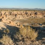
First Glimpse of the Palm Bowl
The trail isn’t particularly easy to find. It starts at the end of the parking lot farthest from the campground, and once you find it is pretty distinct and easy to follow. The trail winds its way up Surprise Canyon (I wonder what the story is behind that name!) for a ¼ mile or so until you come to a place where the trail splits. One fork goes up onto a badland-like dune, while the other stays down nearer the creek bed. It really doesn’t matter which one you take, because both will lead you to the Palm Bowl around the next bend. However, on top of the dune is a sign, so you can climb up to read that if you want. Just remember that you will have to climb back down the dune if you decide to take that route!

Approaching the Bowl
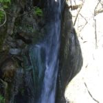
Another ¼ mile or a little less from the trail split, you will come around the bend and see the Palm Bowl itself. That’s pretty impressive, and very pretty, especially in the early afternoon—too late in the day (or probably too early) and the trees are in shadow. This is a good hike to do in the middle of the day, if you can stand the desert heat of California. From here, the trail goes up into the palm bowl itself. Be careful in the bowl, as a fire has gone through here, and the dirt and tree trunks will stain black anything that comes in contact with them.

High above the palm trees
Over to the left side of the palm trees, looking like it winds its way up the side of a steep, rocky hill, is a trail. There is a sign pointing up the trail; I believe it says something about another grove of palm trees. We hiked the trail as far as we could, and never found another grove, so don’t ask me what that’s about. However, if you go up this trail a little ways, you can look back down at the palm bowl, and it’s worth the hike just to do this. Somehow, seeing it from above is so much more impressive, and gives a totally new meaning to “streams in the desert”.

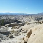
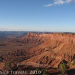
View from the top of the hill, just before sunset
If you continue up the rocky trail, it will finally flatten out at the top (up until now, it’s been steep, rocky switchbacks). From the top of the hill you can no longer see the palm bowl, but in its place is a vista of a barren, rocky, deserted, desolate land. I have never seen such a desolate sight except in Death Valley, and this is very different because here it is very rocky. You can see a road, but that’s the only real sign of civilization. The forsakenness of the view makes the palm trees, when you can see them again, seem even more special.

Sunset in the Bowl
We didn’t find that the views improved much more if you continued following the trail, but you’re welcome to continue on the fairly flat trail along the rocky top of the hillside. This would be very hot and exposed in the middle of the day, although it wasn’t too bad in the evening.
Return by the way you came. We never found the palm bowl to be terribly busy, and almost no one we saw went up to the top of the rocky hill. The palm bowl isn’t a deserted destination, but it’s a lot less visited than Borrego Palm Canyon Nature Trail!
Fees: None
Trail 
Road
Signs
Scenery
Overall Rating:
This Week’s Featured Product
Explore Anza-Borrego and beyond in this guide to the park and the region.
I like it! Your post is really good providing good information. I liked it and enjoyed reading it. Keep sharing such important posts. I am very much pleased with the contents you have mentioned.I wanted to thank you for this great article. I enjoyed every little bit part of it and I will be waiting for the new updates. I really appreciated this post. Just want to say thank you for the information you have shared. Just continue writing this kind of post. Thanks.
We took this trail to Palm Bowl Grove on Sunday, Mar 24, 2013. A beautiful day in the 80s, starting out from the Mt Palm Spring campground. The hike to the Palm Bowl is probably the prettiest trail we’ve hiked in the area and relatively easy. After reaching the grove, we continued up another steep trail, up a ravine that we discovered at the left of Palm Bowl Grove thinking it would eventually come out on the other side. We had heard a rumor that there was a trail that cut back over to the Southwest Grove. (This is not it) We hiked approximately 1.75 hours further, up through the ravine, more technical and challenging. After a boulder hopping, steep incline of about 2 miles, the sandy wash flattened out into a high saddle between 2 huge mountain ridges that ran North/South with a easy sandy wash. We were on the back side of the mountain. We kept thinking the saddle would soon turn left/east, back towards the campgrounds or around the ridge but the ridge kept going south with no way around east, at least as far as we could see. . The wash/trail finally started declining down and we kept going a bit farther until we overlooked a huge wash many miles down below that probably is the one that goes back through Bow Willow campground. At this point, we decided to go back because we were running out of time and we didnt want to be caught hiking after dark. It was a long ways down to that big wash. We also were not sure if the big wash we saw below actually was the one that goes back to Bow Willow and there weren’t enough hours of daylight left to test the route. This trail is not marked on any maps we have but it would be nice someday to follow it all the way to the bottom to see where it actually came out or if it even joined into any of the established trails to complete a loop back to Mt Palm Spring camp… maybe next time.
I’m really really interested by looking at your site. It gives high caliber posts and information. Continue the good work!
My brother recommended I might like this blog. He was, for once, totally right. This post made my day. You can’t think of how much time I had spent looking for this information! Thanks!
Really good one! Helpfull to all.Thanks for your post.
Pingback: 5 Best Hikes in Anza Borrego Desert State Park - Anne's Travels
Pingback: Joining in God’s Pleasure - Anne's Travels