
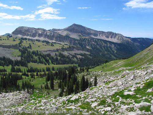
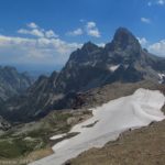
Views of Housetop Mountain from the “trail” beyond the pass at the head of Upper Darby Canyon
A few months ago, I posted about finding fossils in Upper Darby Canyon on the west side of the Tetons. Well, my goal that day wasn’t fossils; in fact, I didn’t even know they existed until they appeared in boulders all around me. My intent was on the pass above Upper Darby Canyon, where I hoped to get over to the Teton Crest Trail and then to the Death Canyon Shelf (which turned out to be way to long for a day hike, but more on that later). As it turned out, we got to the pass above Upper Darby Canyon, then along the slopes of Fossil Mountain to some views over the Teton Crest Trail. I won’t say it was anywhere near as spectacular as Table Mountain, but it was certainly a nice view and a great adventure!
Quick Stats
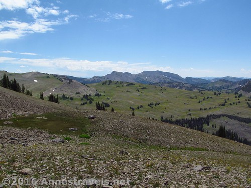
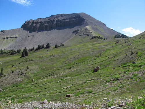
Views from the slopes of Fossil Mountain into Grand Teton National Park and the Teton Crest Trail
There are two ways to access Upper Darby Canyon. First, you can follow the trail, then boulder scramble up to the pass. That was the way we went out. But some of my group isn’t great at boulder scrambling, so on the way back we took the second route: what would be a short bushwack, then strolling up through meadows with unique white rocks strewn about. The second route bypasses the fossils, but the walking is much easier.
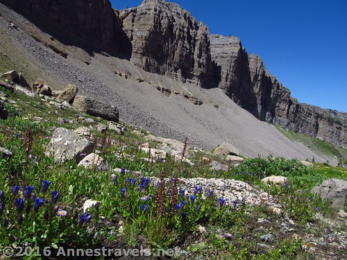
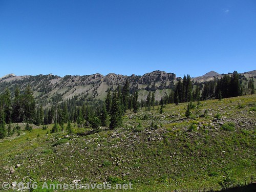
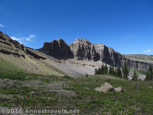
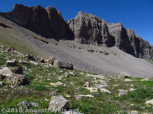
The cliffs along the Trail Route are very impressive
For the Upper Darby Canyon Trail Route: From the fossils, continue upward, choosing your route as best as possible. Staying near or just into the trees may give you a bit of a trail. The point is to keep climbing (and keep looking back and up from time to time – the canyon walls are very impressive!) Eventually, you’ll come to the head of the canyon. A trail strikes upward, switchbacking into the right side of the pass between Fossil Mountain (left / east) and an unnamed ridge. It’s about 2.5 miles from the fossils to the pass.
The same cliffs from the Meadow Route
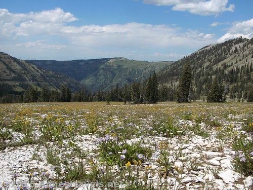
For the Upper Darby Canyon Meadow Route: About 2.9 miles from the parking area, while still on the main trail and before reaching the waterfall (you’ll still be about 0.25 miles from the waterfall), strike left (south) off trail into the trees / bushes. Bushwack lightly uphill into more open meadows. Depending on your exact route, there may be more trees to bushwack through before reaching the open meadows proper. Note that the lower meadows have waist-deep grass and shrubs, while as you climb higher, the vegetation becomes more scrubby and the walking is easier, to the point where the grass is less than 4 in. tall (at least in August). If unsure of your direction, keep walking upward and southeast, shooting for the pass at the head of the valley (or Fossil Mountain – it may be easier to see than the pass). The views in this section are mostly of Fossil Mountain and the unique white rocks that litter the ground, though as you go higher you can look over to the right and see some pretty impressive cliffs. It’s still easy walking compared to a rock scramble. About 2 miles after leaving the trail, you should arrive in the middle of the pass between Fossil Mountain (left / east) and an unnamed ridge at the head of Darby Canyon.
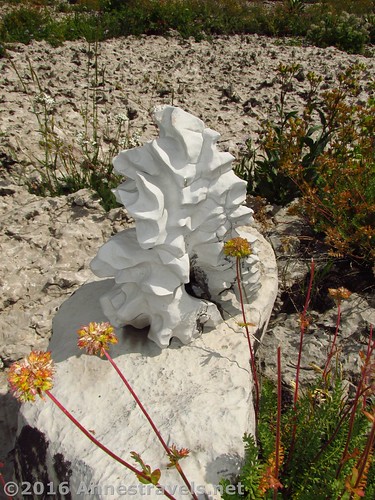
But in exchange for the cliff views, on the Meadow Route you get rock formations like this one
The views from the pass are ok, but nothing outstanding. (By the way, it looks like it would be pretty easy to scale Fossil Mountain from here – just a scramble up – but it was a lot further than any of us wanted to go that day.) However, we were all hungry and tired, so we ate our second lunch (the first lunch had been above the fossils) and debated what to do.
Descending the southern side of the pass
The fall out was that half of the group would go back down through the trees that separates the Trail Route from the Meadow Route (where they thought they’d seen a trail – I do think they were right, too), while the rest of us would continue a little way to see if we could find a decent view. I’m not real into splitting up, but sometimes it’s just the way things work out.
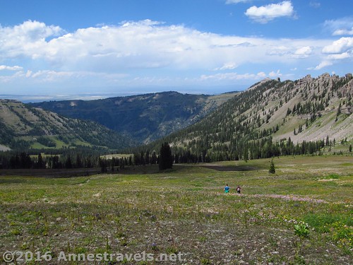
On the “trail”
So, we continued down the “trail” such as it was on the other side of the pass. Well, that didn’t work out so well – just a very rocky, extremely steep and slippery route that none of us wanted to climb back up! And it became pretty obvious that we weren’t going to make it to the Teton Crest Trail, like I’d wanted to. So after 0.5 miles, we turned around.
Limited views from the “trail”
But we still hadn’t found a view. So we did what I recommend you do: we struck off-trail along the side of Fossil Mountain, staying more or less on elevation with the pass.
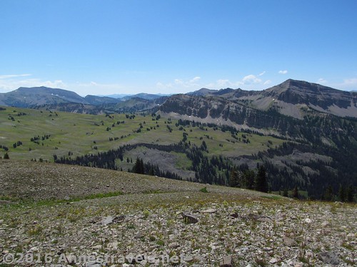
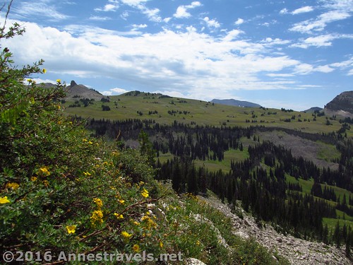
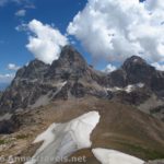
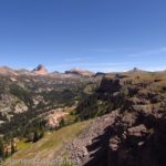
Housetop Mountain (right) from the slopes of Fossil Mountain
At the other side, we finally found our view. Wow! It really was nice, especially toward Housetop Mountain (to the right) and you could see quite a bit of the Teton Crest Trail winding its way across meadows. It would have been even nicer on a sunnier day!
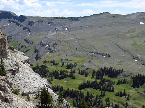
Looking down on the Teton Crest Trail from Fossil Mountain
But time was getting on, and we didn’t want to make the rest of the group wait up for us… so we’d have to put off any more adventures (other than finding our way back to the van) until another day…
Descending back through the meadows (Meadow Route)
Round Trip Trail Length: Approximately 14 miles via the Trail Route; about 12 miles via the Meadows Route
Lowest Elevation (parking area): 7,047 ft.
Highest Elevation (view on Fossil Mountain): 10,172 ft.
Net Elevation Change: 2,765 ft.
Amenities: None
Fees: None
Trail Notes: If you’d like, you can add about a half mile to the Meadow Route and walk up and see the waterfall. It’s quite impressive and you can see the famed Wind Cave at the same time. Whichever route you take, use route-finding skills and have a good topo / gps with you – this is wild country and cell phones don’t work very well.
Be Bear Aware – carry bear spray and know how to use it!
Looking across Upper Darby Canyon (on the Trail Route) at Mount Bannon (Right)
Trail 
Road
Signs
Scenery
Would I go 100 miles out of my way for this?
Overall Rating:
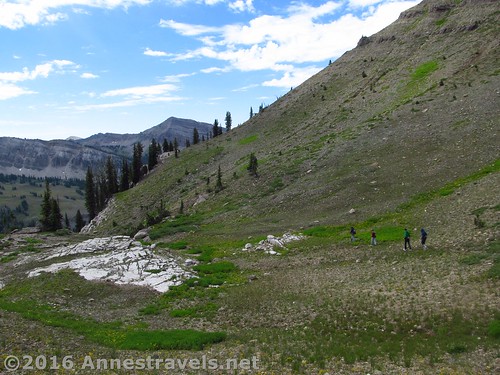
Ascending the Trail Route up Upper Darby Canyon – this is a meadow section; you can’t see the rocks from here.
Key GPS Coordinates
Both routes
Parking: 43.68639N / -110.96908W (43° 41′ 11.004″ / -110° 58′ 8.688″) (7,047 ft.)
Trail beginning: 43.68662N / -110.96880W (43° 41′ 11.8314″ / -110° 58′ 7.68″) (7,057 ft.) (ended 12.6)
Enter Jedidiah Smith Wilderness: 43.68467N / -110.95731W (43° 41′ 4.8114″ / -110° 57′ 26.316″) (7,141 ft.) (0.6)
Looking back down Upper Darby Canyon (Trail Route)
Trail Route
Cave / waterfall view: 43.66692N / -110.95502W (43° 40′ 0.9114″ / -110° 57′ 18.072″) (8,433 ft.) (3.1)
Cave trail junction: 43.66655N / -110.95465W (43° 39′ 59.58″ / -110° 57′ 16.74″) (8,456 ft.) (3.2) (turn left next to memorial)
Beginning of fossils: 43.65742N / -110.94730W (43° 39′ 26.712″ / -110° 56′ 50.2794″) (9,022 ft.) (4.1)
Regain trail: 43.65236N / -110.93098W (43° 39′ 8.496″ / -110° 55′ 51.528″) (9,816 ft.) (5.7)
Pass: 43.65145N / -110.92734W (43° 39′ 5.2194″ / -110° 55′ 38.424″) (9,945 ft.) (5.9)
About as rocky as the Meadow Route gets
Meadows Route
Leave trail: 43.66806N / -110.95249W (43° 40′ 5.0154″ / -110° 57′ 8.9634″) (8,418 ft.) (2.9)
Pass: 43.65145N / -110.92734W (43° 39′ 5.2194″ / -110° 55′ 38.424″) (9,945 ft.) (5.0)
Views from Fossil Mountain over the meadows of Grand Teton National Park
Beyond the Pass
Turn around going down other side of pass: 43.64913N / -110.92574W (43° 38′ 56.8674″ / -110° 55′ 32.664″) (9,585 ft.) (6.5)
Mountain view: 43.64984N / -110.92123W (43° 38′ 59.4234″ / -110° 55′ 16.4274″) (10,172 ft.) (7.1)
Return to the pass: 43.65173N / -110.92652W (43° 39′ 6.228″ / -110° 55′ 35.4714″) (9,991 ft.) (7.6)
(“Beyond the Pass” mileages reflect that I came up via the Trail Route.)
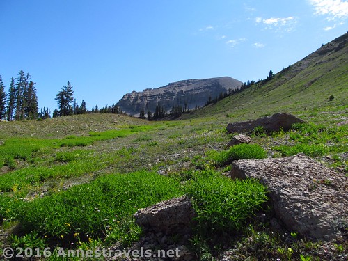
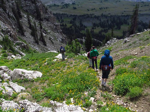
Heading upward on the Trail Route
The gpx file for my hike up Darby Canyon can be downloaded – please note that this and the GPS Coordinates are for reference only and should not be used as a sole resource when hiking this trail.
Download GPX File size: 306.2 KB Downloaded 137 times
Cliffs along the Trail Route
(Note: I do my best to ensure that all downloads, the webpage, etc. are virus-free and accurate; however, I cannot be held responsible for any damage that might result, including but not limited to loss of data, damages to hardware, harm to users, from use of files, information, etc. from this website. Thanks!)
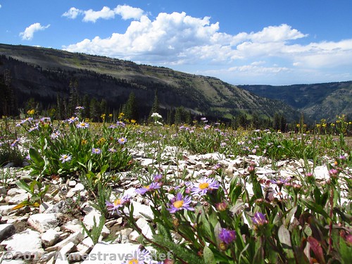
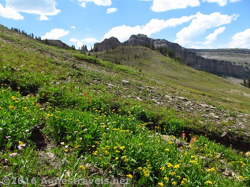
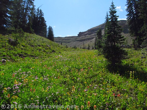
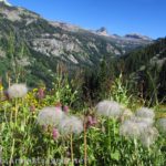
Wildflowers along the Meadow Route
Getting to Upper Darby Canyon
If coming from the South (or from Jackson Hole): From the town (ok, hamlet) of Victor, ID, continue north on ID-33W for 5.3 miles. Turn right onto W 3000 S (if you get to the Spud Drive-In Theatre, you’ve gone too far) and drive 3.2 miles; then turn right on S Stateline Road (yes, you’re reentering Wyoming) for 0.1 miles. The main road will take a sharp turn to the left; stay to the main road to continue on Darby Canyon Road for 4.2 miles to the large – if rambling – parking area. The roads are in good condition are should be doable by passenger cars, even though most of the vehicles I saw were pickups and jeeps (but maybe that just reflected the nature of the locals?).
Fossil Mountain from high on the Trail Route
If coming from the North: From Driggs, ID, drive south on ID-33E exactly 3 miles. Pass the Spud Drive In Theatre, then turn left on W 3000 S. Follow the directions above to the parking area.
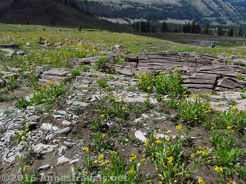
Wildflowers along the Meadow Route, along with some other odd rocks (have you noticed that Upper Darby Canyon is a great place to see interesting rocks?)
Note: A car GPS is quite helpful in getting to this place – just put in the coordinates and let Garmin do the rest!
Zoom map out to browse nearby hikes & places of interest
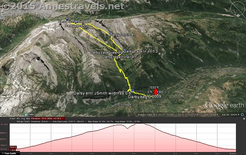
Visual trail map and elevation plot for hiking Upper Darby Canyon. the right of the loop is the Trail Route, while the left follows the Meadow Route. North is down.
This Week’s Featured Product!
Looking for more hikes in the Tetons? Like most books, this one focuses on the eastern side of the mountains, but it’s pretty comprehensive with nearly 90 different trails described in detail.

Pingback: Waterfalls & Fossils: Upper Darby Canyon - Anne's Travels.
Pingback: 12 Best Day Hikes in Grand Teton National Park - Anne's Travels
Pingback: The Glory of the Lord Covers the Earth - Anne's Travels