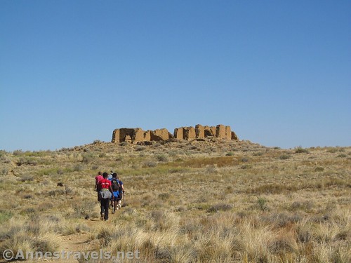
Walking toward New Alto
There are members of my group who have wanted to hike the Pueblo Alto Loop for about 23 years. That was when they saw a photo of Pueblo Bonito on the cover of their AAA road map and decided to stop by. In fact, back then, the road in was from the north and went directly by Kin Klesto and the other ruins that are now only accessible by foot or bicycle. We couldn’t do the hike then – a three mile hike was a serious reason for pause, and the Pueblo Alto Loop is about 6 miles long. But we finally did it. And the views from above of Pueblo Bonito and Kelso Ketl, not to mention the ruins of New Alto and lots of views of desert and ancient civilization, make it well worth the hike!
Quick Stats
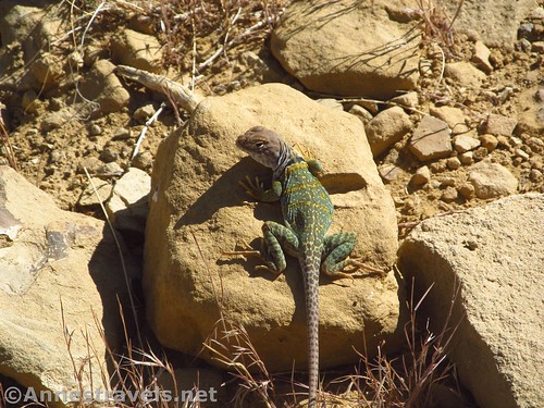
Common Collared Lizard near the ruins of Pueblo Alto
The trail begins at the end of the road near the gate and the picnic tables with the thatch-style roof. Make yourself out a free permit near the big “Stop” sign next to the gate, then walk beyond the gate and follow the old road to an intersection at mile 0.25. To the left are some primitive restrooms, and the road goes straight. Turn right toward Kin Klesto (it’s very obvious). You can walk around the ruin of the pueblo, but eventually you’ll want to be on the far (cliff) side and take the trail that goes up the cliff face.
Kin Klesto is camouflaged by the cliff behind it
Even the first time we visited, this next part was our favorite (second only to exploring Pueblo Bonito). The trail winds its way up through a rock field (watch for signs showing which way to go) and then enters a crack in the rock, allowing access all the way up to the mesa top. It’s a really neat place, and on top of that, it’s also nice and cool on a hot day!
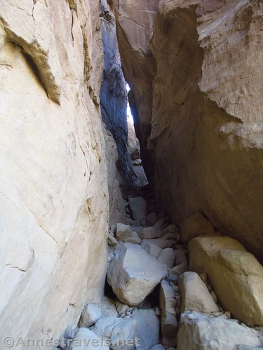
Walking up the “crack” to the mesa top
Atop the mesa, follow cairns, signs, and occasional footpaths across the slickrock. You’re generally following the cliff edge, but thankfully not too near (most of the time). You’ll pass “Terrace View” and the “Stone Circles”, as well as the “Shrimp Burroughs” at miles 0.7 and 0.8 and 1.0, respectively.
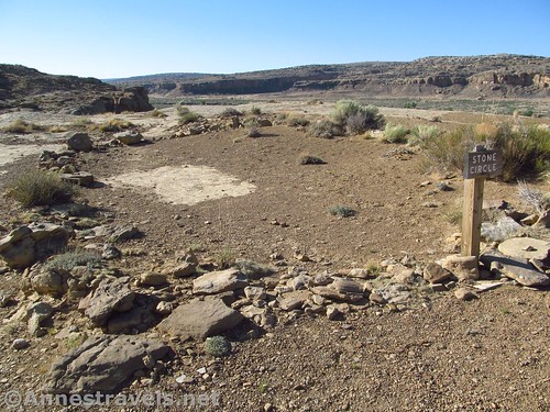
The Stone Circle
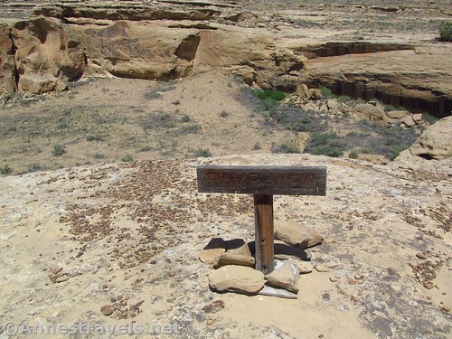
At 1.1 miles from the trailhead, the trail splits. You can walk the short distance to the Pueblo Bonito Overlook or do it on the way back.
Looking back down on the parking area and Pueblo del Arroyo
We turned left (leaving Pueblo Bonito Overlook for the afternoon – from driving in, I knew Pueblo Bonito would be in shade for another hour or so, so I wasn’t keen on doing the overlook too early). We then turned left again 0.02 miles later to hike the Pueblo Alto loop clockwise (Pueblo Alto first, views over Pueblo Bonito and Kelso Ketl later).
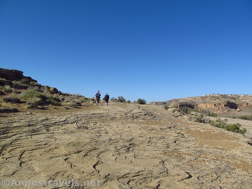
Walking the slickrock that makes up a good portion of the trail
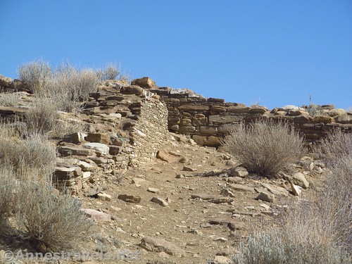
The trail ascends higher on the mesa, passing the Chacoan Steps and Chacoan Road at miles 1.4 and 1.6. A tenth of a mile later, a well-worn social trail splits to the left. Follow this to arrive at New Alto (or you can continue another short distance to a four-way junction and turn left – many trails lead to New Alto!)
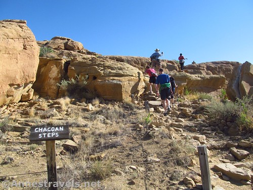
Chacoan steps – and modern steps!
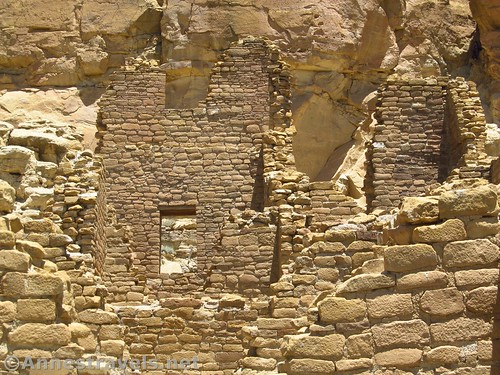
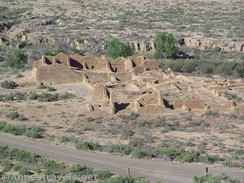
You can basically just wander all around New Alto. There is some defacing on the trail side, but other than that, it’s just a fairly well-preserved ruin. I very much enjoyed the ability to walk through it, examine the stonework close up, and to sit in its shade.
Inside of New Alto
Back at the trail, a sign talks about the two Altos; Pueblo Alto is on the right side of the trail and is mostly a dirt-covered ruin. There are social trails that go around it if you so desire to follow them (I did, at least to an extent).
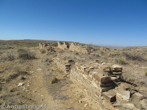
Social trail along the walls of Pueblo Alto
After examining Pueblo Alto, take the main trail that heads right (with its back to New Alto – the trail does a 90 degree turn to the right near the turnoff for New Alto). The trail rambles along the top of the mesa through desert scrub. I enjoyed the sheer dryness of it and the views down into the surrounding valleys and buttes.
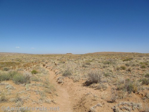
Trail across the mesa after leaving Pueblo Alto
At last the trail descends to cross slickrock again. Follow the cairns. The park service does a pretty good job of making sure you won’t lose the trail. Almost a mile from Pueblo Alto, a sign marks the Jackson Staircase (across the side canyon). The stairs were made by Ancient Puebloans to give them access to the Great North Road (which went to the Four Corners area), but the stairs were named for the man who discovered them in 1877 – William Henry Jackson, who also photographed Yellowstone, the Tetons, and Mesa Verde, and whose pictures helped to establish Yellowstone as the world’s first national park. (There’s your history for today!)
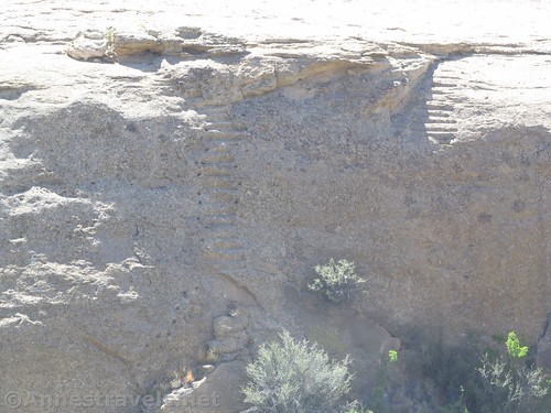
A very poor picture of the Jackson Staircase
While walking the slickrock, look for what appears to be rusting pipes. These are actually shrimp boroughs, filled with iron deposits.
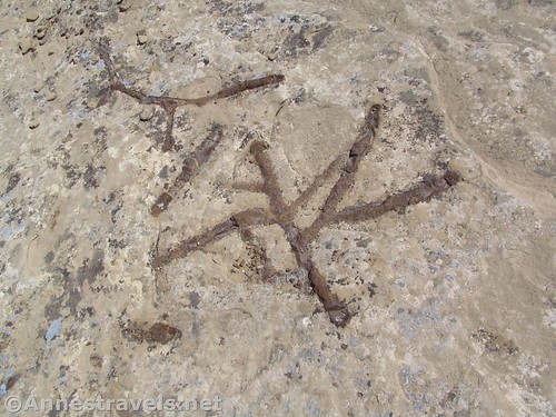
Shrimp burrows
About mile 3.6, the trail descends to a lower part of the mesa via a slot. It’s pretty tight, but doable. The trail at this point begins to work its way back toward your starting point via the mesa rim. Take in views of the Road Alignment about mile 4 and Ramp View a tenth of a mile later.
View of the ramp
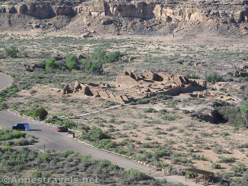
Walking along from here, there are good views over Kelso Ketl and distance views of Pueblo Bonito. Unfortunately, the park service has closed the area where you used to be able to look down directly on Pueblo Bonito. I was definitely sad, because I had been looking forward to that view for weeks, if not months (the last time we visited, c.2003, you could still walk along the rim to the view, even though it was beyond the actual Pueblo Bonito Overlook).
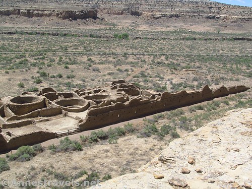
Chetro Ketl from above
Right about mile 5, the trail finishes its loop. From here, I turned left to scramble down a short step in the slickrock to overlook Pueblo Bonito. It’s not as good as the overlooks I had on earlier trips, but it’s still neat to see the pueblo from above (and all the stabilization they have put in place to keep the walls safe!)
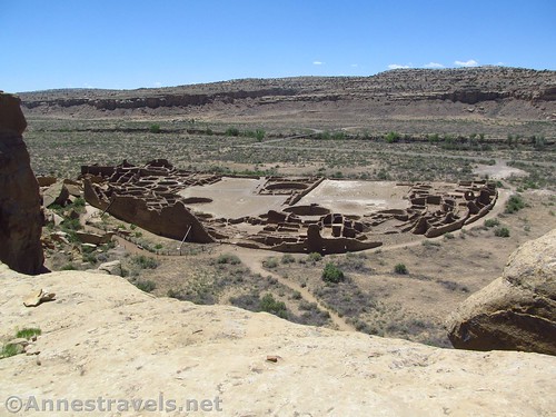
Pueblo Bonito from the overlook
Then it’s a mile back along the rim, down the slot, around Kin Klesto, and back down the old road to your vehicle. Overall, it’s about a 6 mile hike, and I’m so glad I finally got to do it!
Looking down on Kin Kelso from near the exit from the slot
Round Trip Trail Length: I finished at 6.0 miles. That does take into consideration wandering a little around New Alto and Pueblo Alto.
Elevation Change: 327ft. (6,088ft. to 6,415ft.)
Facilities: Primitive restrooms near Kin Klesto; a couple picnic tables at the trailhead
Fees: $25/vehicle, valid 7 days. National Park & Federal Recreation Passes also accepted.
Trail Notes: There are drop-offs – it’s not too hard to stay away from the edge, but those with vertigo may want to skip this trail. Also, keep a close eye on children. I loved this trail as a child, and every child I’ve taken on it has loved it (especially hiking up the crack to the mesa top). But we also knew to stay away from the edge 🙂
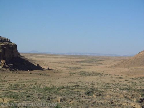
Views out of Chaco canyon to the plains and mountains
Trail 
Road
Signs
Scenery
Would I go 100 miles out of my way for this?
Overall Rating:
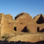
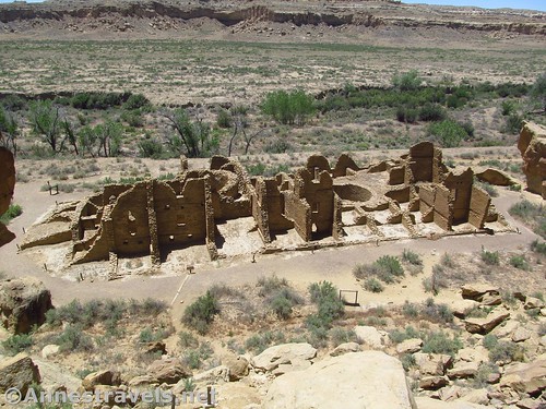
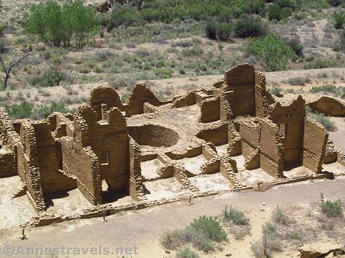
Ruins of Pueblo Alto
Key GPS Coordinates for the Pueblo Alto Loop
Trailhead: 36.0627500°, -107.9658667° (N36° 03.765′ W107° 57.952′ / 36°03’45.9000″, -107°57’57.1200″) (6,097ft.) (0.0) (end 6.08)
Penasco Blanco Junction: 36.0648500°, -107.9697333° (N36° 03.891′ W107° 58.184′ / 36°03’53.4600″, -107°58’11.0400″) (6,089ft.) (0.25)
Kin Klesto: 36.0649500°, -107.9697833° (N36° 03.897′ W107° 58.187′ / 36°03’53.8200″, -107°58’11.2200″) (6,088ft.) (0.28)
Pueblo Alto Trail: 36.0652833°, -107.9699000° (N36° 03.917′ W107° 58.194′ / 36°03’55.0200″, -107°58’11.6400″) (6,105ft.) (0.35)
Terrace View: 36.0654167°, -107.9660333° (N36° 03.925′ W107° 57.962′ / 36°03’55.5000″, -107°57’57.7200″) (6,199ft.) (0.69)
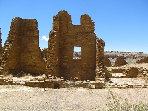
Another pueblo – I’m not quite sure which one this is
Stone Circles: 36.0640333°, -107.9651500° (N36° 03.842′ W107° 57.909′ / 36°03’50.5200″, -107°57’54.5400″) (6,210ft.) (0.85)
Shrimp Boroughes: 36.0632333°, -107.9637000° (N36° 03.794′ W107° 57.822′ / 36°03’47.6400″, -107°57’49.3200″) (6,211ft.) (1.01)
Pueblo Bonito Overlook Junction: 36.0622167°, -107.9626167° (N36° 03.733′ W107° 57.757′ / 36°03’43.9800″, -107°57’45.4200″) (6,225ft.) (1.14)
Pueblo Alto Loop Junction: 36.0623167°, -107.9624000° (N36° 03.739′ W107° 57.744′ / 36°03’44.3400″, -107°57’44.6400″) (6,230ft.) (1.16)
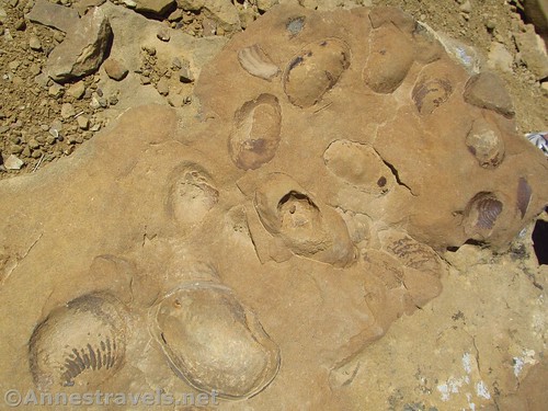
Fossils in the rocks along the trail
Chacoan Steps: 36.0660500°, -107.9600000° (N36° 03.963′ W107° 57.600′ / 36°03’57.7800″, -107°57’36.0000″) (6,314ft.) (1.47)
Chacoan Road: 36.0674333°, -107.9592000° (N36° 04.046′ W107° 57.552′ / 36°04’02.7600″, -107°57’33.1200″) (6,362ft.) (1.61)
New Alto Junction: 36.0685500°, -107.9587833° (N36° 04.113′ W107° 57.527′ / 36°04’06.7800″, -107°57’31.6200″) (6,393ft.) (1.70)
New Alto: 36.0697333°, -107.9597000° (N36° 04.184′ W107° 57.582′ / 36°04’11.0400″, -107°57’34.9200″) (6,415ft.) (1.81)
Pueblo Alto Junction: 36.0694833°, -107.9585000° (N36° 04.169′ W107° 57.510′ / 36°04’10.1400″, -107°57’30.6000″) (6,395ft.) (1.93)
Kin Klesto while hiking down the cliff face
Regain Trail after Pueblo Alto: 36.0691333°, -107.9576000° (N36° 04.148′ W107° 57.456′ / 36°04’08.8800″, -107°57’27.3600″) (6,407ft.) (2.19)
Jackson Steps: 36.0677333°, -107.9442500° (N36° 04.064′ W107° 56.655′ / 36°04’03.8400″, -107°56’39.3000″) (6,365ft.) (3.08)
Slot: 36.0616000°, -107.9474667° (N36° 03.696′ W107° 56.848′ / 36°03’41.7600″, -107°56’50.8800″) (6,356ft.) (3.66)
Road Alignment: 36.0613333°, -107.9514833° (N36° 03.680′ W107° 57.089′ / 36°03’40.8000″, -107°57’05.3400″) (6,225ft.) (4.06)
Ramp View: 36.0624833°, -107.9511333° (N36° 03.749′ W107° 57.068′ / 36°03’44.9400″, -107°57’04.0800″) (6,203ft.) (4.16)
Views over Kelso Ketl: 36.0613500°, -107.9539167° (N36° 03.681′ W107° 57.235′ / 36°03’40.8600″, -107°57’14.1000″) (6,217ft.) (???)
Pueblo Bonito Overlook: 36.0618667°, -107.9621167° (N36° 03.712′ W107° 57.727′ / 36°03’42.7200″, -107°57’43.6200″) (6,217ft.) (5.08)
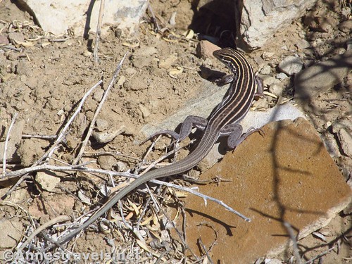
A lizard better known as a New Mexican Whiptail
The gpx file for the Pueblo Alto Loop can be downloaded – please note that this and the GPS Coordinates are for reference only and should not be used as a sole resource when hiking this trail.
Download GPX File size: 119.8 KB Downloaded 85 times
(Note: I do my best to ensure that all downloads, the webpage, etc. are virus-free and accurate; however, I cannot be held responsible for any damage that might result, including but not limited to loss of data, damages to hardware, harm to users, from use of files, information, etc. from this website. Thanks!)

Zooming in on Pueblo Bonito
Getting to the Pueblo Alto Loop
From I-40, take Exit 53 and turn north onto NM-371N. After 28.5 miles, turn right onto NM-57 and drive 13.3 miles. Turn left (following the sign for Chaco) to stay on NM-57 (the road is now dirt, suitable for low clearance vehicles except after storms which may make washes rough until graded) for another 19.2 miles. Once in the park, turn left on the one-way Chaco Canyon Loop Road about 4 miles to the parking area for Pueblo del Arroyo, etc.
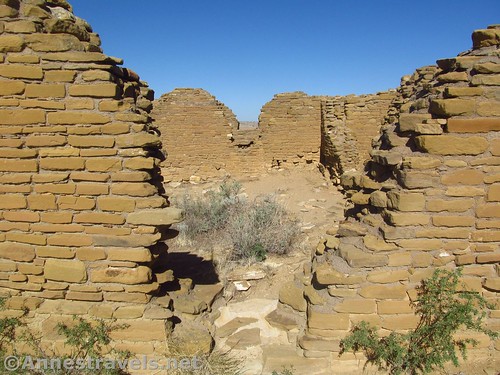
Kin Klesto. It’s a lot of fun to take pictures through the windows.
Alternatively, from the east (US-550) turn onto Road 7900 (signs point toward Chaco Culture National Historical Park) – the turn is on the south side of the road about 15 miles west of Counselor or 3 miles south of Nageezi. The road is now dirt, but passable to low clearance vehicles in dry weather. Continue to follow the main dirt road (signs mark any confusing junctions) for about 22 miles to the Chaco Culture Park visitor center. Continue straight a short distance, then continue straight onto the one-way Chaco Canyon Loop Road for about 4 miles to the parking area for Pueblo del Arroyo, etc.
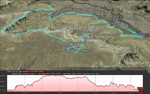
Visual trail map and elevation profile for hiking the Pueblo Alto Loop
Zoom map out to browse nearby hikes & places of interest
This Week’s Featured Product!
For even more hikes in New Mexico – including an extensive section on northern New Mexico – check out this book!