The Shoe Tree–one of the oddities to be found along “The Loneliest Road in America”
On a recent trip, we were talking to a couple that we met on top of a cinder cone (literally—we’d climbed to the top, and they came up right as we were about to climb down). “You’ve got to do Route 50 across Nevada,” they told us. “It’s not called “The Loneliest Road in America” for nothing, but the scenery is gorgeous.” The road happened to be in the direction that we were headed, so, intrigued, we decided to take the road from Fernley, NV to I-15 in Utah, where we could pick up I-70.
The road actually starts in Sacramento, California, but the “loneliest” part is the section of the road in Nevada. As I said before, we started down the road in Fernley (after taking I-80 from Reno). Be sure to stock up on supplies and gasoline here, because you won’t be seeing much of civilization for a while. There are a few towns along the road, but the prices are a bit outrageous, so it’s best to stock up here. There is a Wal-mart here, and if you’re like us, you’ll stock up on supplies there.
From Fernley, the road travels across scrubland, but honestly, the couple who told us about the road wasn’t joking that the scenery was spectacular. There may be sagebrush in the foreground, but beyond are hills, some of which have eroded sides, reveling layers of grey and brown rocks. There are also mountains which at some times of the year are studded with snow. As you get closer to the town of Ely (at the east of the road), the hills become more red and gold, and can make some pretty fantastic formation. I distinctly remember one valley—I think it was just to the west of Ely, but it might have been farther east—where the road literally passes through a “hole” between two huge rock towers or hills made of rock. In the late afternoon sunshine, the view was absolutely stunning. I wish I’d taken a picture.
Speaking of pictures…you may notice that I haven’t uploaded very many pictures for this post. I am very sorry that I didn’t take any more pictures of the road than I did, so maybe we’ll travel it again someday I then I can add more pictures.
Back to the west end of the road, the thing that the driver primarily noticed is that it is flat, straight, and you can see someone coming a very long ways away. I think the only time the road curves is to go through a town or to go in between two hills. There’s nothing to run into out there, so why make the road turn? Speaking of running into things, there basically isn’t any traffic coming towards you, either. They don’t call it “The Loneliest Road in America” for nothing! We joke with friends that when we saw a car coming towards us, both us and the people in the other car would wave with all our might—after all, we could go 100 miles without seeing anybody else! That’s not to say that we didn’t see any other cars—several cars that were going in the same direction as us passed us, and we certainly saw cars at a construction area along the road—but compared to most highways, it’s deserted.
There are quite a few little roads going off into the hills, and many looked like they’d be interesting places to explore someday (a lot of the land in that area is government-owned). We were sort of trying to “make tracks” home at that point, so we didn’t stop. Still, you could probably spend a week or more just exploring the different sites along the road.

All kinds of footwear has made its way onto the Shoe Tree
Near Middlegate is perhaps the most unique sight along the road. At a small, dirt pull-off on the north (left if you’re going east) side of the road is a tall cottonwood tree. That’s nothing new, as many of the washes have cottonwood trees growing in them, but this particular cottonwood has hundreds of shoes, boots, sandals, flip-flops, and even slippers hanging off of it. This so-called “Shoe Tree” is definitely worth a stop, if just to snap a picture to send home. It certainly is the weirdest looking thing, with shoes hanging all over it. Some of the shoes have fallen down and are in the wash, but other people have actually tied ropes to some of the footwear, and have slung them up in the tree as well. I gather that it’s the custom in the surrounding towns to take all of your old shoes out here and toss them into the tree. Whatever the custom, you’re free to bring along an old pair of shoes and give them a toss. A truck pulled in while we were admiring the tree, and the man who got out (who was from Utah) explained to us that he goes this way a few times each year, and he always takes his old shoes and those of his friends to toss up into the tree. My bother had worn out a pair of shoes on the trip, and we were planning on throwing them out along the way, so we decided to let them fly into the tree instead. It took us a couple of throws, but we did get them up. If you see a tiny pair of red shoes that say “Wee-bok” on them while you’re looking at the tree, those are the ones we threw 🙂

The shoes that we threw (the red ones, at least) 🙂
As you continue east, there are a few small tows. Typically there’s not much there; maybe a few houses, a few stores (some of them closed), and a gas station (if you’re lucky). They do break up the scenery, though, and if you’re into old towns, you’d probably find these fascinating. There are also a few larger towns that actually have restaurants, a library, churches, and a historical society, and these could probably be fun to poke around in for a few hours. Much of Route 50 followed the old Pony Express Route, and many of the towns were on that route, which makes them even more interesting to explore. In each town (both large and small) there is a place that you can go to get a stamp to prove that you actually traveled the road. This is a really cool feature, and many people take advantage of it to show off later to friends, family, and fellow travelers.
The town of Ely is the gateway into Great Basin National Park, and it is also one of the biggest towns on the road. Because of the park, there are more services than in most of the other towns on the road; if I recall correctly, there were outfitters, a real grocery store, several gas stations, and lodging facilities. Admittedly, the road isn’t as deserted after this, but the scenery is just as good, and in some ways better, because you are coming up towards Utah, and the red sandstone rocks that begin to dot the landscape are very pretty as well s awe-inspiring.
The state line comes not too long after Ely, and you enter Utah. However, just because you’re out of Nevada doesn’t mean that the scenery goes dead. Instead, you can see more typical Utah scenery, including huge sandstone rock formations. There are more towns along this section of road, and they typically have at least gas stations in them. Eventually, you will come to I-15. Route 50 does go north on this highway for a while, and then splits off again and goes south until it reaches I-70, which is the end of the road. We started out from Fernley around 9:00am and hit I-70 in the late afternoon. Thus, I’d guess that The Loneliest Road in America takes 6 or so hours to drive, minus stops to get gas, explore towns, or enjoy the landscape.
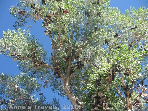
Looking high up into the shoe tree
Road 
Signs
Scenery
Overall Rating:
This Week’s Featured Product!
Visit some truly interesting and off-beat places in Nevada with this book!