

Do you love waterfalls? Do you wish that you could see an outstanding waterfall for every mile you hike? If so, the Trail of Ten Falls in Silver Falls State Park, Oregon is the trail for you. An 8.7 mile loop, there are ten waterfalls located along this trail (as the name suggests). Most of the falls are really quite spectacular, ranging in height from 27 ft. to 177 ft. For waterfall-lovers, this is paradise. There are also several ways to see some great falls while walking a shorter distance if you’re not up to a 9-mile jaunt. Thankfully, though, the trail is fairly flat, which makes it easier than other mountainous trails.
(Affiliate links are present on this page.)
To get to Silver Falls State Park coming from the south, on I-5 take exit 253, and head east on North Santiam Highway 22. Turn left on Hwy 214 (there should be a sign pointing towards Silver Falls State Park), and follow this road as it twists and turns through Oregon farmland for about 16 miles. The road will turn several times, so be sure to stay on Hwy 214, also known as Silver Falls Highway. If you’re coming from the north, exit I-5 at exit 271. Go east on Newberg Hwy, otherwise known as Hwy 214. You will follow Hwy 214 all the way to the park, but I won’t say this is easy! The road turns several times, and the street name changes constantly, so I’ll try to describe the route a bit. Not long after you start down the road, its name will change to Hillsboro-Silverton Highway. Keep going east, and the name will change to Mt Hood Ave when you cross N Front St. At the next major intersection, turn right onto N Pacific Hwy (99E & 214). Follow this until you reach Yount St; turn left on this. Quite soon, the road will turn, and you will again be on 214, now known as Silverton Rd, until the road turns again, and the name changes to Hillsboro-Silverton Hwy (I think we were on that once before…?!?). Then the name changes to Wilco Hwy NE and Hillsboro-Silverton Hwy. The road either has both names, or else it changes back and forth every other road! A little ways from here, Hwy 214 will turn right; take this turn. After going through a town (on the far side—I’m sorry, I’m not sure the name of the town, although it might be Mt. Angel), you will turn left to stay on Hwy 214, now only known as Hillsboro-Silverton Hwy. Follow this for quite a ways south and a little east until you reach the next large town (Silverton). After you enter the town, the road name will change to 1st St. You may never see the actual name changes, but if you do, then you’ll know you’re still on the right track! At E C St., Hwy 214 jags over a bit; so turn right on E C St. for one bock, and then turn left on N Water St. If you miss this turn and find yourself on Hwy 213, simply go one bock to the right, and you should be back on Hwy 214. At W Main St. the road name changes to S Water St. It should be fairly clear sailing from here, although Hwy 214 changes its name to Silver Falls Dr on the far side of Silverton. Just keep following Hwy 214 (Silver Falls Dr or Silver Falls Hwy) to the park (there should be signs). The total distance from I-5 is about 30 miles.

Once you’ve entered the park, you can park in any of the several parking areas near the South Falls Day Use Area. We parked in Parking Lot A, so that’s where I’ll start from. Wherever you park, you want to get to South Falls, so follow what signs you can find in that direction.
From Parking Lot A we headed over towards the restrooms, and then continued down the trail towards South Falls. This is the tallest waterfall in the park (177 ft.), and can be seen from several viewpoints. This part of the trail is paved, although I wouldn’t try taking anything on wheels (including strollers) down the hill into the canyon, as it is very steep and somewhat uneven. The trail goes around the pool that the waterfall falls into, then behind South Falls. Although it can be crowded, the falls is quite nice.

Continue behind the falls and around the other side of the pool. Then, instead of following the paved trail back towards the parking area, turn left at the bridge onto the unpaved Canyon Trail. About a mile from here, you will come to Lower South Falls. This is, in my opinion, one of the most impressive falls in the park (only outdone by North Falls, a little farther along the trail). It’s only 93 ft. tall, but it makes up for that in sheer beauty. Instead of dropping straight into a pool like South Falls, it falls onto some rocks before running down into the pool. Impressive! You can walk behind this falls as well, and the ferns and moss on the walls under the overhand are quite nice. Be aware that you will need to walk down 185 stairs to get to the falls.
Keep walking along the Canyon Trail. There are very few falls in this next section of trail, so you mostly are just hiking along the dirt, root-infested trail. There are bushes on either side, and the trail may feel a little grown in at times. The next falls you will see is Lower North Falls, 1.3 miles from Lower South Falls. This falls is not as impressive as the ones you’ve seen earlier. At only 30 ft. high, the water cascades down an incline that seems to usually have trees on it. It’s still nice, but not the same as some of the others you’ve already seen.

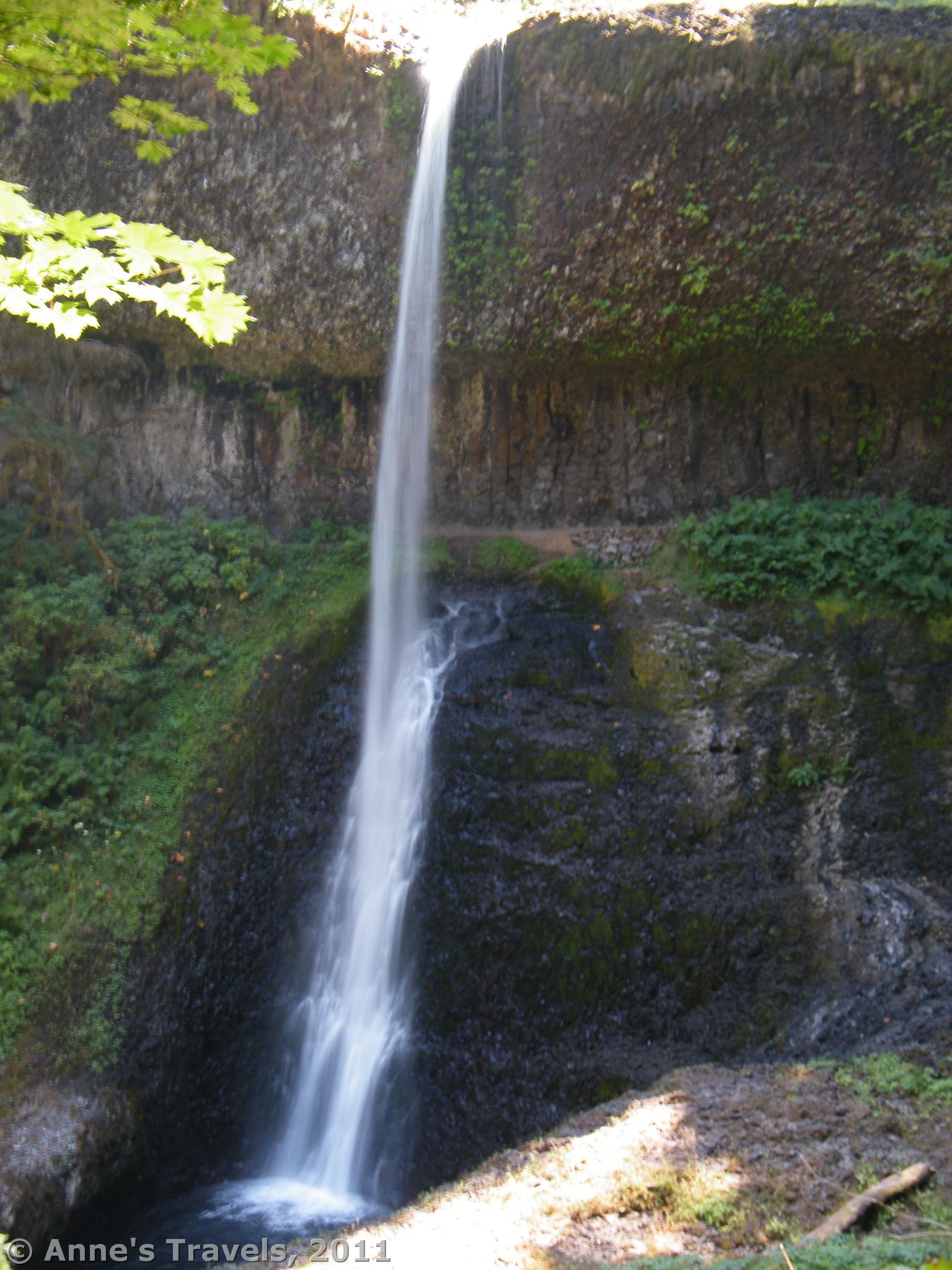
Not too far from here, on your left, a footbridge will take you across Hullt Creek and up a 0.1 mile trail to Double Falls. At 178 ft (combined), it is very nice, although there could have been more water going over it when we were there in August. I have a feeling that this falls would be more impressive in the spring or winter. The waterfall has a double drop, giving it its name. We stopped here to eat lunch on the numerous boulders at the base of the falls. If your children like playing in streams, this is the place to do it, as the stream isn’t so swift and the banks so steep that they might fall in.
Back to the main trail, keep walking for a little while more to Drake Falls. This is the shortest trail in the falls in the park, and, in my opinion, the least impressive. Part of the problem is that it is very difficult to get anywhere where you can get a good view, let alone a good picture, of the falls. So, keep walking to Middle North Falls. Again, it may be difficult to get a good view of this falls, but at 106 ft., it’s worth taking note of. You can take a side spur that will bring you behind the fall of water.

If it’s winter or spring, you may want to take a side trip to Winter Falls. The less-than-0.6 mile side trail goes along Winter Creek and up to the base of Winter Falls. From here, the trail steeply ascends the side of the canyon to the Winter Falls Trailhead. We actually climbed down and then back up instead of doing this side trail (not something I recommend—it’s really steep!). In August, Winter falls was a damp patch on the side of the canyon wall. So much for that steep climb! Anyway, I’ve seen pictures of it in the spring, and it’s quite nice then. Return to the main trail, and continue on to Twin Falls. Again, it’s hard to see these falls. The stream is split in two by protruding rocks, and becomes two cascades, landing in a pool 31 ft. below. My opinion, it’s worth noting, but not spending much time at.
For the next mile, the trail winds its way along Silver Creek (the stream that most of the falls are on). However, after this somewhat “boring” section (if you’re not fond of hiking through very nice woodlands), you will be rewarded with what I consider the most impressive falls in the park. North Falls is 136 ft tall, crashing down into a pool over rocks and other debris at the bottom. The state park literature calls it “136 feet of thunderous beauty” and I totally agree with them. The best part is that you get to see it so many times peeking through the trees before you even get there. Then you can walk behind the falling water and get even more views on the other side! As you can probably tell, this is one of my favorite falls in the park. If you want to see this falls, but don’t want to take the hike, you can park in the North Falls Trailhead parking area and hike down 77 steps and along the trail for a ½ mile or so to North Falls.
However, back to those of you who are adventurous enough to start at South Falls:

If you’ve made it this far, you definitely need to keep going. Walk up to the highway, then under the highway bridge (maybe 0.5 miles beyond North Falls). Go under the bridge, then hike 0.4 miles up to Upper North Falls. This has got to be the prettiest falls in the park, far outshining anything else you’ve seen so far in terms of beauty. It’s only 65 ft. tall, but the way that it cascades down the cliff is so incredibly beautiful. This area was quite crowded the day we were there, so we pretty quickly headed back towards the highway. When you get there, return to your vehicle via the Rim Trail. This is shorter and not as steep as the trail you’ve already hiked, and it will take you right back to Parking Lot A (or you could take the bike trail from Parking Lot A down to the main parking area).
There are many ways that you could make this hike shorter and not see quite as many of the falls, or to only see a few of the falls. So if you’re planning on hiking in the area, I highly recommend that you print out the map at http://www.oregonstateparks.org/images/pdf/silverfalls_trailmap.pdf. It can be quite helpful in knowing where you are, where the waterfalls are, and how far it is to the next destination.
Fees: $5 day use fee per vehicle.
Trail 
![]()
Road
Signs ![]()
Scenery ![]()
Would I go 100 miles out of my way for this? ![]()
![]()
![]()
Overall Rating: ![]()
This Week’s Featured Product!
With 48 hikes in Oregon, this is a great resource for finding new and old trails throughout the state.


One response to “Waterfall Paradise in Silver Falls State Park”
[…] Trail of Ten Falls, Silver Falls State Park, Oregon. There literally are 10 impressive waterfalls on this loop, making it a waterfall junkie’s paradise. One of my favorites was Upper North Falls. 9 miles RTBonus Waterfall! Multmomah Falls / Wahkeena Falls Loop. So many waterfalls on a little loop! My favorite is Fairy, but they’re all great! […]