
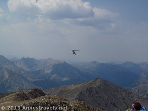
A helicopter circles near the summit of Mount Elbert
While we’re on the topic of State High Points, let’s go for one more: and this one has some real claims to fame! At 14,440 feet (4,401m) above sea level, Mt. Elbert holds the record for the highest peak in Colorado as well as the status of second highest peak in the continental US (after Mt. Whitney in California). This said, the trail turned out to be easier than I expected after having climbed Greys Peak a few years ago. That’s not to say that the South Mount Elbert Trail is easy, but we found it doable on a beautiful day last week (August 2013). If you have high clearance, the trail is only about 8 miles RT (12 km) (officially), and the views from the climb and the top are stunning – so much nicer than from Greys Peak!
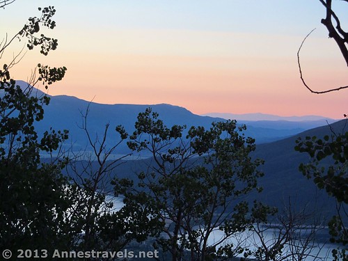
The sunrise over the Twin Lakes
We had learned a lot from our Greys experience, not the least of which was that we needed to start early – very early – to avoid the afternoon thunder showers. So, we drove down the dirt road the day before, opting to stay in the one camp site between the middle parking area and the trailhead (upper parking area). (If this site is taken (and it’s a very nice site), I doubt anyone would mind if you parked/camped in the middle or upper parking areas…the middle one even has a fire ring!) We stuffed the packs, set the alarms on watches before going to sleep, and settled down for a peaceful night sleep. The next morning, the alarms went off as planned (even if none of us heard one of them!), and we were on the trail by 5:40am. We live on Eastern Time even when we’re traveling (for daylight reasons – it’s great to get up with the sun), so this was only 7:40am, an adjustment I’m sure we all appreciated! It was still dark, but light enough to hike up the road to the trailhead and then get on the right trail.
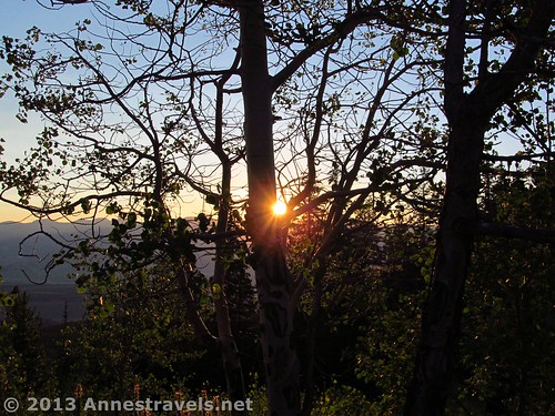
The sun rises over the mountains
The South Mount Elbert Trail begins by crossing a footbridge next the signboards. It then makes a sharp right turn to follow the creek for about 0.1 miles (0.2 km) to the first trail junction. Turn left here; going right (straight) would take you the wrong way on the Continental Divide Trail. The junction is well-marked. Walk another 0.3 miles (0.5 km), then turn left at another trail junction to leave the Colorado Trail and the Continental Divide Trail behind. Up to this point, the trail has been mostly flat with very little elevation gain or loss. As soon as you turn onto the South Mount Elbert Trail, however, the trail begins to gain elevation in earnest. This is probably the steepest section of the entire trail; it’s also very rocky, gravelly, and slippery – I’m sure it’s intentional to turn off those who can’t make it the rest of the way. Keep at it, though, as the trail will improve dramatically within the next half mile (1 km) or so.
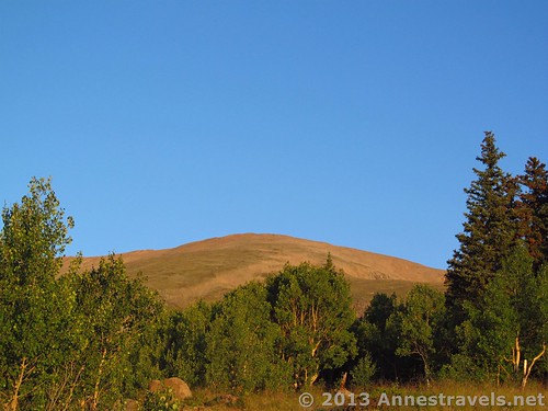
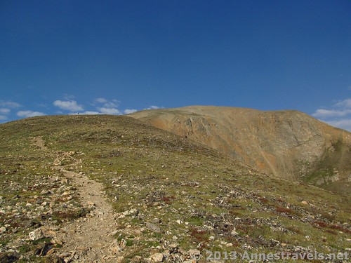
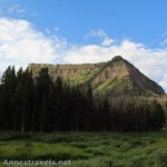
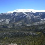
Early view of Mount Elbert – this is actually the false summit; the real summit behind the false one
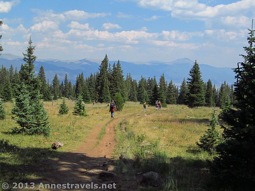
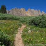
The trail climbs steadily through an aspen forest before emerging into an alpine meadow. Along the way, peek-a-boo views of the Twin Lakes and the ridge near Mt. Elbert are visible through the trees. Here, Mt. Elbert is not the ridge to your left; it is currently out of sight ahead of you. Your first good view of Mt. Elbert is on a social trail near mile 1.8 (2.9 km). The trail through the meadow is considerably less steep, but the trail continues to climb. If there’s one thing that the builders of the trail did right, it was that it doesn’t waste time losing elevation only to gain it again. Although the steepness varies, the trail is always, always climbing. I suppose this is how the trail climbs nearly 4,000ft.(1,300m) in less than 4 miles (6.4 km)!
Near the treeline (this picture was taken on the way back down)
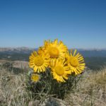
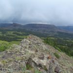
After a short stint in a fir forest, the trail rises above the treeline and into tundra-like meadows. Now the views begin to open up around you. Keep looking back at the Twin Lakes; Leadville will also become visible. There are also wildflowers in the meadow at various points depending on the time of year. Last week, many of the flowers were beyond their prime, but a few remained (especially higher on the trail).
At about 2.8 miles (4.5 km), the trail enters a saddle. Near this saddle, atop a hill of stones, is an American flag – we didn’t investigate, but apparently this is a popular place to rest/turn around/look around. It certainly is a nice place to take in the view. Here is where you get your first view of the mountains on the north side of Mt. Elbert (well worth seeing – you’ll get the best view later), as well as awesome views of the surrounding countryside. It’s quite pretty; the video below was taken just below this saddle.
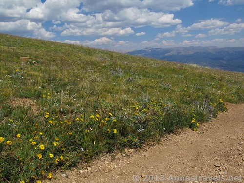
Wildflowers along the trail
After a short snack we began the next phase of the ascent. From here, the trail is less dirt and more rocky; it’s not steep as in the beginning, but it climbs relentlessly. This was where we began to meet people who’d started very early so as to be off the peak well before noon. One group we met had gotten up at 3am and hiked from the lower parking area (which adds 2 miles (3.2 km) OW to the trek) – I appreciated their determination to do it right, but was also glad we didn’t have to do that!
The last 2 miles (3.2 km) before the top are the killer section, and the section where we saw the most people turning around. Not only is it relentless in its climb, the air gets considerably thinner and thinner. I’d expected to have altitude issues, like I did on top of Greys Peak (mostly the inability to think), but except for being a bit out of breath and some pressure in my sinuses, it wasn’t bad at all. Even the youngest members of my party, who usually have altitude issues, were ok. That was a blessing! Even so, we had a wonderful time trying to do simple math problems – with hilarious results (“What’s 9+9?” “19!”, etc.).
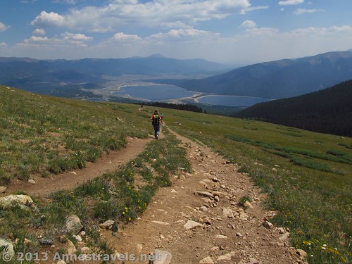
Looking back at the Twin Lakes
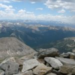
Then, finally, when it seems you must have been climbing forever, you suddenly summit the ridge – really a small saddle just below the peak and the junction with the North Mount Elbert Trail. My first impression of summiting the ridge was, “Wow!!!” Spread out below is a spectacular view of mountain range upon mountain range, peak upon peak, mountain valley upon mountain valley. Earlier in the season this would be stunning with snow-flecked mountains, but even in August it took my breath away. A small mound to the right gives you and even better view. Reinvigorated by the view, it was a simple push up the trail to the left of the saddle to the peak of Mt. Elbert, itself.
This end of the peak has several wind shelters; keep going until you reach the highest point which is marked by a pile of stones with a stick stuck into the middle (there is a wind shelter here, as well). Congratulations! You made it to the highest point in Colorado! The videos below were taken from the summit – the first is a better over-all view, but the second has more sunshine on the mountains.
Hiking upward
The view from here is also very rewarding. You can see everything you saw from both saddles and more. It was wonderful to just stand and look at the view and snap some pictures to prove we’d been there. We finally decided we’d better head back down since the weather looked like it could turn threatening and it was already after noon (all the real hikers were leaving the peak just about the time we arrived, while the more amateur hikers mostly arrived about the same time we did). The trail down was a bit easier because we didn’t have to keep stopping for breath, but it is steep so it took us more time than it might have. We arrived back at the trailhead 10 hours after leaving…in time to unpack, make supper, and enjoy a well-deserved rest before heading off to our sleeping bags.
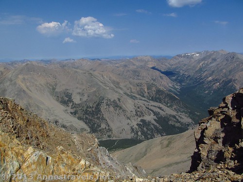
View from the saddle just below the peak
Bottom Line: The South Mount Elbert Trail isn’t for everyone, especially if you’ve never hiked a 14er before and don’t know what to expect/aren’t used to hiking long distances. However, if you have high clearance, I highly recommend the South Mount Elbert Trail over the North Mount Elbert Trail because the North Trail is far steeper than the South Trail as well as being 2 miles (3.2 km) longer (RT; approximately). If you’ve done other 14ers, know what to expect, and are looking for spectacular views, I highly recommend this trail.
Round Trip Trail Length: Officially 7.4 miles (12 km) from the trailhead; my GPS read 9.3 miles (15 km)
Net Elevation Gain: Officially 3,915 feet (1,193m); my GPS read 3,858 feet (1,175m)
Facilities: Signboards at the trailhead. Otherwise, none. By the way, I highly recommend that if you need to find a “private bush” you do so in the pine forest before reaching the treeline. After this, there is nowhere reasonable to “go”.
Fees: None
Trail 
Road
Signs
Scenery
Would I go 100 miles out of my way for this?
Overall Rating:
Key GPS Coordinates for the South Mount Elbert Trail:
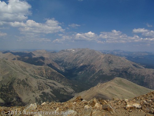
View from the top
Mount Elbert Parking 1 (on paved road): 39.099092N / 106.367135W (39° 5′ 56.7306″N / 106° 22′ 1.686″W) (unsure of elevation)
Mount Elbert Parking 2 (before roughest road; about ¼ mile (0.4 km) from trailhead): 39.10399N / 106.39439W (39° 6′ 14.364″N / 106° 23′ 39.804″ W) (10,479ft; 3,193m)
Mount Elbert Trailhead (parking nearby): 39.10561N / 106.39539W (39° 6′ 20.1954″N / 106° 23′ 43.404″W) (10,564ft; 3,220m)
Mount Elbert/Continental Divide Trail/Colorado Trail Junction 1: 39.10602N / 106.39506W 39° 6′ 21.672″N / 106° 23′ 42.216″W) (10,353ft; 3,155m)
Mount Elbert/Continental Divide Trail/Colorado Trail Junction 2: 39.10948N / 106.439397W (39° 6′ 34.1274″N / 106° 26′ 21.8286″W) (10,420ft; 3,176m)
View of Mount Elbert 1: 39.11124N / 106.40077W (11,183ft; 3,408m)
First Saddle (just before the mound with the flag): 39.12073N / 106.41924W (39° 7′ 14.628″N / 106° 25′ 9.264″W) (12,441ft; 3,792m)
The great view near where the North and South Elbert Trails merge: 39.11828N / 106.44456W (39° 7′ 5.8074″N / 106° 26′ 40.4154″W) (14,377ft; 4,382m)
Mount Elbert Peak: 39.11775N / 106.44538W (39° 7′ 3.9″N / 106° 26′ 43.368″W) (14,422ft; 4,395)
The gpx file for Mount Elbert can be downloaded – please note that this is for reference only and should not be used as a sole resource when hiking this trail.
Download GPS File File size: 261.5 KB Downloaded 335 times
(Note: I do my best to ensure that all downloads, the webpage, etc. are virus-free and accurate; however, I cannot be held responsible for any damage that might result, including but not limited to loss of data, damages to hardware, harm to users, from use of files, information, etc. from this website. Thanks!)
Getting to the South Mount Elbert Trailhead:
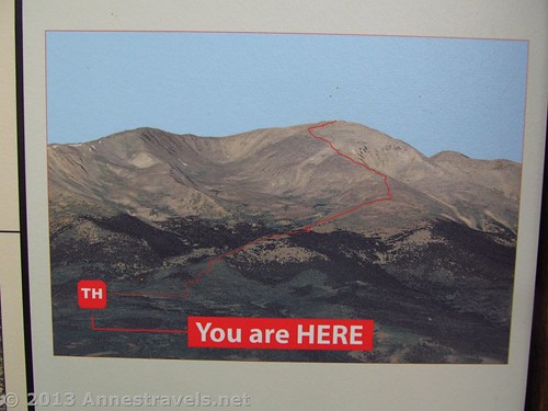
Map on a picture of the South Mount Elbert Trail – this photo was at the trailhead
From Leadville, drive south on US-24 out of town. At 12.8 miles (20.5 km) past the airport, turn right on CO-82 West. Drive 4 miles (6.4 km), turn right on County Road 24 (not to be confused with US-24); the Twin Lakes will be on your left as you make this turn. County Road 24 is about 2.5 miles (4 km) east of the town of Twin Lakes (if you’re coming in from the Aspen area). Drive 1.3 miles (2 km) up County Road 24, past the Lakeview Campground (operated by the Forest Service). Just beyond the campground is the South Elbert Trailhead – this is Parking Area 1, accessible to nearly all vehicles (exceedingly long vehicles may have slight trouble getting up County Road 24, but could likely do it ok).
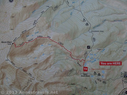
Topo Map of the South Mount Elbert Trail – courtesy of the signboard at the trailhead
Directly after South Elbert Trailhead, a dirt road goes off on the left (I believe this road is named Forest Road 125; it is signed as FSR 125.1B). A sign slightly down the road says that the Mount Elbert Trailhead is in 2 miles, but that this is a 4×4 road. However, if you have high clearance, you can drive this road for about 2 miles (3.2 km) to a second parking area; 4×4 vehicles can go ¼ mile (0.4 km) further to the trailhead and third parking area. The dirt road was in fairly good condition, though a bit rutted in places, when we drove it, which is why I only recommend it to high clearance vehicles. It is mostly only 1 lane wide, so if you’re driving it and come upon another vehicle, one of the two of you will need to back up to a wide section in the road/campsite/something so you can pass.
Extremely important note!!! After nearly 2 miles (3.2 km), the road will split in a wide area. You must either park here (and walk ¼ mile (0.4 km) up to the trailhead) or turn right and drive the very rough road to the trailhead. Do not go left!!! We tried this; there is nowhere to turn around and you’ll have to back down a very steep, extremely narrow jeep trail. We broke a mirror trying; a truck we saw came through with a serious dent in his bumper from the very same tree. So, do yourself a favor and turn right/park instead of checking out the left fork in the road.
This Week’s Featured Product!
There are a total of 53 14ers in Colorado (with at least 300ft (90m) geographical prominence). That’s a lot of peaks! In this well-enjoyed book, the authors cover the trails/routes to each summit as well as alternative routes, route descriptions, topographical maps, GPS coordinates, and more.
Pingback: Anne's Travels » Electric Pass: The Highest Named Pass in Colorado
Pingback: Anne's Travels » Chasm View Trail – Short Trail, Wonderful Views!
Pingback: A Hike from Independence Pass to UN 12812 - Spectacular!
Pingback: 12 Epic Hikes in the Western US, Pt. 2 - Anne's Travels
Pingback: Celebrating 20 Years of Family Vacation - Anne's Travels
Pingback: Sunrise on Mt. Hood at the Cloud Cap Inn - Anne's Travels
Pingback: Link Roundup: My Favorite Hiking Websites - Anne's Travels
Pingback: 11 of the Best Dayhikes for Mountain Views of Colorado - Anne's Travels
Of the seven states that border Colorado, which one can you not see from the highest point in Colorado, which I believe is Mount Elbert? It’s a trivia question that somebody asked back here in Ohio.
As far as I know, the only state you can see from Mt. Elbert is Colorado. So you’ll have to let us in on the answer!