

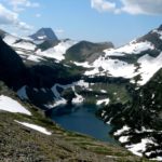
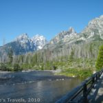
St Mary’s Lake and Glacier
Not far from I-70 near Idaho Springs in Colorado lies a small lake. That’s nothing terrifically exciting, as Colorado has lots of small lakes, but the exciting thing about this destination is the glacier that rises above the lake. St. Mary’s Glacier holds the title of the US’s southernmost glacier, and well into June determined skiers come to have a free ride down the glacier’s, well, sometimes mushy, surface. The trail is also a popular destination for locals to run their dogs, as well as a weekend retreat for couples, families, and even family reunions.
To get to the parking area for St. Mary’s Lake and Glacier, take I-70 to the exit for Fall River Road. I believe that the exit number is 238. Just past the bottom of the exit ramp, go north (right if you’re coming from Denver) and follow the road up to the town of Alice. There is only one parking area for the trailhead, and it has a small parking fee ($5). There are very clear signs along the road that you must not park anywhere but in the parking area, but after the parking area filled up, everyone parked along the side of the road, and no one appeared to care (I’m not suggesting you try this, but all the locals do it when there’s nowhere else to park…!) The parking fee is good through the night, so we considered staying there since we had paid for our parking, but we didn’t end up doing it because we wanted to get elsewhere. The trailhead is back up the road from the way you came. It looks like an old, rocky road.

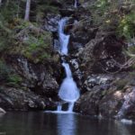
The view near the “quiet spot for lunch”
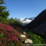
The trail starts out quite steep and very rocky. I think that at one time it must have been a 4×4 road, but it is now closed to vehicles. At a few points it is uncertain which way the trail goes, as the road forks in different directions, but it should be pretty obvious which way to go, as if you take the wrong trail it will soon peter out. Keep going uphill for about a mile until you come out near the stream that flows from the lake. A bridge crosses the stream, and the trail continues along the lake. However, if you’re just looking for a pretty view and a nice spot to eat lunch, I suggest not crossing the bridge, and going left along the lakeshore. Pretty soon any crowd disappears, and you’ve got the area to yourself.
Speaking of crowds, I don’t recommend doing this on a weekend. We were there on Sunday, and it was extremely crowded, especially in the afternoon. A few people had spent the night, and a few more had gotten an early start, so we didn’t realize what a popular destination this was until we came back down from our hike up the glacier around noon. Yikes! What a change! People everywhere, and the trail so crowded it’s no wonder it looks like it’s a road. So, my advice is to go on a weekday or get an early start to avoid the crowds.
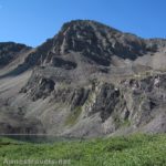
Back to the glacier: Keep following the trail past the sign that says you are entering a national forest and all of the rules and regs about what you can and can’t do. You will eventually come to the toe of the glacier, but how far it is will depend on the time of year and how much of the glacier has melted. When we were there, people could still ski, but one of the locals said that usually at that time of year you couldn’t even get to the glacier easily, but that the entire rock face became a series of waterfalls and wildflowers. It sounded very pretty, but I’m just as glad that we were able to climb the glacier.

A skier on the glacier
If you’ve ever been to the Columbia Ice Fields in the Canadian Rockies, you’re in for a shock with this glacier. First of all, there are no crevasses. Second, at least in June, it’s not half as big. So don’t think you’re in for a true glacial experience; just realize that you’re more going to be seeing a large permanent ice field than a glacier.
We started climbing up the snow. It’s quite the hike just because the snow is slippery and can be hard to climb. Still, with some perseverance it’s not too difficult. About halfway up we stopped to talk to a skier. He’s actually a native of Vermont, but since he moved to Colorado several years ago he’s skied here every month, except for 2 a few years ago when he didn’t get up here. He also proudly told us that the skiing here today was better than any skiing he ever did in Vermont, except for perhaps one day when it was unusually snowy and cold. I wouldn’t have thought the slushy surface would have been that good for skiing, but, hey, if it’s better than Vermont, it must be good!
Several skiers passed us, some hiking up carrying their skies and some skiing down. There were also teens snowboarding. I also gather that children sled down the glacier in the winter, but this is very dangerous because they have no way to stop, so there are quite a few accidents when sleds get out of control and run into the rocks on the edge of the glacier. A sign up on the hillside memorializes some of them.
From the lake, the glacier doesn’t look very tall, but once you start climbing you can see that it’s actually about twice as tall as you can see from the lake. We finally got to the top 1-2 hours after we started climbing. There were trails up there that looked like they might have very nice mountain views, but we decided that we’d better not explore them right then, as some of our group had decided to stay at the bottom, and we hadn’t brought anything to eat with us. (Somehow we always regret it when we don’t bring food with us “because this is a short hike and we’ll be back before lunchtime”: we’ve done it so many times that when we pull into an overlook we joke, “Better bring lunch—never know how long we’ll stay at the viewpoint!”) Also, a couple of the members who were with us weren’t happy that they hadn’t been invited not to climb the glacier (sliding down definitely made up the difference for them, though). So, we thought it better to turn around and go down.

From the top of the glacier
Going down was definitely exciting, though not for the unsteady on their feet. We ran, slid, jumped, and held the hands of the little ones so they wouldn’t fall. That didn’t keep us from falling—I managed to scrape my knee on the snow, and several of us nearly took nose-dives—but we had a glorious time. Even the adults loved it, especially watching the children slide across the snow.
Return by the way you came. We went over to the place across the bridge that I mentioned earlier and ate lunch (the part of our group who had stayed below had gone back to our vehicle and gotten lunch—a wonderful thing for them to do!) There, we were entertained by the members of a family reunion who jumped off a high rock into the lake. One person even climbed up the top of another glacier and skied down into the lake itself. Totally crazy if you ask me, but I suppose some people like it!
Trail 
Road
Signs
Scenery
Overall Rating:
This Week’s Featured Product!
Explore the very best views in Colorado, from easy strolls to all-day hikes.
Great article, it sounds like a wonderful place! I hope I can get there sometime soon. But I have to point out that this is not the most southerly glacier in the US. St. Mary’s glacier is at 38.9 degrees N, and the Palisade glacier in the eastern Sierra is at 37.1 degrees N. That glacier isn’t nearly as easy to get to, though, and doesn’t get many visitors.
Joel, I agree, I wouldn’t think this was the most southerly glacier… in fact, I’d call St. Mary’s a very large permanent snowfield! I visited a glacier in Nevada that claims the same title, and I think that may be more accurate.