

The trail in the Swiftcurrent Amphitheater
The most spectacular hike in Glacier National Park – and the most spectacular I’ve ever taken from Many Glacier – might very well be the hike up to the Swiftcurrent Lookout. The path passes three beautiful alpine lakes, a very nice waterfall, and mountain views innumerable before arriving at a rock amphitheater with waterfalls tumbling down its craggy sides. The path then rises upward past the waterfalls, with views spreading across the Many Glacier Valley, up to Swiftcurrent Pass. While the pass itself isn’t all that exciting, taking the steep path up to the Swiftcurrent Lookout is literally breathtaking, not only because of the path but also because the views open up across most of Glacier National Park. It’s beyond spectacular to downright jaw-dropping.
Quick Stats

The lower part of Red Rock Falls
If I’ve just sold you on taking the hike, here’s the problem: The entire path is approximately 17.6 miles RT. And there are basically no backcountry campsites along the route. So you’ll have to be in top-notch shape before attempting this as a day hike. In fact, only half of my group did the entire hike.

The part of the group that didn’t do the entire hike did see a mother and baby moose!
But if you’re not feeling like a 17 mile trek with 4,300 feet of elevation gain – in fact, if you’re just looking for an extremely pleasant, extremely beautiful, and quite a spectacular day hike – you can end your hike in the rocky Swiftcurrent Amphitheater for an 8.6 mile out & back hike. The trail is pleasantly flat up to the Amphitheater, so you won’t even have to worry about a ton of elevation gain!
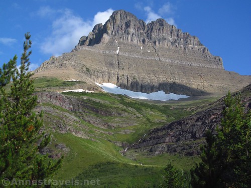
Mt. Wilber stands guard over the trail just below the Amphitheater
So I’ll detail the day hike to the Swiftcurrent Amphitheater in this post (since it’s a perfectly viable and alluring hike in its own right) and then next week I’ll talk about the hike up to Swiftcurrent Lookout.

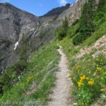
The trail above Red Rock Falls
The trailhead is at the far end of the parking area for the Swiftcurrent Motor Inn. It’s prominently signed for Swiftcurrent Pass. If in doubt at any trail junction (there aren’t many), follow the signs for Swiftcurrent Pass.

Moose along the trail
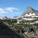
After 200ft., the trail splits right toward Iceberg Lake and left toward the campground; continue straight on the Swiftcurrent Pass Trail. About 0.25 miles from the trailhead, a very unique tree does a U before shooting upward again. All of us knew we’d seen the tree on our second-to-last visit to Glacier National Park 15 years earlier, so we were ecstatic to find it again. About 0.3 miles from the trailhead, a trail on left goes down to Fishercap Lake. I’ve heard that it’s beautiful, but I didn’t take the time to go down to the lake. After the junction, views begin to open up to the peaks surrounding the valley, especially Mount Grinnell to the left, Mount Wilber to the right, and Swiftcurrent Mountain at the head of the valley. Beautiful!

Views of the valley and mountains above Fishercap Lake
About 1.3 miles beyond the spur down to Fishercap Lake, the trail touches the shore of Redcap Lake. The views across the lake are quite good.

Redcap Lake
Continue another 0.3 miles to the head of the lake and various junctions on the left that lead to Redrock Falls. This is a very worthy side-trek if you have the time and energy. The falls has several tiers with real and social paths between them. You might find yourself scrambling in places, so watch your step on the wet/slippery rocks!
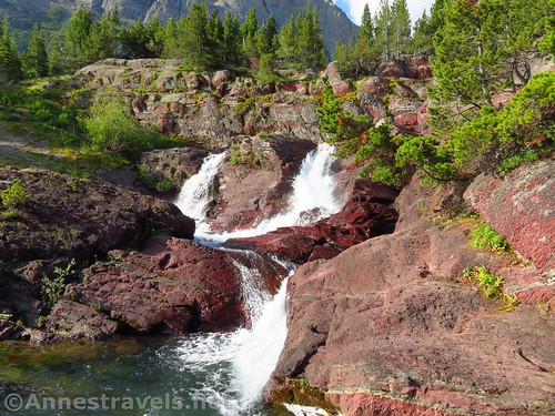
The upper cascades of Red Rock Falls
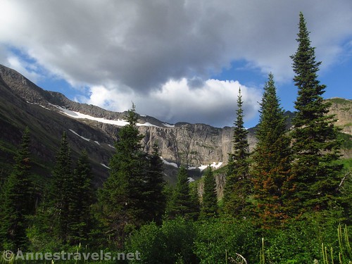
We returned to the trail and continued upward. The path passes through stands of trees, meadows, a swinging bridge, and views to various mountains (so beautiful!) over the next mile or so to Bullhead Lake. This is the prettiest of the lakes to date, per me.
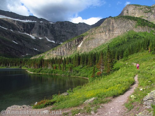
Walking along Bullhead Lake
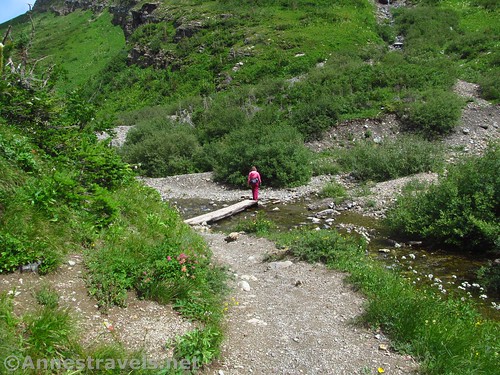
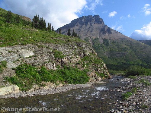
The trail winds along Bullhead Lake, crosses the head of the lake, and turns up the inlet stream. About a half mile from the end of the lake the path turns suddenly to cross the stream via a wooden bridge. Immediately after this, the trail begins to rise up the side of the canyon via steep switchbacks. This is the Amphitheater.

Swiftcurrent Falls in the Amphitheater
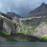
Half of my group stopped at the bridge. And it’s no wonder they felt they’d gotten their trails-worth in terms of views. Besides all the mountain-peak and lake views along the trail, the Amphitheater, with its waterfalls tumbling down the cliffs, vibrant green lower slopes, rocky peaks above the cirques, and the Swiftcurrent Glacier high up on the center and left part of the cliffs, is truly a place you can just look at for half of forever.
Looking back at the bridge across Swiftcurrent Creek that marks where the trail begins ascending
The rest of us began the trek upward. And if views are your thing, definitely continue upward for even a short distance. The views as you rise up the side of the Amphitheater are even better than the views by the bridge. You can reach a beautiful unnamed falls (I’ll call it Swiftcurrent Falls, because, why not?) after 0.7 miles, then come to a scary curve where the trail was hewn out of the rock 1 mile from the bridge. This curve offers some truly impressive views back down on the Many Glacier valley. But only do these if you’re feeling energetic; those switchbacks are calf-busters!

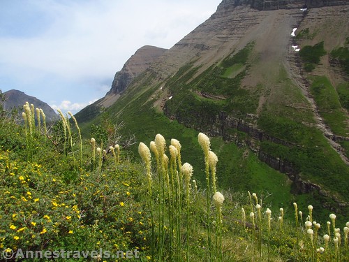
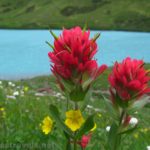
Beargrass and other wildflowers in the Swiftcurrent Amphitheater
And be on the lookout next week for Part 2 of the hike – all the way up to Swiftcurrent Pass and the Swiftcurrent Lookout!
Hiking higher up in the Amphitheater
Round Trip Trail Length: 8.6 miles to the Amphitheater and back. 0.7 miles RT to Fishercap Lake; 3.2 miles RT to Redrock Lake; 4 miles RT to Redrock Falls
Net Elevation Gain: 331ft. (4,940ft. to 5,271ft.)
Facilities: Snack shop, campground, restrooms (in the campground), cabins, and visitor center located at or within walking distance of the trailhead.
Fees: $35/vehicle/week. National Park & Federal Recreational Lands Passes and Glacier Annual Passes are honored.
Trail Notes: Despite the length of the hike, it’s not as hard as it sounds because much of the trail is flat. If you are going up to the lookout, make time on the flat sections; not all of the hike is as smooth as this part. You’ll lose most of the crowds after Redrock Falls, so some of the trail is more solitary than might be expected.
Storm clouds gather over the Amphitheater and the Swiftcurrent Glacier
Trail 
Road
Signs
Scenery
Would I go 100 miles out of my way for this?
Overall Rating:

Heading back down the trail just below the bridge
GPS Coordinates for the Swiftcurrent Amphitheater
Trailhead: 48.7977500°, -113.6786167° (N48° 47.865′ W113° 40.717′ / 48°47’51.9000″, -113°40’43.0200″) (4,940ft.) (0.0)
End: 48.7977000°, -113.6785167° (N48° 47.862′ W113° 40.711′ / 48°47’51.7200″, -113°40’42.6600″) (4,945ft.) (17.61)
Trail junction: 48.7979333°, -113.6791667° (N48° 47.876′ W113° 40.750′ / 48°47’52.5600″, -113°40’45.0000″) (4,948ft.) (200ft.)
Fishercap Lake Junction: 48.7987667°, -113.6837333° (N48° 47.926′ W113° 41.024′ / 48°47’55.5600″, -113°41’01.4400″) (4,946ft.) (0.32)

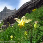
Meadows above Red Rock Falls
Rockrock Lake: 48.7975333°, -113.7077833° (N48° 47.852′ W113° 42.467′ / 48°47’51.1200″, -113°42’28.0200″) (5,029ft.) (1.62)
Redrock Falls Junction: 48.7955167°, -113.7113000° (N48° 47.731′ W113° 42.678′ / 48°47’43.8600″, -113°42’40.6800″) (5,070ft.) (1.91)
Redrock Falls: 48.7951500°, -113.7108500° (N48° 47.709′ W113° 42.651′ / 48°47’42.5400″, -113°42’39.0600″) (5,054ft.) (1.96)

Looking down on Red Rock Falls
Regain trail: 48.7951500°, -113.7115333° (N48° 47.709′ W113° 42.692′ / 48°47’42.5400″, -113°42’41.5200″) (5,080ft.) (2.02)
Far end of Bullhead Lake: 48.7858000°, -113.7409000° (N48° 47.148′ W113° 44.454′ / 48°47’08.8800″, -113°44’27.2400″) (5,188ft.) (3.80)
Amphitheatre: 48.7802333°, -113.7432833° (N48° 46.814′ W113° 44.597′ / 48°46’48.8400″, -113°44’35.8200″) (5,271ft.) (4.33) (return 13.41)
Looking downstream from the bridge in the Amphitheater
The gpx file for the Swiftcurrent Amphitheater and Swiftcurrent Lookout can be downloaded – please note that this and the GPS Coordinates are for reference only and should not be used as a sole resource when hiking this trail.
Download GPX File size: 385.1 KB Downloaded 93 times
(Note: I do my best to ensure that all downloads, the webpage, etc. are virus-free and accurate; however, I cannot be held responsible for any damage that might result, including but not limited to loss of data, damages to hardware, harm to users, from use of files, information, etc. from this website. Thanks!)

The swinging bridge on the Swiftcurrent Pass Trail
Getting to the Swiftcurrent Trailhead
From St. Mary, drive north on US-89N for 8.5 miles. Turn left in Babb, following signs for Many Glacier. After 7.5 miles, enter Glacier National Park and the road will improve. Drive another 4.8 miles to the end of the road by the Swiftcurrent Motor Inn (which is actually a gift shop). The parking area is large but usually fills up by 10am or noon during the summer season (weekdays and weekend days similarly).

The path along Bullhead Lake
From the north, drive about 10 miles south of the Canadian border to the town of Babb. Turn right, following the sign for Many Glacier, and follow the directions above to the trailhead.
Early morning shadows at Red Rock Falls
Road note: As of summer 2019, the road to Many Glacier is one of the worst I’ve seen as a thoroughfare into a national park. It’s literally riddled with potholes. So slow down and use care; the people around you will be swerving to try and avoid the gaping holes in the road.

Visual trail map of the Swiftcurrent Pass Trail from the TH to the Swiftcurrent Amphitheater – the elevation profile is for the trail all the way up to Swiftcurrent Peak; this section of the trail is the flat part of the profile
Zoom map out to browse nearby hikes & places of interest
This Week’s Featured Product!
For a book about hiking in Glacier National Park written by someone who knows the trails well, check out this one. It details 40 trails (most in the American half of the park, with a couple in Waterton Lakes) for various skill levels, interests, and more.

Pingback: Sneak Peak: The Beauty of Western Montana! - Anne's Travels
Pingback: Swiftcurrent Lookout - So Long a Hike, So Worth It! - Anne's Travels