

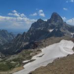
Grand Tetons from Table Mountain
In the last post, I talked about taking the Face Trail up to Table Mountain, right on the edge of Grand Teton National Park. The views from the top are beautiful; some of the best views of the Tetons I’ve ever seen. However, there are two trails to the top—one that’s 7 miles round trip (the Face Trail) and steeper, and other that’s 11 miles round trip (the Huckleberry Trail) and only slightly less steep. We took the Face Trail up and the Huckleberry Trail down (a popular way to do the hike), but I’m not sure I’d do it that way again: the Huckleberry Trail is still very steep, so I don’t personally think the extra 2 miles are worth it. However, I’ll write about it, first telling you how to get to the trailhead, then taking you down the trail from Table Mountain like I did it. (Update: A few years later, I did take the Face Trail up and down; you can read about that here.)

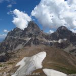
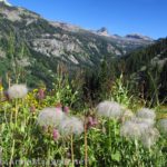
Wildflowers along the Huckleberry Trail
To get to the parking area for the Huckleberry Trail, from the town of Driggs, Idaho (along Rt. 33), turn east at the stoplight onto East Ski Hill Road (also known as East Little Avenue). This is a left turn if you’re coming from the north (Yellowstone, etc.), a right turn if you’re coming from the south (Jackson Hole). Key Bank and Southby’s will be on the corners of this turn. Drive 6.6 miles, then turn right on Teton Canyon Road. Drive on this road for 4.5 miles—the road is quite passible by passenger cars (I saw a smart car do it), but it has quite a bit of washboard, so we couldn’t get over about 20 mph. You’ll pass a couple of campgrounds and a Boy Scout Camp before you reach the parking area for the Huckleberry Trail. There is another campground right across the parking area if you want to stay in it ($10/night; there are also multiple “backcountry” camping pull-offs along the road if you prefer solitude). The parking area has primitive restrooms, water, and a garbage canister.

Looking south from the mountaintop
First, let me explain that this is a must-do hike. If you like nice views, this is one of the nicest in the area; better than almost any trail I’ve done in Yellowstone or the main area of Grand Teton National Park. The views from the trail and the top of Table Mountain are simply sublime; beautiful beyond words. You can read more about it in my last post; I’ve linked again to a video I took at the top. I think you get slightly better views—at least in the morning—from the Face Trail, although there are also nice views on the Huckleberry Trail (especially after you’ve gained some elevation). The choice of which trail to take is really up to you—I enjoyed climbing up the Face Trail, but one scramble down to take a picture was enough to convince me it wouldn’t be easy to hike down. Still, the Huckleberry Trail is longer and, in my opinion, not enough less-steep to warrant the extra two or four miles (round trip). Take you pick; I’ll try not to be too biased, but you know where I stand.

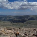
The view to the north from Table Mountain
After you’ve enjoyed the view from the top of the mountain, scramble back down from the summit block and back down the gravely path that descends the mountain. You will cross one rock field with cairns marking the trail. Then you will descend through meadows to a trail junction. When I was there, rocks and logs had been placed over the entrance to the left trail; this is the Face Trail (which I came up). However, if you want to go down the Huckleberry Trail, keep going straight (right). The trail is fairly flat for a short ways; then you realize that you will be hiking down a series of steep, winding switchbacks. At the beginning of the first switchback is a sign telling you not to cut switchbacks—it’s an odd place for the sign, but it actually marks the horse trail over the top instead of along the side of the mountain—the two connect at the end of the first switchback. I can understand why horses wouldn’t want to do the first switchback—it’s extremely narrow, with a cliff up on one side and a cliff down on the other side. It’s wide enough for hikers, but not for horses.

Coming down off of Table Mountain
The trail switchbacks its way down into the valley through a steep meadow that, at least in mid-July, was full of wild flowers. You’ll likely cross numerous little streams; none of these are difficult to cross. The time of year, snowfall the winter before, and how recently it rained will determine the exact number of stream crossings. After a light snow year and not-too-recent rain, there were some flowing and others were just damp patches. At the bottom of the switchbacks, the trail enters the forest. This is nice on a hot afternoon; the meadow is extremely exposed. For the next few miles, the trail will follow the stream, mostly through the forest. Along the way, you’ll cross the stream four times—without bridges. Each crossing has stones and/or logs so you can cross without getting your feet wet; these may be lacking or under water early in the season. In mid-July, we had very little trouble crossing the streams (even the members of my group who say they aren’t good with log bridges and stepping stones).

Descending the switchbacks
The trail eventually leaves the stream, and begins to meander downward through forests and meadows. The trails in the meadows I found very dusty. As you’re descending, keep looking back—you can see Table Mountain for quite a ways, and the rocky canyon walls are majestic-looking. The trail is rarely flat; sometimes it’s steep and sometimes it’s not quite so steep, but it keeps going downhill almost the entire way. Before you reach the bottom, you’ll encounter a sign pointing to the horse camp; keep going straight. This trail, rather than the Face Trail, is better known, and more likely to have hikers on it. Still, it was amazingly not crowded on a Sunday, and most of the people we met were locals. It’s strange that this trail isn’t better known, considering the beauty of the views.

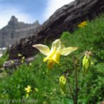
A peek-a-boo view from the forest
And then, 5.5 miles from the top of the mountain and 4.25 miles since you left the Face Trail junction, you’ll arrive at the parking area. If you parked at the Face Trail (Alaska Basin) parking area, turn left and hike the 1/10 mile back up to the end of the road and your vehicle. It doesn’t matter which trail you take in the end; just hike it…you won’t be disappointed!
Trail 
Road
Signs
Scenery
Would I go 100 miles out of my way for this?
Overall Rating:
This Week’s Featured Product!
If you like to visit the out-of-the-way (but very beautiful) hikes of Wyoming, check out my book about day hiking Wyoming!

I am extremely impressed with your writing skills as well as with the layout on your blog. Is this a paid theme or did you customize it yourself? Either way keep up the excellent quality writing, it is rare to see a nice blog like this one today
Hi Yoko,
I customized the theme from a WordPress template.
Thanks,
Anne
Pingback: Unknown
I simply want to say I am just beginner to blogging and site-building and definitely loved your web blog. I’m likely to bookmark your website . You really come with remarkable well written articles. Thank you for sharing with us your blog site.
A word of thanks for the author.The art of writing the content is fantastic. I need to appreciate your knowledge about that subject.
This is simply not only one of your reports I’ve look at, and you just never cease to impress me personally. Warm regards, and i also look ahead to discovering your future posts.
I am excited to see so different helpful information at this point, we should develop more strategies in this regard.
Is there another trail besides the face and huckleberry? I hiked table rock about 15 years ago, then just this last week I hiked it again, going up the face and down huckleberry. I remember going a different way, I thought it was to the right of the face trail head. Do you know? I may not be remembering correctly so could you clarify for me. Thank you.
Unseasoned Hiker,
Those are the only two trails I know of, although I’ve read that you can get over to the Alaska Basin area from the peak. I thought about it and decided it was too long, especially as an overland trail, for that day.
Anne
Pingback: Table Mountain, Grand Teton National Park
Pingback: Table Mountain – Up and Down the Face Trail - Anne's Travels
Pingback: Alternate Views of Famous American Wilderness Areas
Pingback: 12 Best Day Hikes in Grand Teton National Park - Anne's Travels
Pingback: The Glory of the Lord Covers the Earth - Anne's Travels