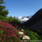
The view from Twisp Pass
On a recent trip to Washington State, we were longing for a glimpse of some real, honest-to-goodness North Cascade scenery. Unfortunately, the Cascades, including North Cascade National Park, were still snowed in, due to heavy snowfall and cool summer temperatures. Finally, after a few days of hiking in the less-snowy eastern part of the state, we found a hike that would take us deeper into the Cascade Range without getting ourselves into deep snow: Twisp Pass, on the very edge of North Cascades National Park. The hike itself was 9 miles round trip, and wound its way through some of the most classic Cascade scenery we saw on the trip. Although the pass itself was somewhat wooded (and thus didn’t offer much of a view), the trail leading up to the pass was spectacular, as was a little viewing area we discovered to one side of the pass. You are looking into the heart of North Cascades National Park, with only a mountain lake separating you from the mountains. It was a very nice change of pace from what we’d seen in the more arid, less mountainous part of Washington!
The parking area for Twisp Pass is located in the Okanogan National Forest/Lake Chelan-Sawtooth Wilderness, so you will have to pay for a $5 per day Northwest Forest Service Pass to park in the area. You will actually be hiking through the National Forest up to the National Park boundary, which is at the pass. To get to the parking area, from the town of Twisp turn onto Twisp River Road West (that’s left if you’re coming from the south, and right if you’re coming from the north). This turn is the second left after the library/community center (a Les Schwab Tire place is across the street from the library) as you’re coming from the south. This library has a tourism bureau in it with a very nice map of the area. I highly recommend that you pick up the map, although Twisp Pass is right on the edge of it, and thus isn’t well represented. As you turn onto the Twisp River Raod, you are heading towards (sort of) the Twisp River Recreation Area. The road will change names to Forest Road 44 after 10.8 miles, and then will change names again to Forest Road (FR) 4440 when the pavement ends 7.2 miles later (a total of 18 miles from the beginning of the road). Although the road is gravel/dirt, a passenger car could easily transverse it. Be aware, however, that the road can be incredibly dusty, and that washboard can be a problem. At 24.5 miles, you will come to a Y; keep right for 0.1 miles to the parking area. The other road leads to Roads End Campground, where many spend the night before heading up to Twisp Pass. Other campgrounds are also available along Forest Road 4440, as are a few primitive campsites. There is a signboard and a primitive toilet located at the trailhead.

“That’s MY trail!” We saw quite a bit of wildlife on the trail, including several Ptarmigans. This is a baby bird that was hopping along the trail.
The trail begins to the left of the signboard. Go up to the registration box, and turn left. Only a ¼ mile later or so you will enter the wilderness area. You are following the Twisp Pass Trail #423. The trail itself is very grown in with bushes and grass overhanging the trail on both sides. I was very thankful for my jeans, although a few members of my group had opted to wear shorts that day, and said it wasn’t too bad. However, for how bushy it is, the trail isn’t hard to follow. It winds its way upward, paralleling the road to Roads End Campground for almost ½ mile, and then continuing upward along a slope filled with bushes and pine trees. I think you must be following an old logging road, and the loggers must have thinned this area while they were making the road, because it wasn’t really a forest, and it wasn’t really a meadow. Maybe that’s just the way the plants and trees grow in this area, but I think it’s more likely that humans had something to do with it. Later, you will enter thicker trees in a real pine forest.

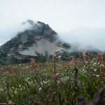
View from the big rock
After about 2 miles, the trail will split, with the left trail crossing a log bridge and the right trail going straight up the hill. A sign at this junction will tell you to go left to get to Twisp Pass, but will say that horses should go right to get to a better stock ford. I don’t blame them: the bridge was obviously put in place by the park service, but it can be scary for those who don’t like hights. The “bridge” is just a log with a flattened top; there are no railings or anything else to keep you from falling off. I enjoyed it, and so did several other members of my group, but others were just thankful they made it across 🙂 The trail from here goes straight, but a little to the right, up some large rocks. It may not be obvious, but once you get up the rocks, the trail will be easy to find again. A tenth of a mile later or so the trail for the stock will rejoin the hiker trail. At this junction, a sign will point (when you’re coming back down) that stock goes to the left, while hikers go to the right.

Wildflowers along the trail
From here, the trail really begins to ascend. However, take a second to go up to a viewing area on a large rock not very far beyond the bridge. These are the first of the views that you will see, and they are outstanding! You are on the edge of a valley that ends in a wall of (when we were there) snow-capped mountains. It’s lovely, and looks soooo much like the Cascade Range! Don’t use up all your memory on your camera card yet, though: there are actually better views to come!
Keep walking up the trail as it ascends higher and higher. Eventually, you will break out of the trees, and this is where the views get really nice. You are walking along a mountainside, with the valley next to you and snow-capped mountains all around. Gorgeous! There were also a few wildflowers out (although not as many as there had been a few weeks before), so that was an added bonus. I get the impression that when this place is in bloom, it’s not something to miss. The trail continues, reentering the trees, and playing peek-a-boo with the mountains. Within a mile of the pass, you will begin to see campsites where others have spent the night before hiking up to the pass or over into North Cascades.

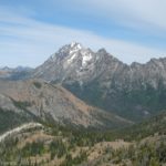
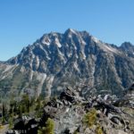
Stiletto Peak as seen from Twisp Pass
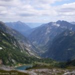
The last mile is probably the hardest, as the trail switchbacks its way fairly steeply up to the pass. Of course, by this time we were also all hungry and wanting lunch, so that could be part of why we found it difficult. However, you finally ascend the pass, come to a crossroads and—there’s no view. Unless you like to stare at evergreen trees. Because that’s all you can see from the crossroads. Going straight will take you into North Cascades National Park (which we all had to do just to say that we’d done it) and Dagger Lake, and the left trail will eventually take you to the Pacific Crest Trail. However, we opted to go right along a network of social trail. Eventually, we came to some rocks where we had a bit of a view, so we stopped and had lunch. Afterwards, we hiked slightly farther, and found an even better view. It seems that there are mountain peaks (some higher than others) in almost every direction, including some on either side of you. In the foreground is Dagger Lake, and beyond that is the beautiful North Cascades National Park, with truly Cascade-looking peaks. It was very nice, although it clouded over while we were there.

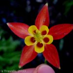
A Columbia Lily we found along the trail
Return by the way you came. One of the nice things about this area is that, excluding weekends, it isn’t overcrowded. We were there in the middle of the week, and when we left there were 4 vehicles in the parking area, and we saw no one until we were coming back. I love being out with just my own group, so that was great with me!
Round Trip Trail Length: 9 miles
Fees: $5 per day Northwest Forest Service Pass required; Interagency, Senior, Access, and Annual Passes can be hung in the windshield of your vehicle in place of the $5 fee.
Trail 
Road
Signs
Scenery
Would I go 100 miles out of my way for this?
Overall Rating:
This Week’s Featured Product!
The Cascade Mountains have a lot of great views, and this guide makes sure that you get to some of the best of them! Check it out on Amazon.