
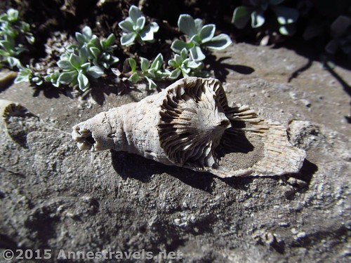
One of the fossils in Upper Darby Canyon
I was looking for hikes on the western side of the Tetons. That side is the non-tourist side; there aren’t many roads, let alone day hikeable trails, and there’s even less information on what’s out there. So my research wasn’t going so well until I stumbled on a map showing a trail up Darby Canyon. According to what I could find out, it was about 3 miles up to the Caves / Waterfall, then a couple more miles up to a saddle at the upper end of Darby Canyon, and no more than a couple miles beyond that to the Death Canyon Shelf and the Teton Crest Trail.
Quick Stats
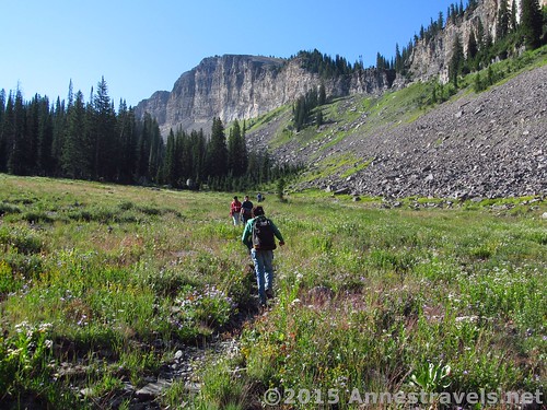
Hiking along the “trail” into Upper Darby Canyon
Well, the first part of that is true: It’s just over 3 miles to the Cave and Waterfall. But it’s a lot more than that – try 3 more miles – to the pass and even more – 3 miles at the very least – to the Teton Crest Trail. And that with a lot of very steep ups and downs, with no trail or only a vague trail.
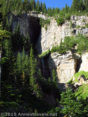
The cave and waterfall that separates Lower Darby Canyon from Upper Darby Canyon
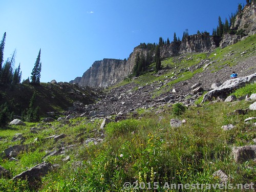
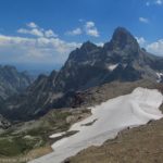
So suffice to say we didn’t make it to the Teton Crest Trail. But we did make it to the pass (12 miles RT) and a bit beyond to some good views (maybe 13 miles RT). Today, however, I’d like to focus on the middle part of Upper Darby Canyon, above the waterfalls and near the aptly named Fossil Mountain. Because what’s there to see is more than just canyon walls: there are myriads of fossils, mostly untouched, that seem to pop up at every turn in the boulder fields that grace the canyon bottom. There’s a trail almost all the way to the beginning of the fossils, so at least it’s about 8 miles more or less on a trail!
Examples of some of the fossils
The Darby Canyon Trail begins at the end of a dirt road, accessible even to passenger cars. The trail is first flat, obviously continuing on what was once the rest of the dirt road, enters the Jedidiah Smith Wilderness at mile 0.6, then begins switchbacking up what seems like the side of a sheer cliff. The geology in this section is interesting, reminding me of some parts of New England, with huge rocks and cliffs covered in moss. Not terribly long after this, the trail breaks out of the dense trees to switchback up the hillside.
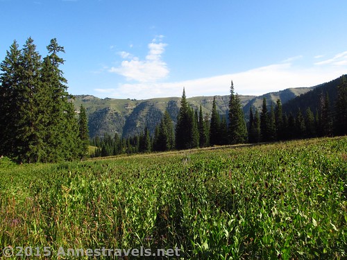
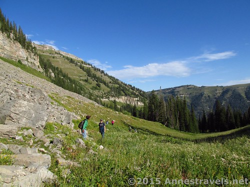
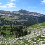
Meadows in Lower Darby Canyon
Keep going upward on the well-used trail until 3.1 miles from the trailhead near a large rock with a memorial to some cavers who never made it out of the cave. This part of the trail is fairly wide (by western Teton standards) because it’s a popular dayhike up to the waterfall, and climbers love to explore the cave above the waterfall. In the early morning, we had the entire trail to ourselves, but coming down it was almost a mad house…and most of the traffic was coming up!
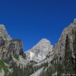
An early view of the cave across the canyon
At any rate, you’ll be able to see the falls and cave for quite a while before you get to the memorial. *Tip: if your destination is the saddle – not the fossils – I highly recommend turning left off trail maybe a quarter mile before the memorial and heading up through the dense meadows and a few stands of trees. Before long, you’ll be in easily traversed meadows and can simply walk upward to the saddle. I’ll talk more about that in next week’s post.
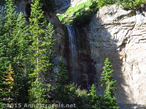
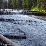
Darby Canyon Waterfall
At the memorial, turn right for 0.05 miles to an overlook of the falls and cave. It’s pretty impressive and well worth the side-jaunt. However, let’s just say that I was happy we weren’t trying to scramble up into the cave – it looked pretty treacherous to me!
One of the many social trails into Upper Darby Canyon
Return to the memorial and continue up the canyon. From here on out, the trails are social at best, so simply try to stick to the middle of the canyon on whatever trail seems the most traveled. We got on smaller, then regained the larger, trails several times along the way.
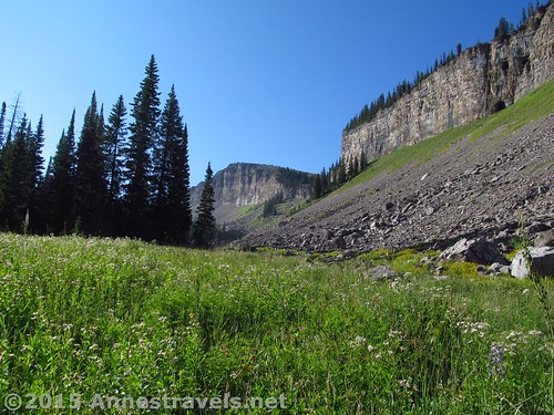
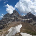
The views in this section are quite inspiring of the sheer canyon walls. Nothing earth shattering, but nice.
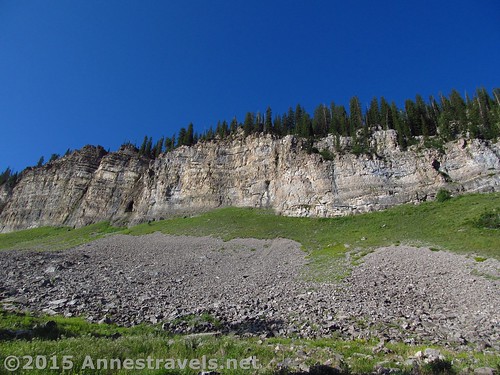
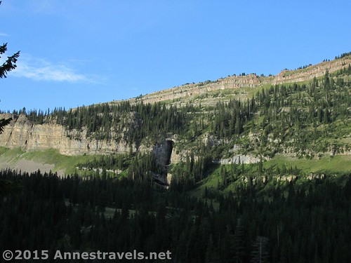
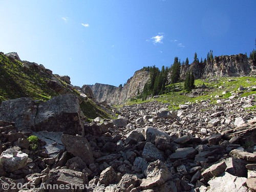
Cliffs above the lower reaches of Upper Darby Canyon
Eventually the trail will either peter out or suddenly go straight uphill, depending on exactly what trail you’re on. The trails here are sketchy; if you’re not good off trail, don’t keep going. If you’re ok with route finding and are used to not being rescued – you really are alone up here, and there’s no cell service – keep heading upwards. About a mile beyond the memorial, you’ll enter a boulder field with a large number of good-sized rocks (5 or 6 feet wide, or more). Start keeping your eyes out for fossils – they’re everywhere along in here!
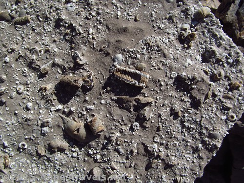
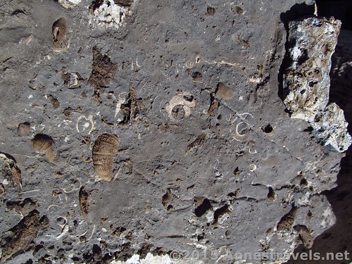
Sea life fossils
Most of the fossils seem to be sea life. There are a good number of shells, as well as what seem like sea worms, sea snails, and a lot of things I couldn’t identify. Still, it was all so cool. Most were 3D and entire rock surfaces were covered with fossils!
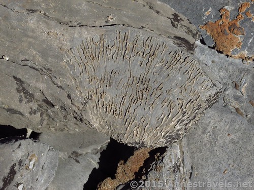
Sea worms?
From here, you can go back down or continue upward. The pass is nearly 2 miles away, or you can simply enjoy some more fossils and then go back down. It’s your choice…there’s no real trail, anyway!
Important! Do NOT remove any fossils from this area! It is a designated wilderness and therefore you may not remove any natural feature, even if there are plenty for others to enjoy!
Upward into Upper Darby Canyon
Round Trip Trail Length: Upwards of 8.1 miles
Lowest Elevation: 7,057 ft.
Highest Elevation: Upwards of 9,022 ft.
Net Elevation Gain: 1,965 ft. at the very least
Facilities: None – and it’s not necessarily easy to find a private bush, either!
Fees: None
Be Bear Aware – carry bear spray and know how to use it!
Looking back down from the middle reaches of Upper Darby Canyon
Trail 
Road
Signs
Scenery
Would I go 100 miles out of my way for this?
Overall Rating:
Key GPS Coordinates
Parking: 43.68639N / -110.96908W (43° 41′ 11.004″ / -110° 58′ 8.688″) (7,047 ft.)
Trail beginning: 43.68662N / -110.96880W (43° 41′ 11.8314″ / -110° 58′ 7.68″) (7,057 ft.) (ended 12.6)
Enter Jedidiah Smith Wilderness: 43.68467N / -110.95731W (43° 41′ 4.8114″ / -110° 57′ 26.316″) (7,141 ft.) (0.6)
Cave / waterfall view: 43.66692N / -110.95502W (43° 40′ 0.9114″ / -110° 57′ 18.072″) (8,433 ft.) (3.1)
Cave trail junction: 43.66655N / -110.95465W (43° 39′ 59.58″ / -110° 57′ 16.74″) (8,456 ft.) (3.2)
Beginning of fossils: 43.65742N / -110.94730W (43° 39′ 26.712″ / -110° 56′ 50.2794″) (9,022 ft.) (4.1)
(Optional) Regain trail up to Pass: 43.65236N / -110.93098W (43° 39′ 8.496″ / -110° 55′ 51.528″) (9,816 ft.) (5.7)
(Optional) Pass: 43.65145N / -110.92734W (43° 39′ 5.2194″ / -110° 55′ 38.424″) (9,945 ft.) (5.9)
The gpx file for my hike up Darby Canyon can be downloaded – please note that this and the GPS Coordinates are for reference only and should not be used as a sole resource when hiking this trail.
Download GPX File size: 306.2 KB Downloaded 137 times
(Note: I do my best to ensure that all downloads, the webpage, etc. are virus-free and accurate; however, I cannot be held responsible for any damage that might result, including but not limited to loss of data, damages to hardware, harm to users, from use of files, information, etc. from this website. Thanks!)
Up over the scree in Upper Darby Canyon
Getting to Darby Canyon
If coming from the South (or from Jackson Hole): From the town (ok, hamlet) of Victor, ID, continue north on ID-33W for 5.3 miles. Turn right onto W 3000 S (if you get to the Spud Drive In Theatre, you’ve gone too far) and drive 3.2 miles; then turn right on S Stateline Road (yes, you’re reentering Wyoming) for 0.1 miles. The main road will take a sharp turn to the left; stay to the main road to continue on Darby Canyon Road for 4.2 miles to the large – if rambling – parking area. The roads are in good condition are should be doable by passenger cars, even though most of the vehicles I saw were pickups and jeeps.
If coming from the North: From Driggs, ID, drive south on ID-33E exactly 3 miles. Pass the Spud Drive In Theatre, then turn left on W 3000 S. Follow the directions above to the parking area. Note: A car GPS is quite helpful in getting to this place – just put in the coordinates and let Garmin do the rest!
Zoom map out to browse nearby hikes & places of interest
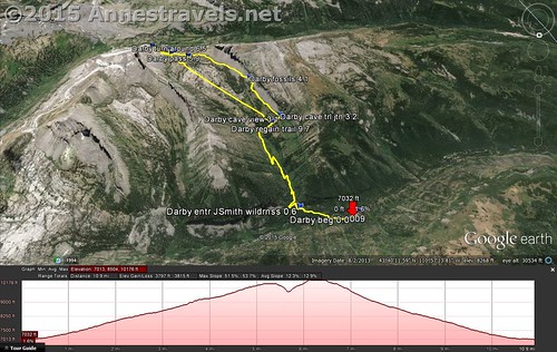
Visual map of the trail from Lower Darby Canyon up through Upper Darby Canyon to a Pass, then along the side of Fossil Mountain to views to the Teton Crest Trail. The trail to the fossils is on the right.
This Week’s Featured Product!
Love the geology of the Tetons? You’re in luck! This book describes the geological formation of Yellowstone and the Tetons, factually, yet understandably, with lively accounts from locals, part rangers, and tourist.
Pingback: Blog Sneak Peak: The Wyoming You Never Knew
Pingback: The Pass & Views above Upper Darby Canyon - Anne's Travels
Pingback: The Top 15 Pages on Anne's Travels in 2016 - Anne's Travels
Pingback: 12 Best Day Hikes in Grand Teton National Park - Anne's Travels