
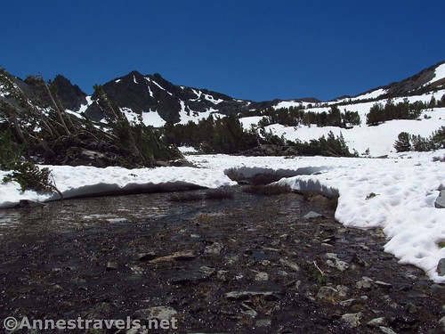
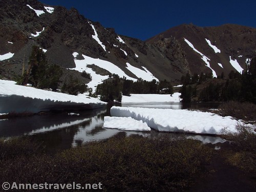
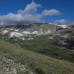
The stream frees itself from the snow just below K19 Viewpoint
The Virginia Lakes! They are beautiful, especially early in the season when they are surrounded by snow. But at any time of the summer or fall they are a destination well worth visiting – near enough to Yosemite National Park to be included on an itinerary to the park, but far enough away to not be overrun with tourists. In fact, get past the parking lot, and you’ll likely only see wilderness hikers or people fishing.
Quick Stats for the Virginia Lakes Trail

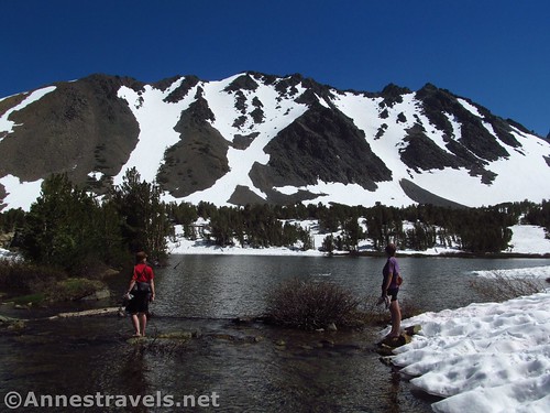
Cooney Lake is very popular with anglers
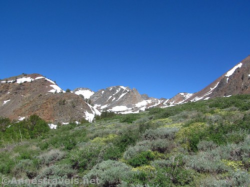
As I went when the trail was still so snowcovered it was hard to even find the trail at higher elevations, I didn’t see too many of either hikers or people with fishing poles. But the snow added a charm I can only express as jaw-dropping. Really, this is a great early summer hike (if you can deal with a bit of snow), even if I only made it up to K19, a pile of rocks in the cirque below Burro Pass.
Snowy conditions near K19
To give you an idea of when I hiked the trail, the Tioga Road had opened the day before. It was late June, but after 200% snowpack the winter before, the Sierras were very much still under snowpack.
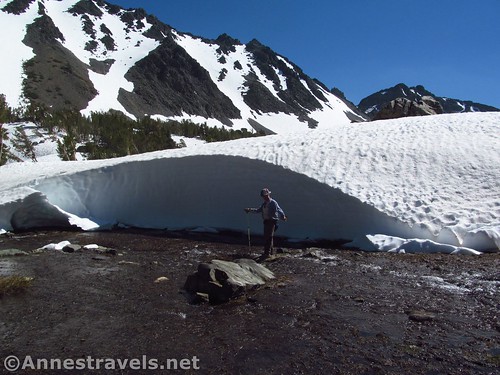
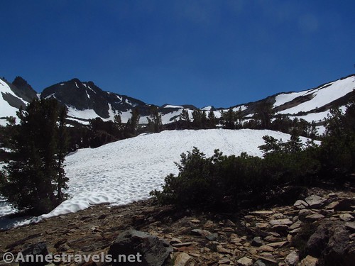
Snowbank near the Frog Lakes. If he was actually standing next to the snowbank, it would be at least twice as tall as his 6′ frame.
The parking area was just nice – not particularly snowy, though the mountains across the lake had enough snow on them still. I didn’t blame all the people out on the lakeshore in their lawn chairs enjoying the view.
Views from the parking area
Several trails – most of them unmarked – leave from the parking area. I took the one that headed uphill near the signboards behind the primitive restroom. Pretty quickly this joins the main trail (you might even miss that you’ve joined anything but another social trail). At 0.25 miles, veer left as the trail joins a much larger trail; this goes over to a campground or the road (not quite sure which; I didn’t bother hiking it to find out). A tenth of a mile later, enter the Hoover Wilderness, and a tenth of a mile after that, arrive at the base of Blue Lake.
The earliest part of the trail gives a taste of what’s to come
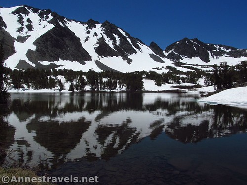
This is where the views begin, and what views! The snow and cliffs around the lake gave way to its sparkling waters, with just enough foliage for a really stunning setting. And the reflections were awesome!
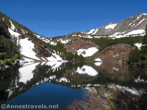
Reflections on Blue Lake
The trail skirts the north side of the lake, emerging from the trees to rise along the scree hillside. This was where we met our first snowfield. Thankfully, plenty of people had gone ahead of us, and their footprints led us upward for a bit. We finally reintersected the trail about the time it entered the forest high above Blue Lake’s western shore. If we had turned left here (back down the trail) it would have taken us to a very nice view over Blue Lake. But we didn’t find that until the way back.
Views down on Blue Lake
So we continued upward through the trees and open areas, finding more and more snow the more elevation we gained – about 300ft. in about a mile, rising through the forest past (in season) plenty of small streams and little waterfalls.

The old mining cabin
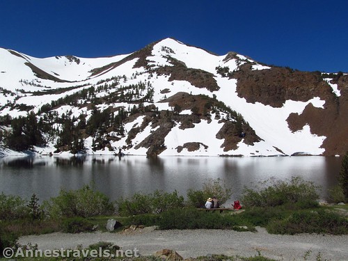
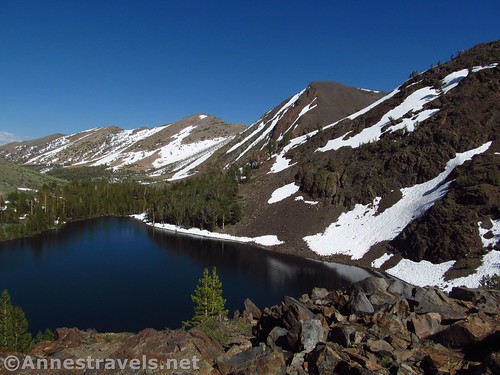
At 0.6 miles from the trailhead (or about 0.2 miles beyond the end of Blue Lake), the trail passes an old mining cabin. It’s still in fairly good shape, and has plenty of rusty stuff inside just to prove that it’s a real abandoned cabin. Keep going upward through the forest (snow or no snow) to the final push up to Cooney Lake (a favorite with anglers, I hear) at mile 1.3. This is another lovely lake, with cliffs, pines, scree, views toward the distant passes and peaks, and (in season) a snowy disposition. At the far end of the lake, some icebergs clung to the bounders; later in the day, one had broken off and was floating in the lake.
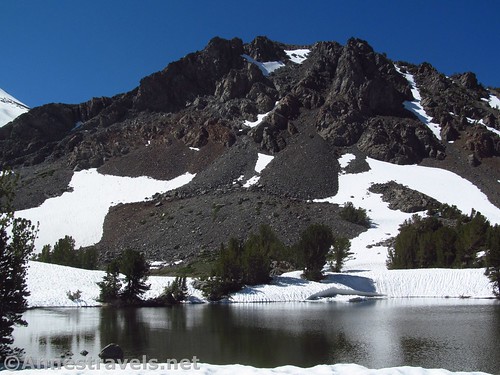
Cooney Lake
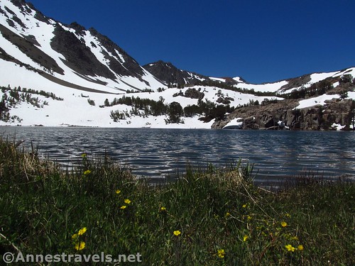
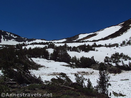
After skirting the north side of Cooney Lake, the trail climbs fairly quickly to the Frog Lakes a half mile later. This was where we hit real snow; the trail simply wasn’t anymore. Thankfully, my trusty GPS showed the trail, so I kept half an eye on that and half and eye on my footing to stay generally on the trail.
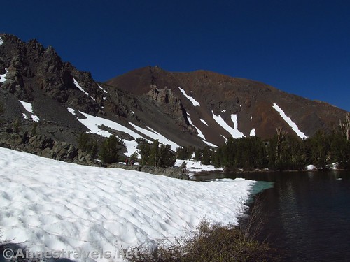
The middle of the Frog Lakes (and its icebergs)
We crossed the outlet between two of the Frog Lakes; I guess the trail actually crosses at the foot of the first lake and then skirts the southern shore before (like us) crossing the outlet / inlet on the north side of the uppermost of the Frog Lakes. This was a bit of an exciting crossing; several of us decided the simplest method was just to take off our socks and shoes and wade across (it’s only calf deep, shallower closer to the uppermost Frog Lake). I figured my hiking boots could handle it, and rocked-hopped across. Later in the season, this would be a simple rock-hop crossing.
Fording the outlet between two of the Frog Lakes
The trail keeps climbing after the Frog Lakes up above another lake via a quite steep trail to 11,120ft. Burro Pass (local name) at mile 2.8 (if you listen to Yosemite National Park: A Complete Hikers’ Guide by Jeffery Schaffer; I beg to differ that it’s closer to 3.5 miles from the parking area to the pass). But the snow was taking its toll on my group. I went scouting above the uppermost of the Frog Lakes, skirted a nasty dip in the snow where it had sunk over a currently invisible stream, crossed the stream where it showed itself through the snow, and climbed a pile of rocks in the middle of the cirque below Burro Pass at mile 2.5.
Burro Pass is that dip in the middle of the ridgeline
It was a beautiful place, surrounded by snow and stands of broken pines, evidence of the harsh winter and a few avalanches. High above the cliffs soared, still snow speckled, grey and red. Below was not only the valley we were ascending, but also the blue waters of the uppermost of the Frog Lakes. Totally spectacular!
My group arrived, and promptly christened the rock pile K19. Why? I have no idea!
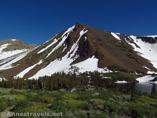
Burro Pass and the cirque below it from K19
We sat around enjoying the view for a bit, discussing the advisability of climbing up to Burro Pass in the current conditions. We finally decided that between the time of day (we hadn’t exactly gotten an early start), the snow, steepness, and current energy levels, we’d just have to leave that for another day.
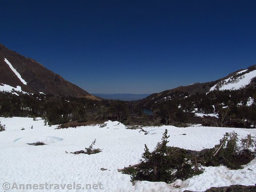
Down the valley from K19 is the Frog Lakes
So we ate a snack and headed back down. The one mistake we made coming down was to try and follow the trail at the western end of Blue Lake. While the views were great, the snow was not, and let’s just say I ended up catching not only a hiker or two, but also several water bottles as we tried to slide down a crazy snow slope. Nope, I’d take the snowy non-trail any day!
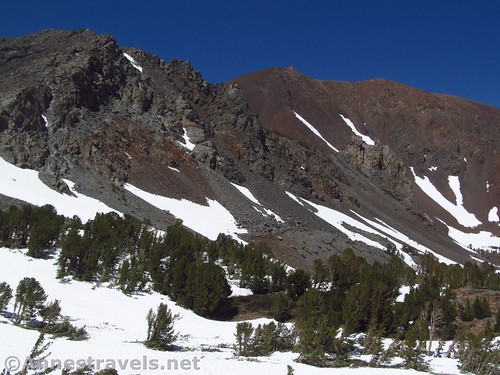
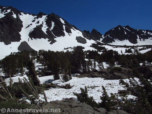
Some of the peaks near K19. I think Moat Lake is up there somewhere…
Back at the parking area, I ended up on a social trail that took me down at the road end of the parking area. But hey, it got me there!
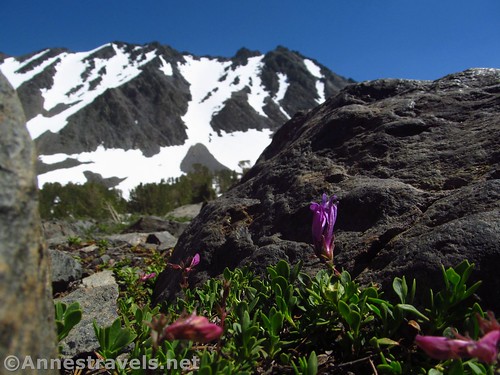
Wildflowers in the rocks of K19
Round Trip Trail Length: Up to K19 and back, my GPS was reading 5.4 miles, but it’s probably closer to 5.0 miles
Net Elevation Change: 646ft. (9,815ft. at the parking area to 10,461ft. at K19)
Facilities: Primitive restrooms and a couple picnic tables at the parking area. Despite reports on the internet that you can sleep overnight in the parking area, there are signs stating otherwise.
Fees: None
Trail Notes: If you do this early in the season, be prepared for winter travel. I would suspect the cirque around K19 is an avalanche chute. Later in the season, I hear it’s nearly as spectacular, minus the snow.
Across the uppermost Frog Lake
Trail 
Road
Signs
Scenery
Would I go 100 miles out of my way for this?
Overall Rating:
Mountains between the Virginia Lakes and Blue Lake
Key GPS Coordinates for the Virginia Lakes Trail to K19
Note: Because of the snow, I didn’t always stick to the trail. Take trail mileages with a grain of salt.
Trailhead: 38.0480583°N, -119.2632250°W (38°02.88350’N, -119°15.79350’W / 38° 2’53.01″N, -119°15’47.61″W) (9,815ft.) (0.0; ended 5.46)
Trail Junction: 38.0497222°N, -119.2646694°W (38°02.98333’N, -119°15.88017’W / 38° 2’59.00″N, -119°15’52.81″W) (9,861ft.) (0.25)
Enter Hoover Wilderness: 38.0506750°N, -119.2673472°W (38°03.04050’N, -119°16.04083’W / 38° 3’2.43″N, -119°16’2.45″W) (9,858ft.) (0.3)
Blue Lake: 38.0510722°N, -119.2684528°W (38°03.06433’N, -119°16.10717’W / 38° 3’3.86″N, -119°16’6.43″W) (9,856ft.) (0.44; end of lake 0.61)
Mining Cabin: 38.0503639°N, -119.2748194°W (38°03.02183’N, -119°16.48917’W / 38° 3’1.31″N, -119°16’29.35″W) (10,138ft.) (1.1)
Cooney Lake: 38.0488583°N, -119.2759500°W (38°02.93150’N, -119°16.55700’W / 38° 2’55.89″N, -119°16’33.42″W) (10,190ft.) (1.3)
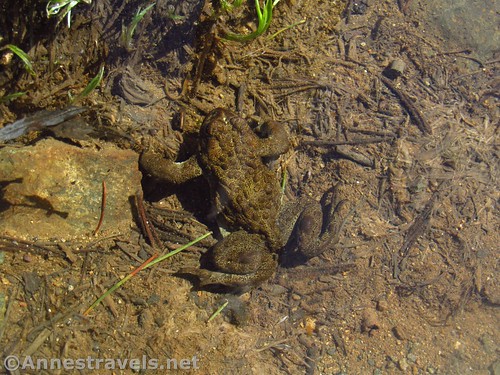
A frog at the Frog Lakes
Frog Lakes: 38.0485944°N, -119.2802639°W (38°02.91567’N, -119°16.81583’W / 38° 2’54.94″N, -119°16’48.95″W) (10,332ft.) (1.8)
View over Upper Frog Lake: 38.0486278°N, -119.2820778°W (38°02.91767’N, -119°16.92467’W / 38° 2’55.06″N, -119°16’55.48″W) (10,370ft.) (2.1)
K19 Viewpoint: 38.0471444°N, -119.2849861°W (38°02.82867’N, -119°17.09917’W / 38° 2’49.72″N, -119°17’5.95″W) (10,461ft.) (Arrived 2.5, left 2.9)
Blue Lake Overlook: 38.0517167°N, -119.2723000°W (38°03.10300’N, -119°16.33800’W / 38° 3’6.18″N, -119°16’20.28″W) (10,038ft.) (4.5)
End (different than beginning): 38.0482306°N, -119.2625000°W (38°02.89383’N, -119°15.75000’W / 38° 2’53.63″N, -119°15’45.00″W) (9,814ft.) (5.46)
Hiking along the uppermost Frog Lake
The gpx file for the Virginia Lakes Trail to K19 can be downloaded – please note that this and the GPS Coordinates are for reference only and should not be used as a sole resource when hiking this trail. Also note that because of the snow, I did not follow the trail exactly.
Download GPX File size: 154.8 KB Downloaded 76 times
(Note: I do my best to ensure that all downloads, the webpage, etc. are virus-free and accurate; however, I cannot be held responsible for any damage that might result, including but not limited to loss of data, damages to hardware, harm to users, from use of files, information, etc. from this website. Thanks!)
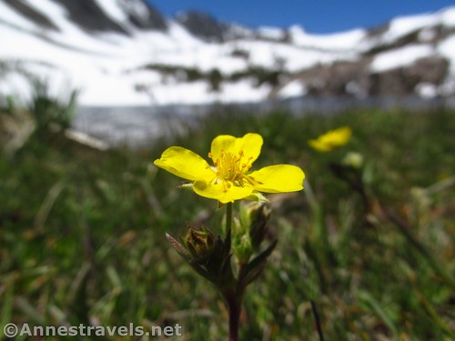
Buttercup at Cooney Lake
Getting to the Virginia Lakes Trailhead
From Lee Vining (just north of the east end of the Tioga Road), take the main highway (US-395N) 12 miles. Turn left onto the Virginia Lakes Road at the top of the pass; drive 6 miles to the gravel parking area at the end of the road. (Note: part of the road is unpaved, but should be passable to low clearance vehicles without issue, at least once it’s snow-free and graded.)
The uppermost Frog Lake
Or from Bridgeport, CA, drive south on US-395S (the main highway) 13 miles. At the top of the pass, turn right onto the Virginia Lakes Road at the top of the pass; drive 6 miles to the gravel parking area at the end of the road. (Note: part of the road is unpaved, but should be passable to low clearance vehicles without issue, at least once it’s snow-free and graded.)
Zoom map out to browse nearby hikes & places of interest
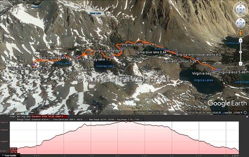
A visual trail map and elevation profile for the Virginia Lakes Trail from the trailhead to K19 Viewpoint above the Frog Lakes
This Week’s Featured Product!
I used this book extensively to plan my recent trip to Yosemite. It’s great, with detailed trail descriptions, options, and easy-to-follow trail mileages.


We were just there on Saturday, July 29. Still a lot of snow, but not as much as in your pics. Such a lovely place, I’d like to go back in fall when all those aspens turn color.
Kelly – Amazing that we were in the same place, only a month apart! I was surprised what even a week did to the snow above Mammoth Lakes. Maybe by the time the aspens are out most of the snow will be gone…
Pingback: Sneak Peak: A California Trip through Desert and Snow - Anne's Travels
Pingback: When You Pass through the Waters - Anne's Travels