
Zone 9
Appalachians (Pennsylvania, Maryland, West Virginia, Virginia, North Carolina, South Carolina, Georgia)
Pennsylvania
Dismal Run Trail
3.6 mile double loop; 300ft. elevation gain; Moderate
Forest, stream, historical interest; Media
Dismal Run Trail; access via the Scenic Loop Trail
Maryland

Parkers Creek Loop
3.7 miles loop; 323ft. elevation gain; Moderately Strenuous
Forest, views; Prince Frederick
Parkers Creek Loop Trail Guide
West Virginia

Seneca State Forest Trail
4.2 mile lollipop loop; 750ft. elevation gain; Easy to Moderate
Forest, views, fire tower; Seneca State Forest
Seneca State Forest Trail Guide
Virginia
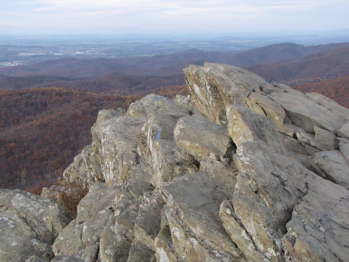
Humpback Rocks
4.0 miles out & back; 1,240ft. elevation gain; Strenuous
Forest, views, rocks; Waynesboro
North Carolina

Little Long Mountain
12.6 miles out & back; 1,883ft. elevation gain; Moderate
Forest, views, backpacking; Uwharrie National Forest
Little Long Mountain Trail Guide
South Carolina

Rocky Creek Trail
3.4 mile out & back; 46ft. elevation gain; Easy to Moderate
Waterfall, creek, forest; Great Falls
Georgia

East Palisades Route
4.2 mile loop; 472ft. elevation gain; Easy to Moderate
Views, creek, forest, historical interest, botanical interest; Chattahoochee River National Recreation Area
Zone 10
New England & Atlantic Coast (Maine, New Hampshire, Vermont, Massachusetts, Rhode Island, Connecticut, New Jersey, Delaware)
Maine

Good Will-Hinckley Trails
2.8 mile loop; 144ft. elevation gain; Easy to Moderate
Good Will-Hinckley Trail System Guide
New Hampshire

West and East Rattlesnake Mountain via the Old Bridal Path
3.1 miles out & back; 853ft. elevation gain; Moderate
Views, forest, mountains; West Rattlesnake Natural Area
Rattlesnake Mountain Trail Guide
Vermont

Haystack Mountain
4.0 miles out & back; 1,026ft. elevation gain; Moderate
Forest, views, mountains; Green Mountain National Forest
Massachusetts
Flag Rock
3.9 miles out & back; 796ft. elevation gain; Moderate
Views, forest; Monument Mountain Reservation
Connecticut

Vista and Devils Oven
2.2 mile loop; 462ft. elevation gain; Moderate
Waterfall, forest, rocks, cave, view, covered bridge; Devils Hopyard State Park
Vista and Devils Oven Trail Guide
New Jersey

Atsion to Quaker Bridge Loop
5.5-9.6 miles out & back or lollipop loop; 92ft. elevation gain; Moderate
Forest, ponds, historical interest; Wharton State Forest
Atsion to Quaker Bridge Loop Trail Guide
Delaware
Bob Loop Trail
5.0 miles out & back; 35ft. elevation gain; Easy
Forest, lake; Laurel
The gravel “Bob Loop” trail around Trap Pond isn’t difficult, but it’s a great little hike with some interesting flora and fauna along the way.