
Zone 1
Pacific Northwest (Oregon, Washington)
Washington

Boulder River Trail
8.3 miles out & back; 773ft. elevation gain; Moderate
Forest; creek; waterfalls; Mount Baker National Forest

Rosario to the Points and Back
4.1 miles multi spur; 534ft. elevation gain; Moderate
Views; ocean; Deception Pass State Park
Rosario to the Points and Back Trail Guide
Oregon

Diamond Creek Falls
3.7 mile lollipop loop; 450ft. elevation gain; Easy
Waterfalls, Lake, Canyon, Forest
Diamond Creek Falls Trail Guide

Cathedral Trees Loop
3.3 mile loop; 205ft. elevation gain; Easy
Forest; redwood trees; Prairie Creek Redwoods State Park
Cathedral Trees Loop Trail Guide
Zone 2
Northern Southwest (Utah, Nevada, California)
California

Palomarin to Alamere Falls
8.3 miles out & back; 991ft. elevation gain; Moderate
Forest; beach; waterfall; Point Reyes National Seashore
Palomarin to Alamere Falls Trail Guide
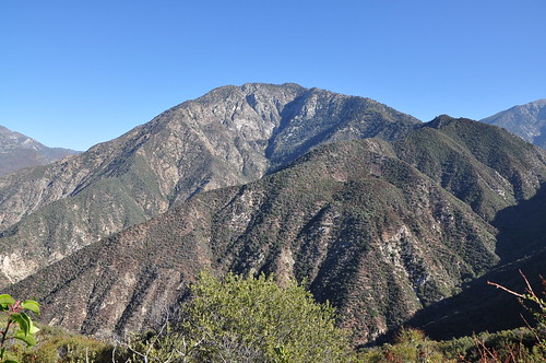
Iron Mountain Peak Trail #10
5.8 miles out & back; 1,067ft. elevation gain; Moderately Strenuous
Views; Poway
Iron Mountain Peak Trail #10 Guide
Nevada
Mud Wash Dunes and Lollipop Panel
1.25 miles out & back; 43ft. elevation change; Easy
Rock art; sand dunes; views; Gold Butte National Monument
Mud Wash Dunes and Lollipop Panel Route Guide
Utah

Sunrise & Sunset Arches
2.5 miles out & back; 277ft. elevation change; Easy
Arches, views; Grand Staircase-Escalante National Monument
Sunrise & Sunset Arches Trail Guide

The Windows & Double Arch
1.3+0.5 mile loop + out & back; 205ft. + 197ft.; Easy
Arches; views; Arches National Park