The trail to Silver Lake is quite a bit more than meets the eye. It’s only a little over 6 miles RT, but the elevation gain means the trail is much steeper than you might think. It was harder than I expected, and I was closing in on 150 miles in the past three weeks. But the views are spectacular. So if you don’t mind a bit of puffing and panting – and a high-clearance-required road to get to the trailhead – it’s a great option if you’re near Ketchum.
Quick Stats

Silver Lake isn’t exactly in the Sawtooth Mountains. It’s just outside of the Hemingway-Boulders Wilderness in the Boulder Mountains north of Ketchum. I decided that it was too far to drive to the traditional area of the Sawtooths National Recreation Area, so we’d do this for a day before heading north.

I also decided that we should eat lunch before we headed out (a very good idea, even if it was only 11:30am by my watch, which was still on EDT). As we shifted snacks and chewed our pulled-pork-from-a-packet sandwiches, a national forest jeep hurtled up the dirt road, intent on… well, it quickly became obvious that he was intent on us. We knew we weren’t doing anything wrong, so we kept eating and packing daypacks, even when his eyes gleamed as he saw our New York license plate. I made sure I was in front of the van when the ranger – who was actually from the Fish and Wildlife Service – hopped out of the jeep.
We chatted for a few minutes. It turned out that he thought we were poachers. (I kid you not.) But I guess we didn’t look like poachers, and even if he’d searched the van, he wouldn’t have found any firearms that would have been used by a poacher. We wished him a good day, and he dashed off to stay on the lookout for more likely law-breakers. To be honest, I felt sorry for him – he and his crew were trying to perform the not-quite-impossible task of retaining law and order with hunters, and we were bystanders in a much bigger problem.
As it turned out, he wasn’t the only person who dashed around on that dirt road. Someone else flew up on their side-by-side as we ate dinner that night. He was in a dreadful hurry; leaping out of the go-cart and hastily dialing a number on his cell phone. He talked for several minutes – I’m not sure about what, but it didn’t seem urgent – and then he headed back down the mountain. Apparently cell service is better up at the trailhead than at the campground at the base of the road!
There are two ways to begin the hike to Silver Lake. One is to continue up the road (which is closed at this point) – this is the way I came down. The other is to take the obvious trail straight up the hillside (about 0.2 miles shorter than the road). We chose to take the trail route up. It cuts off a few switchbacks and offers great views (as does the road) back down into the valley and over into the Smokey Mountains.

After 0.3 miles, the path more or less ends at an old dirt road. You have two choices here: Turn right (not logical, I know, but it happens to be correct) to follow the road and then turn left when you reach the “main” road, or else cross-country straight to intersect the “main” road further up. We continued straight and met the main road about a tenth of a mile later.

Turn left and continue to follow the old, disused road another 0.3 miles up to what is obviously the old parking lot – Google Maps still shows the road as open, so I’m going to guess that the road hasn’t been closed for more than 2-3 years. Turn left-ish here to follow what’s either a well-defined trail or a continuation of the road up into the trees.
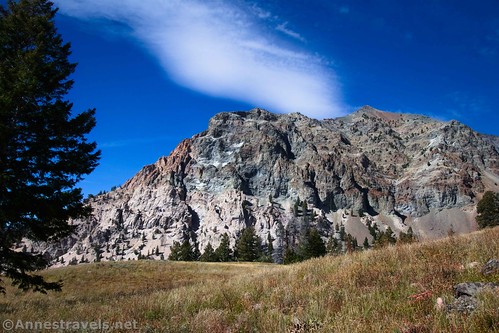
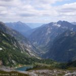
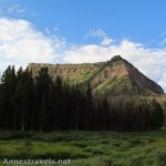
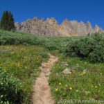
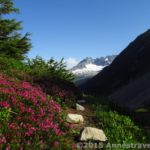
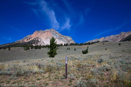
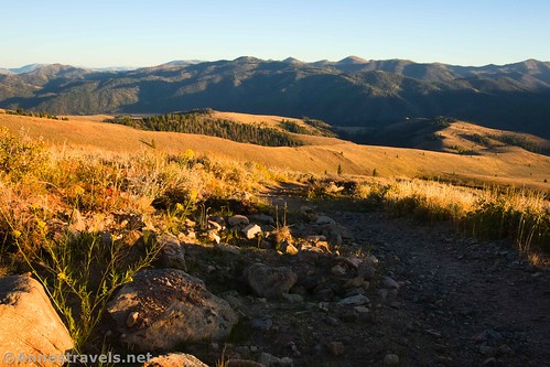
The trees don’t last very long, and you’re fairly quickly out in open meadows again. At this point, you’re beginning to hike up the valley in which Silver Lake is nestled – even if you’re nowhere close to it yet. Enjoy views to the left of UN10570 and to the right (at the right of the head of the valley) of Silver Peak.

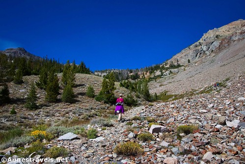
As the path continues upward, it becomes rockier and rougher, eventually working its way along the steep hillside. Meadows and rock areas continue through most of the rest of the hike. Few people talk about this section because, while it’s beautiful, it’s mostly just a long, steep hike upward.
The one really fun thing is meeting up with the outlet of Silver Lake and a few other small lakes and springs. It’s lovely as it jumps down its classic alpine-creek course.

There were also still wildflowers in this area, even though it was mid-September. Gorgeous!

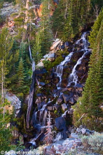
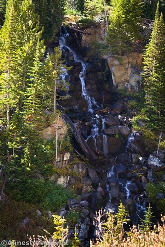
The trail also led us by views of a very nice waterfall.
We continued to follow the trail upward (it’s still steep!) until it crossed the creek about mile 2.4. At this point, we basically lost the trail. But what a lovely setting to lose something as important as the trail! The little creek babbled through lovely meadows below towering cliffs.

To get to Silver Lake, we should have headed west here (turned left if looking upstream). But we didn’t know that, and my ten-year-old GPS was having trouble accepting the fact that it could, indeed, show GPS tracks that I loaded just for this purpose, let alone maps. So we continued to follow the stream uphill.
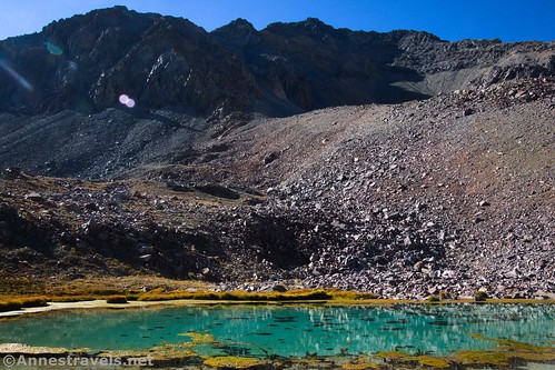
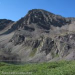
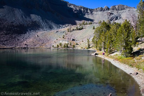
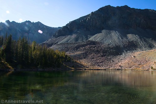
This took us much further up the valley to a gem of a lake, cupped just below the headwall and UN10726. It was deep blue, and it was so worth seeing!

Some of my group scouted around and managed to figure out the general location of the much larger Silver Lake. So after eating a snack, we trotted off through the forests and rock slides to descend (south, mostly, and a little west) to the shores of Silver Lake.

After the lovely gem higher in the valley, Silver Lake was a bit of a disappointment. It’s bigger, and I’d imagine in the morning it could be quite lovely. But as it was, the sun was at the wrong angle for enjoying it or taking pictures. Beyond that, we were all pretty tired (most of the group had flown in the night before at 2am home time), and the sun was moving far too quickly toward the horizon.
We never did locate the trail to Silver Lake and instead just went overland back to the stream crossing (east and a little north). Note that the stream crossing is just above where the stream drops into a small canyon, so you’ll need to stay far enough north to avoid the steep walls of the gorge.

Going down was easier, though I wished I’d thought to bring my hiking poles. The sun slowly sank, we picked our way down the very steep trail, and the golden hour light made some of the views even better!

At last, 6.4 miles later, we returned to our van in the parking area before the sun ducked behind the mountains. Yay! Mission accomplished… though I’d like to be in better mountaineering shape before trying Silver Lake again!
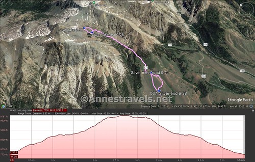
Round Trip Trail Length: Around 6.4 miles, depending on your route
Elevation Gain: I went 2,460ft. (7,730ft. to 9,787ft.)
Facilities: None, although there is a small (free, I believe) camping area with pit toilets at the bottom of the road.
Fees: None

Trail Notes: Given the grade of this hike, you’ll probably want to bring along your hiking poles and some good lungs (just kidding, but you get the idea). We did meet a couple of young guys obviously out looking for good places to hunt. (They weren’t thrilled to see us, and they didn’t bring anything back… I’m guessing they were just scouting, though they had enough gear with them.) There are very few “private bushes” on this hike (or near the parking area), so you might want to take advantage of the trees near the old parking area. I’d imagine the entire hike would be a profusion of wildflowers in the early summer.

Trail 
![]()
![]()
![]()
Road ![]()
![]()
Signs ![]()
![]()
![]()
![]()
Scenery ![]()
Would I go 100 miles out of my way for this? ![]()
Overall Rating: ![]()
![]()

GPS Coordinates for Silver Lake
TH: 43.8126420°, -114.5485810° (43°48.75852′, -114°32.91486′ / 43°48’45.5112″, -114°32’54.8916″) (7,734ft.) (0.0)
Meet road: 43.8174530°, -114.5449180° (43°49.04718′, -114°32.69508′ / 43°49’02.8308″, -114°32’41.7048″) (8,178ft.) (0.44)
Unnamed Lake: 43.8410770°, -114.5485890° (43°50.46462′, -114°32.91534′ / 43°50’27.8772″, -114°32’54.9204″) (9,787ft.) (2.90)
Silver Lake Outlet: 43.8382050°, -114.5480140° (43°50.29230′, -114°32.88084′ / 43°50’17.5380″, -114°32’52.8504″) (9,670ft.) (3.28)
End at TH (via road): 43.8126130°, -114.5484980° (43°48.75678′, -114°32.90988′ / 43°48’45.4068″, -114°32’54.5928″) (7,734ft.) (6.38)
The gpx file for Silver Lake can be downloaded – please note that this and the GPS Coordinates are for reference only and should not be used as a sole resource when hiking this trail.
Download GPX File size: 148.9 KB Downloaded 385 times
(Note: I do my best to ensure that all downloads, the webpage, etc. are virus-free and accurate; however, I cannot be held responsible for any damage that might result, including but not limited to loss of data, damages to hardware, harm to users, from use of files, information, etc. from this website. Thanks!)

Getting to the Silver Lake Trailhead
From Ketchum, ID, drive north on ID-75 (toward Stanley, not toward Sun Valley). After about 15.7 miles, turn right onto Silver Creek Road (a small sign should say Silver Creek). (This turn is 45.2 miles south of Stanley, ID.) Continue straight to cross the bridge – do not turn right or left into the camping areas. After crossing the Big Wood River, the road begins twisting up into the mountains. The road is amazingly steep and dirt/gravel – don’t try this in wet or snowy weather. After 2.4 miles, the road ends in a small parking area. Per aerial imagery on Google Maps, the road continues, and no parking area exists here, so I’m thinking that the road has been fairly recently closed at this point. Park here.
Today’s Featured Product!
A total of 63 trails are discussed in this guide to the area near the Sawtooth Mountains. Mountaintop experiences and alpine lakes combine with mountain biking and hiking trails that are sure to give you great adventures. Buy your copy here!