

Surrounded by Cascade Peaks…overlooks of Middle Earth-like lakes…waterfalls…glaciers…views that take your breath away…yup, that’s Cascade Pass and Sahale Arm in North Cascades National Park. I don’t recall ever seeing a view like this, not because the views are so spectacular (although they are), but because rarely have I been in a place where the peaks tower so closely around you and yet add to, instead of obstruct, the view. The view of Doubtful Lake is also dizzying beautiful and reminds me of my mental image of Middle Earth. The 11.8-mile (18.9 km) RT hike is also flexible enough to be a day hike or an overnight trek. You might even get a glimpse of wildlife such as marmots or mountain goats. What could be better?
(Affiliate links are present on this page.)
Key GPS Coordinates for Cascade Pass and Sahale Arm:
Where Cascade River Road leaves Route 20: 48.526720N / -121.430801W (48N 31’ 36.1914” / -121 25’ 50.8836”)
Cascade Pass/Sahale Arm Parking Area: 48.475244N / -121.075387W (48N 28’ 30.8784” / -121 4’ 31.3932”)
Cascade Pass: 48.467604N / -121.059052W (48N 28’ 3.3744” / -121 3’ 32.5866”)
Sahale Arm/Doubtful Lake Intersection (Approxomite): 48.470602N / -121.051800W (48N 28’ 14.1666” / -121 3’ 6.48”)
End of the Sahale Arm Trail (Approxomite): 48.482555N / -121.050560W (48N 28’ 57.1974” / -121 3’ 2.016”)
Getting to Cascade Pass and Sahale Arm:
From Marblemount on Route 20, take Cascade River Road 23.1 miles (37.1 km) until it ends in the Cascade Pass parking area. (In other words, after you cross the river just to the east of Marblemount, keep going straight when Route 20 takes a hard turn to the left; drive to the end of this road.) The road is paved for the first 8-10 miles (12-16 km), then becomes gravel (a low-clearance vehicle could have easily driven it when we visited in mid-August; I saw several at the trailhead). The road usually opens in June or July (depending on snow cover) and closes in the early fall due to snow. However, you could snowshoe it or even cross-country ski it while it’s under snow. Park in the parking area, and then head up to the right end. This is where the trail begins.
The trail is well-defined, and immediately begins to climb uphill through the forest. Along the way you’ll get peak-a-boo views of the canyon you just drove up. The best of these views is at the end of a switchback near a large rock; a small social trail will take you to the view and a small waterfall. The trail in this section is very steep, so keep this in mind.
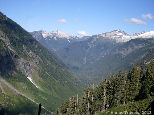
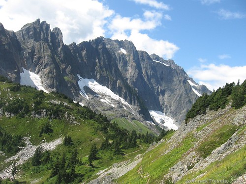
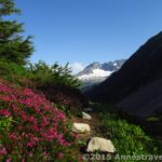
Then, suddenly, you break out of the trees and you can see some of the views at last. Wow! The canyon twists away behind you, with numerous cascades (we saw up to 14 in a dry summer) tumbling down its walls. All around you the peaks rise high and majestic; there was even snow on them after a very warm, dry summer. Amazing!
The trail is less steep from here to Cascade Pass, 3.7 miles (5.9 km) from the trailhead. My opinion of Cascade Pass was, “Soooooo?????”. There’s nothing there except a few trees and some places to camp. So, if you in this for the views and don’t want to go any further, I’d recommend stopping along the last not-so-steep section of trail where there actually are views to be seen. The day we hiked the trail, a local newspaper had featured an article about the pass, so it was quite overrun (it was also a Saturday). We decided that going further couldn’t be much worse, so we continued along the Sahale Arm Trail for another hundred feet or so to some boulders where we could eat lunch.
The day wasn’t half through yet, and we could see the trail twisting upward above us. It looked like there would be some great views up there…so we kept hiking upward. The trail up Sahale Arm is exceedingly steep and nowhere near as well maintained as the trail to Cascade Pass. Still, it’s well-defined and isn’t a horribly hard hike. Along the trail we found many, many huckleberry bushes, which were covered in berries in mid-August. After another 1.5 miles (2.4 km), you’ll finally reach the top of the Arm, 800 ft. (250 meters) above Cascade Pass. Here the trail splits; straight (right) goes to Doubtful Lake, while left takes you along Sahale Arm. I’ve always been into ridge-views more than lake-views, so we turned left.
Note: the trail beyond this point is single-file at best. We met several rangers, one of whom tried to chew us out for stepping off of the trail. The only issue with this was that if we weren’t tiptoeing along the edge of the trail he couldn’t have gotten through…sigh. Anyway, be aware that you’re not supposed to step off of the trail except onto rocks. Also be aware that you can’t have more than 12 people in your group…that was the other thing he tried to chew us out for; problem was, we only had 10 people in our group, but another group was standing close by…the rest of the rangers were quite nice; one even thanked us for sitting on a rock to eat a snack instead of getting off of the trail! So, also be aware that rangers frequent this trail, at least on weekends.
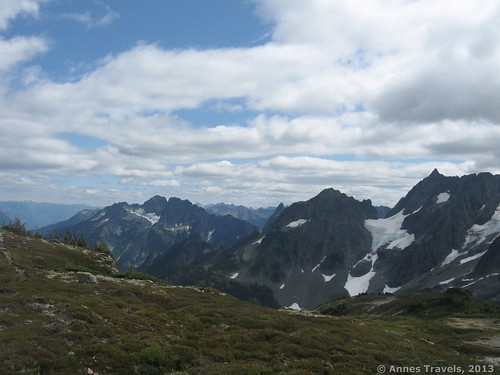
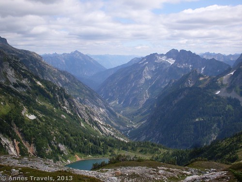
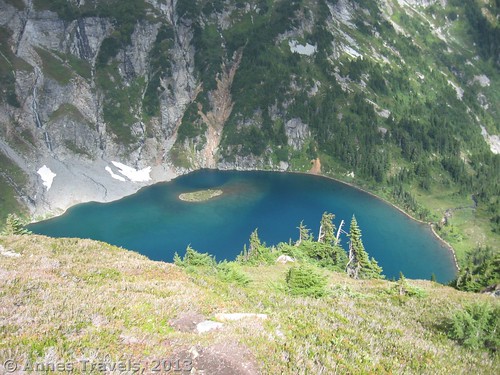
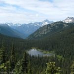
The trail is now much flatter; almost completely flat. The views from here are also sublime. Unfortunately for us, the sun when under soon after we started across the top of the Arm, but we still enjoyed the views. You’re actually walking a fairly narrow ridge, so it’s quite the top-of-the-world experience! We hiked along the flat section to where the trail turns fairly sharply to the right, enters an alpine meadow, and the trail begins to climb again. It was getting a bit late in the day (we had only planned to go up to Cascade Pass, after all), so some of my party turned back. A few of us kept going a half mile (1 km) or so further until a small social trail went off on the right to a lookout over Doubtful Lake. Whatever else you do, don’t miss this view! It’s gorgeous, incredible, jaw-dropping! The blue of the lake augments the green of the surrounding hillsides and the grey of the peaks above to make a beautiful composition, especially with the canyon twisting away from you beyond the lake. Wow! We thought it looked a bit like Middle Earth…Rivendale, or something!
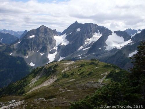
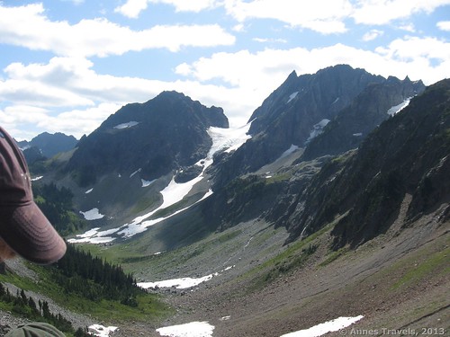
The trail continues up to a glacier. I’d love to go back and go all the way to the end someday, but I had to turn around to get back to the parking area by dark. Apparently, besides the glacier there are also some backcountry campsites…this would be a great place to camp!
Return by the way you came. This is a beautiful trail with awesome views that would make a great long dayhike or an overnight trek. I know I can’t wait to go back!
You can read about my return visit, where I went all the way up to Glacier Camp, here.
Round Trip Trail Length: Up to 11.8 miles (18.9 km)
Facilities: Picnic tables and primitive restrooms at the parking area; sort-of-a-toilet at Cascade Pass…don’t expect to be able to use it, since you’re not supposed to pee in it…
Fees: $5/day. Northwest Forest Pass, America the Beautiful (Interagency), Senior (Golden Age), Access (Golden Access), Volunteer, and Military Passes also accepted
Trail 
![]()
![]()
Road ![]()
Signs
Scenery
Would I go 100 miles out of my way for this?
Overall Rating: 
This Week’s Featured Product!
Looking for more hikes in North Cascades National Park? Check out this book!


5 responses to “Some of the Best Views in the Cascades from Sahale Arm”
[…] Sahale Arm in Washington definitely passes my view snobbery test…! […]
[…] #7) Sahale Arm. Seriously, Sahale Arm is one of the most picturesque of all the hikes I’ve done in the Cascades. Sheltered valleys, waterfall-studded cliffs, awesome peaks…and lovely blue Doubtful Lake beneath it all. Though gravel / dirt, the 20-some mile dirt road is still accessible by low-clearance vehicles. (An updated post with pictures from the end of the trail is coming soon!) […]
[…] out in a sheltered valley. The first time I visited Sahale Arm (this is time #2; you can also read about my first visit to the arm) I thought this valley looked like Tolkien’s Rivendell (not that I’d ever read the book, but […]
[…] Sahale Arm, North Cascades National Park, WA (Here’s our first visit) […]
[…] Arm (probably one of my favorite views ever) after being highly disappointed with the views from Cascade Pass, made it to the top of White Rock via a tangled avalanche chute (really, no one was voluntarily […]