

If you could only do one long hike in North Cascades National Park, I’d recommend the trail up to and along Sahale Arm. It somehow manages to get some of the best scenery in the Cascades into one 13.4 mile trail (RT; you can easily make it shorter; even going 10.5 miles will give you some of the best views) while making those views varied and always awe-inducing. Cascades tumble down sheer cliff faces, jagged peaks tower into the sky, and a lovely blue-green lake nestled in a secluded valley are key features, while the wildflowers themselves (in season) make the trail worthwhile. Perhaps I should stop talking here and just let the pictures tell their own story? Or should I keep talking since the pictures don’t do the view half justice?
Quick Stats
(Affiliate links are present on this page.)
The trailhead is a busy one by North Cascade standards, as the trail passes through Cascade Pass (an extremely popular destination during the summer months) on its way to Sahale Arm. We knew the trail was going to be a very long one, so instead of eating breakfast at the picnic tables at the far end of the parking area, we hit the trail while munching granola bars (chocolate ones – yum!) The trail begins next to the hill, and while it’s not exactly hidden, it isn’t always the easiest to find, either. But if you take a trail uphill, you’re probably in the right place.
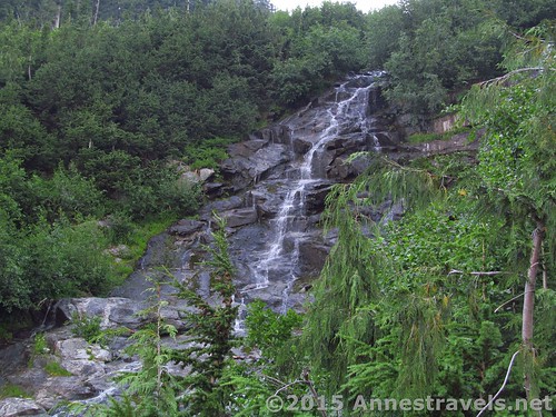
The trail climbs steeply from the first, switchbacking upward through a pine forest. As forests go, this is a nice one. Nothing of excitement comes until just over 2 miles up the trail, where a waterfall runs over the rocks – you’ll have to step off the trail and out into a rocky open spot to see it, but it’s a very quick side-jaunt.
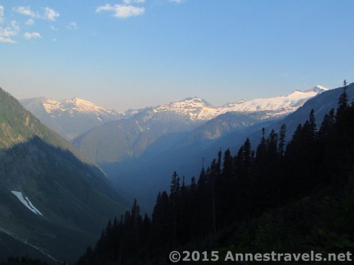
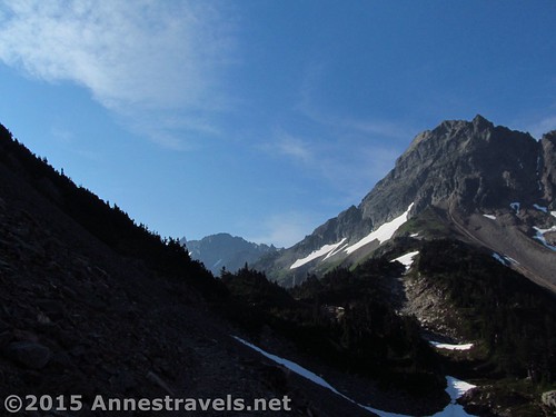
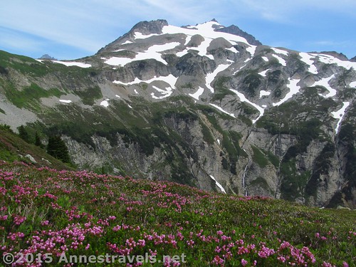
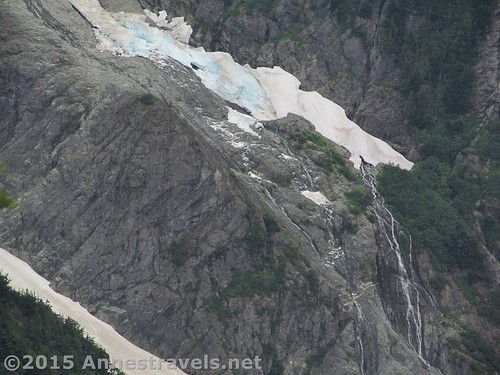
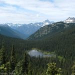
The trail continues to climb through the thinning trees, with peek-a-boo views into the valley you’re leaving. There’s only one word for this valley: stunning! Its waterfalls and peaks are enough to inspire a goodly amount of awe.
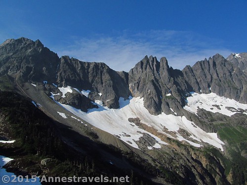
During the last switchback before Cascade Pass (at 4.0 miles), the views open up as the very well-maintained trail traverses a scree field. It’s incredible just how much beauty there is in such rugged spires and the cliffy valley walls. Also be on the lookout for the snowfields – as we descended, later in the afternoon, several of us witnessed an avalanche from these snowfields (and everyone heard it – it sounded like a shotgun going off!)
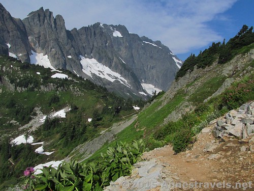
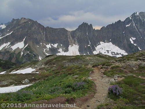
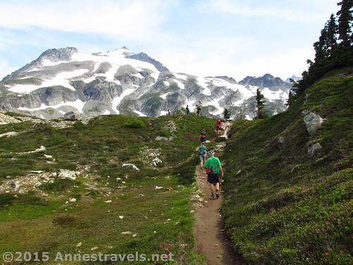
At 4.98 miles, reach Cascade Pass. You can’t possibly miss this, as the trail suddenly turns left and right. (It’s also the place where the views suddenly disappear, as there are a fair number of stubby trees in the pass.) To the right is a primitive toilet as well as a trail down into the next valley. However, for Sahale Arm, turn left. This was where we encountered our first snow in very early August. It’s not hard to find the trail, but you may have to scout a bit if enough people haven’t trampled down the trail through the snow yet. Follow the sign for Sahale Arm at 4.0 miles, coming out on a trail that traverses a rock field while working its way up and around the almost-sheer meadow that is the side of a hill.
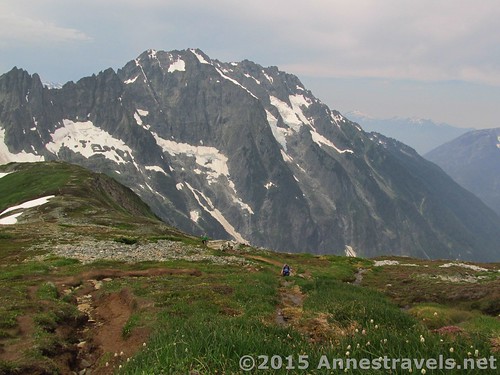
The views from here become more glorious with every switchback. You’re slowly rising out of the valleys and so the view of the valleys – and the surrounding mountains – keeps getting better!
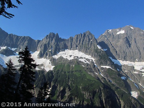
At 4.9 miles, the trail finally tops the hill at the Doubtful Lake Trail Junction. Turn left to continue on Sahale Arm (the Doubtful Lake Trail is less traveled than the Sahale Arm Trail, so wayfinding skills may be necessary if there is still snow on the trail, as there was in early August).

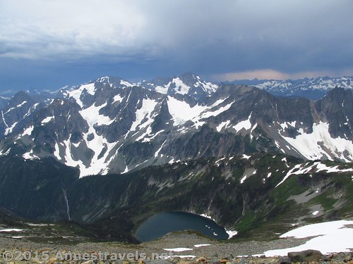
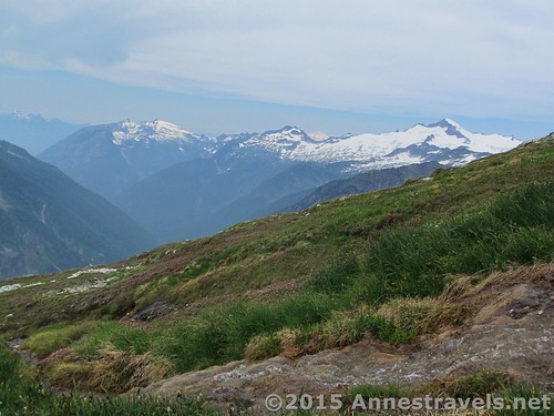
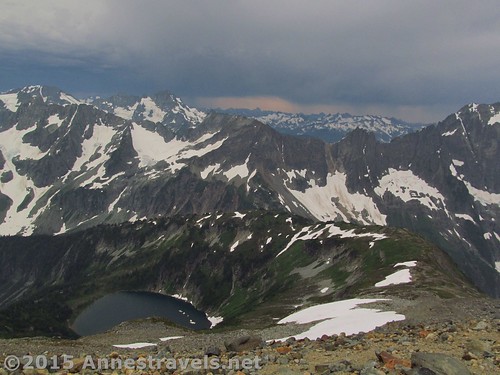
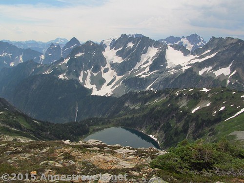
From here on out, you can get glimpses or very good views of Doubtful Lake far below you – a blue / green gem standing out in a sheltered valley. The first time I visited Sahale Arm (this is time #2; you can also read about my first visit to the arm) I thought this valley looked like Tolkien’s Rivendell (not that I’d ever read the book, but other people in my group have, and it looked Middle Earth-ish to me…)
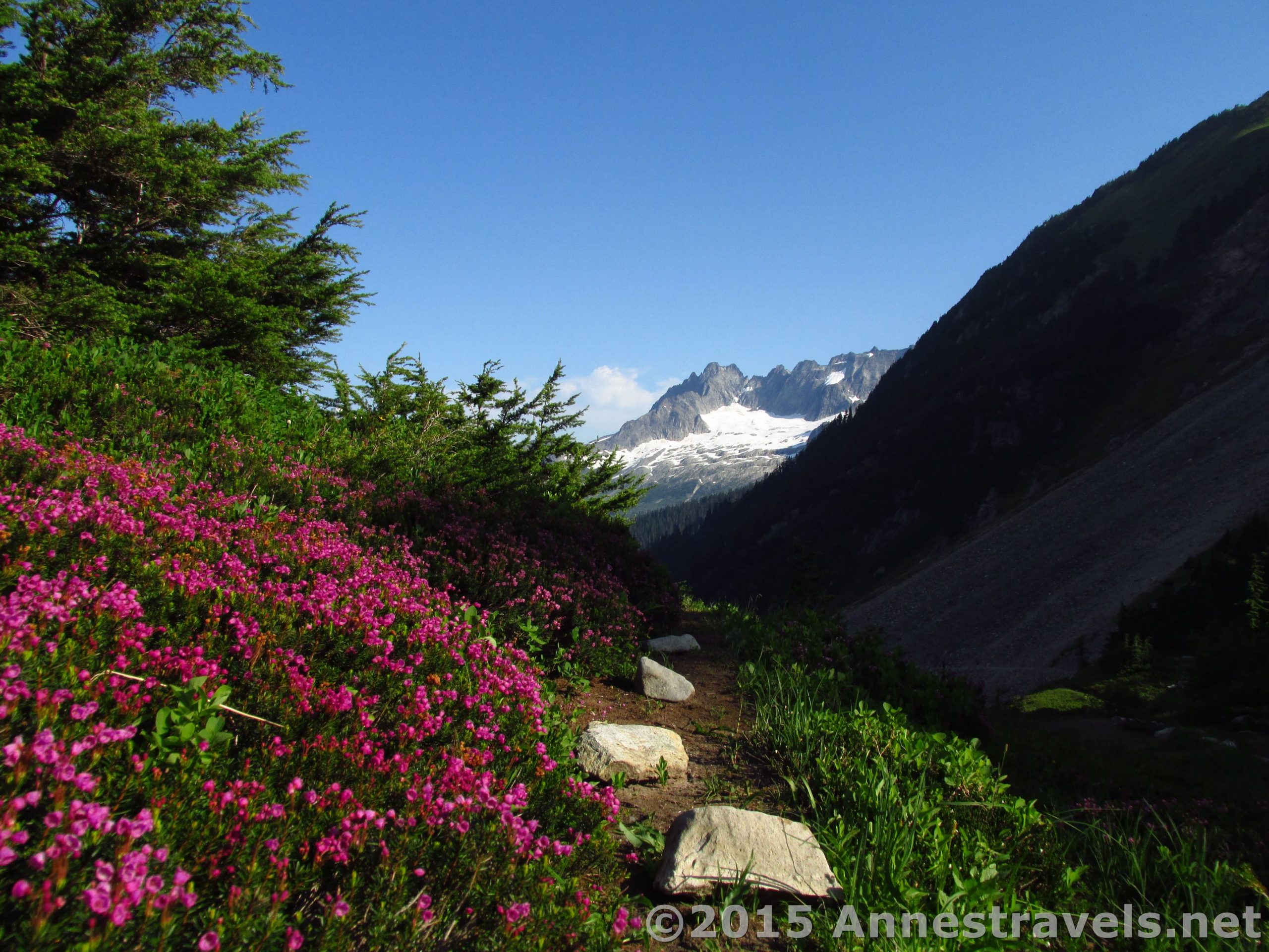
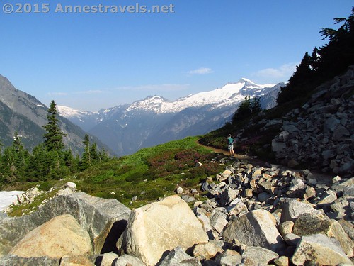
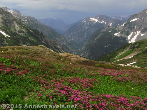
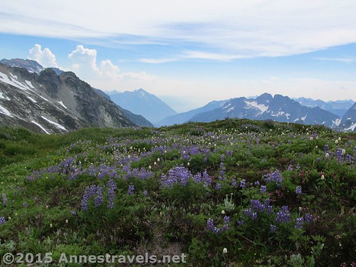
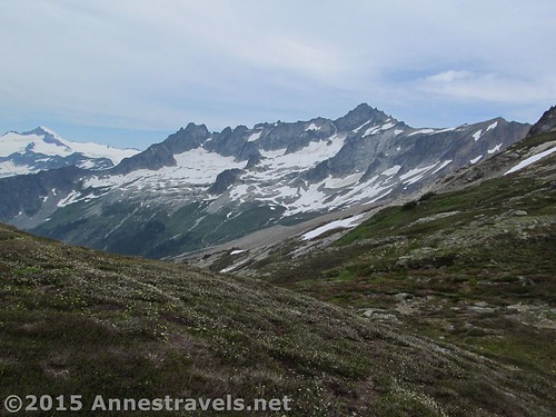
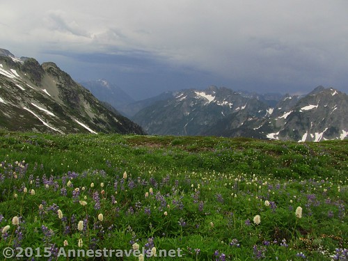
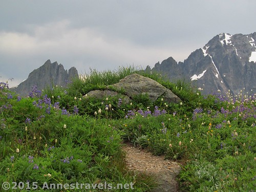
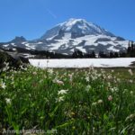
For the next 2 miles, the trail continues to climb slightly or more steadily at times through the almost tundra along the top of Sahale Arm. Grassy and full of heather and wildflowers, there’s never a dull moment, either from the flora or from the ever-increasing views of the surrounding peaks and valleys. You can see up and down about three different valleys, with towering peaks all around. Wow!
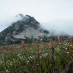
Too bad there were so many fires nearby; the smoke definitely didn’t improve either the pictures or the breathing quality 🙁 The clouds also decided to roll in right about the time we were halfway up the arm, so our pictures became increasingly dark. Oh, well. That makes time #2 for a cloudy hike. I’ll just have to come back again someday when it’s sunny…
At 5.7 miles, a broad, rocky area allows you to look down the valley that you parked in. That’s quite the view!
About 6 miles from the trailhead, the trail suddenly leaves the tundra to enter a rocky path. The best of the views have been seen now, but if you’d really love to see an aerial view, keep going up the very steep, rocky trail the last 0.8 miles to the camp at the top of the arm.
The views from here were fantastic, even though a thunderstorm seemed to be blowing through (at least, the clouds and ice pellets were blowing in!) Doubtful lake, myriads of peaks, peaceful valleys; everything you’ve seen along the arm and more!
By this point we were all pretty tired – almost half of the group had turned around at the rocky section, figuring the faster hikers would make it to the top and still pass them before the bottom of the trail (ok, before the Doubtful Lake junction). Still, I was glad to have made it all the way to the top!
Coming back down through the clouds and thankfully-no-real-rain, there was a misty, unreal quality to Sahale Arm and everything around it. Still, the mist didn’t stop me from taking pictures…and who wouldn’t in such a gorgeous spot as this?
In Cascade Pass, we met a park ranger, ready to answer any and all questions. Our only real one was, “How do you pronounce the name of the arm up there?” The answer? “Sa-HAL-ee” (with all the a’s sounding like the a in father). Oh, well, there went our “Se-HAIL” pronunciation! And after the ice pellets, you’d think that Hail would be about right!
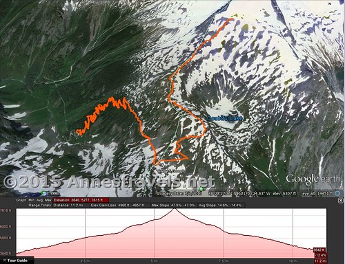
Round Trip Trail Length: 13.4 miles
Lowest Elevation: 3,592ft. (parking area)
Highest Elevation: 7,581ft. (camp at the top of Sahale Arm)
Net Elevation Gain / Loss: 3,989ft.
Facilities: Primitive restrooms and picnic tables at the trailhead
Fees: None
Trail 
![]()
![]()
Road ![]()
Signs ![]()
Scenery
Would I go 100 miles out of my way for this?
Overall Rating: ![]()
Key GPS Coordinates for Sahale Arm
Sahale Arm Parking: 48.47529N / -121.07531W (48° 28′ 31.044″ / -121° 4′ 31.116″) (3,592ft.)
Trail beginning: 48.47540N / -121.07494W (48° 28′ 31.44″ / -121° 4′ 29.7834″) (3,618ft.)
Waterfall view: 48.47913N /- 121.06900W (48° 28′ 44.8674″ / -121° 4′ 8.4″) (4,577ft.)
Cascade Pass: 48.46758N / -121.05905W (48° 28′ 3.2874″ / -121° 3′ 32.5794″) (5,345ft.)
Sahale Arm Trail Junction: 48.46895N / -121.05863W (48° 28′ 8.2194″ / -121° 3′ 31.0674″) (5,356ft.)
Doubtful Lake Junction: 48.47066N / -121.05180W (48° 28′ 14.376″ / -121° 3′ 6.48″) (6,053ft.)
Valley View: 48.47727N / -121.05724W (48° 28′ 38.1714″ / -121° 3′ 26.0634″) (6,516ft.)
Beginning of the scree: 48.48072N / -121.05275W (48° 28′ 50.5914″ / -121° 3′ 9.9″) (6,700ft.)
Top (camp): 48.48516N / -121.04539W (48° 29′ 6.576″ / -121° 2′ 43.4034″) (7,581ft.)
The gpx file for Sahale Arm can be downloaded – please note that this and the GPS Coordinates are for reference only and should not be used as a sole resource when hiking this trail.
GPX Download File size: 311.1 KB Downloaded 559 times
(Note: I do my best to ensure that all downloads, the webpage, etc. are virus-free and accurate; however, I cannot be held responsible for any damage that might result, including but not limited to loss of data, damages to hardware, harm to users, from use of files, information, etc. from this website. Thanks!)
Getting to the Sahale Arm Parking Area
From Marblemount on Route 20, take Cascade River Road 23.1 miles (37.1 km) until it ends in the Cascade Pass parking area. (In other words, after you cross the river just to the east of Marblemount, keep going straight when Route 20 takes a hard turn to the left; drive to the end of this road.) The road is paved for the first 8-10 miles (12-16 km), then becomes gravel (a low-clearance vehicle could have easily driven it when we visited in early August; I saw several at the trailhead). The road usually opens in June or July (depending on snow cover) and closes in the early fall due to snow. However, you could snowshoe it or even cross-country ski it while it’s under snow.
Zoom map out to browse nearby hikes & places of interest
This Week’s Featured Product!
This is an excellent resource for day hiking in Washington, with many trails to explore. It also covers a variety of areas in depth, including North Cascade National Park and Mt. Baker.


9 responses to “Sahale Arm Revisited: Incredible Views!”
[…] example of just what the 160 can do. This was in Cascade Pass, North Cascades National Park, […]
[…] Sahale Arm. This is probably my favorite North Cascade hike ever – and I’ve never had decent weather to hike it in. Still, the views even without sunshine made my jaw drop – so many peaks, so many valleys, so many sheer cliffs, Doubtful Lake down below. I didn’t have breath to spare, and wasn’t sure if it was the elevation or the views. At least 10.5 miles RT, although 13.4 miles RT will take you all the way up to Sahale Camp/Galcier. […]
[…] Atop Sahale Arm, North Cascades National Park in […]
[…] Sahale Arm (revisited), North Cascades National Park, Washington. I don’t know about anyone else, but Sahale Arm is one of the most spectacular trails I’ve taken in North Cascades National Park (rivaled only by nearby Hidden Lake Lookout Trail). Both times I’ve hiked it, the clouds have rolled in, but that hasn’t stopped my jaw from dragging on the ground the whole way, up and down! 9.8 miles to 13.4 miles with up to 3,989 ft. elevation gain. […]
[…] Sahale Arm, North Cascades National Park, WA (Here’s our first visit) […]
[…] You can read about my return visit, where I went all the way up to Glacier Camp, here. […]
[…] from Sahale Arm, North Cascades National Park, […]
[…] lakes, and valleys from Sahale Arm in North Cascades National Park, […]
[…] Or you can keep pressing forward (my preferred approach, apparently – that’s how we discovered Sahale Arm (probably one of my favorite views ever) after being highly disappointed with the views from […]