
Often, the reason the lesser-known parts of national parks are lesser-known is because they aren’t worth seeing. Or at least, they’re not as nice as the better-known parts. But that simply isn’t true of the northwest section of Mt. Rainier National Park. I wish I’d had more time to explore it, but the road into the area and Spray Park were out-of-this-world beautiful. Beyond Mt. Rainier – which was just stunning – the nearby peaks were also nice, and the meadows full of wildflowers added to the beauty. There was still a fair amount of snow in early August (and that after a warmer than average summer), but it didn’t stop us from tramping up the trail to the best view of Rainier – right as the clouds covered the summit! Still, I’d highly recommend the trail and the views to anyone in the area who can make it through some rougher terrain on a decent trail.
Quick Stats
(Affiliate links are present on this page.)
My biggest hesitation about visiting Spray Park was – of all things – that I couldn’t find a lot of information on the internet. I knew the trail existed, but how long was it? And please, what on earth does it look like? I finally found enough to convince me we could do it (and it would be worth doing) but I was still a bit nervous that we were driving so far out of our way for this. It turned out ok, though: Spray Park was a high point of the trip!

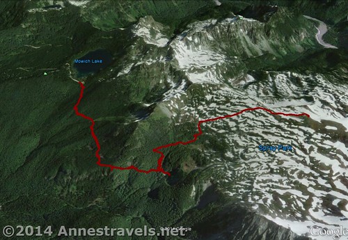
We arrived in the very early morning. We’d slept in the national forest outside the park (be very careful not to sleep on private property – which is just about everywhere – on the drive in), but there is also a campground at the trailhead. Even with the large parking area, the lot was nearly full and would be a lot fuller before the day was over. We quickly packed up our gear, used the restrooms, and headed around the restrooms and to the right just before the campground proper to the slightly obscure Wonderland Trail (it’s really not that hidden, but it’s easy to miss, too).
The trail immediately begins to descend; after only 0.2 miles, turn left toward Spray Park – here you leave the Wonderland Trail. For the next 1.4 miles aren’t particularly interesting, rolling gently through the forest. At 1.6 miles, you can turn right down a short trail to the Eagle Cliff Viewpoint. I highly recommend the viewpoint, as the views from there are really quite awesome of Mt. Rainier, though they’d be better in the afternoon than the morning.
Continuing down the trail, be careful to take a left toward the “water” rather than Eagle Camp a little less than half a mile beyond the viewpoint. After this, the trail crosses a variety of small streams will some lovely waterfalls.

We’d read about a junction for a waterfall but figured these small ones were about it until we got to the waterfall junction at mile 2.25. Turning right (why not, right?) we hiked about 0.1 miles to the edge of a larger river with a nice little waterfall. “How nice,” I thought. Then I stepped out on the rocks on the edge of the river and saw this:
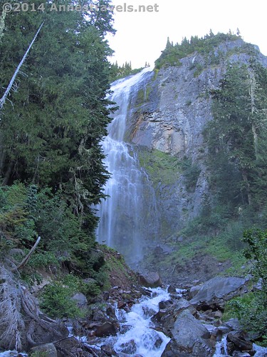
Oh! A real waterfall! I guess I live too close to Niagara Falls to “fall” in love with the little trickles. It was so funny to sit there and watch people’s faces as they saw the real thing for the first time. If you really want to see the waterfall, you’ll have to cross the slippery logs to the other side of the river, then scramble up the even slipperier stones to a place where you can see it. Worth doing if you’re in really good shape, otherwise, the view on this side of the river is fine.

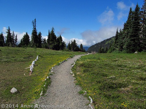
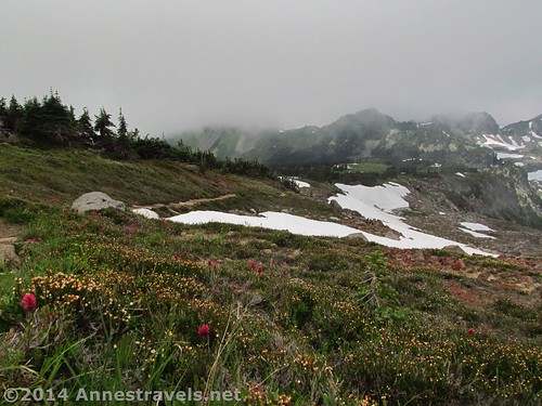
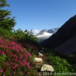
Returning to the Spray Park Trail, the trail began a steep ascent through the forest. There still weren’t any views and it didn’t seem like there would be any more soon. However, right around 3 miles, the trail suddenly leaves the trees and enters Spray Park. From here on out, there are views of one kind or another almost the entire way up to the high point on the trail.
Looking up on the ridge to the left not long after entering the park, we (and some other hikers) spotted about four bears – a male and a female with two cubs. Pretty cool!

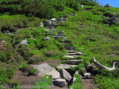
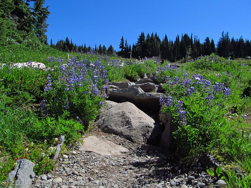
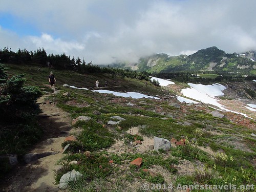
The trail winds through the park (watch out for the bugs, which are pretty bad) through lovely meadows and stands of trees. There are peek-a-boo views of Mt. Rainer, which keeps getting nicer the further you hike.
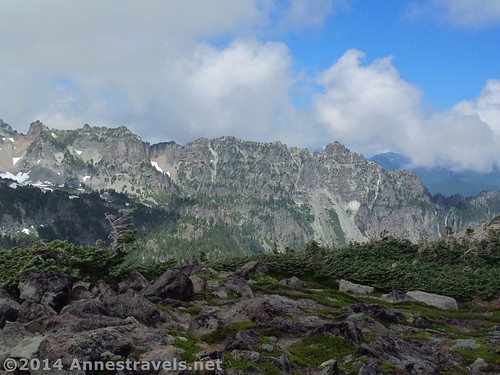
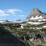
Even when Mt. Rainier isn’t in sight, there are often views of the surrounding peaks and ridges.
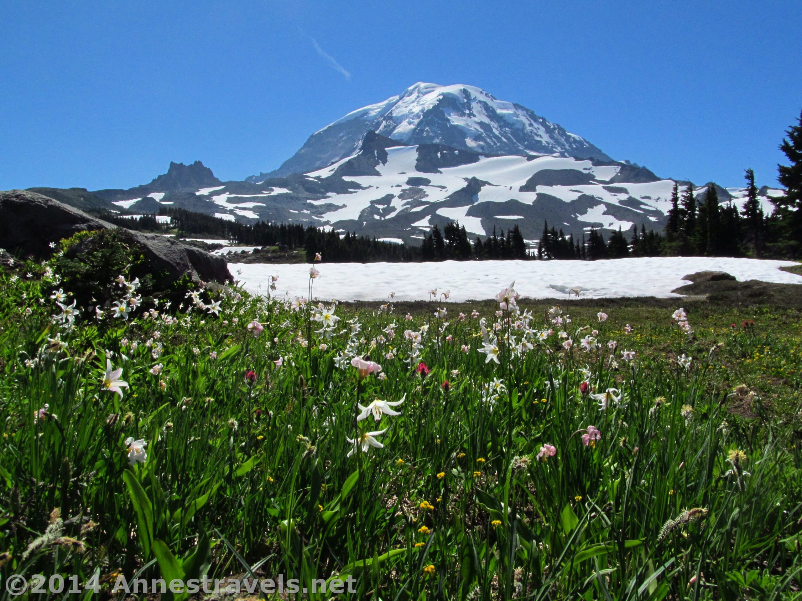
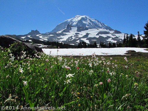
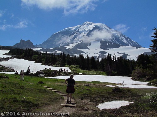
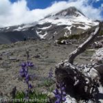
About this time, we discovered that there were clouds working their way up the valley toward Mt. Rainier, so we really began to boogie up the trail. We had no idea where we were going (exactly) but we wanted to see as much of the trail as we could before the clouds got to the mountain. One nice view was about a half a mile into Spray Park – if you don’t go any further than this, you really should get a good view of Mt. Rainier through an open meadow.
Other views of Rainier open up, too.
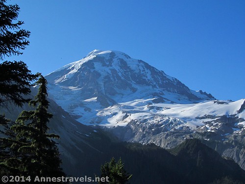
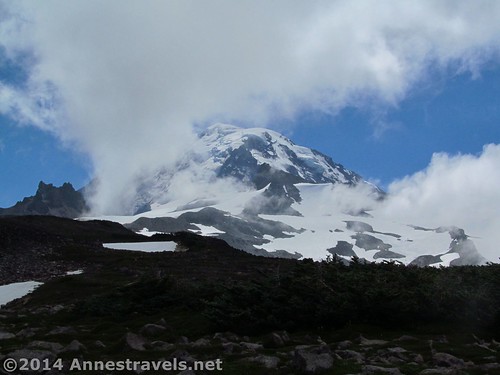
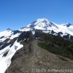
Very suddenly, right around mile 5, the trail leaves the lushness of the meadow and enters a rock field. The trail also begins to climb. We went to the end of where it climbed, then, as it began to descend, we turned right onto a well-defined social trail that continued to ascend a small, rocky hill. From the top of this hill is the most magnificent view of Mt. Rainier. Unfortunately for us, the clouds decided to arrive right at this point, so we didn’t get to appreciate the view as much as those before us. That said, it just got worse as the day went on, so we were so glad for the good view that we had!
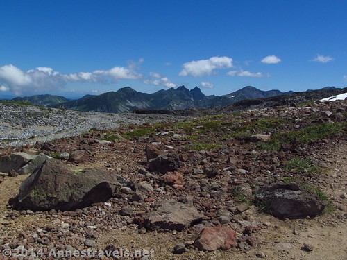
Really, it’s the views from this little hill that make Spray Park worthwhile. Beyond Mt. Rainier (which, as I said, is magnificent) there are so many other peaks and ridges around you. We spent quite some time waiting for the clouds to roll away (they didn’t) so we also spent quite a bit of time looking at the rest of the view (which wasn’t in clouds for some reason).
Return the way you came, or you could continue along the top of this hill on the social trail for quite some distance. I’d love to do that on a nicer day!
Round Trip Trail Length: About 9.5 miles
Lowest Elevation: 4,815 ft.
Highest Elevation: 6,416 ft.
Net Elevation Change: 1,601ft.
Facilities: Campground, primitive restrooms, and garbage pickup at the trailhead
Fees: $15 per vehicle, valid 7 days. America the Beautiful (Interagency), Senior (Golden Age), Access (Golden Access), Volunteer, Military, and Mt. Rainier Annual Passes also accepted – National Forest Pass and Discovery Pass NOT accepted.
Trail 
![]()
![]()
Road ![]()
![]()
Signs
Scenery
Would I go 100 miles out of my way for this?
Overall Rating: ![]()
Key GPS Coordinates for Spray Park

Mowich Lake Parking Area: 46.93333N / -121.86454W (46° 55′ 59.9874″ / -121° 51′ 52.344″) (4,883ft.)
Campground Entrance: 46.93300N / -121.86413W (46° 55′ 58.7994″ / -121° 51′ 50.868″) (4,924ft.) (ended 9.6)
Trail beginning: 46.93257N / -121.86331W (46° 55′ 57.2514″ / -121° 51′ 47.9154″) (4,921ft.) (300 ft.)
Spray Park / Wonderland Trail Junction: 46.93024N / -121.86289W (46° 55′ 48.8634″ / -121° 51′ 46.4034″) (4,815ft.) (0.2)
Eagle Cliff Viewpoint Trail Junction: 46.91642N / -121.85341W (46° 54′ 59.112″ / -121° 51′ 12.2754″) (4,947ft.) (1.6)
Eagle Cliff Viewpoint: 46.91620N / -121.85347W (46° 54′ 58.32″ / -121° 51′ 12.492″) (4,921ft.) (1.7 – 100 ft. from trail)
Eagle Camp / Waterfall Junction: 46.91579N / -121.84721W (46° 54′ 56.844″ / -121° 50′ 49.956″) (4,888ft.) (2.0)
Waterfall Trail Junction: 46.91609N / -121.84495W (46° 54′ 57.9234″ / -121° 50′ 41.8194″) (4,880ft.) (2.25)
Waterfall: 46.91547N / -121.84338W (46° 54′ 55.6914″ / -121° 50′ 36.1674″) (4,837ft.) (2.4)
Enter Spray Park: 46.91906N / -121.84111W (46° 55′ 8.616″ / -121° 50′ 27.996″) (5,452ft.) (6.79 on the way back)
Nice view: 46.92299N / -121.82892W (46° 55′ 22.7634″ / -121° 49′ 44.1114″) (5,990ft.) (3.4)
Left the trail: 46.92150N / -121.81877W (46° 55′ 17.4″ / -121° 49′ 7.572″) (6,350ft.) (5.1)
Top view: 46.92090N / -121.81860W (46° 55′ 15.24″ / -121° 49′ 6.96″) (6,416ft.) (5.1)
The gpx file for Spray Park can be downloaded – please note that this and the GPS Coordinates are for reference only and should not be used as a sole resource when hiking this trail.
Download File size: 203.4 KB Downloaded 512 times
(Note: I do my best to ensure that all downloads, the webpage, etc. are virus-free and accurate; however, I cannot be held responsible for any damage that might result, including but not limited to loss of data, damages to hardware, harm to users, from use of files, information, etc. from this website. Thanks!)
Driving Directions to Spray Park
From Puyallup, WA, take WA-512 E onto WA-167 N, then onto WA-410 E. These are in fairly quick succession, so keep an eagle eye out for the exits. Drive 10.7 miles on WA-410 E. Turn right onto Mundy Loss Road and drive 1.2 miles; turn left onto WA-162 E. After 0.2 miles, continue straight onto WA-165 S for 25.2 miles to the end of the road at Mowich Lake. You will pass through a fair amount of private wilderness land with signs everywhere about it being posted, no hunting or camping allowed. Still, the views are awesome in places!
Alternatively, from Enumclaw, WA, drive southwest on WA-410 W. About 4 miles from Enumclaw, you’ll want to turn left onto WA-165 S. Stay on WA-165 S for not quite 1.5 miles; turn left to stay on WA-165 S for 25.2 miles to the trailhead at Mowich Lake.
Road Note: The road to Spray Park is dirt. It’s perfectly passible for high clearance and shouldn’t be an issue for even low clearance vehicles (there were plenty compact cars at the trailhead among the jeeps, SUV’s, and pickups).
Zoom map out to browse nearby hikes & places of interest
This Week’s Featured Product!
This book has quite a few trails in Mt. Rainier National Park as well as hikes in other nearby areas. Enjoy the photography and trail descriptions.
7 responses to “Lovely Mt. Rainier Views from Spray Park”
[…] Spray Park in Mt. Rainier National Park, […]
[…] Spray Falls, Mount Rainier National Park, Washington. This falls isn’t the easiest to get to if you actually want to see more than a group of pine trees, but by crossing the river, the size and magnificence takes your breath away. Visit in the afternoon for better lighting. And the great thing is that the trail to the falls has numerous little waterfalls along it, making for a double-great hike! 4.8 miles RTBonus Waterfall! Myrtle Falls, Paradise Area, Mount Rainier National Park, Washington. A lovely little falls below stunning meadows and incredible views of Washington’s only 14er. About 1 mile RT […]
[…] Spray Park. Relatively few people check out the northwest area of Mt. Rainier National Park, but those who do and who take a hike aren’t disappointed. Spray Park showcases Mt. Rainier as well as wildflowers (and wildlife!) of all kinds. 9.5 miles RT. […]
[…] list of my favorite hiking websites. The picture is of hiking through the upper reaches of Spray Park in Mt. Rainier National […]
[…] in Spray Park, Mt. Rainier National Park, […]
[…] en route to Spray Park in Mt. Rainier National Park, […]
[…] 13. Spray Park, Mount Rainier National Park, Washington. This area of Mt. Rainier isn’t as popular as Paradise, but it’s no less on its views. Get above the park for some truly epic views of Washington’s only 14er. […]