
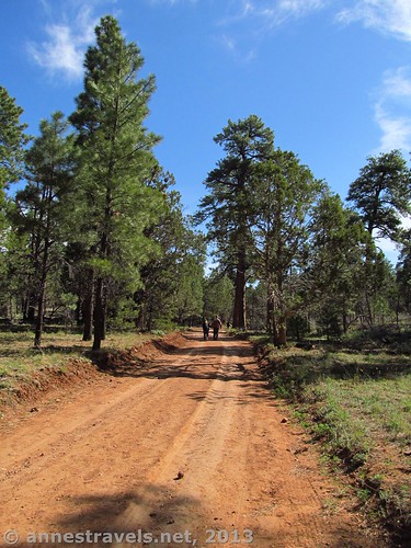
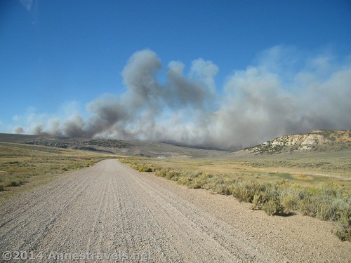
I can’t say I travel to get to the dirt roads. But when that’s all that is between me and a lovely I hike I want to take, let’s just say I’m very willing to tackle the road. Some are short – an access road to a trailhead – while others stretch on for mile after mile of bone-jarring, jolting potholes and washboard. My waterloo? 4×4 roads. The van has non-slip (which has gotten us out of more than one scrape, in the desert and on snow), but it balks at sand, mud, and drops that were never intended for a 2×4 vehicle. Anyway, I thought I’d put together a list of some of the sights I think are worth seeing but that are quite a ways down a dirt road…more than 10 miles, in fact!
(Affiliate links are present on this page.)
Some of these 10-miles-down-a-dirt-road are little worse than a poor blacktop road, but others you might want to think twice about if you value your vehicle’s longevity…
So here they are, from shortest to longest…enjoy!
12 Places Worth Visiting at Least 10 Miles Down a Dirt Road
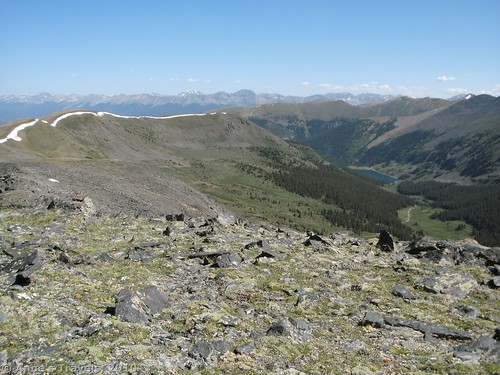
#1) Tincup Pass. Exactly how far Tincup Pass is from a paved road is a bit sketchy in my mind, but I think it’s safe to say the remote pass in Colorado is 10 miles from a paved road. Actually, that’s one of the things I loved about hiking the peaks around the pass: you can’t see any paved roads, either, even though the views stretch for miles in all directions. This road isn’t for the faint of heart, though: Last time I visited, there was no way you could get to the pass without 4×4, and even that wouldn’t help a jeep get around snowbanks that still clung to the pass on the 4th of July. We walked.
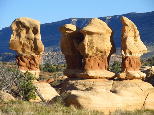
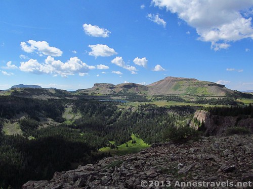
#2) Devil’s Garden. If you like Utah rock formations, you have to go to Devil’s Garden in Grand Staircase-Escalante National Monument. Seriously. Only 12 miles down the spectacular Hole In The Rock Road, even compact cars can (usually) make it to the parking area. Those who hang on over the jarring washboard are rewarded with fantastic formations, sandstone pillars, arches, and more. Just before sunset, the formations become even more awesome as the sun turns the yellow and orange rock a golden hue.
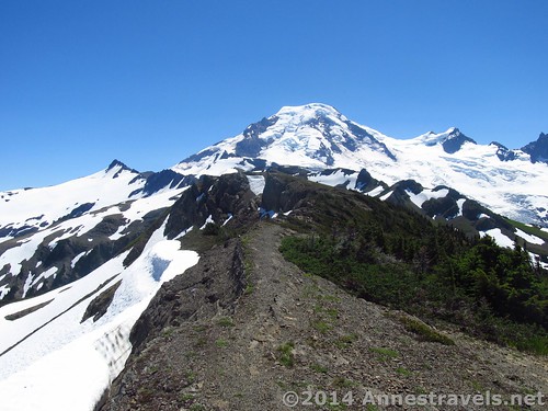
#3) Skyline Divide (post coming soon!). Then, there’s Skyline Divide. It has to be one of the most impressive views I’ve seen in Washington state, and that’s saying a lot (especially with Ptarmigan Ridge quite close by). The trailhead is at the end of a fair conditioned 13-mile dirt road (accessible to low-clearance cars that don’t mind a bit of adventure), and the first couple miles through the trees are both uninteresting and nothing to sneeze at in terms of elevation gain. But once you reach the ridge, the views keep getting better and better…especially if you walk for a few miles!
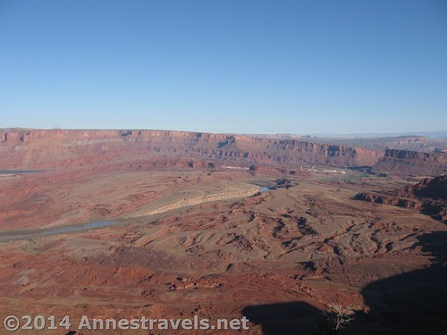
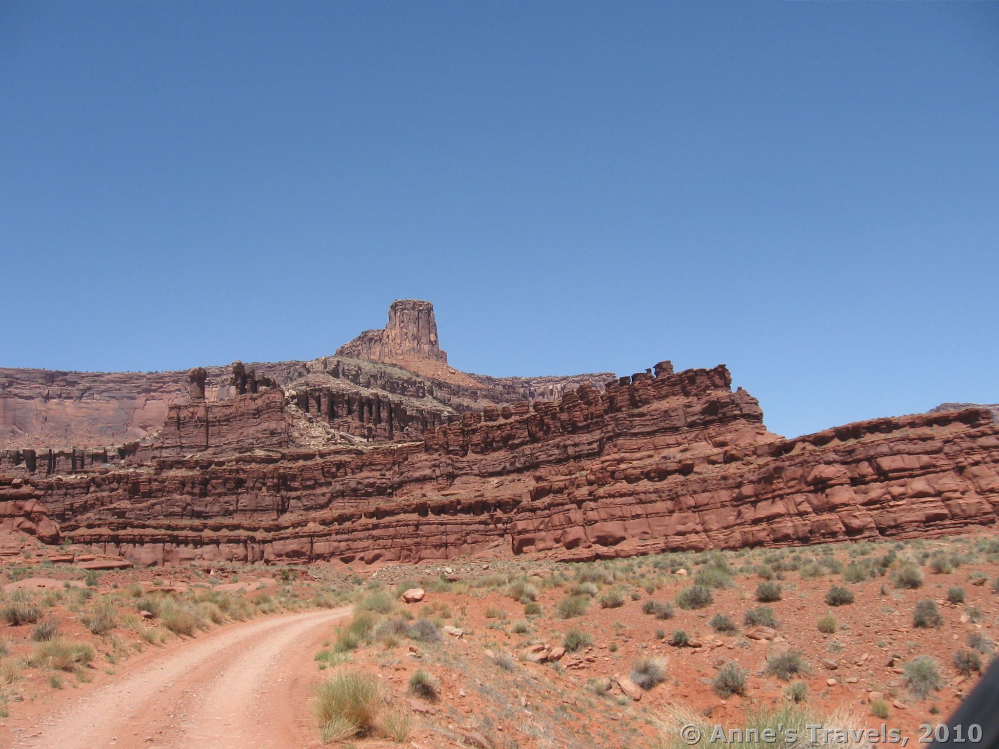
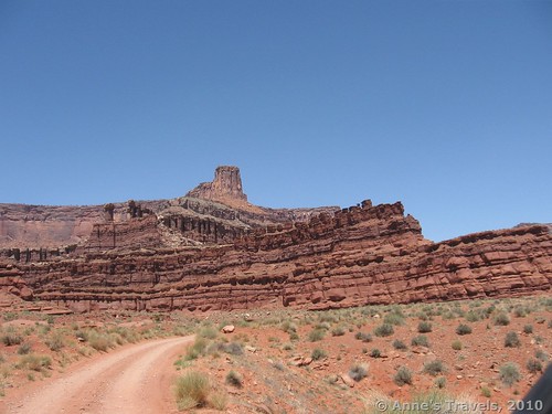
#4) Anticline Overlook. To me, Canyon Rims Recreation Area is one of the best hidden gems in the Moab area of Utah. Although there are several overlooks (including one on a paved road), Anticline Overlook continues to be one of my favorites, showcasing classic Utah scenery, a crazy jeep road, the Colorado River, and even a potash factory. The 16 miles of dirt / gravel road is usually fully accessible for most vehicles.
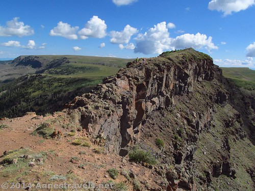
#5) The Causeway. If you love the art of Andrew Wyeth, you’ll love the area surrounding the Causeway in northwestern Colorado. Alpine meadowlands stretch for miles in a pastoral panorama, very similar to Wyeth’s “Christina’s World”…until it hits a cliff edge with awe-inspiring sheer drops to pristine lakes below. A little over the top description? Yep. But it’s still beautiful. The 17 or so miles to the trailhead are gravel / dirt, so they’re accessible even to low-clearance vehicles and horse trailers.
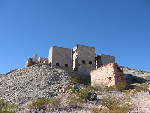
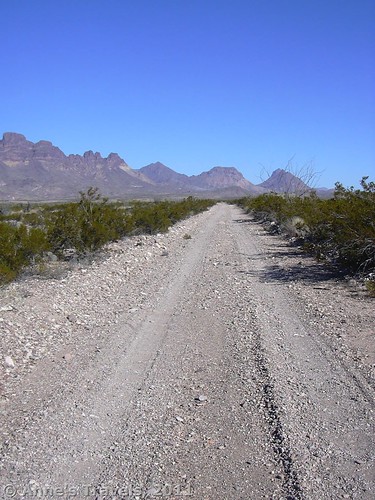
#6) Mariscal Mine. Mariscal Mine is a bit one-of-a-kind. Once a mercury mine and refinery, today it’s just a skeleton…but a rather fine specimen at that. Sure, you’ll have to drive at least 19 miles of the very rough River Road (high clearance a necessity) through the south of Big Bend National Park (sometimes less than miles from the Mexican border), but the incredible scenery makes the drive to the mine worthwhile (and for peaceful campsites, it’s hard to beat the primitive ones along the River Road!)
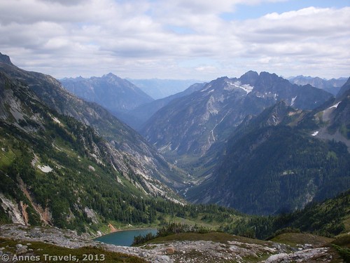
#7) Sahale Arm. Seriously, Sahale Arm is one of the most picturesque of all the hikes I’ve done in the Cascades. Sheltered valleys, waterfall-studded cliffs, awesome peaks…and lovely blue Doubtful Lake beneath it all. Though gravel / dirt, the 20-some mile dirt road is still accessible by low-clearance vehicles. (An updated post with pictures from the end of the trail is coming soon!)
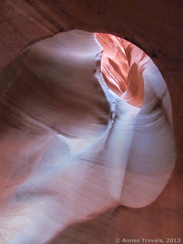
#8) Slots of the Dry Fork of Coyote Gulch. If you’ve never hiked a slot canyon (or even if you have), Peek-a-Boo and Spooky Slots are two of my favorites ever (and I love slot canyons!) The arches and delicate curves of Peek-a-Boo and the claustrophobic narrowness of Spooky make both a worthwhile stop…if you don’t mind jiggling down 26 miles of dirt roads in the wilderness of Utah, then leaving all but 4×4 vehicles behind for the last 0.25 miles or so to the trailhead as the road is rather washed out. Still, I enjoy them both and always have fun trying (and not succeeding) to not walk sideways through the Spooky narrows!
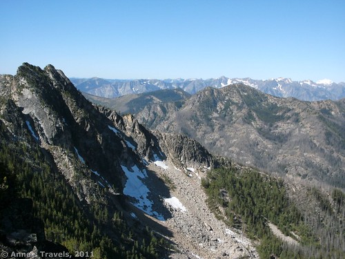
#9) Summer Blossom Trail. OK, so Summer Blossom isn’t well-known in Washington. It also accidently turned into a 15-ish mile trail when it should have been 3 miles RT. But that was because I loved the scenery so much I lost track of the miles. Or something like that. Anyway, even hiking to Deadman Pass is worth the 30 miles of rough dirt roads (high clearance recommended) and vague directions to see…especially if the summer really does blossom.
#10) Wall Lake Trail to Amphitheatre Peak. The road to the trailhead for Amphitheatre Peak isn’t bad as dirt roads go, but the trail doesn’t go up the peak…so if you want those lovely views of Trapper’s Lake (nicknamed “The Cradle of the Wilderness”) you’ll have to drive well over 45 miles on an unpaved road (low-clearance generally acceptable), then strike off-trail to the summit. The views are rewarding, though.
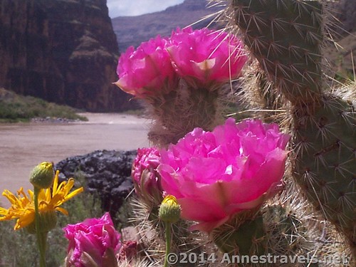
#11) Lava Falls Trail. OK, so it’s the only rim-to-river route in the Grand Canyon you can safely do in a day, even if the trail is more of a route than a groomed trail. Still, the Lava Falls Trail (3 miles RT, but a full-day adventure) is a once in a lifetime experience…if you can survive the 60 mile dirt road to the trailhead (and scrambling down a scree-filled chute…surfboarding skills an asset).
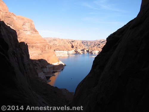
#12) Hole in the Rock. If you really want a dirt road adventure, going to Hole in the Rock is an enjoyable way to do it, with a really cool scramble at the end of the road (all the way down a narrow canyon to Lake Powell). The “Hole” was created by Mormon settlers trying to reach the creek bottom that is now many feet below the surface of Lake Powell. The road, though, is a definite adventure: for the first 15 to 25 miles or so, the Hole In The Rock Road is accessible to cars; from there, you’re much better off with high clearance, and 4×4 is likely the only way you’ll reach the end of the road at the Hole in the Rock (the last 5 miles or so are outside national monument and can be greatly worse than the rest of the road). But the 62 mile bone-jarring, jerky trek is worth it…if you think your vehicle can handle it…
Always remember to take proper precautions on dirt roads, like driving slowly, filling up on gas before driving, and taking plenty of food and water, as well as knowing life-saving skills…most of these dirt roads are in the middle of the wilderness many, many miles from help of any kind!
Zoom map in to browse individual hikes
This Week’s Featured Product!
As much as none of us want to think about it, accidents do happen when we’re traveling in the wilderness…from cuts and blisters to life-threatening heart attacks and broken bones. This book is rated one of the best for diagnosing, treating, and preventing wilderness medical emergencies.


One response to “12 Places Worth Visiting at Least 10 miles Down a Dirt Road”
[…] 12 Places Worth Visiting at least 10 Miles down a Dirt Road. I don’t exactly take dirt roads for the view (although there are plenty on the right dirt roads), but such unimproved roads are often the gateway to hikes with some of the best scenery in America… in my opinion, at least. […]