

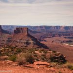
Anticline Overlook is probably my favorite overlook of all the viewpoints in Canyon Rims National Recreation Area (other favorites are the Needles Overlook, Minor Overlook, and Canyonlands Overlook). It offers several views of spectacular scenery, from canyons and rock formations to the Colorado River and the La Sal Mountains – in only half a mile. Its biggest downside is that it’s at the end of a very long (only 6.4 miles, but it feels much longer) gravel road. So chances are this place won’t be overrun when you visit. But it is low-clearance accessible, and given the views, it’s well worth the drive if you happen to have a few free hours and you’re in Moab or the surrounding area.
Quick Stats
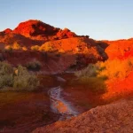
I happened to visit at a truly spectacular time of day – late afternoon in October. The angle of the sun is perfect for fabulous photos and enjoying the cliffs that seem to glow in the sunshine. I’ve also visited in the early morning, and that’s great for views into the canyons to the west. So you really can’t go too wrong.
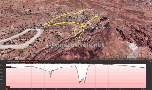
The path begins next to the registration box (you can also start near the sign, on the path lined with stones that passes by the picnic area, but I decided to do the right side of the loop first and hike counterclockwise). The path is easy to follow as it wanders across the desert to the canyon rim.

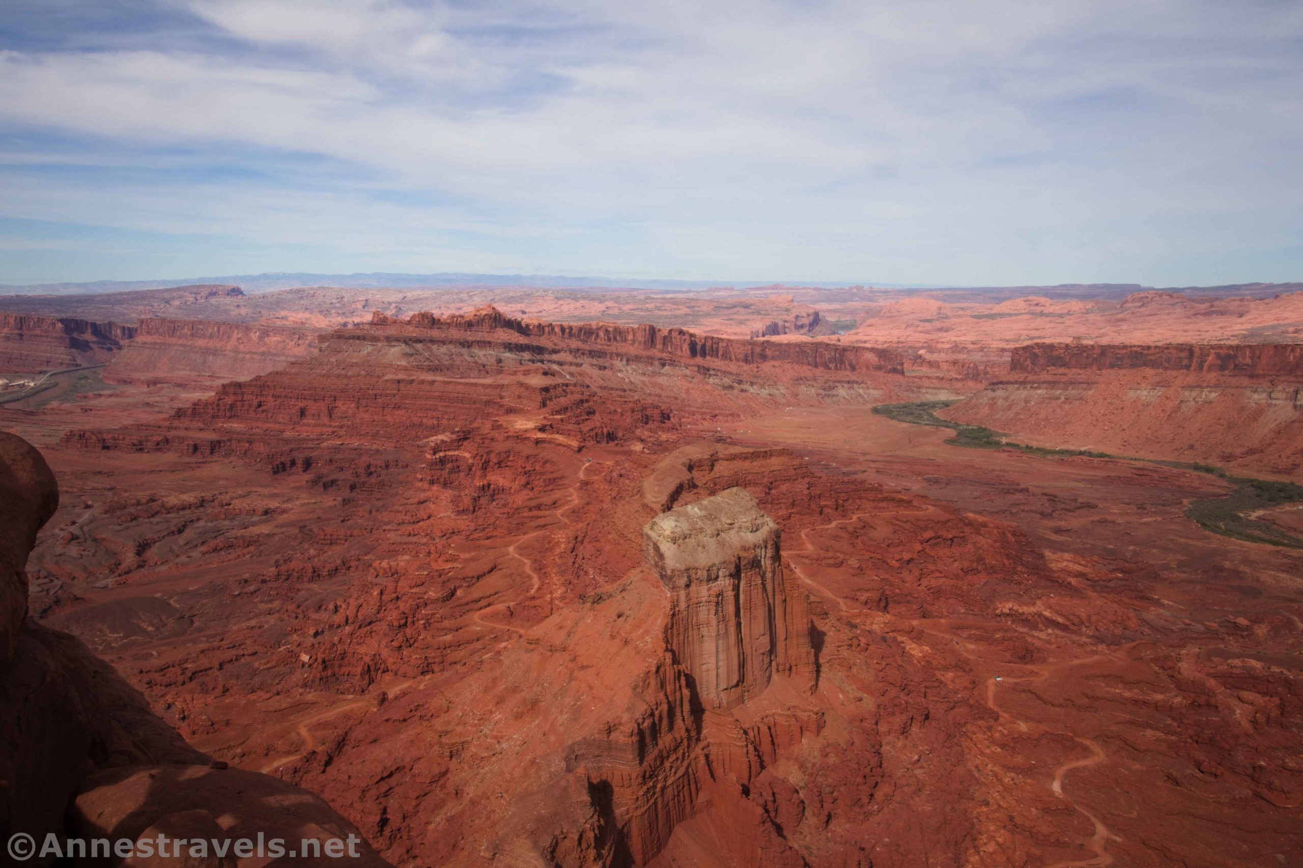
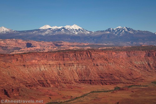
There are four different viewpoints at Anticline Overlook. Every one is worth seeing. To get to the first viewpoint, you’ll need to turn right after about a tenth of a mile and descend (it’s pretty easy to see where to go). The views up the valley and toward the La Sal Mountains took my breath away!

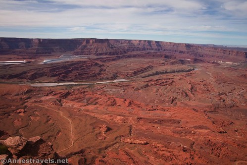
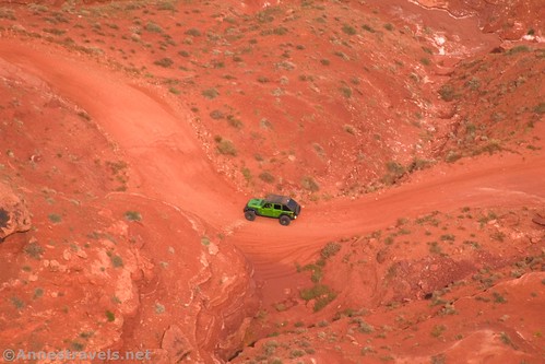
Continuing along the path, Viewpoint 2 is about a tenth of a mile later. Keep your eyes open for OHVs on the road below (Kane Springs Road, among other names).
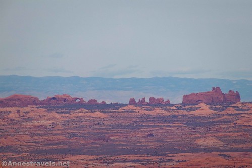
If you look north, you can also see into Arches National Park.
Viewpoint 3 is only about 0.05 miles beyond Viewpoint 2 and offers a fairly similar view – I’m not really sure I’d even call it a real viewpoint unto itself.

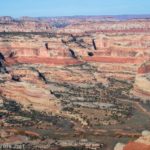
Viewpoint 4 (mile 0.3) offers a definitely different view. You’re looking west at this point, so you get some great views into the Canyonlands (even toward Island in the Sky, though most of the national park is blocked by the nearby cliffs), the Colorado River, and the settling basins at Potash.
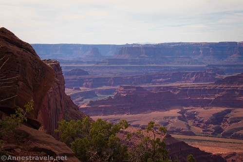
There are two levels to Viewpoint 4. Signs explain about the Anticline and how potash is made. It’s all pretty interesting.

Continue along the trail, which will pass a few picnic tables and finally spit you out back at the parking area, right next to the large sign welcoming you to Anticline Overlook.

Round Trip Trail Length: 0.5 miles
Elevation Gain: 82ft. (5,686ft. to 5,7736ft.)
Facilities: Primitive restroom and picnic tables at the trailhead
Fees: None

Trail Notes: There are steep (and very tall!) cliff edges along this route. While the viewpoints have pretty hefty railings, it’s still not a great place for dogs off leash or small children. I’ve never known even the group members who hate heights to have issues, though. Fun fact: Anticline Overlook is (more or less) the northern terminus of Bear Ears National Monument.

Trail 
![]()
![]()
Road ![]()
![]()
Signs ![]()
![]()
Scenery
Would I go 100 miles out of my way for this? ![]()
Overall Rating: 
![]()

GPS Coordinates for Anticline Overlook
Trailhead: 38.4648400°, -109.6274480° (38°27.89040′, -109°37.64688′ / 38°27’53.4240″, -109°37’38.8128″) (5,710ft.) (0.0)
Viewpoint 1: 38.4657030°, -109.6267270° (38°27.94218′, -109°37.60362′ / 38°27’56.5308″, -109°37’36.2172″) (5,664ft.) (0.15)
Viewpoint 2: 38.4668850°, -109.6274970° (38°28.01310′, -109°37.64982′ / 38°28’00.7860″, -109°37’38.9892″) (5,613ft.) (0.27)

Viewpoint 3: 38.4670150°, -109.6277050° (38°28.02090′, -109°37.66230′ / 38°28’01.2540″, -109°37’39.7380″) (5,621ft.) (0.29)
Viewpoint 4: 38.4670150°, -109.6277050° (38°28.02090′, -109°37.66230′ / 38°28’01.2540″, -109°37’39.7380″) (5,733ft.) (0.33)
End: 38.4647760°, -109.6275260° (38°27.88656′, -109°37.65156′ / 38°27’53.1936″, -109°37’39.0936″) (5,711ft.) (0.51)
The gpx file for Anticline Overlook can be downloaded – please note that this and the GPS Coordinates are for reference only and should not be used as a sole resource when hiking this trail.
Download GPX File size: 13.0 KB Downloaded 448 times
(Note: I do my best to ensure that all downloads, the webpage, etc. are virus-free and accurate; however, I cannot be held responsible for any damage that might result, including but not limited to loss of data, damages to hardware, harm to users, from use of files, information, etc. from this website. Thanks!)

Getting to Anticline Overlook
From Moab, Utah, drive south on US-191. After 32 miles, turn right to cross a cattle guard, following signs for Canyon Rims Recreation Area. The road is paved for the next 23.8 miles. Turn right onto a road that pretty quickly becomes gravel (there may or may not be a sign for Hatch Point Campground – you’ll pass the campground fairly quickly after the turn). Drive the gravel road for 6.4 miles to its end at the Anticline Overlook Parking Area (best marked by a prominent vault toilet, though there is also a large sign).
Today’s Featured Product!
Explore the easier routes and trails in and around Moab in this Falcon Guide. With more than 30 hikes to choose from, you’re sure to find some gems and enjoyable strolls. Buy your copy here!


2 responses to “Spectacular Views from Anticline Overlook”
[…] …and Anticline Overlook. […]
[…] successfully negotiated internet and grocery shopping in Moab, and en route to Miner Overlook and Anticline Overlook in Canyon Rims Recreation Area. (Some things don’t change, even with time…) The pullout on […]