
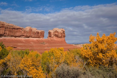
Well, we’re back! It was the craziest, weirdest, most moment-by-moment changes trip we’ve ever had, but we also saw fantastic scenery, spent time together, and hiked well over 100 miles. We explored central Utah, mostly around Moab (including Canyonlands National Park) and in the San Rafael Swell. The cottonwoods were in full color, the La Sal Mountains received fresh snow, and we somehow managed to stay not-too-chilly through it all!
Note: Some of the links in this post are affiliate links. If you click one and purchase something, I may earn a small commission without an extra cost to you.

One interesting change from last year is just how unconcerned most people we met were about COVID. There were still signs asking you to wear masks in buildings and/or social distance. But in general, no one seemed too worried, and very few people wore masks outside, even on crowded trails. We had come prepped for full-fledged germaphobia, but other than masks and hand sanitizer, we didn’t make good on our intentions. Some of that was due to unforeseen circumstances, but we’ll get to that later.

We started out by driving I-70 across the country. It’s been a few years since we’ve taken that route (usually, we take I-80 to I-76 to I-70), so that was a nice change of pace. Glenwood Canyon was open (yay!), so I took some photos as we drove down the highway.

Our first stop in Utah was in the Yellowcat Flat region northeast of Moab. From here, we hiked to a great view into Lost Spring Canyon…
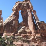
…and into Arches National Park to see Covert (sometimes called Convert) Arch.

It was a pretty easy hike (it would have been even easier if we hadn’t lost our way, but then we wouldn’t have seen Lost Spring Canyon), so in the afternoon some of us hiked down to Winter Camp Arch in the same general area.
On our way to our campsite that night, we stopped to see La Boca Arch (and Herold Arch, but that’s almost not worth talking about). They said the road was fine for high clearance, but we decided it was too steep, tipped, and questionable for our van. So we walked up the access road to the arch.

It rained that night (thankfully, we’d parked on slickrock so we weren’t stuck in the mud!), but the morning dawned with the promise of sunshine. So we set out from the end of a very questionable dirt road, following a pipeline down into Arches National Park. Our destination was supposed to be Clover Canyon – we got there, eventually, but that was a lot of bushwacking and slickrock scrambling and Salt-Creek-hopping later!
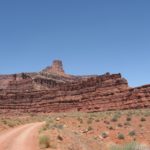
Mission accomplished, I figured we’d make our way down to the Needles District of Canyonlands. We drove into Moab for internet access and staples like ice and bread, then headed south past Wilson Arch.

Canyon Rims Recreation Area is also “along the way.” So we stopped at Miner Overlook…
…and Anticline Overlook.
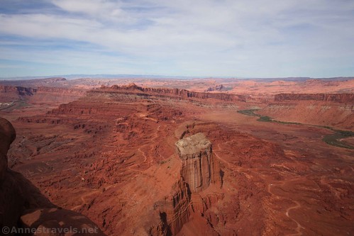
Unfortunately, the van decided to die out of nowhere right there at Anticline Overlook. We called AAA, and they sent out a truck. We spent the next two days trying to get it fixed so we could get back on the trail.

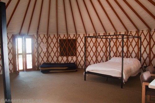
In the interim, we stayed at the very nice ACT Campground in Moab. They have bunk rooms and a yurt as well as tent sites and RV sites. There’s also a very nice kitchen and patio area that is a gathering place for guests and very helpful things like rainy mornings and making supper when it’s cold and dark outside. (So much for social distancing due to COVID…) Except for the constant stream of traffic on US-191, it’s a fantastic place to stay with really nice owners/workers.
Back on track (more or less!), we hiked up to Jeep Arch (Gold Bar Arch). Personal opinion of me: The scenery is great, but the trail is awful. There are so many cairn trails that lead to cliffs and/or just end in the middle of slickrock and brush – it was not my favorite hike at all! But the arch really does look like a Jeep.
The next day we went into the Island of the Sky District of Canyonlands National Park. Driving in, right at sunrise, I had to stop and hike to Mesa Arch in memory of my friend Frank Ruggles. He’d have appreciated that.

Our actual destination for the day was the Gooseberry Trail. It’s the shortest rim-to-White-Rim-Road hike in Island in the Sky… which means it’s pretty much straight down and then straight back up! But I didn’t find it to be too bad.
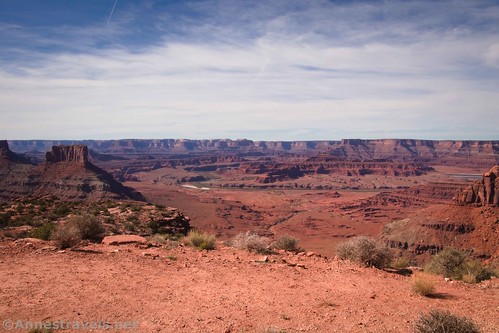
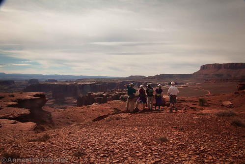
Once at the White Rim Road (we’re here already???) we headed down the road and cross-country to a viewpoint overlooking Monument Basin. We could have scrambled down to the very rim of the basin, but we decided this was a great view and daylight doesn’t last forever in October.
Meanwhile, some of my group had stayed up in Island of the Sky and went to so many overlooks! They had a great time that day. Their favorite was hiking the short Upheaval Dome Trail. I have no idea how we’ve managed to miss out on that trail all of these years!

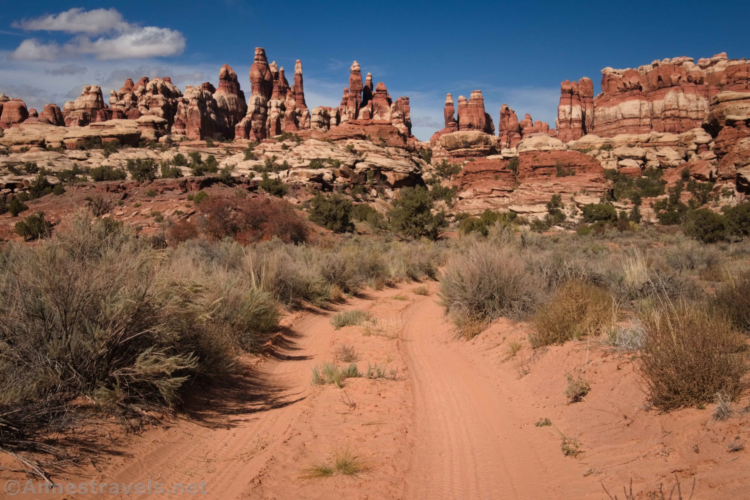
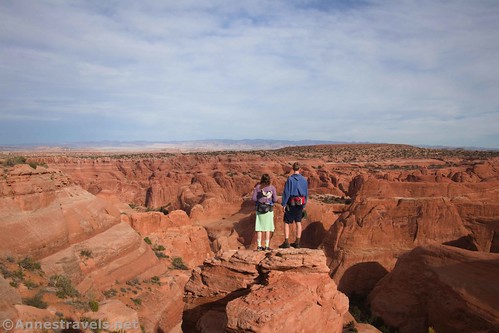
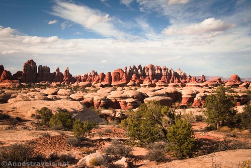
The next day, feeling like we were on a roll, we headed down to the Needles District of Canyonlands National Park (in case you’re curious, it’s about 3 hours to drive between Island in the Sky and the Needles) to hike Chesler Park (via Elephant Canyon and around by the Joint Trail to loop back around Chesler Park). We’ve hiked it twice before, but it’s a true favorite in my group. Still, it’s been about 15 years since the last time we did it and… well, we’d forgotten a few things. Like, the near-constant fantastic views. And the many, many Class 2+ scrambles. And that the road section of the loop could possibly be that short…
A few group members who couldn’t do all of those scrambles went around and did some viewpoints in the Needles. It seems that the district has two trail lengths: very short or insanely long. They did all of the short ones more or less – and I gather they very much enjoyed the Cave Spring Trail.

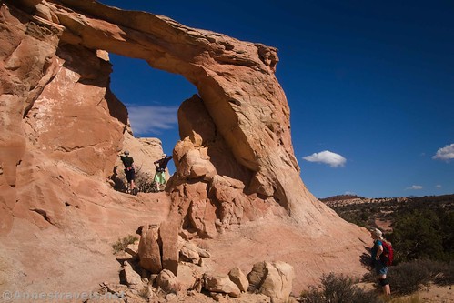
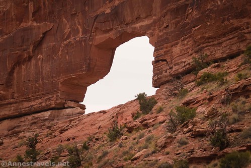
It rained hard the next morning, so we didn’t get out on the trail until after lunch. Given the short days, I figured we would have to take a short hike or two. So we headed up through some great scenery to the very impressive Longbow Arch.

I thought we had time to hike up to Pinto Arch – a trailless excursion off of the Corona Arch Trail – and probably even Corona Arch if we didn’t dawdle. Well, that worked and didn’t work: First, we were pleasantly surprised to find a trail marked all the way to Pinto Arch.

At Pinto, we met a couple of very nice couples, so instead of boogieing off to Corona Arch, we stopped and chatted with them. It was a great use of time per me (it’s fascinating the amazing people you run across!) even though we didn’t have enough daylight to take the extra half mile or so (each way) up to Corona Arch – I’ve been there three times before, so it’s not like I’ve never seen it. The sunset over the Colorado River was outright spectacular on the way down!

With a full day of good weather ahead of us, we drove down to the Needles to hike a loop including the Squaw Canyon Trail. We weren’t sure quite which trail we wanted to do, but I’d heard good things about the Squaw Canyon Loop and the Lost Canyon Loop (it has ladders!) When we got to the critical junction, we studied our maps and made our visual observations and checked the maps and info one more time, and we finally decided to take the Peek-a-boo Trail. It was totally the right decision… none of us could get over the beauty! I’m not sure that the Peek-a-boo Trail beats out Chesler Park for spectacular, but it’s pretty close!
We decided we wanted a hike closer to Moab the next day, so we went up UT-128 to the Kokopelli Trail. It’s actually a 4×4 route, and there were about 20 Ford Broncos on it. But we hiked up the road to see Porthole Arch and Squaw Window. It was a good day with some great scenery.

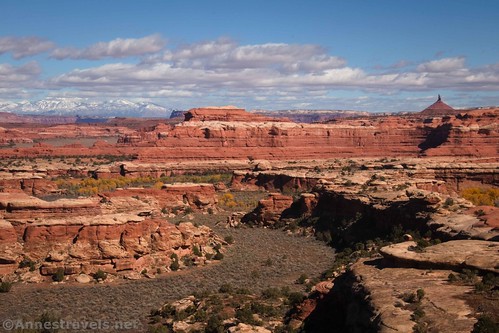
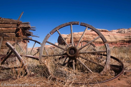
We knew that our time in the area was limited, so I convinced the group that we needed to take the Cottonwood Road just outside of the Needles District to hike into Upper Salt Creek to a viewpoint of Kirk Arch. But our first stop (after the waterfall in Salt Creek – which, by the way, is not the same Salt Creek as in Arches National Park/Clover Canyon mentioned earlier) was an old rancher’s cabin.
Then we did a sage-brush-bushwack to scramble up toward Kirk Arch. Driving in had taken a long time, and we knew we needed to get back, so we weren’t able to explore as much as I would have liked. But we did make it to a great viewpoint below the arch. Meanwhile, a few other members of my group had stopped by a spire commanding a truly fantastic view of Salt Wash.

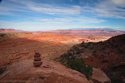
We camped near the Upper Salt Creek Trailhead so that we could take an easy but exceedingly scenic trail/4×4 road to the Big Pocket Overlooks. Talk about beautiful!

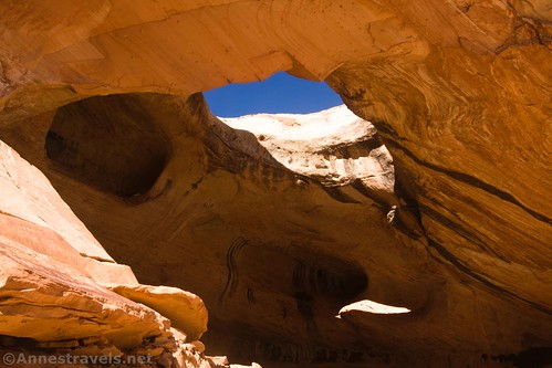
For the last few days of our trip, we moved over to the San Rafael Swell. We’d never been there before – a pity, since it’s a great area filled with slot canyons, and I have a few group members who are about as crazy about slot canyons as I am (sadly, they weren’t with us on this part of the trip). Still, our first hike wasn’t to a slot canyon – just up to Wildhorse Window, which is a hole in the top of a wild little cave. How cool is that?
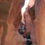
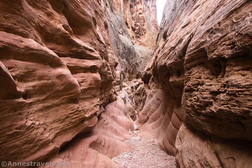
The next day, we figured we might as well do the most famous of all of the slot canyons in the San Rafael Swell: The Little Wildhorse-Bell Canyon Loop. It was such fun, and I definitely recommend doing Little Wildhorse Canyon first… otherwise, you’ll have quite the climb out of Bell Canyon!
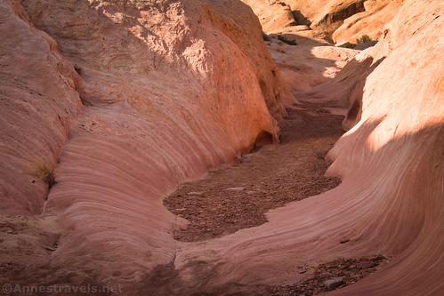
Our final hike was also one of my favorites. On a (trusted) website, I’d read about “the best slot canyons in the San Rafael Swell” aka Baptist Draw and Upper Chute Canyon. There’s an abundance of social trails, we lost our way at least once, and we couldn’t even drive the road all the way to the parking area… but oh, what fun we had! Narrows, puddles, dryfalls, walks above the narrows, it all made for one last fantastically beautiful and crazy fun hike!

Meanwhile, a few of my group had stayed in the main part of the Swell and hiked up Wildhorse Canyon (not the same as Little Wildhorse Canyon).
So be on the lookout, since I’ll be putting out the blogs for all of these in the upcoming months! And if you’ve hiked any of these trails, comment here or on one of my social media accounts (Facebook, MeWe, or Instagram) to let me know what you thought of them!

This Week’s Featured Product!
From here to WOW! Explore 90 trails in Utah’s canyon country, from short strolls to multi-day hikes.