
I’d read that Baptist Draw and Upper Chute Canyon were two of the best slot canyons in the San Rafael Swell of Utah. While I haven’t extensively explored the Swell, I can enthusiastically say that my trek to Baptist Draw and Upper Chute Canyon was one of the most fun, most exciting hikes I’ve done in Utah in a very long time. It’s also beautiful and unique – so as long as you don’t mind way-finding, bouldering, chimneying, no trail, a maze of unmarked dirt roads, crazy terrain, potholes full of water, and tight spaces, I think you’ll enjoy the adventure!
Quick Stats
Note: Some of the links in this post are affiliate links. If you click one and purchase something, I may earn a small commission without an extra cost to you.
Unlike most of the slot canyons in the “San Rafael Swell,” both Baptist Draw and Upper Chute Canyon are a fair bit further north than the eastern edge of the Swell. So, you’ll need to take a maze of dirt roads to the unmarked trailhead. I did it with a semi-high clearance, 2WD vehicle. My van could have handled it just fine, but one or two of the roads had enough hump in the middle that I wouldn’t have wanted to take a Camry on them.

The trailhead – or at least, my trailhead – was next to a juniper tree right before the road went down a 4×4-required slope. It’s only about 1.3 miles from here to where you’d leave the road, anyway, so it didn’t seem worth trying to reconstruct the road to get the vehicle down. We parked and headed east down the road.

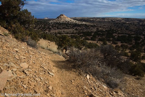
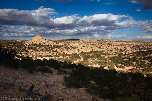
After only 0.4 miles, we came to a road junction. Turn left. Be sure to look around as you hike on the road; while most of the nearby scenery is little more than scrubby trees, views stretch beyond to some interesting buttes and rock formations.

About mile 1.3, I turned left into what seemed to be a camping area (or a parking area). We walked over the canyon rim and then walked back a bit to be able to descend the drainage via a vague trail (you can also just keep walking along the road for a short distance to avoid having to walk along the rim of the canyon). As soon as you leave the road, you’ll be in the Little Ocean Draw Wilderness Area.
The trail descends pretty quickly and without much in the way of obstacles for a quarter mile to drop into a wash. This is an unnamed offshoot of Chute Canyon. Unfortunately for us, I thought we were in Baptist Draw, so we turned cheerfully downstream.
It wasn’t a bad hike. There were a few small dryfalls. But it just wasn’t interesting. We finally figured out our mistake when we came to a very tall dryfall descending into Chute Canyon, proper.

But if you don’t want to waste your time on this, about a tenth of a mile after dropping into the wash, look for a faint trail on the left (north) side of the wash. This should take you up and over hills and eventually drop you into or at least near Baptist Draw. (We just went cross-country and eventually found ourselves walking along above the Draw. We kept on walking until we found a place where we could safely descend into Baptist Draw.)

One of the things you’ll need to realize about hiking in this area is that there are trails – like, cairned trails and plenty of social trails. But then the cairns stop. Or maybe the trails just peter out. So while you do want to follow the cairns in many instances, also use your common sense and be ready to make up your own trail when necessary.

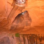
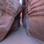
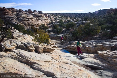
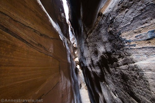
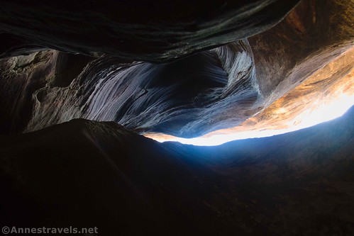
Once we finally dropped into Baptist Draw (2.25 per my GPS; maybe about mile 1.8 if you don’t take the detour that I did), the real fun began. The walls aren’t too narrow at first, but then they begin to close in and rise higher. There are several sets of small dryfalls as the canyon widens and narrows, with some cool formations in the canyon – the things you’d expect to see in a really good slot canyon.
After a while (maybe a quarter mile?) we came to the first massive obstacle – an undercut 10ft. drop with a pothole full of water at the bottom (it had rained recently enough that the canyons possibly contained more water than normal in early November).
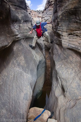
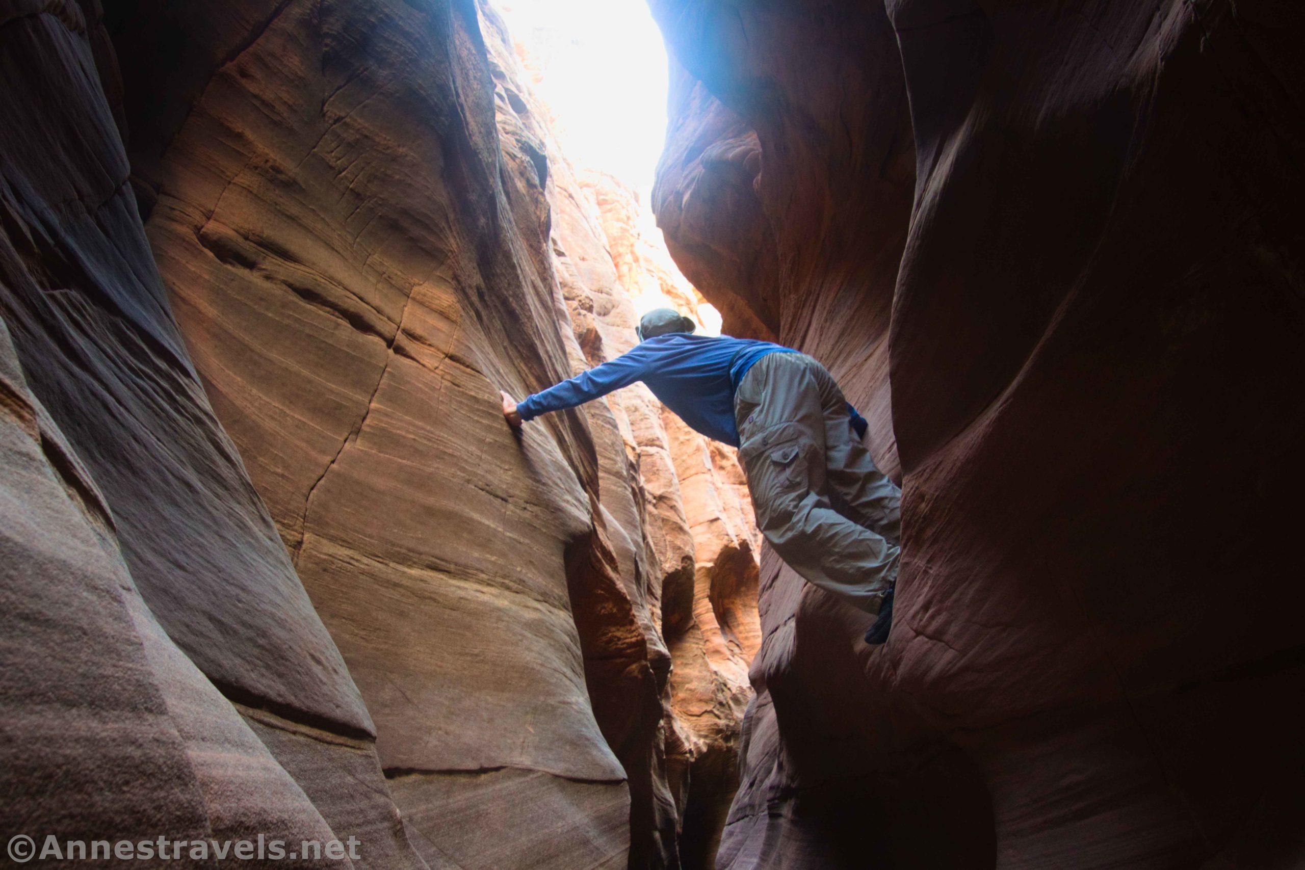
People had left webbing around a boulder stuck in the narrow canyon, so rappelling would be pretty easy. However, I’m no rock climber. So, I chimneyed my way across the puddle and down into the lower canyon.

(If you’re not familiar with “chimneying,” it’s a rock climbing term that more or less means to climb by brancing your feet and hands on opposite sides of a narrow space (or bracing both feet on one wall and your back against the other wall) and inching yourself higher or lower by alternately moving opposite feet (or feet/back) up or down – it’s a great technique I’ve used many times while bouldering and exploring slot canyons.)

It could have been a lot harder, but two of my group members decided they’d wait for me right where they were. I continued downcanyon beyond the puddle through some narrows, around a puddle, down a small (easily negotiated) dryfall, and into some really fantastic narrows.

About 0.5 miles from where I dropped into Baptist Draw (add a tenth of a mile if you’re following the trails further north instead of taking my detour), we came to a dryfall I decided I didn’t really want to chimney. It’s possible I could have done it without a rope, but the others were waiting, and I didn’t want to spend all day in Baptist Draw – we still had Upper Chute Canyon to find!
(FYI – Baptist Draw empties into Upper Chute Canyon about 0.2 miles beyond where I stopped. However, I don’t know what sort of terrain is to be found between here and there or if you’ll need ropes. Remember to never go down something you can’t climb back up!)
We ate lunch in the shade of the canyon, then we headed north following a fairly well-defined trail that wended its way northeast with the terrain. Before long, we found ourselves hiking above Upper Chute Canyon.
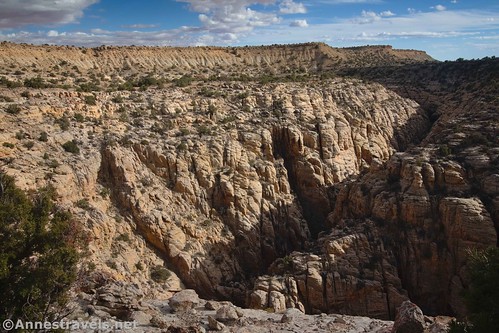
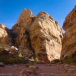
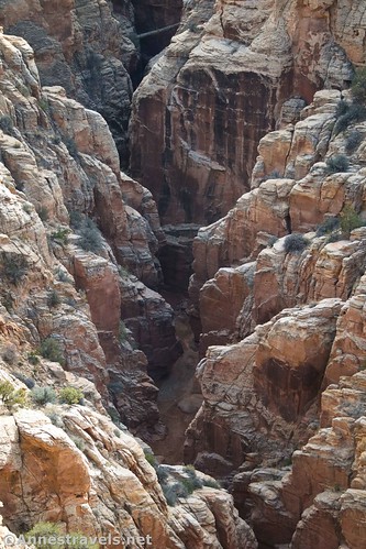
The views down on the canyon were incredible – unlike anything I’ve ever seen before. It was a bit like hiking above a miniature Black Canyon of the Gunnison except with better formations and white walls instead of black. It’s absolutely wild!
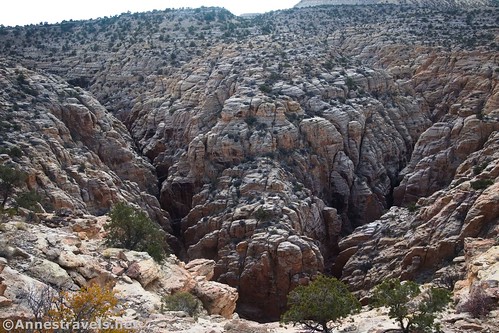
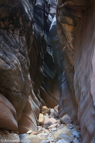
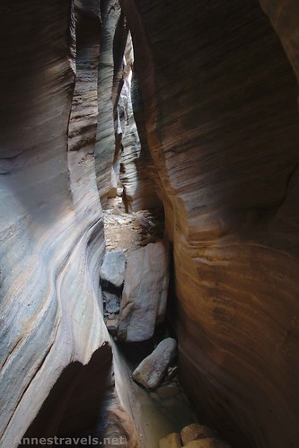
It’s about 1.5 miles between Baptist Draw and where I dropped into Upper Chute Canyon (I followed a trail 80-90% of the time, and it often had cairns!) Upper Chute Canyon is pretty disappointing at first except that it has more red rocks than you’ve seen all day. But as we walked downcanyon, the walls began to narrow and grow higher.

We came to the first obstacle, a chokestone at an angle. It was not fun to get around, and I wouldn’t have tried it if I hadn’t had a few people with me to pull me back up if I found I couldn’t do it alone! But again, someone had left webbing and a piece of rope (not that it might not have been easier to not use the rope, given the angle), so we made it down, back up (to prove it was possible), and then back down to continue exploring.

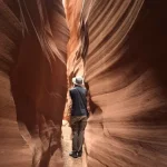
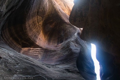
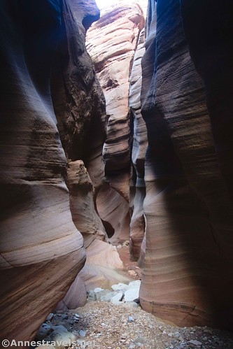
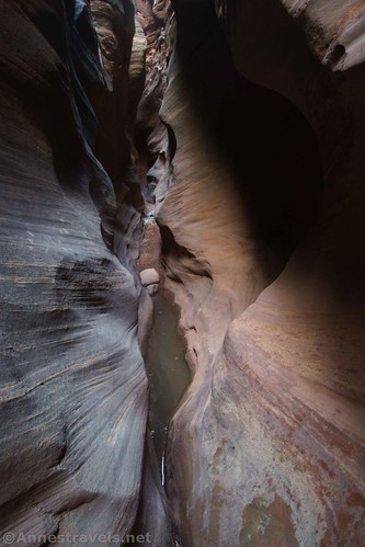
After this, the real narrows began. And wow, were they something else! It seemed every corner you went around, there were more narrows and more sculpted walls. So amazing!
If you only have time for one canyon, I’d recommend Baptist Draw for the easier, shorter hike, but overall Upper Chute Canyon is so much better. From the views en route to the canyon to hiking through the narrows, it’s just an incredible experience!
We crossed over a few small puddles and down a few small dryfalls – nothing that we couldn’t get across with a little chimneying. But then we arrived at a large puddle. The canyon was too wide to chimney and the walls curved in such a way that there was no way to get across without getting our feet wet. One of my group members chimneyed and then jumped, but I knew that wasn’t happening for me. So, off came the hiking boots, and I jumped as far as I could – into ankle-deep water a few inches from dry ground. That could have been a lot worse!

The narrows continued beyond the puddle. In some ways, it was all the same – narrow and sculpted – and in some ways, every single turn was a different view. You can see how the walls became so sculpted when you see the debris wedged into the rock high above your head. Now that’s a sobering thought!

We went a distance further, but one of my group members had opted to not cross the puddle (I can’t say I blame him!) and was waiting for us. Besides, daylight was getting on, and there had been rumors of rain later in the day (it didn’t happen, thankfully!) and we certainly didn’t want to get stuck in a slot canyon during a rainstorm!

So we turned around and went back upcanyon (continuing another 0.6 miles or so would have brought us to the end of Baptist Draw, but as I said, I don’t know what all ropes, etc., you would need to connect the two canyons).

I decided I could jump the puddle from this side, and did it more or less successfully (only the bottom of my hiking boots splashed a little). But right as I jumped, the lens cap fell off my camera. I wasn’t going to leave it behind if I didn’t have to (I always carry an extra lens cap, but I wasn’t thrilled with the idea of littering when it was just a little bit wet). I tried one thing and another and finally ended up taking off my boots – again! – and wading into the knee-deep puddle. Wet and muddy but happier, I put back on my hiking boots and continued upcanyon.

Getting back to the road wasn’t too difficult, except for trying to find a way down into Baptist Draw (a circular path on the map). We followed one trail or another most of the way (the section between the first wash and Baptist Draw has a remarkable number of social trails), dropped into the first wash about a tenth of mile below the trail up to the road, and ascended in the late afternoon sunlight. From there, it was a simple matter of walking back up the road to where we’d parked!

Round Trip Trail Length: My GPS was reading 11.25 when I returned to where I’d parked. After removing a lot of jags from the GPS losing satellite connection while in the canyons (especially Baptist Draw), my track was reading about 9.9 miles.
Elevation Gain: 1,581ft. (6,756ft. to 6,307ft.) per my GPS (not 100% accurate due to low satellite service in the canyons)
Facilities: None. There’s not even an official parking area.
Fees: None

Trail Notes: Don’t try this hike after or during rain. It’s extremely remote, so you should be very experienced with trekking through canyons of this nature before attempting it. You should also be familiar with wayfinding, finding a trail in the desert, etc. Have a backup plan if you end up down a dryfall, and you can’t get out (like, at the very least, tell someone where you’re going and when you’ll return). Never go down a dryfall if you’re not absolutely certain you can get back up it. I’d imagine the canyons would have more water in them in the spring and after monsoon rains, but these canyons can have water at any time of year. Use respect – this is an official wilderness area and as such has tighter regulations than, say, a national forest. I did the entire of my expedition without ropes, but you may want to bring one, especially if you need to lower packs down dryfalls (we took turns carrying our daypack, plus we all had waist packs to be responsible for – even when it was so narrow we had to take them off!) Also, note that I did not have my claustrophobic, not-fond-of-scrambling group member with me that day – and I think she’s glad she didn’t come!

Trail 
![]()
![]()
![]()
![]()
Road ![]()
![]()
Signs ![]()
![]()
![]()
![]()
Scenery
Would I go 100 miles out of my way for this?
Overall Rating: ![]()
![]()

GPS Coordinates for Baptist Draw and Upper Chute Canyon
Note: I started the GPS track at the “trailhead” – near the place where you descend the drainage and down into the first wash. It’s about 1.3 miles from where I parked to the “trailhead.”
Parking: 38.699516,-110.824995 (38°41.97096′, -110°49.49970′ / 38°41’58.2576″, -110°49’29.9820″) (6,756ft.)
Road Junction: 38.696490,-110.818975 (38°41.78940′, -110°49.13850′ / 38°41’47.3640″, -110°49’08.3100″) (6,742ft.) (0.41)
Trailhead: 38.697273,-110.803475 (38°41.83638′, -110°48.20850′ / 38°41’50.1828″, -110°48’12.5100″) (6,747ft.) (0.0)
Dryfall: 38.698811,-110.785835 (38°41.92866′, -110°47.15010′ / 38°41’55.7196″, -110°47’09.0060″) (6,295ft.) (1.40)

Enter Baptist Draw: 38.701328,-110.792784 (38°42.07968′, -110°47.56704′ / 38°42’04.7808″, -110°47’34.0224″) (6,399ft.) (2.26)
Turn Around (not quite) in Baptist Draw: 38.703362,-110.789740 (38°42.20172′, -110°47.38440′ / 38°42’12.1032″, -110°47’23.0640″) (6,321ft.) (3.08)
Enter Chute Canyon: 38.704786,-110.781174 (38°42.28716′, -110°46.87044′ / 38°42’17.2296″, -110°46’52.2264″) (6,308ft.) (5.38)

Trail up to the TH: 38.699570,-110.801271 (38°41.97420′, -110°48.07626′ / 38°41’58.4520″, -110°48’04.5756″) (6,534ft.) (8.30)
End at TH: 38.696877,-110.802871 (38°41.81262′, -110°48.17226′ / 38°41’48.7572″, -110°48’10.3356″) (6,733ft.) (8.56)
End: 38.699515,-110.824980 (38°41.97090′, -110°49.49880′ / 38°41’58.2540″, -110°49’29.9280″) (6,756ft.) (11.23 total)

The gpx file for Baptist Draw and Upper Chute Canyon can be downloaded – please note that this and the GPS Coordinates are for reference only and should not be used as a sole resource when hiking this trail.
Download GPX File size: 101.2 KB Downloaded 459 times
(Note: I do my best to ensure that all downloads, the webpage, etc. are virus-free and accurate; however, I cannot be held responsible for any damage that might result, including but not limited to loss of data, damages to hardware, harm to users, from use of files, information, etc. from this website. Thanks!)
Getting to the Baptist Draw/Upper Chute Canyon Trailhead
Realize that your first adventure will be just getting to the trailhead! I used a Garmin GPS and it did me pretty well. However, cell service is nil out here, so you’ll probably want to use a dedicated GPS or get a map before you leave civilization. (That being said, cell service has improved dramatically in the area since I did the hike – or maybe our Sprint service now also works with a T-Mobile signal?)

From I-70, take Exit 131 toward Mt. Temple Road. Turn south, following the sign for Frontage Road to a sign kiosk. Just beyond the kiosk, a brown BLM sign points toward US-24, Goblin Valley, and Temple Mountain. The road turns away from the highway and continues south – for about 10 miles! Take a right onto W. Lawrence Road (it’s anyone’s guess whether there are signs at these junctions or not) for 3.7 miles, then turn right onto S Temple Junction for 0.9 miles. Turn left to stay on S Temple Junction for another 4.0 miles. Turn left onto Road 3917 (high clearance is required for this road) for 2.4 miles to a place where the road goes down a 4×4 slope. I parked here; you can continue another 0.4 miles to a road junction (go left) and then 0.9 miles to the trailhead, on left, if you have 4×4.
From US-24, take the turn off of US-24 marked for Goblin Valley State Park. When the road to Goblin Valley goes off on the left, continue straight into the San Rafael Swell. You’ll pass several camping areas (both official and unofficial) before climbing out of the Swell and onto the flatland beyond. Drive a total of 20.0 miles from US-24 and then turn left onto S Temple Junction for 4.0 miles. Turn left onto Road 3917 (high clearance is required for this road) for 2.4 miles to a place where the road goes down a 4×4 slope. I parked here; you can continue another 0.4 miles to a road junction (go left) and then 0.9 miles to the trailhead, on left, if you have 4×4.

This Week’s Featured Product!
Explore the San Rafael Swell, from historic cabins to slot canyons to rock art sites, with this book of 32 adventures. Buy it here!