

I think I can safely say that Grand Staircase-Escalante National Monument is one of my favorite parks ever. There’s such a diversity of scenery (i.e., of different kinds of rock formations, badlands, etc.) and most parts aren’t extremely well-visited, so it’s still very much wilderness. Beyond that, free-range camping is allowed (within specific guidelines) which just works better for us than having to drive out of the park every night to find a campspot. So, in this post, I thought I’d list my 10 favorite day hikes I’ve done in the monument. (And while we’re at it, we might as well include the 5 most overrated hikes, too…although most of these are worth a visit if you’re stuck in the park and you’ve done everything else.)
(Affiliate links are present on this page.)
Quick history: We first wanted to visit Grand Staircase-Escalante in
1997, when a group member saw the National Monument on a map in Bryce Canyon. The park rangers discouraged visiting, however, as the land wasn’t developed and there weren’t any official roads or trails yet. Fast forward to 2001. Again, we talked with people in Bryce, and this time they assured us we would find a few things to do; go to such-and-such ranger station and they’ll know what are the best things to see. At that time, Grand Staircase-Escalante was just wilderness.. There was a road to Hole in the Rock and a few picnic tables and a (newly-paved) path at Grosvenor Arch, and that was about it. Cows walked by us while we ate supper at Grosvenor Arch; in fact, finding a place without cows was an issue. However, driving in, we knew we’d found a gem. We did every hike we were able to that first visit, and we just keep returning!
More recently, the exact boarders of Grand Staircase-Escalante have been under debate. But just because a few of the hikes are no longer in the Monument (for the moment, at least) doesn’t mean you can’t visit: the entire area is still federal-owned land, so you can still park and hike as normal. As of 2022, Grand Staircase-Escalante National Monument has been returned (generally) to its former borders.
So, without further ado, here are the 10 best (and worst) day hikes in Grand Staircase Escalante National Monument.
10 Best Day Hikes in Grand Staircase Escalante National Monument
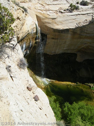
10. Upper Calf Creek Falls. If you’re looking for a bit of solitude, a waterfall in the desert, and no poison ivy until you reach the falls, this may well be the hike for you. Personally, I thought it was a bit hyped more than reality, but it was still very nice. Be sure to continue beyond the large waterfall to a smaller waterfall that falls into a pool. 2.2 miles (3.5 km) RT, out-and-back. (This is in the new Escalante Canyons Unit.)
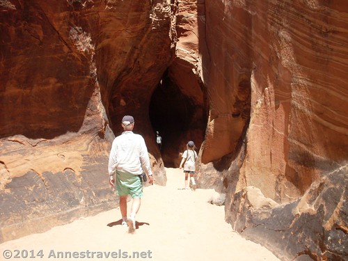
9. Tunnel Slot. This is a cool little slot canyon near the Zebra Slot. (Actually, by following the directions at the link, you can hike overland to the other end of Tunnel Slot – but the official trail is down the wash.) The reason for the name “tunnel” is because the top seems to close overhead in this short slot canyon. 6 miles (9.6 km) RT, out-and-back (7 miles (11.2 km) if combined with Zebra Slot). (The trailhead is along Hole in the Rock Road and is not technically in the national monument, but the slots, themselves, are in the Escalante Canyons Unit.)
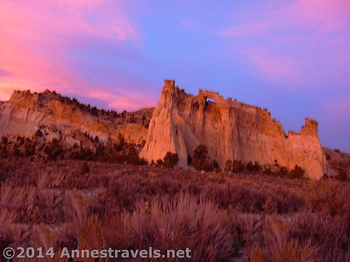
8. Grosvenor Arch. This was one of the earliest attractions in the park, and rightly so. A very short, paved pathway leads to a viewing area, where the crazily shaped arch rises above you. (Though I’ll admit that the last time we visited we found a social trail to climb up behind the arch and look down through it – cool!) It’s a very short stop, but it’s well worth it! About 0.5 miles (0.8 km) RT out-and-back on a paved path. (Grosvenor Arch is in the Kaiparowits Unit.)
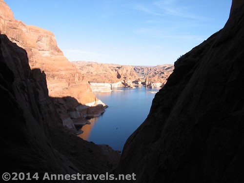
7. Hole-in-the-Rock. This is at the end of Hole-in-the-Rock Road, and requires high clearance to reach (and likely 4×4 as well – we made it the whole way once, but the second time we ended up walking 2 miles (3.2 km) in from a sandy / rocky section we just couldn’t climb without 4×4). The “hole” was created by Mormon settlers wishing to pass down into what is now Lake Powell. The most fun part of this area now is to scramble down the rocky ravine to the lake itself – and maybe even take a quick dip! About 1 mile (1.6 km) RT, out and back; be ready to scramble as there is no trail. (Hole in the Rock was never in the monument anyway – it’s in Glen Canyon Recreation Area!)
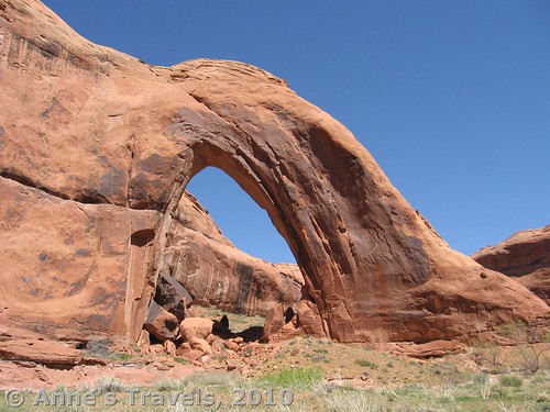
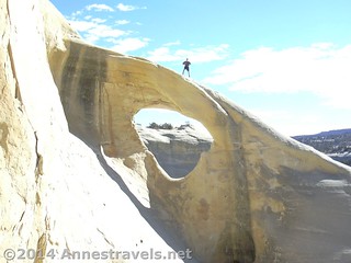
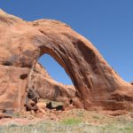
6. Broken Bow Arch. This is just an awesome arch, set deep in a remote canyon. (Actually, we have met people on the trail, but it’s not exactly a popular place by National Park standards.) You can continue to walk beyond the arch in the river, a very nice, peaceful stroll on a warm afternoon. 6 miles (9.6 km) RT, out and back from the arch. (The arch is in Glen Canyon NRA. The parking area is either in Glen Canyon NRA or right on the border of what was once part of the monument and is now federal land. Either way, it should still be accessible.)
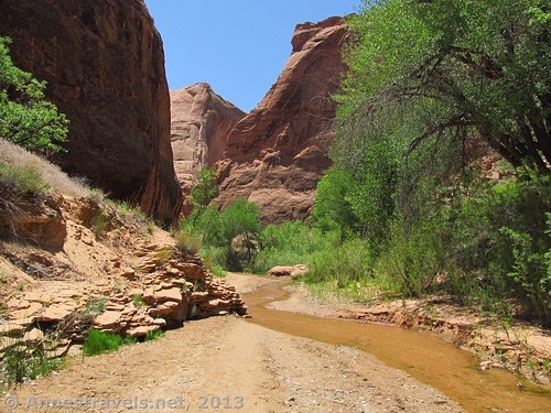
5. Coyote Gulch. Definitely one of the more popular hikes by backpackers, with a bit of scrambling and cross-country travel this can be turned into a very doable day hike. Imagine walking for miles through a deep canyon in ankle-deep water, seeing waterfalls, a huge arch and a natural bridge, and even an old Anasazi dwelling – cool! I’d go back in a heart-beat. 4+ miles (7+ km) RT, out and back. At about 1.5 miles (2.4 km) a steep, sandstone wall must be descended – doable, but not for the faint of heart. (Coyote Gulch is in Glen Canyon NRA. Trailhead is on federal land that was once national monument, but is still accessible to the public.)
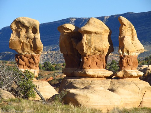
4. Devil’s Garden. This probably is the most popular place in this list. Likely this is due to the fact that it’s also the most accessible place on this list, but it does deserve its popularity. Where else can you drive down a low-clearance-accessible road to a place where you can wander aimlessly through crazy rock formations without getting lost? There are arches, spires, hoodoos, boulders, tri-colored rocks… 0.1+ miles (0.1+ km) RT in whatever loop, out-and-back, or zigzag fashion you wish. (Part of the Kaiparowits Unit.)
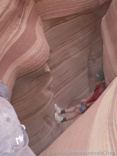
3. Peek-a-Boo and Spooky Slot Canyons (Dry Fork of Coyote Gulch). Not to be confused with #5, these must be some of the coolest slot canyons in Grand Staircase-Escalante. (They’re also fairly popular, so be ready to see people – and to back up when you meet someone coming toward you when the canyon is only 18 in. wide!) I like to climb up Peek-a-Boo, enjoying and photographing the arches at the mouth of the canyon, then walk overland, scramble through a choke stone, and then descend (mostly walking) Spooky, who’s greatest claim to fame is that it’s so narrow you must walk sideways (which gets exciting when you meet someone coming the other direction!) A definite must-do. 3.5 mile (5.6 km) lollipop loop. (No longer in the national monument, but still on federal land and open to the public in a BLM Wilderness Study Area.)
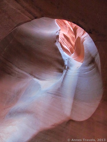
2. Zebra Slots. If you can reach this short slot canyon, it’s one of the prettiest canyons I’ve ever been in. However, notice the if. For quite a while after rains, the mouth of the canyon fills with water, making swimming the only option to reach the pretty part. Still, if you do get in, you won’t be disappointed (and did I mention that the trail to the slot has formations similar to the famous Wave in Vermilion Cliffs National Monument?) 5 miles (8 km) RT out-and-back, if combined with a trip to Tunnel Slot, 7 miles (11.2 km) RT. (The trailhead is along Hole in the Rock Road and is not technically in the national monument, but the slots, themselves, are in the Escalante Canyons Unit.)
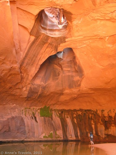
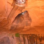
1. Neon Canyon / Golden Cathedral. There’s nothing quite like the Golden Cathedral in Neon Canyon. Seriously. The walls of this canyon glow gold in the noonday sunlight, and the potholes (arches) above add a distinctive charm. Meanwhile, the pool below the potholes glows green and dark as moss and ferns grow in cracks along the far wall. A little over-the-top description? Probably. But it’s still a must-do attraction if you can handle 8 miles (12.8 km) of cross-country travel and a knee+ deep river crossing. My only regret is that it’s so hard to capture its true grandeur in a photograph. (I recommend the Beeline Route over the Fence Canyon Route.) 8 miles (12.8 km) RT out-and-back. (Trailhead is in a BLM Wilderness Study Area and is no longer in the national monument, but is on federal land. The entire hike is in Glen Canyon NRA.)
And a list of the “bests” wouldn’t complete without a list of the “worsts”…
5 Most Over-rated Day Hikes in Grand Staircase Escalante National Monument
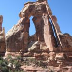
5. Covered Wagon Natural Bridge. This is a fairly unimpressive natural bridge (by Utah standards) and it’s so covered with foliage you’ll be lucky if you can find it. Beyond all this, the road is vague, the directions vaguer, and the arch difficult to get a good vantage point of. ‘Nuff said. 1 mile (1.6 km) RT out-and-back. (While I’m not certain exactly where this lands, it looks as though it has reverted to federal land, not inside the monument.)
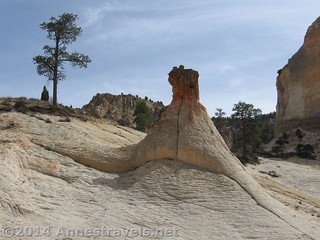
4. The Toadstools. We did this hike because we were told that the formations would likely be gone within our lifetime, so we’d better see them now. I guess I was expecting something a little more exciting, but what we got was some little pinnacles with some rocks on the top…nice, I suppose :-). Anyway, this isn’t a mustn’t-do hike, but I certainly wouldn’t go out of my way for it. 1.5 miles (2.4 km) RT out-and-back supposedly, though I would have said the trail was about twice that. (It appears that either the toadstools are not a part of the monument, or – more likely – they are in a tiny unit of their own.)
3. Lick Wash. Again, I think I had set my expectations a bit high. This is a longish walk through a not-quite-narrow canyon, then – when you finally get to the “end” of the hike – there is one lone pinnacle of rock and a slot canyon through the badlands that is infested with bees. If you’re looking for a walk, or just love walking through canyons, have at it…but I wouldn’t drive a long way out of my way for it. 4 miles (6.4 km) RT out-and-back. (Just barely in the Grand Staircase Unit.)
2. Dry Fork Slot. The Dry Fork Slot is mostly just a sandy wash with some high walls. With Peek-a-Boo Slot and Spooky Slot just around the corner (literally – they branch off of the same wash less than 0.5 miles (0.8 km) apart), who’d want to waste their time here? Not me! 2+ miles (3+ km) RT out-and-back. (No longer in the national monument, but still on federal land and open to the public in a BLM Wilderness Study Area.)
1. Cottonwood Narrows. Very similar to #2, but even wider and less interesting. I’ve only hiked the Cottonwood Narrows once. And I guess I don’t plan to return. It just isn’t interesting enough (unless you just love walking through a sandy wash with canyon walls around you). 3 miles (4.8 km) RT out-and-back. (In the Kaiparowits Unit.)
So now you know my favorites and least favorites…are there any others you’d like to add to the list?
Zoom map in to browse individual hikes around Grand Staircase-Escalante National Monument
This Week’s Featured Product!
Looking for even more hiking ideas for Grand Staircase-Escalante National Monument? This book lists nearly 20 hikes, most of which will take less than a day to accomplish (affiliate link; no extra expense for you).


13 responses to “10 Best (and worst) Day Hikes in Grand Staircase-Escalante National Monument”
[…] For more about my favorite hikes in Grand Staircase-Escalante National Monument, click here. […]
check out a new site for the gsenm
http://www.archesoftheescalante.com
Really cool site! I’ll have to remember this for future adventures 🙂
Great page! Thanks for the info, we hope to do 1/2 half of your top ten this May. I would also recommend Sunset Arch. Also – you referenced “The Wave”, which is Vermillion Cliffs National Monument, not Kodachrome Basin State Park.
I’d love to do Sunset Arch at some point – it’s on the “someday” list. And thanks for the correction; the post has been updated. Hope you have a great time!
Hi: reading your informative report was great. The one issue we are grappling with is we will be in the vicinity in late august also monsoon period. I am having difficulty identifying safe hikes that dont subject us to potential flash floods. Which of the ones above are the safest from that standpoint? Thx Chitra
Hi Chitra, Good question! I’d say Grosvenor Arch and Devil’s Garden are very safe, and Upper Calf Creek Falls, Hole in the Rock, and possibly Broken Bow Arch also shouldn’t be an issue. You could also hike the Neon Beeline Route to the river, but not up Neon Canyon if you want to experience the Escalante desert. Hope that helps and you have a great trip!
Thanks Anne we will look at the hikes you mention! Best Chitra
Hi Anne: Just one follow up question: Could we access the hikes you recommend off paved roads or do we need 4 wheel drive and high clearance to do so? Thx Chitra
[…] Gulch, Grand Staircase-Escalante National Monument, […]
[…] Upper Calf Creek Falls in Grand Staircase-Escalante […]
[…] Gulch is one of my most-visited posts. Grand Staircase-Escalante National Monument, […]
[…] are pretty consistent from year to year – The Best (and Worst) Hikes in Big Bend National Park, The Best (and Worst) Day Hikes in Grand Staircase-Escalante National Monument, DIY Bug Screens, The Best (and Worst) Day Hikes in Anza-Borrego Desert State Park, Coyote Gulch, […]